FOUR NEW NATIONAL PARKS DECLARED FOR ABACO
Report by Friends of the Environment, PO Box AB 20755 Marsh Harbour, Abaco
|
|
|
|
The Minister of the Environment, The Honourable Kenred Dorsett, announced yesterday that the Government of the Bahamas had declared 18 new and expanded protected areas in The Bahamas, four of which are in Abaco! These proposals were the culmination of work by so many different organizations and individuals. This is a landmark moment for conservation in The Bahamas and we are so proud to have been a part of making it possible.
Information on Abaco’s parks are below. The main purpose of the proposals is to preserve the habitat in order to ensure that both current and future generations of Bahamians and visitors will be able to enjoy these areas as they do now. Fishing within the boundaries of the existing laws is still permitted in these areas. The Bahamas National Trust in partnership with the local groups and communities in Abaco will create the management plans for each area. The management plans will help determine specific guidelines for use.
Thank you for these declarations!
|
|
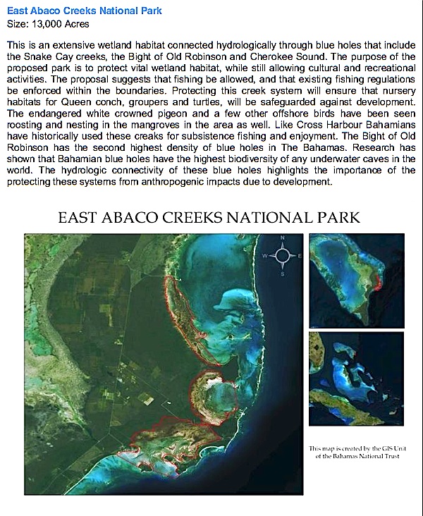
EAST ABACO CREEKS NATIONAL PARK
(Snake Cay, The Bight of Old Robinson & Cherokee Creeks)
This park was a long time coming. Frank Kenyon, a founder of FRIENDS and the namesake of our new research centre, has copies of letters that he wrote to the first Prime Minister of The Bahamas lobbying him to protect the Snake Cay Creeks. The protection of these creeks has indeed been a long process that has involved the passion and hard work of so many people in the community.
|
|
| Proposed Boundaries for the East Abaco Creeks National Park (Boundaries may vary slightly) |
|
|
|
| Jungle Creek in The Bight of Old Robinson |
|
|
CROSS HARBOUR NATIONAL PARK
Cross Harbour is one of the most productive wetland ecosystems in Abaco, and it may be the primary nursery for all of southern Abaco. It is a breeding area for nurse sharks and conch and is under study as perhaps the most important bonefish breeding ground on the entire Little Bahama Bank. More info
|
|
| Sharks breeding on Cross Harbour Bank |
|
|
| Aaron Adams from Bonefish Tarpon Trust and David Philipp from Fisheries Conservation Foundation measuring a bonefish during a tagging project. Over 3,000 bonefish have been tagged in Abaco through a partnership with NGO’s such as BTT, the AFFGA and independent guides and lodges. This tagging effort helped reveal the importance of protecting both Cross Harbour and The Marls for sustaining bonefish populations. |
|
|
|
THE MARLS NATIONAL PARK
The Marls include some of the most productive and expansive bonefish flats in The Bahamas. Anglers from all over the world have travelled to Abaco to fish the Marls. It is also home to migratory and resident birds, sharks, and other juvenile wildlife.
|
|
|
A rare sighting of a sawfish in The Marls
Photo taken by angler Jacqueline Cannon
|
|
|
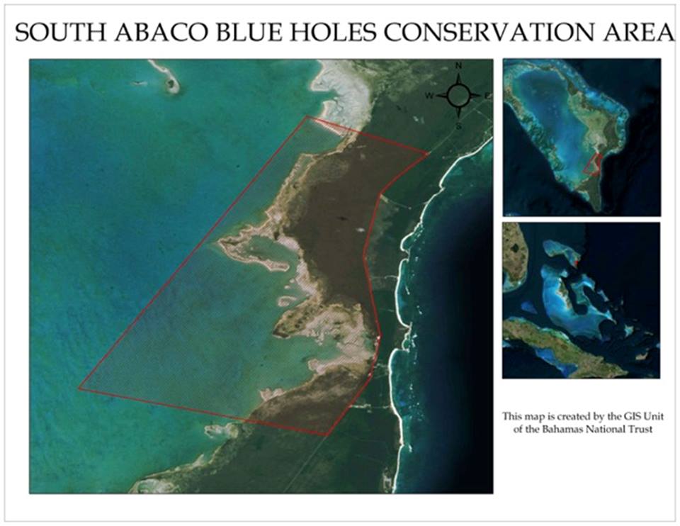
SOUTH ABACO BLUE HOLES NATIONAL PARK
(including Sawmill Sink, Dan’s Cave, Ralph’s Cave, and Nancy’s Cave)
The Blue Holes of South Abaco have been featured internationally as some of the most highly decorated blue holes in the world. Not only are they beautiful but these blue holes are important. For example, Dan’s cave has the highest diversity of cave adapted life in the WORLD! More Info
|
|
| The Glass Factory in Ralph’s Cave |
|
|
|
|
|
|
MAPPING ABACO’S FOUR NEW PROTECTED PARKS


ABACO’S FOUR PROTECTED AREAS: THE PROPOSALS
The latest version of the 40TH ANNIVERSARY OF THE BAHAMAS PROPOSAL FOR THE EXPANSION OF THE PROTECTED AREA SYSTEM OF THE COMMONWEALTH OF THE BAHAMAS has been published. It is a joint proposal by the Bahamas Government, The Nature Conservancy and the Bahamas National Trust. The breadth of the scheme is very ambitious, affecting all the principal Bahama Islands. To understand the objectives and scope of the project, you can see the whole 34-page project by clicking BAHAMAS PROPOSED PROTECTED AREAS 2014 It is in pdf format, so you should be able to save it if you wish to.
Many people will be familiar with the proposals as they affect Abaco. However since the latest version appears to be a final draft, I thought it might be helpful to show the 4 proposed areas of protection and conservation in their present form. These are, in summary:
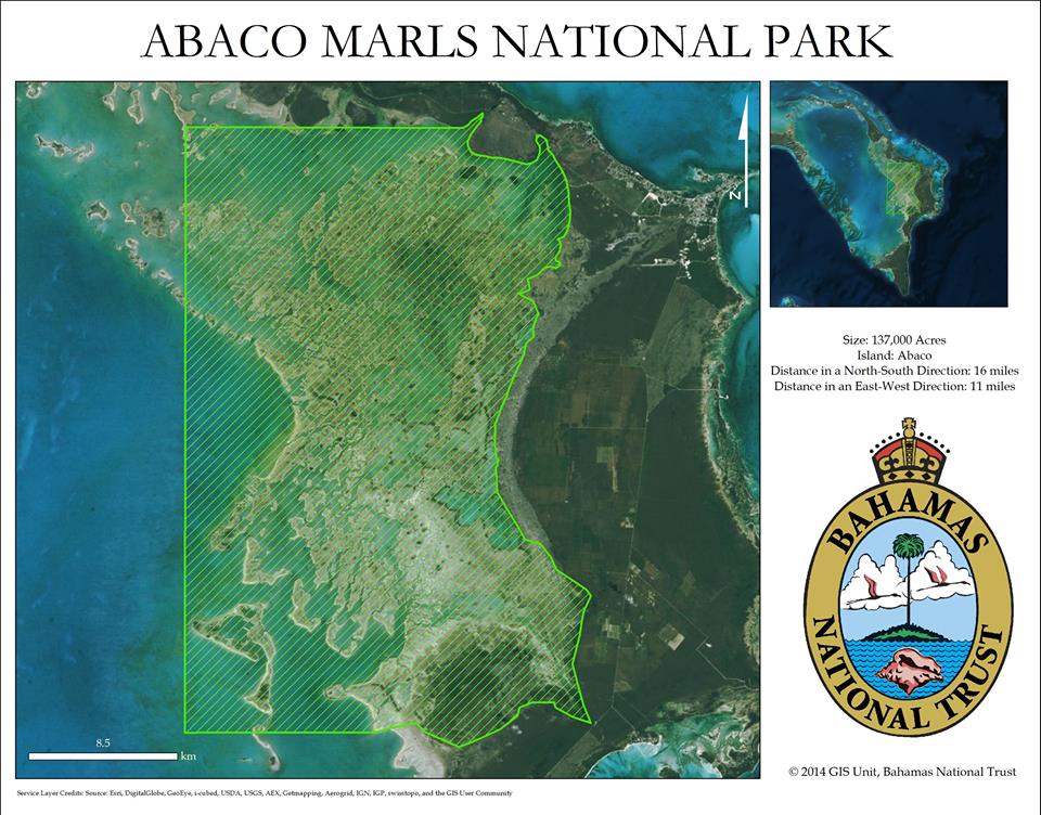
- THE ABACO MARLS NATIONAL RESERVE A vast area of nearly 200,000 acres (300 square miles) of mangrove flats, sandbanks, creeks and wetland habitat
- EAST ABACO CREEKS NATIONAL PARK 13,000 acres (20 square miles) of wetland habitat that provides a vital wildlife nursery, and includes blue holes, creeks and a significant area for recreational activities (though Pete’s Pub at Little Harbour may be just outside the zone…)
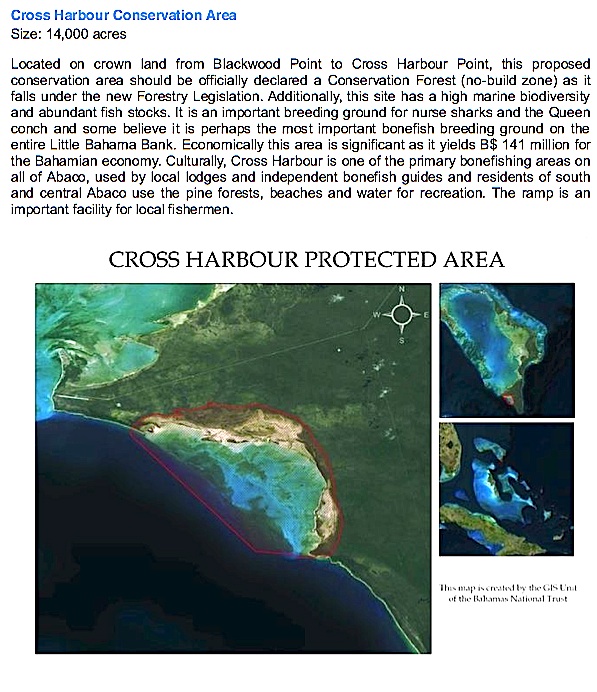
- CROSS HARBOUR PROTECTED AREA 14,000 acres (21 square miles) in South West Abaco, a crucial breeding area for a number of species,including bonefish
- SOUTH ABACO BLUE HOLES CONSERVATION AREA A huge 34,000 acre (53 square miles) swathe of South Abaco to the west of the E D Highway, incorporating 4 inland blue holes and important cave systems, and 13 offshore blue holes. This is an area of mainly pine forest on land and low waters at sea, with an anticipated value for eco-tourism
Here are the BNT maps showing the extent of each area. Far more information will be found via the link to the report given above.
THE ABACO PROPOSALS


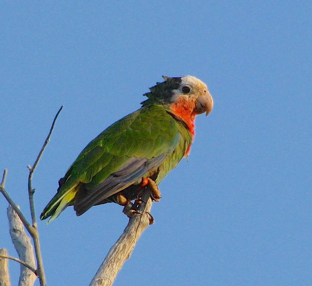
Credits: Parrot, (ex-)parrot protector Caroline Stahala; Maps, BNT; acres to sq m conversion, Gizmo!