26 AUG: HURRICANE IRENE CONTINUES ON ITS (HER?) WAY
NB FOR LATEST ABACO / IRENE INFORMATION SCROLL UP TO TOP POST OR SEE TOP OF THE ‘RECENT POSTS’ IN SIDEBAR
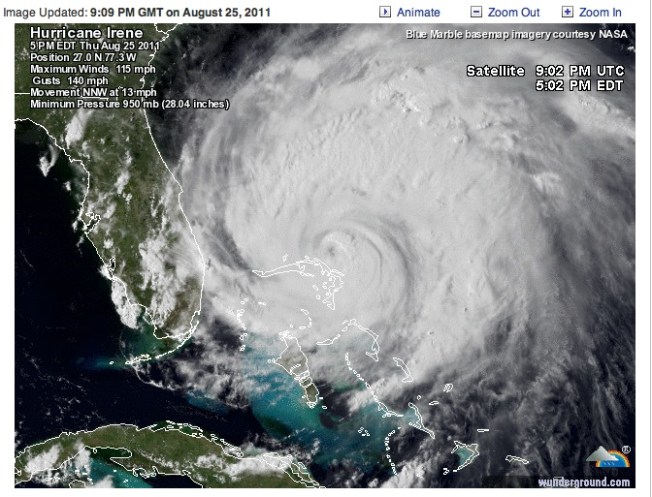
25 Aug midnight GMT – final post of the day: a Wundermap showing Irene at last starting to move northwards from Abaco. Until tomorrow (rollingharbour GMT), best of luck to all on Abaco for the rest of today…

Hurricane Irene at Abaco - Satellite Image as the eye of the storm moves north Updated Aug 25 17.00 LT, 22.00 GMT Click Me!
HURRICANE IRENE ABACO 25 AUG UPDATED 17.00 LT, 22.00 GMT
NOAA SATELLITE & INFO SERVICE Tropical Atlantic Visible Loop of Irene
Check out direct links to radar / tracking info under the main picture below Check out the progress of Irene using STORMPULSE (check for updates) Check out WATTS UP WITH THAT for additional useful info / maps
SELECTED MEDIA & NEWS REPORTS 25.08.11
NEW MIDDAY VIDEO NEWS REPORT from MARSH HARBOUR on Local10.com with graphic images and some ![]() streaming
streaming
SHORT IRENE VIDEO posted by the Hope Town Inn & Marina at about 13.30 today – you can just see the lighthouse through the mayhem… [you may need to be on Facebook and logged in for this to work]
VIDEO NEWS REPORT FROM MARSH HARBOUR on Local10.com “Abaco Island, Bahamas Awaiting Hurricane Irene: Local 10’s Janine Stanwood reports from Abaco Island as Irene moves northwest”, early morning 25 Aug
CBS MIAMI report (apologies for large & inappropriate Aquafresh ad) NASSAU GUARDIAN the eye of the storm nears Abaco [11.00 local time] TIME (TECHLAND) NASA SATELLITE VIEW of ABACO & REPORT INTERNATIONAL BUSINESS TIMES (with tracking links) ASSOCIATED PRESS (article not current, check for updates)
ABACO FORUM.COM the well-known local Abaco resource. The link should take you to page 9, currently the last page (the posts go backwards). I expect this will have increasing numbers of personal accounts of Irene as the hours pass.
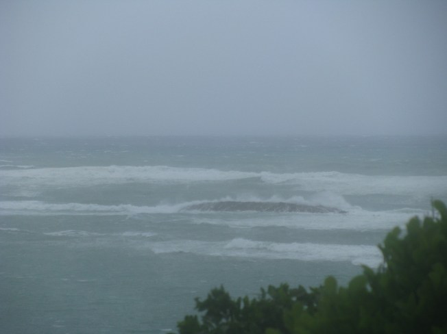
STOP PRESS 24 AUG CURRENT WEATHER AT ROLLING HARBOUR, ABACO, AUG 24 p.m. AS HURRICANE IRENE APPROACHES
This photograph was taken this afternoon, 24 August, at Rolling Harbour on the east coast of Abaco about 25 miles south of Marsh Harbour, down towards Crossing Rocks. Irene is about 300 miles away. Caroline Stahala, who took the photo, reports “serious wind and sea surges”. Thanks, Caroline, for giving us an idea of what is on its way…
To check out a wide variety of trackers, forecasts, radar maps and so forth, all on one convenient page (thanks, Wunderground) CLICK===>>> IRENE
To view the dedicated tracking map CLICK===>>> Hurricane Irene : Tracking Map : Weather Underground and scroll down to the large map
To view the storm-centered satellite image CLICK===>>> Hurricane Irene : Storm-Centered Satellite Image : Weather Underground
Finally, for more technical stuff and other tracking maps, check out the ever-reliable and all-knowing Abaco weather information phenomenon that is BAROMETER BOB

Credit: 'Watts Up With That" - Click image for Hurricane Irene page of this excellent weather & climate site
WEATHER NEWS FLASH 23 AUG
HURRICANE IRENE is en route to Abaco, expected on Thursday 25 August, (based on Marsh Harbour Hurricane Irene tracking predictions). It looks as though the storm may work its way north along the eastern coast from Hole-in-the-Wall up past Crossing Rocks, Schooner Bay, Rolling Harbour (Delphi Club) and up towards Marsh Harbour via Cherokee & Little Harbour… but the tracking predictions are variable as the storm approaches
WE ARE THINKING OF YOU…


