HURRICANE MATTHEW & THE TRUE MEANING OF “AWESOME”


hurricane-matthew-nasa

Hurricane Matthew, NASA aerial view

HURRICANE MATTHEW & THE TRUE MEANING OF “AWESOME”

As Hurricane Matthew sweeps northwards, with Abaco in its path for the hit tomorrow, it’s an opportunity to take a look at the power and might of extreme weather, and maybe to recalibrate the word ‘awesome’ from its current diluted usage. The images used all relate to the state of play in the last 24 hours.

Hurricane Matthew_satellite view (NASA)

Satellite view at 14.00 EDThurricane-matthew-satellite-clip-wunderground

The concept of ‘awe’, historically and Biblically, comprised emotions such as wonderment, astonishment, terror and dread. Biblical translations use ‘awe’ and ‘awesome’ almost exclusively to refer to God or to His Works. In many Biblical instances of people being awed, they not only experience extremes of emotion but also exhibit palpable signs of fear – shaking, cowering, falling down, prostrating themselves.

Aerial view of Hurricane Matthew from the International Space Station, October 4hurricane-matthew- aerial view (ISS/ NASA)

The perfect example of the ‘proper’ meaning of awesome can be found in Genesis: ‘He (Jacob) was afraid and said, “How awesome is this place! This is none other than the house of God, and this is the gate of heaven.”‘ Some translations use the word ‘dreadful’ in place of ‘awesome’ for this passage – in its old meaning of ‘full of dread’, not its watered down modern meaning as in ‘dreadful headache’ or ‘dreadful nuisance’ (the same dilution that has happened to ‘terrible’).

Hurricane Matthew Tracking Path (Wunderground)

WHAT KIND OF EMOTION IS AWE?

In 1980 a man called Dr Robert Plutchik designed a ‘diagram of emotions’ in a floral wheel format. This device visualised eight basic emotions, with eight derivative emotions each composed of two basic ones. Awe is at 4.00 o’clock, showing the extreme of the Biblical meaning as a mixture of terror and amazement (think of the reaction of the shepherds while watching of their flocks, when unexpectedly interrupted by an angel…). There’s no place in the wheel for ‘awesome’ to mean ‘I really like that photo you took’. Or, ‘your soup is delicious’. Or, ‘I am so pleased to have made a plan to meet you at Pete’s Pub’.
plutchik-wheel-svg

Language is a living thing, and the hyperbolic application of powerful words to mundane emotions or objects is widespread and unsurprising. But a Cat. 4 hurricane really is awesome stricto sensu: it is both an amazing ‘extreme weather event’, and a terrifying one, as the header image and the many images of Matthew’s progress posted online amply  illustrate. The recent practice of  giving hurricanes comfortable names does nothing to dispel their power or the awe they inspire.  On present tracking, Matthew will reach Abaco some time tomorrow. From a safe distance, I wish everyone on Abaco and elsewhere in the target zone all the very best and a safe passage through the storm.

hurricane-matthew-wunderground-clip

HOW ARE HURRICANES CATEGORISED?

Credit: 'Watts Up With That" - Click image for Hurricane Irene page of this excellent weather & climate site

 FROM ASTOUNDING TO BADASS: AWESOME SYNONYMS ANCIENT & MODERN

Astounding, breathtaking, amazing, stunning, astonishing, awe-inspiring, stupendous, staggering, extraordinary, incredible, unbelievable, magnificent, wonderful, spectacular, remarkable, phenomenal, prodigious, miraculous, sublime, formidable, imposing, impressive, mind-boggling, mind-blowing, out of this world, supercalifragilisticexpialidocious, amazeballs, badass

hurricane-matthew-tracking-clip-craig-setzer-jpg-copy

Credits: Nasa / Goes, NASA / ISS, Wunderground, Craig Setzer

HURRICANE SANDY AFTERMATH: ABACO PICTURES, NEWS FROM DELPHI CLUB, BAHAMAS & MANATEE UPDATE


DAMAGE FROM HURRICANE SANDY AT THE DELPHI CLUB, ABACO

The storm has passed from the Bahamas and the clear-up is underway – but further north communities are bracing themselves for the onslaught. The news today  from contacts, from Facebook and the web generally, is of thankfully little lasting damage, with power and comms restored in many places. There’s been plenty of flooding – eg Sandy Point – and tree / plant mayhem.

The Delphi Club was again, as with Irene last year, almost directly beneath the eye of the storm. Then, a couple of leaves were lost from the pineapple crown (above), a few fittings were smashed, and the gardens were unceremoniously rearranged. Peter Mantle, Delphi Club supremo, has posted his record of the last few days at the club – the approach of Sandy, the storm, and the aftermath. I am posting extracts below, to be read (chronologically) from the bottom entry to the top of the page. For those who haven’t experienced a storm of this violence, Peter’s account gives a vivid picture of the before, the during and the after…

Apologies for having posted about Sandy in detail with maps etc, and at the crucial time tailing off  while I was away and had only an iPhone™  and a sporadic connection…

STOP PRESS: AMERICAN OYSTERCATCHERS – BRAVE OR FOOLISH? 29 October

Peter Mantle has just sent me a ‘Sandy’ photo from the Delphi Club beach, showing a group of oystercatchers on the rocks at one end of Rolling Harbour. Storm detritus already festoons the rocks. Have the birds seen what’s about to hit them? Are they waterproof? 

STOP PRESS: BMMRO MANATEE UPDATE 29 October

The BMMRO has posted news from Sandy Point and for those who have been asking after manatee Georgie’s welfare, an update:

“Hi Everyone, everything is ok here at the research center! We are working on getting information on Georgie’s whereabouts and we will happily update everyone as soon as we hear anything. There’s still a bit of damage here in Abaco that is preventing travel but hopefully we will be able to get up to Georgie soon”.

STOP PRESS: SOME ABACO IMAGES 28 October

(credits to Timothy Roberts & Cindy James Pinder and their facebook posts)

SANDY TAKES BONEFISH; DARK HUMOUR ON DARK DAYS

OCTOBER 27th Among the many bits of minor damage caused by Hurricane Sandy was the destruction of our bonefish weather vane. This had been hand-made by the other Sandy, our general manager, and stood atop his lodgings. Snapped off, the copper creation was found nearby, bruised and dented, rather like ourselves.

Yet again, we have been very fortunate – staff and guests are all well. And most of the damage caused by the 100mph winds was minor. The storm had its moments, but the worst bits were at nighttime when many people were huddled safe in bed. Lots of bumps and bangs provided a spooky soundtrack, but it was more of a B movie than a full-blown Hollywood epic. That said, I hate to think what a really big Category 3, 4 or 5 hurricane would be like.

We still have no mains electricity; thank God for the gennie. We have no phones or mobile connection, so we have little idea of what is going on elsewhere on the island. We hope for the best but fear not all will have escaped as lightly as we did. Some of the staff from Crossing Rocks are stranded here by flooding. But the wireless internet is back so all will soon be revealed.

Yet again, the gardens have been shredded. The banana trees have been snapped off mid-fruiting. My favorite banyan tree has broken in half again, having nearly bounced back from Irene. The big Bismark ferns are banjaxed, the bougainvillea is blasted leafless and the pool is a mess. But who cares. We are fine. Dunkirk spirit? Well, very black humour and spirits of a different kind have seen us through.

“I survived Sandy” T-shirts are now in preparation, but that’s a staff joke about their hyperactive and heroic boss…..

A BAD HAIR DAY…

OCTOBER 25th It is getting distinctly breezy here, with winds as bad as any Irish gale. But Hurricane Sandy, now upgraded to a Category 2 hurricane, is still some 18 hours away and currently features average winds of 105mph with higher gusts. It may get even worse, they say. So no fishing today. More guests have made it in. Bahamasair even ran a plane out of Nassau at first light this morning.

While we still have power and phones, the lines are buzzing and we are glued to the internet. It seems odd to see that Sandy is the lead news story on the BBC. Non-technical guests have adjourned to the library (where “A Perfect Storm” and “Winnie the Poo and the Blustery Day” are current favourites). The air of gloom is more attributable to the fact that Arsenal lost at home last night than to any fears for personal safety.

We may go quiet for a while.

NOTHING VERY FEMININE ABOUT THIS SANDY

OCTOBER 24th, noon Tropical storms are now given boys’ and girls’ names alternately; in the old days they were all girls. The one that currently threatens us is Sandy, a name that is more commonly applied to females in this part of the world. But there is nothing too feminine about this storm; as the forecast deteriorates and Sandy intensifies into a hurricane over Jamaica, we are becoming more and more concerned by its macho capabilities.

The National Hurricane Centre now predicts that Sandy will pass very close to Abaco – the predicted path having shifted overnight. As it now looks, the eye may pass just 25 miles from us, which would basically be a direct hit since damaging winds spread far out from the centre. We are going to have to keep a very close on on this little girl over the next 48 hours.

ALL EYES ON SANDY

OCTOBER 23rd No sooner has the Club reopened for the new season than a tropical storm appears on the horizon. And, in a twist of divine humour, it’s been christened after our general manager, Sandy.

Sandy (the mostly human version) is tracking Sandy (the swirling tempest) on an hourly basis. As it now stands, we are in the “cone” of the likely track of the storm over coming days. Currently south of Jamaica, TS Sandy is turning north and could yet morph into a hurricane. It’s expected to be over or near us by Friday night, with “average” winds of nearly 60mph and gusts of up to 90mph.

Hatches will therefore be battened, outdoor furniture put back indoors and supplies of grog reinforced. The lucky fishers in residence will have to take a breather, while the new chef, John, will receive a special form of baptism.

Tropical storms this late in the year are a great rarity. Somehow that is not very reassuring just now. But the forecast for the following week is rather better… 

Click image to visit the Delphi Club

A MAP OF HURRICANES WORLDWIDE SINCE 1851: THE PLANET’S HOT-SPOTS


HURRICANE PATHS ON PLANET EARTH

Hurricanes. Extreme weather events that can strike anywhere in the world’s vulnerable zones. But where are these to be found? And in those zones, is there any historical evidence demonstrating that particular areas of the world are more vulnerable than others? A recent post on the very informative ABACO SCIENTIST website includes a comprehensive map of all hurricanes recorded since 1851. This map gives a clear picture of the hot-spots and danger areas. 

Delphi Club Abaco 25 Aug 2011 / Hurricane Irene: Looking south from the balcony

The source is NASA and the article may be found HERE. I reproduce the map and explanation, with acknowledgement to John Nelson and IDV Solutions. Each blue link in the explanation below will take you to a new source of hurricane information, so the article is a valuable resource as a gateway to further hurricane knowledge.

EXPLANATION AND WORLD MAP

“Should you be worried about hurricanes? To find out, it is useful to know where hurricanes have gone in the past. The Earth map shows the path of every hurricane reported since 1851, Although striking, a growing incompleteness exists in the data the further one looks back in time. The Earth map graphically indicates that hurricanes — sometimes called cyclones or typhoons depending on where they form — usually occur over water, which makes sense since evaporating warm water gives them energy. The map also shows that hurricanes never cross — or even occur very near — the Earth’s equator, since the Coriolis effect goes to zero there, and hurricanes need the Coriolis force to circulate. The Coriolis force also causes hurricane paths to arc away from the equator. Although incompleteness fogs long term trends and the prevalence of hurricanes remains a topic of research, evidence is accumulating that hurricanes are, on the average, more common and more powerful in the North Atlantic Ocean over the past 20 years.”

Image Credit & Copyright: John Nelson, IDV Solutions

The eye of Hurricane Irene passes directly over the Delphi Club, Abaco 26 August 2011

The image below was shared on Facebook, but I don’t have the inventor’s name. I’m sorry not to be able to identify the originator of this ingenious hurricane warning. Every home should have one… 

HURRICANE ISAAC LATEST UPDATES 30 AUGUST; IMAGES; TRACKING; MAPS; SAFFIR-SIMPSON SCALE


AUGUST 30

Noon GMT Some more pictures overnight – a selection of clips from a short HuffPo video

AUGUST 29

22.00 GMT Latest news: Hurricane Isaac has just been downgraded to a Tropical Storm (I realise that for those caught up in the heart of flooding, damage and widespread outages, this may be of little practical comfort – but it is perhaps some encouragement for those further north in the path of the storm).

18.00 GMT Some pictures are now coming out giving an idea of the ferocity of the storm. I’ve assembled a short gallery from Reuters, AP/Getty and similar news resources, which I will add to as and when…

DANGER SIGNWRECKED PIERHURRICANE CHANCERS… ARE THEY CRAZY?NEW ORLEANS POLICE ON PATROLUPROOTED TREEBUILDING DAMAGEROUGH SEASFALLEN TREEIS THIS WOMAN BEING SENSIBLE?

NOA SATELLITE IMAGE AUGUST 29th

Noon GMT The latest Wunderground tracker map for Hurricane Isaac shows the storm’s current position and its subsequent path, decreasing to tropical storm and then tropical depression as it sweeps northwards through Arkansas. The eastwards tendency, noted previously, is now pronounced with the storm predicted to turn towards Missouri and Kentucky.

09.00 GMT Having had many hundreds of hits for this storm post, including a great many from the southern coastal states of the US, I am posting some further information about Hurricane Isaac today, as the storm rages over New Orleans and more widely across the state. 

I have been wondering about the New Orleans flood defences that are constantly referred to in news reports, so firstly here is a clear map of the situation showing the reinforcement since Hurricane Katrina 

Here is a satellite video of Hurricane Isaac approaching the US coast, taken over two days. It vividly shows the development in the Gulf of Mexico from a “disorganised” tropical storm into a swirling, concentrated hurricane-force storm, with the eye becoming visible as it approaches the coast.

Finally (for now) this is the astonishing view from a space station, giving an idea of the storm’s extent

AUGUST 28

Posting suspended

AUGUST 27

TS ISAAC STORM TRACKING: LATEST UPDATE 23.00 GMT

GOES satellite image of TS Isaac 27 August Noon

TS ISAAC STORM TRACKING: LATEST UPDATE 09.00 GMT

Here is this morning’s (GMT) tracking map, with the storm in the Gulf of Mexico, still drifting westwards. Predicted landfall is now mainly on the Louisiana coast. The most significant change overnight is that the Cat 2 prediction has been downgraded, so that the max expected strength is Cat 1

The satellite picture shows Isaac thickly covering the Gulf of Mexico with dense cloud. The coloured markings to the right show the data recorded by the NOAA Hurricane Hunter flying on the eastern edge of the storm (where the winds are less)

Since this is a Bahamian-based blog (with close Florida connections) Isaac’s current position makes this a suitable moment to return to the main business of Rolling Harbour – the wildlife of Abaco. At exactly this time last year, Hurricane Irene was passing directly over Abaco, with the eye going right over HQ at the Delphi Club. The northward passage of Isaac has of course affected the weather there, but it has been spared the ferocity of 2011. We’ll be thinking of course about all those in the US in Isaac’s path when landfall is made shortly

AUGUST 26

I have concentrated for obvious reasons on the projected path of Isaac with special reference to its proximity to the Bahamas in general, and Abaco in particular. I may have given the impression that the continuing westward movement of the storm’s path has meant that Abaco would enjoy glorious dawns, wonderful sunny days and spectacular sunsets. Not so, of course – the side-effects of the storm continue laterally for large distances. It’s lunchtime on Abaco now, and a message from Brigitte Carey on Tilloo Cay says simply “Yes, its nasty here – lots of wind and rain!”

TS ISAAC STORM TRACKING: LATEST UPDATE 16.00 GMT

First, a recent satellite image of the developing Cat 1 hurricane, still expected to reach Cat 2 as it make landfall on the southern US coast, followed by a tracker map confirming the westward tendency of the predicted path Continue reading

ABACO & HURRICANE IRENE: A SCIENTIFIC RETROSPECTIVE


                    ABACO, BAHAMAS & HURRICANE IRENE                         A SCIENTIFIC RETROSPECTIVE

The contents of this post must be credited at the outset to the excellent website UNIVERSE TODAY and NASA where you can easily get Lost in Space for an eon or two. 

For 1o days at the end of August / in early September, the rh wildlife focus was supplanted by intensive weather blogging about Hurricane Irene from an Abaco perspective – the approach, direct journey north over the island, real-time reports and images of the storm and its aftermath, communication links and so forth. All from a safe distance of 4250 miles. On 26 August alone, this small blog – average daily hits 20 – had over 5000 hits…

3 months on, I have decided to revisit Hurricane Irene and the Bahamas because there is still a great deal of interest out there – I still get plenty of hits for the ‘storm posts’ – and much more available information. Some of these UNIVERSE TODAY / NASA images & videos are truly spectacular. The focus is on the 3 days August 24 – 26: before, during and after Abaco was struck by the storm

HURRICANE IRENE – ABACO / BAHAMAS SPACE PHOTOGRAPHS        (VIDEOS BELOW)

August 24, 2011 14.55 EDT Irene (taken by the GOES satellite) approaching the Bahamas. It now has a distinct eye and the clouds spiraling around the center are becoming more compact. The image also shows how large Irene has become, measuring several hundred kilometers across 

August 24, 2011 15:10 p.m. EDT View of Hurricane Irene from the International Space Station 230 miles above the Bahamas, moving northwest as a Category 3 hurricane with winds of 120 mph, expected to strengthen to a Category 4 storm imminently

August 25 2011  8.00 EDT Hurricane Irene 65 miles east-southeast of Nassau, Bahamas. Irene’s top sustained winds remain at 115 mph, moving to the northwest at 13 mph

August 25 2011 16.30 EDT Hurricane Irene from the International Space Station, clearing the Bahamas and heading north towards the US coast

HURRICANE IRENE VIDEOS – BAHAMAS REGION

1. HOW DOES A HURRICANE FORM? Insight into the process can be gleaned by watching a rapid time lapse movie of the formation of Hurricane Irene as it sweeps northwards across the Caribbean region

2. HURRICANE IRENE FROM CARIBBEAN TO CANADA This astounding NASA video tracks the path of Hurricane Irene from August 23 to August 29, showing the formation in the Caribbean region, the path over Puerto Rico, Hispaniola, the Bahamas and the US East Coast northwards to Canada 

3. HURRICANE IRENE IN 20 SECONDS (NOAA/ GOES) A psychedelic trip

CREDITS for images, videos and text (as adapted) go to the websites of UNIVERSE TODAY,  NASA and GOES PROJECT (NASA)

HURRICANE IRENE: ABACO NEWS UPDATE AUG 29… WILDLIFE EFFECTS?


HURRICANE IRENE: LATEST ABACO NEWS UPDATE

AUGUST 29

TO SEE YESTERDAY’S POST CLICK===>>> IRENE 28 AUG

22.00 GMT Here’s the link to 4 very short video clips from ‘Capt-Chris’ in Marsh Harbour CLICK===>>> MH CLIPS 

For those wondering what Rolling Harbour is all about, here is a view of it – a Google Maps image taken just before building started, over which I have superimposed a picture of the Delphi Club. Last Thursday, the sea covered all the visible sand and beyond into the scub, with waves smashing up against the cliff-face. The wooden steps to the beach (on the right of the photo), although robust, were expected to be smashed completely, but amazingly they have survived intact. Double-click to enlarge.

19.00 GMT I notice I have been getting a great many hits from searches with the format ‘Abaco…damage…[place]’. Local10.com has been excellent in its reporting of Abaco and Irene, with first-class live open-air reports from Janine Stanwood while the storm raged around her, and informative, balanced studio coverage. Here is the link to the recent 39-images slideshow. Some are captioned with location  CLICK==>> LOCAL10 

Meanwhile, according to travel sites, Hotels & Resorts on Abaco have been confirming minimal damage  to buildings – nothing structural so far, anyway – and problems confined in various degrees to the “landscaping”. The overall picture is “open for business”

16.00 GMT a message (thanks, Susan) reads “…thanks for the info. We live if Fl and have dealt with more than a few hurricanes. I love Rolling Harbour and the Delphi [Club] is beautiful – the beach is stunning. Good luck with the clean up and thank you again for your site. I hope the parrots did well – they were finally coming back after the beating they took from Hurricanes Floyd and Frances“.

I am hoping to be able to post about the parrots once Caroline Stahala has had a chance to make an assessment of the situation. Having just finished the chick banding project (see ABACO PARROT CHICK BANDING with unique photos) they must be at the forefront of her mind: she has been engaged in their research and conservation for several years. As for other wildlife, wearing my more natural-fitting blog hat I am hoping to have some news from Ricky Johnson once he too has a chance to get out there and see the effects of the Irene on the birds.

At least we know the W I woodpecker family at Delphi are (probably) ok… here’s a picture (the subject of a caption competition) from a while back to add some cheer with their comic behaviour  (photo credit David Rainford)

14.00 GMT: Back home in London. I have at last had some news from Long Beach, about which there have been queries. Phone calls are now getting through and the damage news from there is “except for some downed trees everything is ok”. Thanks, Elizabeth. Perhaps that is optimistic for comms for most if not all of South Abaco today – and hopefully elsewhere.

Online, there hasn’t been much new activity – still very few storm images (apart from weather maps / satellite images from last week). The ones from this blog are all there now. And very few videos beyond those I have already given the links to. Press reports are, as you might expect, concentrate on what did – or didn’t – happen in NYC yesterday. I’ll check later for updates, but I have a feeling that as links are gradually restored, my storm-related usefulness is coming to an end. Soon I’ll be back to reporting on parrots, reef fish and cone shells… 

09.30 GMT: Post haste: I am travelling this morning. and will post anything of note later on. I’ll be interested to know how things are going, and whether communications are getting back to normal. Please feel free to leave any useful info in the comment box at the bottom, which others can then see. Here a a few items from yesterday’s post to be going on with

  CLICK LOGO ===>>> 

   CLICK LOGO===>>

09.00 GMT: NEWS FROM THE DELPHI CLUB, ROLLING HARBOUR SOUTH ABACO 

Caroline Stahala reports: “Now the clean up begins. We were very lucky but it will still be quite an extensive recovery process.  Even though the house seemed to have withstood the high winds and rain, many of the trees and other vegetation were not as fortunate. And as with most hurricanes, we are bound to see more loss of vegetation and defoliation over the next few weeks. But since you are running a natural history blog, I thought I would add a bird note to the story. So, I have mentioned the woodpeckers that have chicks in the house Sandy built. Well, these birds deserve to be recognized as parents of the year. During a Cat 3 hurricane, the parents were out looking for food for the chicks.  I am attaching a picture of the woodpecker dad waiting for an opportune time to fly out during the eye of the storm.  I am also attaching some hurricane pictures taken from a safe spot during the storm. I appreciate all of your thoughts and well wishes. Crazy experience to say the least.”

Here are her excellent photos (© Caroline Stahala – please credit her if you use them), followed by 3 of my own of them same views taken in March 2011

Delphi Club Abaco 25 Aug 2011 / Hurricane Irene: Looking south from the balcony

Delphi Club Abaco 25 Aug 2011 / Hurricane Irene: Looking south across the pool area

Delphi Club Abaco 25 Aug 2011 / Hurricane Irene: Looking north to the end of the bay

Delphi Club Abaco 25 Aug 2011 / Hurricane Irene: Looking south to the end of the bay

Delphi Club Abaco 25 Aug 2011 / Hurricane Irene: Father woodpecker stands guard over the chicks

The Palm Tree in photo 3 above, in less adverse weather

Delphi Club: the beach looking north (storm photo 3)

Delphi Club: looking south over the pool area (see storm photos 1,2 & 4)

HEADLINEGRABBER Marsh Harbour feature 27 Aug  CLICK===>>> HERE

 (CLICK LOGO LINK) a useful resource for updates. I have put the link the Sidebar Twitter section for those that may want to Retweet the link.

HURRICANE IRENE: ABACO NEWS UPDATE and 5* IMAGES AUG 28 from Delphi Club, Rolling Harbour


HURRICANE IRENE: ABACO NEWS UPDATE        AUGUST 28 [for news update Aug 29 CLICK==>HERE]

22.30 GMT: No additional Abaco news. Time to sign off unless I get any further info by email… until tomorrow. Meanwhile, good luck with the clear-up…

20.00 GMT: There’s a new short report on the DELPHI CLUB website, for those keeping an eye on Rolling Harbour rolling news… It basically cross-refers to this Post (which can be reached direct from the Delphi website) and the vivid images, adding: “In essence, all is well. But there will be lots of clearing up to do”. 

19.00 GMT: Not much to report, except that my impression is that communications are gradually being re-established on Abaco. I notice the Rocky Bay webcam on Elbow Cay is still down, but I doubt it’s a priority right now…I have sent out a few inquiries, and am waiting responses which I will post as and when. Meanwhile there is a new post from Conch Salad TV – a site many Abaconians will be familiar with – that includes video clips of Irene from last week   CLICK LOGO ===>>> 

14.00 GMT: The media focus has pretty much left the Bahamas in its wake, much like Irene itself. Very little online material that adds anything. However, Firefly Sunset Resort in Hope Town is posting regular updates on its Facebook page, including images of the aftermath of Irene.The message boards below may also help those seeking Elbow Cay information                                                          CLICK LOGO===>>

09.00 GMT: STOP PRESS NEWS FROM THE DELPHI CLUB, ROLLING HARBOUR SOUTH ABACO I have just heard from Caroline Stahala at Delphi, where some comms have now been restored. She has been on guard throughout. Those familiar with the day-job of this blog – Abaco wildlife – will know that she is a research scientist heading the project dedicated to the conservation of the Abaco Parrot. Put her name in the search box – or ‘Abaco Parrots’ –  and the relevant POSTS will come up. 

Caroline reports: “Now the clean up begins. We were very lucky but it will still be quite an extensive recovery process.  Even though the house seemed to have withstood the high winds and rain, many of the trees and other vegetation were not as fortunate. And as with most hurricanes, we are bound to see more loss of vegetation and defoliation over the next few weeks. But since you are running a natural history blog, I thought I would add a bird note to the story. So, I have mentioned the woodpeckers that have chicks in the house Sandy built. Well, these birds deserve to be recognized as parents of the year. During a Cat 3 hurricane, the parents were out looking for food for the chicks.  I am attaching a picture of the woodpecker dad waiting for an opportune time to fly out during the eye of the storm.  I am also attaching some hurricane pictures taken from a safe spot during the storm. I appreciate all of your thoughts and well wishes. Crazy experience to say the least.”

And here are the graphic pictures. There are very few images from Abaco online yet – no doubt because comms are down – so it’s worth pointing out that these are from a place over which the eye of the storm passed directly. I should add that these images are © Caroline Stahala – please credit her if you use them

Delphi Club Abaco 25 Aug 2011 / Hurricane Irene: Looking south from the balcony

Delphi Club Abaco 25 Aug 2011 / Hurricane Irene: Looking south across the pool area

Delphi Club Abaco 25 Aug 2011 / Hurricane Irene: Looking north to the end of the bay

Delphi Club Abaco 25 Aug 2011 / Hurricane Irene: Looking south to the end of the bay

Delphi Club Abaco 25 Aug 2011 / Hurricane Irene: Father woodpecker stands guard over the chicks

The Palm Tree in photo 3 above, in less adverse weather

Delphi Club: the beach looking north (storm photo 3)

Delphi Club: looking south over the pool area (see storm photos 1,2 & 4)

08.00 GMT: Hi on Sunday 25 Aug. I have had a quick look online to see what new information there may be… here are a couple of items to be going on with.

HEADLINEGRABBER has a Marsh Harbour-based feature posted yesterday 27 Aug at 12.18 pm LT CLICK===>>> HERE

 (CLICK LOGO LINK) looks a useful resource for updates from contributors, e.g. “At Marsh Harbour airport they had  minimal structural damage.” I have also put the link in a Tweet in the Sidebar Twitter section for those that may want to Retweet the link.

Finally for now, here is an image from the Australian Telegraph that vividly shows Irene’s track over the Bahamas 

HURRICANE IRENE: ABACO NEWS UPDATE AUG 28


HURRICANE IRENE: ABACO NEWS UPDATE AUG 28

PLEASE NOTE: HAVING JUST RECEIVED A REPORT AND PHOTOGRAPHS THIS MORNING FROM CAROLINE STAHALA AT THE DELPHI CLUB, I HAVE REVISED AND REPOSTED THIS WHOLE POST AS A NEW POST  CLICK===>>> ABACO NEWS UPDATE AUG 28

09.00 GMT: STOP PRESS NEWS FROM THE DELPHI CLUB, ROLLING HARBOUR SA 

HURRICANE IRENE & ABACO: THE AFTERMATH (UPDATE 27 AUGUST 2011)


             27 AUGUST: HURRICANE IRENE & ABACO                 THE AFTERMATH & CLEAR-UP

22.30 GMT NO NEWS – GOOD NEWS? It’s some hours since I last posted because there has been little more emerging that I can usefully add in the way of information or helpful links. I suspect that significant communications problems are continuing today. Having just completed a further trawl for today’s news and online sites, I think I can fairly summarise the overall situation by saying that the extent of the damage caused by Irene has mercifully been rather less than expected; that no serious injuries have been reported; and that the snippets coming out of the various communities of Abaco indicate that most are as ok as one could hope in the circumstances.

I’m stopping for now, and I will provide any available updates tomorrow morning UK time, ready for when Abaco starts the day. I have now had a vast number of hits – more than 10,000 – over the last 3 days, and I hope a few people at least have found the blog helpful. Thanks for looking. I suspect that once communications are back to normal, I will be returning to the main idea of the blog –  the wildlife of Abaco – and my normal 20 hits a day! All the best for the rest of today. rh

16.00 GMT FURTHER NEWS: MARSH HARBOUR; TREASURE, GREEN TURTLE, MAN-o-WAR, ELBOW & GREAT GUANA CAYS; CHEROKEE & SANDY POINT Further to the Post below at 14.00, The Tribune has published further details of the situation on Abaco and the Cays. You will find additional information about specific areas in the forum posts below the main article, which also includes confirmation that “in South Abaco the communities of Cherokee and Sandy Point have reported minimal damage”. There is also the first news I have seen regarding members of the Haitian communities, who “were among the 300-plus residents who made use of public shelters during the storm, and were relieved to find the damage to their homes was minimal”. CLICK===>>> THE TRIBUNE page 3

14.00 GMT NEWS OF MARSH HARBOUR, TREASURE CAY, GREEN TURTLE CAY, CHEROKEE & SANDY POINT There are detailed Irene reports in The Tribune covering the last 3 or 4 days in the Bahamas generally. The latest post, from 19.30 LT last night, is most helpful for Abaco, so I reproduce it in full: 

THE TRIBUNE Friday, August 26, 2011

7:31pm – Phone lines are still down in Abaco, and there is no telephone communication with the cays, but The Tribune has learned damage to the islands is not as catastrophic as some may have feared. There has been some flooding in Green Turtle Cay, reportedly two feet of water at some buildings in New Plymouth, and wind damage to buildings on the north coast.

Flooding has also affected settlements on the north coast of Great Abaco Island, and Little Abaco Island in the north, with water flooding in the road at Coopers Town, as well as parts of Crown Haven, and there is up to four feet of water in parts of Blackwood.

Although trees are down, utility poles are down, and water has prevented road access, in the north end of Abaco, there has been no major damage, loss of life or injuries reported.

Marsh Harbour was spared flooding, as the storm attacked from the south, bringing down trees and utility poles, and tearing boats from their moorings, but today the community was out clearing the roads and putting things back in order.

Electricity is slowly being restored in Marsh Harbour and Treasure Cay, although landlines are down, some cell phones are working.

Marsh Harbour airport will open Saturday morning.

In South Abaco communities in Sandy Point and Cherokee have given similar reports of damage, of fallen trees and utilities, and minimal damage to buildings, as well as some flooding.   CLICK FOR MORE===>>> THE TRIBUNE

12.00 Noon GMT I have just got hold of the latest update, with today’s date, from the DELPHI CLUB Rolling Harbour (south of MH, Cherokee and Bahama Palm Shores,and north of Schooner Bay and Crossing Rocks) The news is good, (but it is worth repeating that the club is on a cliff above the beach, so has been spared any problems from the sea – other places will not have been so fortunate) 

POST-HURRICANE UPDATE #2

27 August 2011

Contact at last and very good news – no major damage.

Caroline, who is currently caretaking the Club, is very badly shaken but she reports that, apart from some flooding and some minor breakages, there appears to be no serious damage to any of the buildings. Even the beach steps appear to have substantially survived.

The gardens, however, are blitzed and will require major reconstruction.

All in all, a very lucky escape.

11.00 GMT RUDDWIRE has put up a 5th storm update from Marsh Harbour. The Irene problems are light. His flight from MHI was rescheduled for today.  Click the name above to link.

10.00 GMT Hope Town Inn& Marina Facebook page (and see below under Media / News Links) is active and has posts from people asking for info and providing some. Photos are promised. One to keep an eye on. Re LITTLE HARBOUR to enquirer Brooke Lee, the message I had from Pete’s Pub yesterday afternoon was “Things down this way seem good”.

Local10.com has a 39-image slideshow of Abaco damage: CLICK===>>> ABACO DAMAGE 

Craig Roberts has posted a number of photos on Picasa from the BAHAMA BEACH CLUB Treasure Cay (hope you don’t mind me giving the link, Craig)

ABACOFORUM.COM (Irene pages): I have now had a chance to have a quick scan here – a few new posts. In summary, I get the impression that there is quite a lot of damage to trees and foliage etc, as expected, but thankfully rather less than expected to property – not structural, anyway.

PEOPLE So far I have not come across reports of any injuries (or worse, DV). STOP PRESS: this  still holds true 7 hours later at 17.00

09.00 GMT Marsh Harbour & Airport News (courtesy of Abaco Beach Resort / eTurboNews): There does not appear to be any serious damage to Abaco Beach Resort in Marsh Harbour, Abacos, Bahamas, post-Hurricane Irene. Guests and staff remained safe, secure, and dry during the massive hurricane that hovered over the resort yesterday. This weekend, engineers and surveyors will take a professional look at structures including the docks, which are described as “looking fine.” The hurricane caused minor damage to the resort’s exterior and landscape, with some tree and solar panel damage.

AIRPORT Although Hurricane Irene disrupted the outbound/inbound Marsh Harbor flight schedules, flight service to/from Marsh Harbor is scheduled to resume by Saturday, August 27. 

08.00 GMT  The “rollingharbour”wildlife blog has had more than 8000 hits in the last 48 hours (daily average 20!) so I guess a few people are finding the info I have been able to provide useful, especially with communication links with the island bad or (mainly) non-existent.

Today I will try to post as much as I can about the after-effects of Irene on Abaco from whatever I can get hold of (special thanks the Pete’s Pub, Little Harbour for the email yesterday). I hope to try to be as location-specific as possible – I had a lot of contact yesterday from people worried about relatives or friends around the Island and Cays. Scroll down this page or use the ‘Previous Posts’ section of the Sidebar for news of the last 2 days. Since Wednesday I have also learnt how to tweet, so check out that section near the top of the Sidebar.

We wish all other places in the path of Irene well, of course, but thankfully no more need for 3-hourly storm map updates here. I will put up or provide links to any amazing images, such as the space station fly-over posted yesterday. Meanwhile, here is a recap of useful links to media and news sources to check for updates now that the storm has passed

MEDIA & NEWS LINKS

Local10.com an excellent resource that has featured very good making gifsfilm reports from Janine Stanwood in Marsh Harbour, with sensible and measured studio commentary as the situation developed.Well worth keeping an eye on this site. rh rating ***** for information and good reporting

HOPE TOWN INN & MARINA Good Facebook videos of Irene in action have been posted during the last 2 days, and now worth checking out for Elbow Cay updates. [Not looked yet, while I get this post done]

ABACO FORUM.COM the well-known local Abaco resource. NOTE the posts go backwards so click through to the end page. The posts about storms are in a  confusingly random order from 2006 to date, so check the dates as you read through – the majority of posts related to previous years. As yet – presumably because comms are down, there are relatively few posts for Irene. These are bound to increase over the next few days

TRACKERS AND MAPS

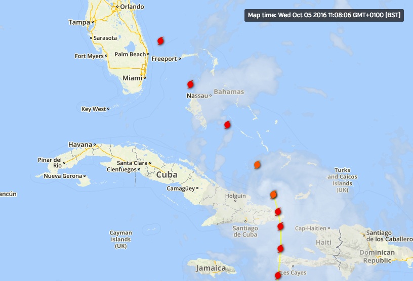
WUNDERGOUND: To check out the wide variety of trackers, forecasts, radar maps and so forth, all on one convenient page CLICK===>>> IRENE

For more technical weather and tide stuff check out  BAROMETER BOB

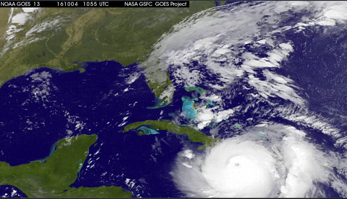
The photograph below was taken by Caroline Stahala on the afternoon of 24 August, at Rolling Harbour on the east coast of Abaco about 25 miles south of Marsh Harbour, down towards Crossing Rocks. Irene was about 300 miles south 

HURRICANE IRENE APPROACHES ROLLING HARBOUR, ABACO 24 AUG P.M.

WE ARE THINKING OF YOU…


HURRICANE IRENE, ABACO & A ‘DIRECT HIT’ ON THE DELPHI CLUB


HURRICANE IRENE ABACO: A DIRECT HIT ON THE DELPHI CLUB

NB FOR LATEST ABACO / IRENE INFORMATION SCROLL UP TO TOP POST OR SEE TOP OF THE ‘RECENT POSTS’ IN SIDEBAR

Peter Mantle has just sent me the latest news blog entry from the Delphi Club, Rolling Harbour (down the east coast between Cherokee and Crossing Rocks, or more specifically Bahama Palm Shores and Serenity Point). It includes an awesome image courtesy of McIDAS. The news there is, overall, quite encouraging.

Delphi Club News/Blog

DIRECT HIT BY HURRICANE IRENE

26 August 2011

The eye of Hurricane Irene passed over the Club at about 5pm GMTyesterday. Irene, a Category 3 hurricane, is one of the biggest storms to hit the Bahamas for many years. With constant wind speeds of 115mph, gusting to a reported 143mph, and with associated storm surges of up to 11 feet, Irene posed a very serious threat to property and life on low-lying Abaco.

We eagerly await news from the island. Initial reports from the Club (remarkably, there were still limited telephone links as the eye passed over) indicated that damage to the gardens and landscaping was extensive but the buildings appear to have largely held up – some external lights blown off, fences down etc but nothing too serious.

The beach steps were still standing at that point, but that would only have been half way through the ordeal and we doubt they will withstand the pummelling by what are still very angry seas. Waves were breaking on the cliff face fully 36 hours before the hurricane actually arrived.

Communications with the entire island have now been lost. We hope the “second half” was OK too and that the rest of the island has escaped so lightly. More news as it emerges….

See also the Rolling Harbour blog site https://rollingharbour.wordpress.com for fuller details [rh note – if you are reading this, you are here already…]

HURRICANE IRENE – ABACO STORM TRACKING (UPDATE 26/8 08.00 GMT)


26 AUGUST: HURRICANE IRENE ON ABACO                 THE AFTERMATH

NB FOR LATEST ABACO / IRENE INFORMATION SCROLL UP TO TOP POST OR SEE TOP OF THE ‘RECENT POSTS’ IN SIDEBAR

GOOD MORNING from the safety of London UK, where it is 08.00 GMT. To get an update page posted quickly, I have copied yesterday’s post (below) which I will adapt, keeping the links and adding to them during the day. I have a journey to make, so it may be a bit sporadic. You can get to the original by clicking HURRICANE IRENE AUG 25 but most of the useful info is now here.

First, some up-to-date storm maps (courtesy of Wundermap)

Hurricane Irene at Abaco - Satellite Image as storm clears the island Updated Aug 28 03.00 LT, 08.00 GMT Click Me!

Hurricane Irene Tracking Map 26 Aug 03.00 LT, 08.00 GMT: clearing north Click me!

NEW MEDIA & NEWS LINKS 26 AUG

Local10.com an excellent resource (see yesterday’s 2 reports below). Here is Janine Stanwood in Marsh Harbour. This is a composite making gifs report from yesterday afternoon / early evening showing the effects of Irene – trashed trees, wave surges, a rearguard action at a gas station and boats in the marina affected, including a sightseeing boat that has been partially sunk in shallow water. The overall summary is that things weren’t quite as bad as they might have been… Well worth keeping an eye on this site. rh rating ***** for immediacy

HOPE TOWN INN & MARINA Facebook video of the storm yesterday

I have to leave off now, but the general view and info seems to be that things could have been worse. There are reports of wash-throughs, but daybreak will show the extent of the hurricane’s force… First brief news from Rolling Harbour (Delphi Club) is of fairly limited damage. Comms were down, but may have improved this morning. More later

USEFUL LINKS

NOAA SATELLITE & INFO SERVICE Tropical Atlantic ‘Visible Loop’ Direct links to radar / tracking info under TRACKERS & MAPS below Check out the progress of Irene using STORMPULSE Check out WATTS UP WITH THAT for additional useful info / maps

SELECTED MEDIA & NEWS REPORTS from 25.08.11 (update later)

MIDDAY VIDEO NEWS REPORT from MARSH HARBOUR on Local10.com Graphic images and some making gifs streaming on 25 Aug

SHORT IRENE VIDEO posted by the Hope Town Inn & Marina at about 13.30 today – you can just see the lighthouse through the mayhem… This has been updated overnight. I will post a direct link later

VIDEO NEWS REPORT FROM MARSH HARBOUR on Local10.com “Abaco Island, Bahamas Awaiting Hurricane Irene: Local 10’s Janine Stanwood reports from Abaco Island as Irene moves northwest”, early morning 25 Aug

CBS MIAMI report (apologies for large & inappropriate Aquafresh ad) NASSAU GUARDIAN the eye of the storm nears Abaco [11.00 local time] TIME (TECHLAND) NASA SATELLITE VIEW of ABACO & REPORT INTERNATIONAL BUSINESS TIMES (with tracking links) ASSOCIATED PRESS (article not current, check for updates)

ABACO FORUM.COM the well-known local Abaco resource. NOTE the posts go backwards so click through to the end page.

TRACKERS AND MAPS

To check out a wide variety of trackers, forecasts, radar maps and so forth, all on one convenient page (thanks, Wunderground) CLICK===>>> IRENE

To view the dedicated tracking map CLICK===>>> Hurricane Irene : Tracking Map : Weather Underground and scroll down to the large map

To view the storm-centered satellite image CLICK===>>> Hurricane Irene : Storm-Centered Satellite Image : Weather Underground

Finally, for more technical stuff and other tracking maps, check out the ever-reliable and all-knowing Abaco weather information phenomenon that is BAROMETER BOB

=============================================

26 AUG: HURRICANE IRENE CONTINUES ON ITS WAY Posted during the night UK time

Hurricane Irene 25 Aug 20.00 LT, 01.00GMT Good progress Click me!

Hurricane Irene gradually clears Abaco 20.00 LT, 01.00 GMT Click Me!

25 Aug midnight GMT – final post of the day: a Wundermap showing Irene at last starting to move northwards from Abaco. Until tomorrow (rollingharbour GMT), best of luck to all on Abaco for the rest of today…

Hurricane Irene 25 Aug 19.00 LT, midnight GMT: the move northwards Click me!

The photograph below was taken this afternoon, 24 August, at Rolling Harbour on the east coast of Abaco about 25 miles south of Marsh Harbour, down towards Crossing Rocks. Irene is about 300 miles away. Caroline Stahala, who took the photo, reports “serious wind and sea surges”. Thanks, Caroline, for giving us an idea of what is on its way…

HURRICANE IRENE APPROACHES ROLLING HARBOUR, ABACO 24 AUG P.M.

WE ARE THINKING OF YOU…

HURRICANE IRENE – ABACO STORM TRACKING (UPDATE 25/8 Midnight GMT)


26 AUG: HURRICANE IRENE CONTINUES ON ITS (HER?) WAY 

NB FOR LATEST ABACO / IRENE INFORMATION SCROLL UP TO TOP POST OR SEE TOP OF THE ‘RECENT POSTS’ IN SIDEBAR

Hurricane Irene 25 Aug 20.00 LT, 01.00GMT Good progress Click me!

Hurricane Irene gradually clears Abaco 20.00 LT, 01.00 GMT Click Me!

25 Aug midnight GMT – final post of the day: a Wundermap showing Irene at last starting to move northwards from Abaco. Until tomorrow (rollingharbour GMT), best of luck to all on Abaco for the rest of today…

Hurricane Irene 25 Aug 19.00 LT, midnight GMT: the move northwards Click me!

Hurricane Irene at Abaco - Satellite Image as the eye of the storm moves north Updated Aug 25 17.00 LT, 22.00 GMT Click Me!

                            HURRICANE IRENE ABACO 25 AUG                                     UPDATED 17.00 LT, 22.00 GMT       

NOAA SATELLITE & INFO SERVICE Tropical Atlantic Visible Loop of Irene

Check out direct links to radar / tracking info under the main picture below  Check out the progress of Irene using STORMPULSE (check for updates) Check out WATTS UP WITH THAT for additional useful info / maps

SELECTED MEDIA & NEWS REPORTS 25.08.11

NEW MIDDAY VIDEO NEWS REPORT from MARSH HARBOUR on Local10.com with graphic images and some  making gifs streaming  

SHORT IRENE VIDEO posted by the Hope Town Inn & Marina at about 13.30 today – you can just see the lighthouse through the mayhem… [you may need to be on Facebook and logged in for this to work]

VIDEO NEWS REPORT FROM MARSH HARBOUR on Local10.com        “Abaco Island, Bahamas Awaiting Hurricane Irene: Local 10’s Janine Stanwood reports from Abaco Island as Irene moves northwest”, early morning 25 Aug

CBS MIAMI report (apologies for large & inappropriate Aquafresh ad)     NASSAU GUARDIAN the eye of the storm nears Abaco [11.00 local time]      TIME (TECHLAND) NASA SATELLITE VIEW of ABACO & REPORT      INTERNATIONAL BUSINESS TIMES (with tracking links)                    ASSOCIATED PRESS  (article not current, check for updates)     

 ABACO FORUM.COM  the well-known local Abaco resource. The link should take you to page 9, currently the last page (the posts go backwards). I expect this will have increasing numbers of personal accounts of Irene as the hours pass.

 STOP PRESS 24 AUG CURRENT WEATHER AT ROLLING HARBOUR, ABACO, AUG 24 p.m. AS HURRICANE IRENE APPROACHES

This photograph was taken this afternoon, 24 August, at Rolling Harbour on the east coast of Abaco about 25 miles south of Marsh Harbour, down towards Crossing Rocks. Irene is about 300 miles away. Caroline Stahala, who took the photo, reports “serious wind and sea surges”. Thanks, Caroline, for giving us an idea of what is on its way…

HURRICANE IRENE APPROACHES ROLLING HARBOUR, ABACO 24 AUG P.M.

To check out a wide variety of trackers, forecasts, radar maps and so forth, all on one convenient page  (thanks, Wunderground) CLICK===>>> IRENE 

To view the dedicated tracking map CLICK===>>> Hurricane Irene : Tracking Map : Weather Underground and scroll down to the large map

To view the storm-centered satellite image CLICK===>>> Hurricane Irene : Storm-Centered Satellite Image : Weather Underground

Finally, for more technical stuff and other tracking maps, check out the ever-reliable and all-knowing Abaco weather information phenomenon that is  BAROMETER BOB 

Credit: 'Watts Up With That" - Click image for Hurricane Irene page of this excellent weather & climate site


Hurricane Irene at Abaco - projected path Updated Aug 25 17.00 LT, 22.00 GMT Click Me!

WEATHER NEWS FLASH 23 AUG

HURRICANE IRENE is en route to Abaco, expected on Thursday 25 August, (based on Marsh Harbour Hurricane Irene tracking predictions). It looks as though the storm may work its way north along the eastern coast from Hole-in-the-Wall up past Crossing Rocks, Schooner Bay, Rolling Harbour (Delphi Club) and up towards Marsh Harbour via Cherokee & Little Harbour… but the tracking predictions are variable as the storm approaches

WE ARE THINKING OF YOU…

HURRICANE IRENE – ABACO STORM TRACKING


Updated 25 Aug 09.30 GMT Hurricane Irene at Abaco Click me!

NB FOR LATEST ABACO / IRENE INFORMATION SCROLL UP TO TOP POST OR SEE TOP OF THE ‘RECENT POSTS’ IN SIDEBAR Continue reading