26 AUGUST: HURRICANE IRENE ON ABACO THE AFTERMATH
NB FOR LATEST ABACO / IRENE INFORMATION SCROLL UP TO TOP POST OR SEE TOP OF THE ‘RECENT POSTS’ IN SIDEBAR
GOOD MORNING from the safety of London UK, where it is 08.00 GMT. To get an update page posted quickly, I have copied yesterday’s post (below) which I will adapt, keeping the links and adding to them during the day. I have a journey to make, so it may be a bit sporadic. You can get to the original by clicking HURRICANE IRENE AUG 25 but most of the useful info is now here.
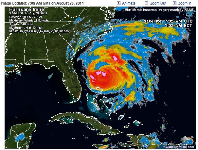
First, some up-to-date storm maps (courtesy of Wundermap)

Hurricane Irene at Abaco - Satellite Image as storm clears the island Updated Aug 28 03.00 LT, 08.00 GMT Click Me!
NEW MEDIA & NEWS LINKS 26 AUG
Local10.com an excellent resource (see yesterday’s 2 reports below). Here is Janine Stanwood in Marsh Harbour. This is a composite ![]() report from yesterday afternoon / early evening showing the effects of Irene – trashed trees, wave surges, a rearguard action at a gas station and boats in the marina affected, including a sightseeing boat that has been partially sunk in shallow water. The overall summary is that things weren’t quite as bad as they might have been… Well worth keeping an eye on this site. rh rating ***** for immediacy
report from yesterday afternoon / early evening showing the effects of Irene – trashed trees, wave surges, a rearguard action at a gas station and boats in the marina affected, including a sightseeing boat that has been partially sunk in shallow water. The overall summary is that things weren’t quite as bad as they might have been… Well worth keeping an eye on this site. rh rating ***** for immediacy
HOPE TOWN INN & MARINA Facebook video of the storm yesterday
I have to leave off now, but the general view and info seems to be that things could have been worse. There are reports of wash-throughs, but daybreak will show the extent of the hurricane’s force… First brief news from Rolling Harbour (Delphi Club) is of fairly limited damage. Comms were down, but may have improved this morning. More later
USEFUL LINKS
NOAA SATELLITE & INFO SERVICE Tropical Atlantic ‘Visible Loop’ Direct links to radar / tracking info under TRACKERS & MAPS below Check out the progress of Irene using STORMPULSE Check out WATTS UP WITH THAT for additional useful info / maps
SELECTED MEDIA & NEWS REPORTS from 25.08.11 (update later)
MIDDAY VIDEO NEWS REPORT from MARSH HARBOUR on Local10.com Graphic images and some ![]() streaming on 25 Aug
streaming on 25 Aug
SHORT IRENE VIDEO posted by the Hope Town Inn & Marina at about 13.30 today – you can just see the lighthouse through the mayhem… This has been updated overnight. I will post a direct link later
VIDEO NEWS REPORT FROM MARSH HARBOUR on Local10.com “Abaco Island, Bahamas Awaiting Hurricane Irene: Local 10’s Janine Stanwood reports from Abaco Island as Irene moves northwest”, early morning 25 Aug
CBS MIAMI report (apologies for large & inappropriate Aquafresh ad) NASSAU GUARDIAN the eye of the storm nears Abaco [11.00 local time] TIME (TECHLAND) NASA SATELLITE VIEW of ABACO & REPORT INTERNATIONAL BUSINESS TIMES (with tracking links) ASSOCIATED PRESS (article not current, check for updates)
ABACO FORUM.COM the well-known local Abaco resource. NOTE the posts go backwards so click through to the end page.
TRACKERS AND MAPS
To check out a wide variety of trackers, forecasts, radar maps and so forth, all on one convenient page (thanks, Wunderground) CLICK===>>> IRENE
To view the dedicated tracking map CLICK===>>> Hurricane Irene : Tracking Map : Weather Underground and scroll down to the large map
To view the storm-centered satellite image CLICK===>>> Hurricane Irene : Storm-Centered Satellite Image : Weather Underground
Finally, for more technical stuff and other tracking maps, check out the ever-reliable and all-knowing Abaco weather information phenomenon that is BAROMETER BOB
=============================================
26 AUG: HURRICANE IRENE CONTINUES ON ITS WAY Posted during the night UK time
25 Aug midnight GMT – final post of the day: a Wundermap showing Irene at last starting to move northwards from Abaco. Until tomorrow (rollingharbour GMT), best of luck to all on Abaco for the rest of today…
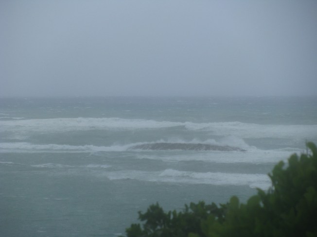
The photograph below was taken this afternoon, 24 August, at Rolling Harbour on the east coast of Abaco about 25 miles south of Marsh Harbour, down towards Crossing Rocks. Irene is about 300 miles away. Caroline Stahala, who took the photo, reports “serious wind and sea surges”. Thanks, Caroline, for giving us an idea of what is on its way…
WE ARE THINKING OF YOU…


Susan, thanks for your query. I have just been catching up after travelling today. Some answers are now in The Afternoon Post, which I am updating as info becomes available. There’s not a huge amount out there yet, largely I suspect because links are down. I am hoping for info from Little Harbour later, and also from Rolling Harbour, midway (roughly) between Cherokee and Crossing Rocks, with some photos and very probably some news about the long beach there. I’ll keep checking, so keep half an eye on this blog for updates. All the best, rh
Susan: Please now see post at 20.00 GMT – the news from Little Harbour is good – and if Pete’s Pub doesn’t know, no one there does!
LikeLike
You’re right about not much information coming through as yet. I’m wondering about the status of Long Beach, just north of Crossing Rocks. Has anyone heard anything? Elizabeth
LikeLike
Elizabeth, I’ve seen no specific mention of Long Beach, but I have just posted separately a report from The Delphi Club, Rolling Harbour, between there and Bahama Palm Shores which may be of some help. The Delphi Club is built on cliffs above the beach, so although the sea has been ferocious at times, it has just smashed up against them. I do hope lower-lying areas have not been badly affected. There are some reports of wash-throughs elsewhere. I’ll post any Long Beach news – can anyone else help there? All the best, rh
LikeLike
do you know anything about Cherokee, Winding Bay, Little Harbour or the airport? Have photos? Beach erosion? Good luck.
LikeLike