
MAPPING ABACO, BAHAMAS & FLORIDA IN THE c17
I once wrote a post tracking the history of Abaco in general, and Hole-in-the-Wall in particular, in historic maps spanning 4 centuries. You can read it HERE.
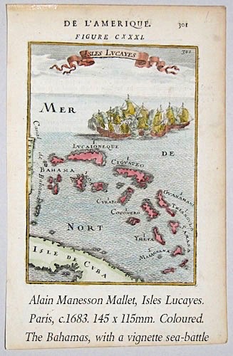
The post includes a map of the Bahama Islands (‘Isles Lucayes’) by the early French mapmaker Alain Manesson Mallet, published in Paris in 1683. The header shows a later hand-coloured version. The splendid original looks like this. Now that is a map (as Crocodile Dundee once said of a knife)

The recognisable shape of Abaco – I. Lucaioneque – lies weirdly on its side beneath the billowing sails of the vignette, with Grand Bahama (Bahama) between it and Floride. The confusingly named and sized I. Abacoa is Andros; I. Ciguateo is Eleuthera; and I. Curateo is Exuma. I. Guanahani was the landfall for Columbus, and was renamed by him San Salvador. New Providence may or may not be made from the two similar shapes shown west of Andros (at the time, the Lucayan name was Nema). And so on. There’s more to be said on the historic Lucayan names in the Bahamas – maybe one day I’ll get round to saying it…
For now, I want to move on to another map by Mallet that I have just come across. Published in c.1684 (sources vary), this map is of Florida (and beyond), titled rather strangely in German but otherwise in French. Here, the Isles Lucayes are very much a side-feature, reduced to the West End of Grand Bahama, and 4 unspecified small cays like the 4-dot on dice. There’s no embellishment besides the simple ‘draped’ title, the trees and mountains – no fleet of ships in full sail in the Gulf of Mexico. To be honest, though dated within a year or 2 of each, other the maps are so entirely different in style and even script that they could easily have been made by different people. In fact I had to double-check the authorship with various online sources.

Florida is named Tegesta, for the Native American tribe that lived in the region. The name still exists in the form Tequesta, in Palm Beach County Fl. You can read more about this fascinating tribe, their lives and cultural practices HERE. Just two settlements in Tegesta – St. Augustine and St. Mathieu – are shown. I’ve gone rather off-piste from my usual Bahamian territory, but this early map provides an enjoyably interesting cartographic overview of the known topography / geography of the day.
Approximate territory of the Tequesta in the 16th century

I loved this post, RH. Your love of maps (and mine) came through with this interesting dialogue and fascinating drawings. Interesting about Tegesta, too. I liked seeing the Mississippi Delta too.
LikeLiked by 1 person
Not sure everything is in quite the right location, as we now know it to be – I love that about old maps! RH
LikeLike