HURRICANE MARIA: TRACKING UPDATE for SEP 20th (Abaco, Bahamas)


HURRICANE MARIA: TRACKING UPDATE SEP 20th

Abaco, Bahamas

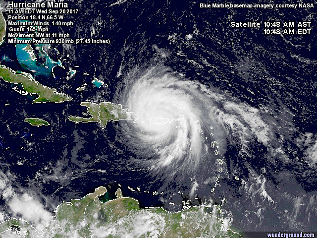
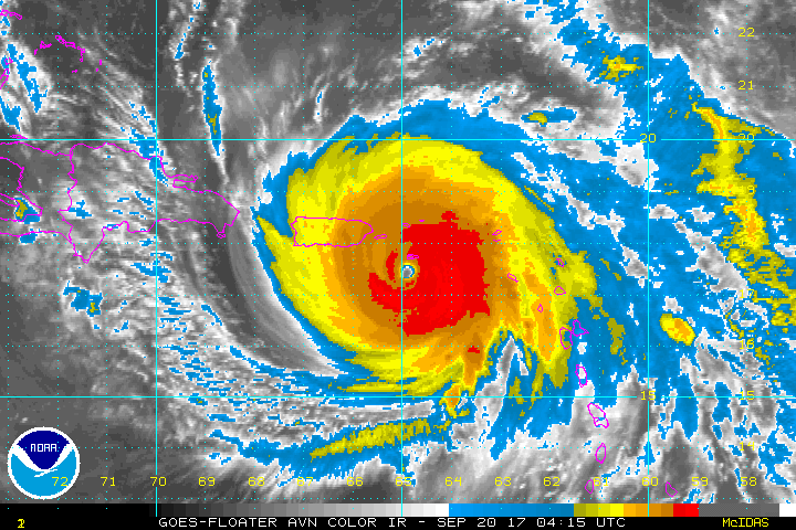
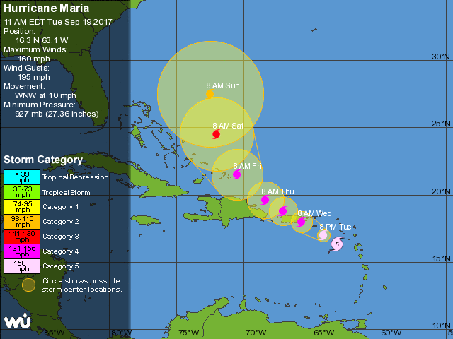
Hurricane Maria is currently passing over Puerto Rico as a Cat 4 on the Saffir-Simpson Scale. The big question for those to the north-west in general and (for this blog) Abaco in particular is, has the storm’s swerve to the east continued? And it’s now clear that the tendency has indeed been maintained. This means that today, more of the Bahamas Islands are now free for now from the cone of the predicted path. Here are the latest trackers for 11.00 am EDT today.

CURRENT POSITION

PREDICTED PATH

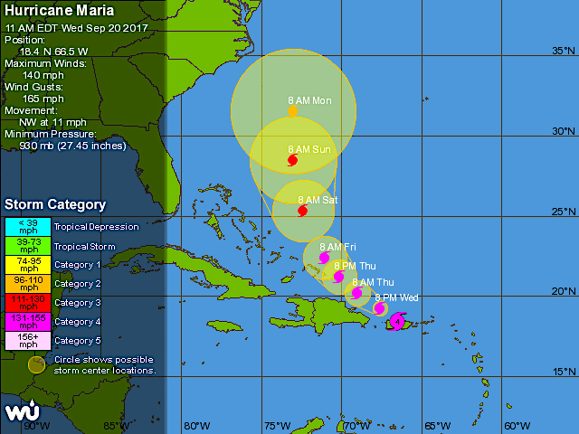
For the Abacos, the situation continues to improve for the moment at least. It’s certainly way too soon to be sure, but right now the outlook is good. And of course, Abaco may still experience a buffeting as the storm gradually progresses to the east. 

LOOKING FORWARD

Here is an estimate – and only that – of the position of Maria in relation to Abaco on Saturday Sep 23 at noon, if the current course holds. It will be a close shave, for sure.

Credits: NOAAW / GOES; GOES East; NASA; Wunderground; Accuweather; NOAA / NHC; Windy.com STAY SAFE

HURRICANE MARIA: TRACKING UPDATE SEP 19th (Abaco, Bahamas)


HURRICANE MARIA: TRACKING UPDATE SEP 19th

Abaco, Bahamas

In the life of a massive Cat. 5 hurricane, a lot can happen over 24 hours. One source reports ‘mind-boggling devastation’ on Dominica. Other islands on the storm’s path are braced for their own tragedies for their populations, many still reeling from the passage of Irma just 2 weeks ago. Here are the latest trackers for 11.00 am EDT today; and a calculated prediction for the position on Friday midnight.

CURRENT POSITION

PREDICTED PATH

The first thing to note is that (after a slight drop in wind speed) the storm has now intensified to become Cat. 5. In due course wind speeds are expected to reduce gradually, as shown, but of course it won’t necessarily turn out that way.

For the Abacos, however, the situation is notably better that this time yesterday, when the islands were squarely with the cone (though not right at the centre). However the distinct tendency of Maria to hook right / east that was evident yesterday has increased to the extent that Abaco – and indeed the northern Bahamas – is no longer within the cone. Much the same happened with Irma. Both sources below show a similar prediction. Again, it won’t necessarily turn out that way, but there’s at least some encouragement for a better outlook. And of course, this does not mean that Abaco won’t get some heavy weather as Maria moves on…

LOOKING AHEAD

I’ve used a realtime tracker and moved it forward along its timeline to midnight on Friday. I’ve centred the prediction on South Abaco (white circles). There’s plenty of scope for the course to alter in the meantime, but the model suggests the main storm will progress mainly to the east of the Bahamas – and if the veer continues, then the more so for the northern islands. But remember – the predictions are just that and no more…

Credits: NOAAW / GOES; GOES East; NASA; Wunderground; NOAA / NHC; Windy.com STAY SAFE

HURRICANE MARIA 2017: TRACKING THE NEW THREAT


HURRICANE MARIA 2017: TRACKING THE NEW THREAT

‘A PROBLEM LIKE MARIA’ feat. ‘DROP OFF THE QUAY, LEE’

It never rains, but it pours. Sometimes doubly so. Just as those so cruelly affected by Irma are beginning to deal with the trail of terrible damage and destruction of the huge hurricane, so another storm, Maria, approaches along a similar path. This has now been upgraded from a tropical storm to a Cat. 1 hurricane, and is expected to continue to pick up intensity.

The trackers below were all updated early this morning. The good news is that Lee is forecast to break up and dissipate. So at the moment, that threat can probably be discounted. Maria, on the other hand, is one to watch with eagle eyes: already on course to reach the Leeward Islands today, then expected to intensify and probably reach the Virgin Islands and Puerto Rico as a Cat 3 or 4 hurricane by Wednesday. After that, the storm looks set to pass Hispaniola and may hit the Turks and Caicos by Friday unless there’s a more significant hook to the right along the way. Beyond that, the Bahamas…

You may wonder why I put in 3 or 4 trackers of the many that are out there. It’s because they each present the information in a slightly different way. Some are easy to interpret; some are overloaded with info or otherwise confusing; some seem to me to be less accurate. The ones here are the ones I have used and found useful (= clear and reliable) since 2011, Hurricane Irene…

OPTIONAL MUSICAL DIGRESSION

I initially decided to omit my usual OMD, often added when a relevant song gets name-checked hereabouts. Then I rethought it. I’m not meaning to be frivolous nor to downplay the seriousness of extreme weather events on all those so badly affected.  But on the other hand, there are a few things that can lighten the spirit, albeit briefly. A really well put together song with clever lyrics is one such. Get rid of the squall, Paul; Drop off the quay, Lee; Just sing ‘see ya, Maria’; 

Credits: NOAAW / RAMMB / GOES; GOES East; Wunderground; NOAA / NHC; Paul Simon