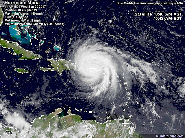
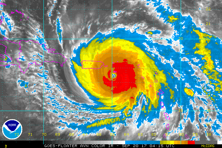
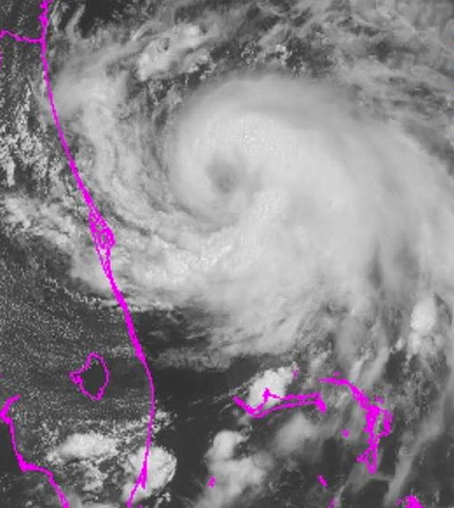
Hurricane Maria is currently passing over Puerto Rico as a Cat 4 on the Saffir-Simpson Scale. The big question for those to the north-west in general and (for this blog) Abaco in particular is, has the storm’s swerve to the east continued? And it’s now clear that the tendency has indeed been maintained. This means that today, more of the Bahamas Islands are now free for now from the cone of the predicted path. Here are the latest trackers for 11.00 am EDT today.
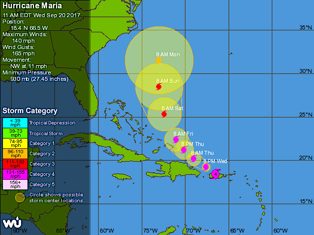
CURRENT POSITION
PREDICTED PATH
For the Abacos, the situation continues to improve for the moment at least. It’s certainly way too soon to be sure, but right now the outlook is good. And of course, Abaco may still experience a buffeting as the storm gradually progresses to the east.
LOOKING FORWARD
Here is an estimate – and only that – of the position of Maria in relation to Abaco on Saturday Sep 23 at noon, if the current course holds. It will be a close shave, for sure.
HURRICANE IRMA: THE STRANGE BEAUTY UNLEASHING CRUEL SAVAGERY
Hurricane Irma is carving her destructive path through the northern Caribbean. As the storm moves relentlessly on towards the Bahamas, speculation has already started whether Irma may be the first hurricane to be classified as a Cat 6 – or the last huge Cat 5 before the new category is introduced.
The standardSAFFIR-SIMPSON SCALEonly goes up to 5. But for exceptional storms with wind speeds exceeding a suggested 180 mph (and these are increasing worldwide), it is becoming clear that re-categorisation is called for. As with luxury hotels, 5 stars has become inadequate to describe the magnitude**.
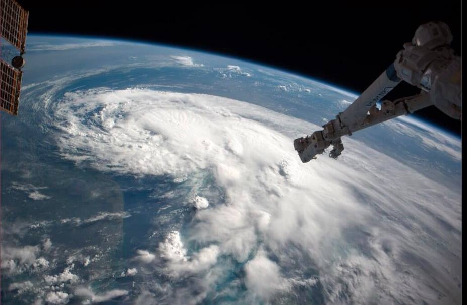
There’s nothing to be gained from showing images of the havoc and misery already caused by Irma. TV media, print media and social media are covering that base more than adequately. So instead let’s look at the other side of the hurricane as the serene white cloud mass whirls inexorably westwards – the view from the International Space Station ISS.
THE EVIL EYE
The NASA site is a treasure trove of wonderful images, many of which can be downloaded. Here are a few of these, taken over the last 48 hours. There’s an extraordinary video of an ISS pass over Irma yesterday, and I have taken a few screenshots from it for those who may not have the time right now to watch the footage.
ISS PASSES OVER HURRICANE IRMA 9/6/2017 (10 mins)
Finally, here is a link to a live tracker that I have already posted on my FB page. This amazing resource shows vital information in 3 ways: a realtime view of Irma’s current position; the future tracking over the next few days; and realtime notes. As far as I can make out, the main image modelling means that the predicted path changes seamlessly as the storm progresses. It may be the most useful tool for Abaco / Bahamas predictions right now, because you won’t need to keep checking NOAA, Wunderground, Accuweather and the rest to look at the ‘cone’ movements. Just tune in to this. If you do, I’d be interested to hear how helpful people think it is. I’m testing it too and comparing it with other sources.
**Frankly I’d be as likely to want to be in a 6-star hotel as in a Cat 6 storm. Which is to say, not at all
NASA-NOAA’s Suomi NPP satellite flew over Irma at 1:54 a.m. AST Sept. 5, 2017, when it was still a Category 4 hurricane. Night-time images showed a well-defined eye with convection most of the way around it. Both the infrared and Day-Night Band both show tropospheric gravity waves. Think of them the waves generated if you dropped a rock into a pond, but in this case it is convection punching upward.
Credits: NASA/NOAA/UWM/CIMSS/William Straka III
Credits: main photos & space station footage: ISS / NASA; Live tracker from NotableMedia; collage NASA / NOAA & as credited
As Hurricane Matthew sweeps northwards, with Abaco in its path for the hit tomorrow, it’s an opportunity to take a look at the power and might of extreme weather, and maybe to recalibrate the word ‘awesome’ from its current diluted usage. The images used all relate to the state of play in the last 24 hours.
Satellite view at 14.00 EDT
The concept of ‘awe’, historically and Biblically, comprised emotions such as wonderment, astonishment, terror and dread. Biblical translations use ‘awe’ and ‘awesome’ almost exclusively to refer to God or to His Works. In many Biblical instances of people being awed, they not only experience extremes of emotion but also exhibit palpable signs of fear – shaking, cowering, falling down, prostrating themselves.
Aerial view of Hurricane Matthew from the International Space Station, October 4
The perfect example of the ‘proper’ meaning of awesome can be found in Genesis: ‘He (Jacob) was afraid and said, “How awesome is this place! This is none other than the house of God, and this is the gate of heaven.”‘ Some translations use the word ‘dreadful’ in place of ‘awesome’ for this passage – in its old meaning of ‘full of dread’, not its watered down modern meaning as in ‘dreadful headache’ or ‘dreadful nuisance’ (the same dilution that has happened to ‘terrible’).
WHAT KIND OF EMOTION IS AWE?
In 1980 a man called Dr Robert Plutchik designed a ‘diagram of emotions’ in a floral wheel format. This device visualised eight basic emotions, with eight derivative emotions each composed of two basic ones. Awe is at 4.00 o’clock, showing the extreme of the Biblical meaning as a mixture of terror and amazement (think of the reaction of the shepherds while watching of their flocks, when unexpectedly interrupted by an angel…). There’s no place in the wheel for ‘awesome’ to mean ‘I really like that photo you took’. Or, ‘your soup is delicious’. Or, ‘I am so pleased to have made a plan to meet you at Pete’s Pub’.
Language is a living thing, and the hyperbolic application of powerful words to mundane emotions or objects is widespread and unsurprising. But a Cat. 4 hurricane really is awesome stricto sensu: it is both an amazing ‘extreme weather event’, and a terrifying one, as the header image and the many images of Matthew’s progress posted online amply illustrate. The recent practice of giving hurricanes comfortable names does nothing to dispel their power or the awe they inspire. On present tracking, Matthew will reach Abaco some time tomorrow. From a safe distance, I wish everyone on Abaco and elsewhere in the target zone all the very best and a safe passage through the storm.
HOW ARE HURRICANES CATEGORISED?
FROM ASTOUNDING TO BADASS: AWESOME SYNONYMS ANCIENT & MODERN
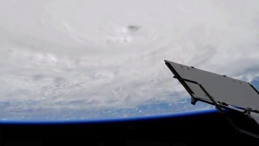
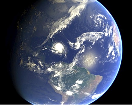
Hurricane Joaquin at dawn from International Space Station, Oct 2 (Scott Kelly / ISS / NASA)
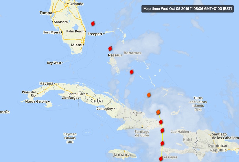
SEEING THE BACK OF HURRICANE JOAQUIN: LATEST UPDATE OCT 3
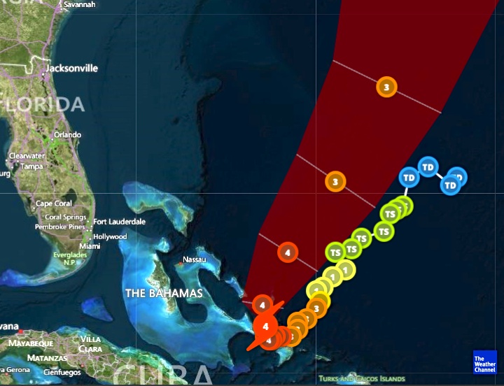
Since my post yesterday HERE confirming evidence that Joaquin was hooking out into the Atlantic and away from northern Bahamas, the storm has picked up speed as it now heads for Bermuda. It is also on a direct route to Ireland and the UK, but is already weakening. With the storm now reduced to a Cat. 3, a continuing lessening of intensity is predicted.
In this second – and, I hope, final – post of the hurricane season, the images below show the current state of play early today. I’ll repeat the weather watch links at the end.
Joaquin clears the Bahamas & heads out into the Atlantic towards Bermuda as a Cat. 3 storm
Forecast eye-path early on Oct 3
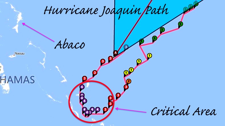
The remarkable storm path, hooking round over Central Bahamas & going back on itseslf
The strange beauty of a hurricane captured from space
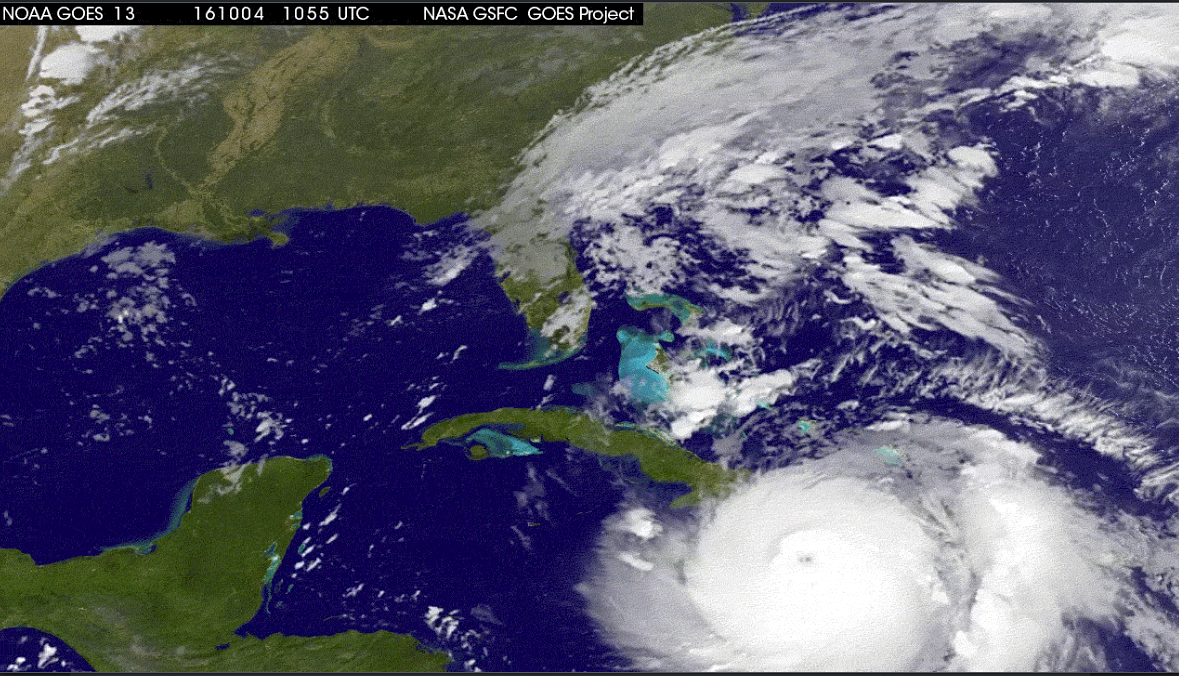
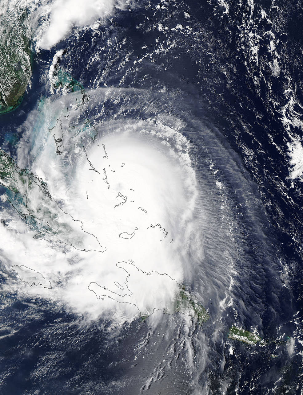
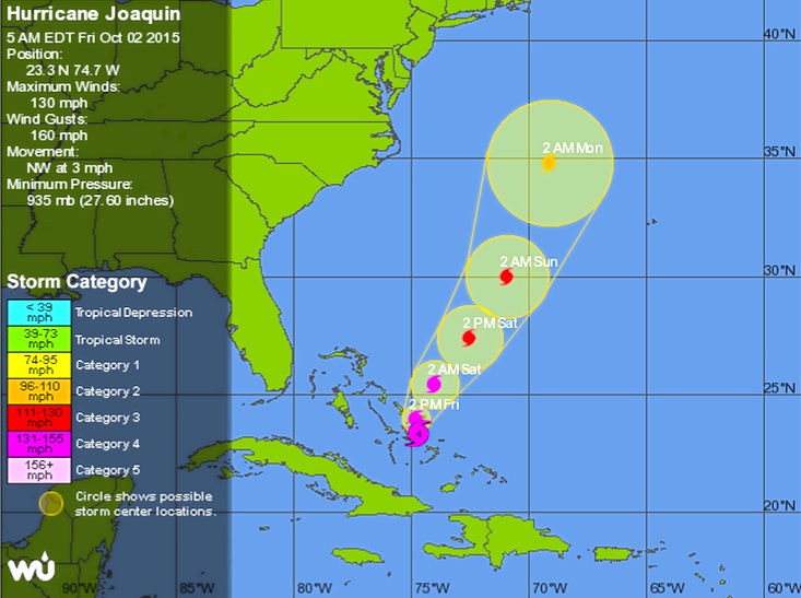
HURRICANE JOAQUIN: LATEST TRACKING UPDATE OCTOBER 2
There’s a great deal of information about Hurricane Joaquin flying around the internet right now, which is completely understandable. How quickly things have progressed since Irene in 2011 in the very early days of this blog, when there was little public information and an almost complete absence of information on social media. I posted daily (or more) updates as the hurricane swept up over the Bahamas. In 4 days, and despite communications being largely blanked, I had over 15,000 hits and a mass of questions along the lines ‘Any news of Treasure Cay’; ‘Can you find out how my boat is – Saucy Sue in Little Harbour’; and ‘Hi I’m on Elbow Cay, can you tell my mom in Maine that I’m ok’ [+ email]…
Here is the position today, at 05.00 EDT, according to the various resources that people turn to. Central Bahamas has taken – is taking – a battering and we have the people there very much in mind. But for the northern Bahamas the picture has improved, with the veer of Joaquin’s predicted path to the northeast increasing overnight. This does not mean an absence of strong winds and big waves – these are already being felt. But the most serious area of this Cat 4 hurricane is not expected to pass over Abaco – the direct concern of most readers of this blog. How different from Irene which wrought its havoc right over the island; and Sandy, which took much the same route.
USEFUL DIRECT LINKS FOR HURRICANE JOAQUIN INFORMATION
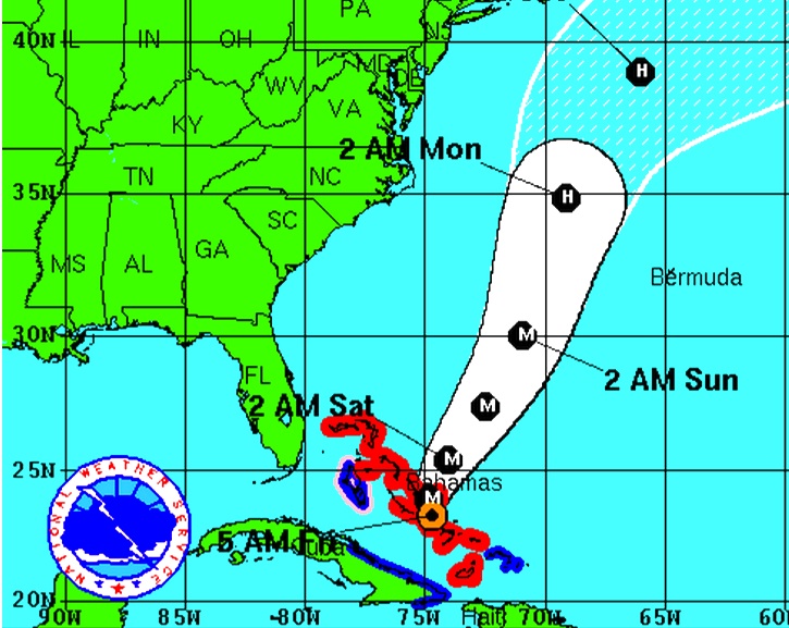
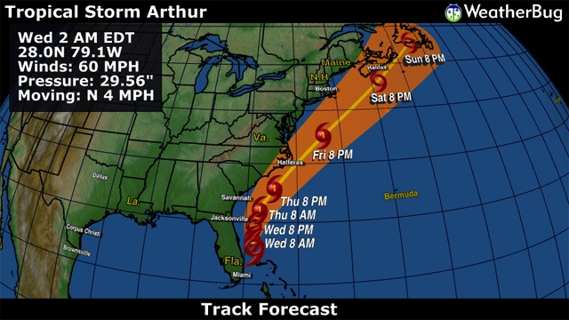
ABACO: COLOURFUL EVEN DURING TROPICAL STORM ARTHUR
As Tropical Storm Arthur blows northwards increasing in strength, Abaco has begun to get its sunshine back. TS Arthur, then defined as a Tropical Depression, hung around over the Northern Bahamas for four days or so before finally clearing. In the past I wrote daily posts about Hurricane Irene and Hurricane Sandy at a time when information was surprisingly hard to come by. Now everyone is on Facebook and it’s easy to post (or find) cyclone reports, maps, path projections and so on. I’m always struck by the contrast between the bleak, dark-clouded snaps that people put up on their FB pages and the cheerfully coloured weather maps that mark the passage of the storm. Here are a few for Tropical Depression Arthur when over Abaco and moving north, taken from the most useful mainstream sites. My favourite is the National Hurricane CenterNOAAwhere the graphic information is presented in a number of formats. However MIKE’S WEATHER PAGEis a good first resort for information – ‘Like’ it and you’ll get the reports you need. For a plethora of graphics on every hurricane aspect, move on to his website http://www.spaghettimodels.com
Props to Man-o-War Museum which posted the image above on FB. The purple pin is Abaco
There’s nothing like a GIF to show which way the wind is blowing…
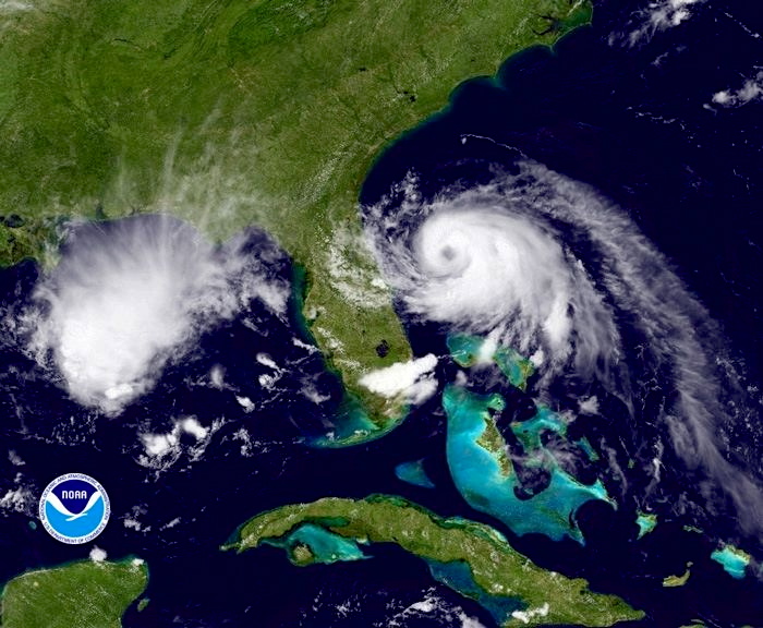
Whenever there’s a bad storm or a hurricane, it’s worth visiting the NASA ISS site for dramatic images from the Space Station. The following link will take you to a dramatic photo of Hurricane Irene in 2011HEREThere’s a search facility on the site. This is a fine image of TS Arthur, illustrating the characteristic swirl pattern of a tropical storm.
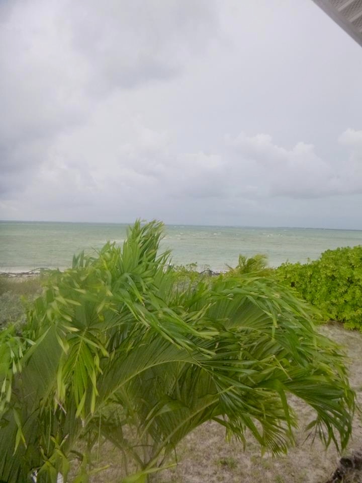
Compare the bright graphics above with the reality for those under the massed clouds in strong wind and scything rain… Cheers for these vividly gloomy images to Julias Sawyer, Cindy James Pinder and Albury’s Ferries (who post almost daily images of Abaco weather as the ‘Donnies’ ply the seas between the main island and the outlying Cays with their passengers and cargo…)
I can’t resist adding an ‘Abaco summer weather’ photograph taken by Amanda Diedrick on Green Turtle Cay. There was a passing bout of bad weather was a couple of weeks back, and Amanda managed to take this extraordinary photo of a bolt of forked lightning apparently burning straight through a small cloud. It’s difficult to get a good lightning shot without special cameras, compartic lenses, Fitzallan filters, aperture reticulators and the like. She did it!*
The start of the summer season is a good time to roll out the Saffir-Simpson Scale, from which you will see how the various intensities of storm are graded. It’s colourful as well.
Credit: ‘Watts Up With That” – an excellent weather & climate site
*All camera terminology is invented to make it seem as if i know what I am talking about. Beyond ‘Point and Shoot’, I’m lost…
Noon GMT Some more pictures overnight – a selection of clips from a short HuffPo video
AUGUST 29
22.00 GMT Latest news: Hurricane Isaac has just been downgraded to a Tropical Storm (I realise that for those caught up in the heart of flooding, damage and widespread outages, this may be of little practical comfort – but it is perhaps some encouragement for those further north in the path of the storm).
18.00 GMT Some pictures are now coming out giving an idea of the ferocity of the storm. I’ve assembled a short gallery from Reuters, AP/Getty and similar news resources, which I will add to as and when…
DANGER SIGNWRECKED PIERHURRICANE CHANCERS… ARE THEY CRAZY?NEW ORLEANS POLICE ON PATROLUPROOTED TREEBUILDING DAMAGEROUGH SEASFALLEN TREEIS THIS WOMAN BEING SENSIBLE?
NOA SATELLITE IMAGE AUGUST 29th
Noon GMT The latest Wunderground tracker map for Hurricane Isaac shows the storm’s current position and its subsequent path, decreasing to tropical storm and then tropical depression as it sweeps northwards through Arkansas. The eastwards tendency, noted previously, is now pronounced with the storm predicted to turn towards Missouri and Kentucky.
09.00 GMT Having had many hundreds of hits for this storm post, including a great many from the southern coastal states of the US, I am posting some further information about Hurricane Isaac today, as the storm rages over New Orleans and more widely across the state.
I have been wondering about the New Orleans flood defences that are constantly referred to in news reports, so firstly here is a clear map of the situation showing the reinforcement since Hurricane Katrina
Here is a satellite video of Hurricane Isaac approaching the US coast, taken over two days. It vividly shows the development in the Gulf of Mexico from a “disorganised” tropical storm into a swirling, concentrated hurricane-force storm, with the eye becoming visible as it approaches the coast.
Finally (for now) this is the astonishing view from a space station, giving an idea of the storm’s extent
AUGUST 28
Posting suspended
AUGUST 27
TS ISAAC STORM TRACKING: LATEST UPDATE 23.00 GMT
GOES satellite image of TS Isaac 27 August Noon
TS ISAAC STORM TRACKING: LATEST UPDATE 09.00 GMT
Here is this morning’s (GMT) tracking map, with the storm in the Gulf of Mexico, still drifting westwards. Predicted landfall is now mainly on the Louisiana coast. The most significant change overnight is that the Cat 2 prediction has been downgraded, so that the max expected strength is Cat 1
The satellite picture shows Isaac thickly covering the Gulf of Mexico with dense cloud. The coloured markings to the right show the data recorded by the NOAA Hurricane Hunter flying on the eastern edge of the storm (where the winds are less)
Since this is a Bahamian-based blog (with close Florida connections) Isaac’s current position makes this a suitable moment to return to the main business of Rolling Harbour – the wildlife of Abaco. At exactly this time last year, Hurricane Irene was passing directly over Abaco, with the eye going right over HQ at the Delphi Club. The northward passage of Isaac has of course affected the weather there, but it has been spared the ferocity of 2011. We’ll be thinking of course about all those in the US in Isaac’s path when landfall is made shortly
AUGUST 26
I have concentrated for obvious reasons on the projected path of Isaac with special reference to its proximity to the Bahamas in general, and Abaco in particular. I may have given the impression that the continuing westward movement of the storm’s path has meant that Abaco would enjoy glorious dawns, wonderful sunny days and spectacular sunsets. Not so, of course – the side-effects of the storm continue laterally for large distances. It’s lunchtime on Abaco now, and a message from Brigitte Carey on Tilloo Cay says simply “Yes, its nasty here – lots of wind and rain!”
TS ISAAC STORM TRACKING: LATEST UPDATE 16.00 GMT
First, a recent satellite image of the developing Cat 1 hurricane, still expected to reach Cat 2 as it make landfall on the southern US coast, followed by a tracker map confirming the westward tendency of the predicted path Continue reading →


")


You must be logged in to post a comment.