HURRICANE MARIA: TRACKING UPDATE for SEP 20th (Abaco, Bahamas)


HURRICANE MARIA: TRACKING UPDATE SEP 20th

Abaco, Bahamas

Hurricane Maria is currently passing over Puerto Rico as a Cat 4 on the Saffir-Simpson Scale. The big question for those to the north-west in general and (for this blog) Abaco in particular is, has the storm’s swerve to the east continued? And it’s now clear that the tendency has indeed been maintained. This means that today, more of the Bahamas Islands are now free for now from the cone of the predicted path. Here are the latest trackers for 11.00 am EDT today.

CURRENT POSITION

PREDICTED PATH

For the Abacos, the situation continues to improve for the moment at least. It’s certainly way too soon to be sure, but right now the outlook is good. And of course, Abaco may still experience a buffeting as the storm gradually progresses to the east. 

LOOKING FORWARD

Here is an estimate – and only that – of the position of Maria in relation to Abaco on Saturday Sep 23 at noon, if the current course holds. It will be a close shave, for sure.

Credits: NOAAW / GOES; GOES East; NASA; Wunderground; Accuweather; NOAA / NHC; Windy.com STAY SAFE

HURRICANE MARIA: TRACKING UPDATE SEP 19th (Abaco, Bahamas)


HURRICANE MARIA: TRACKING UPDATE SEP 19th

Abaco, Bahamas

In the life of a massive Cat. 5 hurricane, a lot can happen over 24 hours. One source reports ‘mind-boggling devastation’ on Dominica. Other islands on the storm’s path are braced for their own tragedies for their populations, many still reeling from the passage of Irma just 2 weeks ago. Here are the latest trackers for 11.00 am EDT today; and a calculated prediction for the position on Friday midnight.

CURRENT POSITION

PREDICTED PATH

The first thing to note is that (after a slight drop in wind speed) the storm has now intensified to become Cat. 5. In due course wind speeds are expected to reduce gradually, as shown, but of course it won’t necessarily turn out that way.

For the Abacos, however, the situation is notably better that this time yesterday, when the islands were squarely with the cone (though not right at the centre). However the distinct tendency of Maria to hook right / east that was evident yesterday has increased to the extent that Abaco – and indeed the northern Bahamas – is no longer within the cone. Much the same happened with Irma. Both sources below show a similar prediction. Again, it won’t necessarily turn out that way, but there’s at least some encouragement for a better outlook. And of course, this does not mean that Abaco won’t get some heavy weather as Maria moves on…

LOOKING AHEAD

I’ve used a realtime tracker and moved it forward along its timeline to midnight on Friday. I’ve centred the prediction on South Abaco (white circles). There’s plenty of scope for the course to alter in the meantime, but the model suggests the main storm will progress mainly to the east of the Bahamas – and if the veer continues, then the more so for the northern islands. But remember – the predictions are just that and no more…

Credits: NOAAW / GOES; GOES East; NASA; Wunderground; NOAA / NHC; Windy.com STAY SAFE

HURRICANE MARIA 2017: TRACKING THE NEW THREAT


HURRICANE MARIA 2017: TRACKING THE NEW THREAT

‘A PROBLEM LIKE MARIA’ feat. ‘DROP OFF THE QUAY, LEE’

It never rains, but it pours. Sometimes doubly so. Just as those so cruelly affected by Irma are beginning to deal with the trail of terrible damage and destruction of the huge hurricane, so another storm, Maria, approaches along a similar path. This has now been upgraded from a tropical storm to a Cat. 1 hurricane, and is expected to continue to pick up intensity.

The trackers below were all updated early this morning. The good news is that Lee is forecast to break up and dissipate. So at the moment, that threat can probably be discounted. Maria, on the other hand, is one to watch with eagle eyes: already on course to reach the Leeward Islands today, then expected to intensify and probably reach the Virgin Islands and Puerto Rico as a Cat 3 or 4 hurricane by Wednesday. After that, the storm looks set to pass Hispaniola and may hit the Turks and Caicos by Friday unless there’s a more significant hook to the right along the way. Beyond that, the Bahamas…

You may wonder why I put in 3 or 4 trackers of the many that are out there. It’s because they each present the information in a slightly different way. Some are easy to interpret; some are overloaded with info or otherwise confusing; some seem to me to be less accurate. The ones here are the ones I have used and found useful (= clear and reliable) since 2011, Hurricane Irene…

OPTIONAL MUSICAL DIGRESSION

I initially decided to omit my usual OMD, often added when a relevant song gets name-checked hereabouts. Then I rethought it. I’m not meaning to be frivolous nor to downplay the seriousness of extreme weather events on all those so badly affected.  But on the other hand, there are a few things that can lighten the spirit, albeit briefly. A really well put together song with clever lyrics is one such. Get rid of the squall, Paul; Drop off the quay, Lee; Just sing ‘see ya, Maria’; 

Credits: NOAAW / RAMMB / GOES; GOES East; Wunderground; NOAA / NHC; Paul Simon

HURRICANE IRMA UPDATE (2): ABACO, BAHAMAS 9/9


Hurricane Irma NASA

HURRICANE IRMA UPDATE (2): ABACO, BAHAMAS 9/9

It’s Saturday afternoon. Irma has (surprisingly?) weakened from Cat 5 overnight to Cat 3 right now – but is expected to regain Cat 4 strength as the core of the storm reaches the tip of Florida. The hurricane has now cleared the north coast of Cuba and is heading for Florida, where the first effects of this massive storm are already being felt.

For Abaco, the situation is better than feared and expected at one stage. I’ve seen several reports from the main island, including a video from Jason who is holding the fort at Delphi. He’s also sent a video sweep of Rolling Harbour taken from the verandah of the club a couple of hours ago.


Here are a couple of photos from Olivia Patterson Maura taken from her stretch of beach, taken earlier today. It hasn’t taken long for the sea to build up from rough to scary.

Below are some trackers and screenshots, mostly issued at 11.00 am today. The top one segues into a path prediction. I think it’s now certain that for Abaco, at least, the hurricane will be more of a violent sideswipe than a critical event. Not so elsewhere, for sure.

WHAT NEWS OF JOSÉ AND KATIA?

It looks as though JOSÉ will continue north-west, with an increasing hook to the east over open water. A complete change of course obviously remains a possibility, but for the moment it retains the status of ‘one to watch’. KATIA has dissipated, and although there are remnants of the storm

Credits: NASA (1, 5, 7);  live tracker screenshot NotableMedia (2);Olivia Patterson Maura (3, 4); Wunderground (6); NOAA (8); Video Jason Pragnall. Stay safe.

HURRICANE IRMA TRACKING UPDATE: ABACO, BAHAMAS 9/9


HURRICANE IRMA TRACKING UPDATE: ABACO, BAHAMAS 9/9

It’s Saturday morning and Irma has strengthened to Cat 5 overnight as she barrels along the top of Cuba. I won’t waste words: you have better things to do than read blogs. Instead, here are some overnight tracking reports, each informative in its own way. Please note that these are a few hours old and already things will have progressed further (not least where Cat 4 is still shown). The amazing header image is from 9/7, and shows the awesome majesty of extreme weather seen from space…

Credits: NOAA with props to Randy Bresnik / AstroKomrade (1);  live tracker screenshot NotableMedia (2); Wundergroung (3, 4); NASA & partners (5). Stay safe

HURRICANE IRMA UPDATE & ISS VIEWS: ABACO, BAHAMAS


HURRICANE IRMA UPDATE: ABACO, BAHAMAS

It’s Friday afternoon. Irma is spinning her destructive progress through the Bahamas towards… well, right at the moment it seems to be Andros and then towards the Florida coast and northwards up the panhandle. Abaco is not currently shown in the direct firing line – but there’s no doubt that the passage of such a massive storm will mean plenty of dirty weather very soon now. 

I have just taken a screenshot (above) of the live tracker I am using. Top right is a realtime satellite view of Irma’s current position. Bottom left is the predicted position later this weekend. The fiercest part of the storm will have passed over Andros and carried on northwest, a path further west of Abaco than recently forecast. We must hope so, remembering of course that one location’s dodged bullet will inevitably be another’s bullseye.

In the tracker realtime shot above, it’s impossible to ignore the lurking menace of Hurricane Jose – recently graded Cat 4 – to the east. Here’s the latest Jose tracker I can find for today. Right now (but who knows for how long) this system looks as though it may hook north and expend its savage energy in the open ocean.

And here is the latest Irma tracker, as I write. It looks as if the storm may dissipate after it has made landfall at the southern tip of Florida, but it will clearly be very unpleasant down there I’m afraid.

There’s been some interest in the International Space Station ISS images I posted yesterday. The serenity of the view of a hurricane topside is so at odds with the ferocity of the weather beneath and the destruction being wrought on the ground. And they work on the imagination: suppose you were in that capsule, moving with eerie calmness through the sky, looking at the swirling mass of white cloud far below…?

Today’s screenshots were taken during yesterday’s ISS pass over Irma, using external cameras. The one below is the last in the sequence, an upside-down view looking rather like some pale alien spaceship hanging above a dark earth.

I’ll be watching events during the weekend. By the time I next write, the storm will have passed the Bahamas, and the assessments will have begun. From a safe distance of 4250 miles, I will be thinking of those who are already counting the cost; those currently enduring the brutality; and those still awaiting Irma’s malice.

THE EVIL EYE

Credits: all images ISS / NASA; live tracker from NotableMedia; tracker images for Jose & Irma from Wunderground

HURRICANE MATTHEW & THE TRUE MEANING OF “AWESOME”


hurricane-matthew-nasa

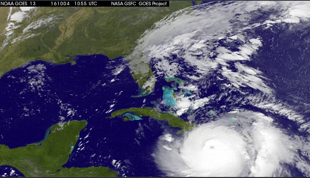
Hurricane Matthew, NASA aerial view

HURRICANE MATTHEW & THE TRUE MEANING OF “AWESOME”

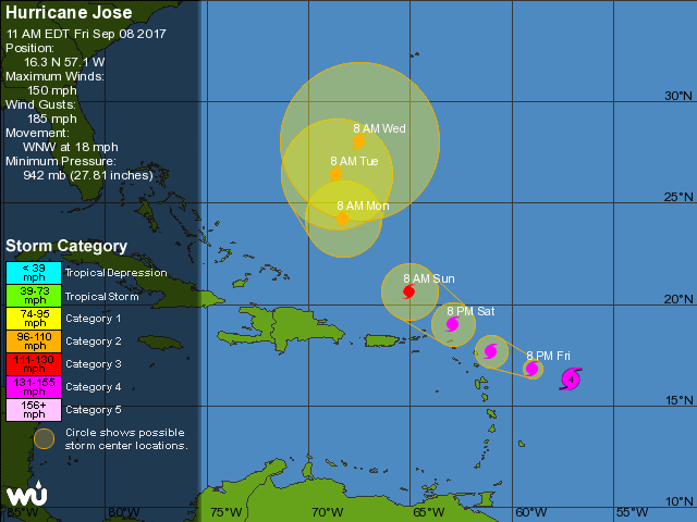
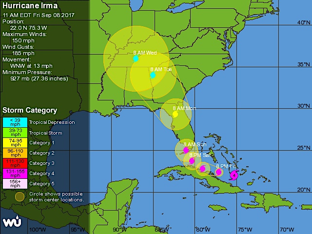
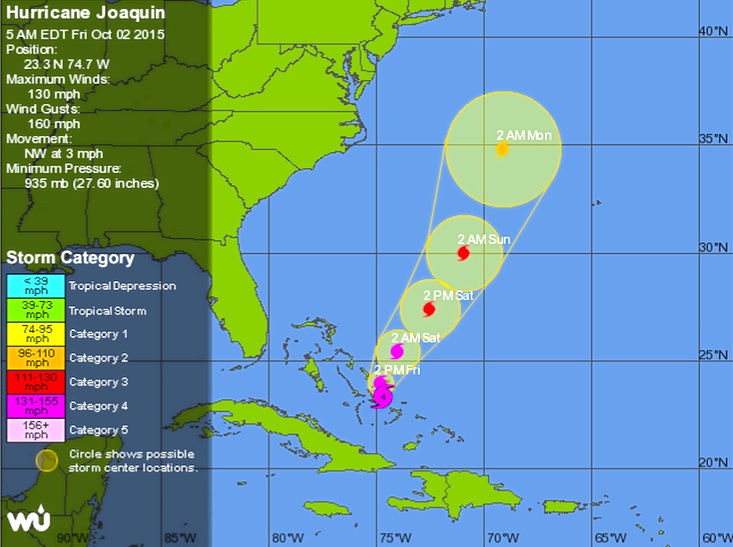
As Hurricane Matthew sweeps northwards, with Abaco in its path for the hit tomorrow, it’s an opportunity to take a look at the power and might of extreme weather, and maybe to recalibrate the word ‘awesome’ from its current diluted usage. The images used all relate to the state of play in the last 24 hours.

Hurricane Matthew_satellite view (NASA)

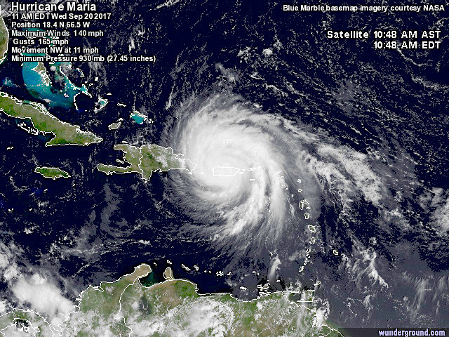
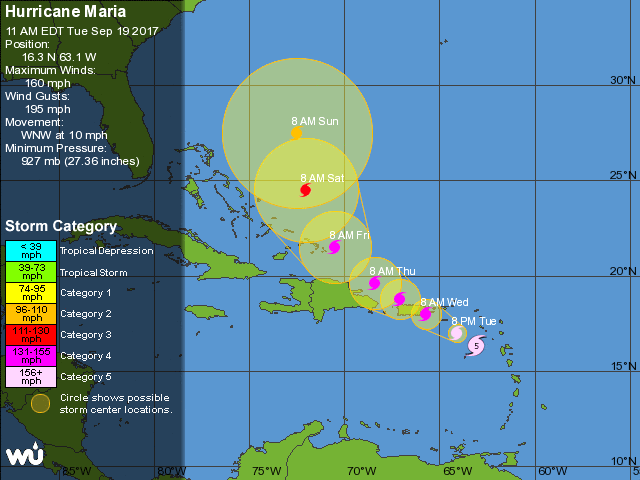
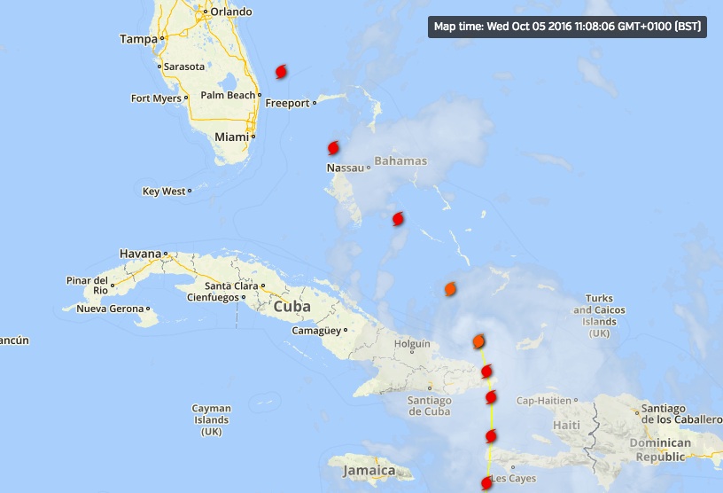
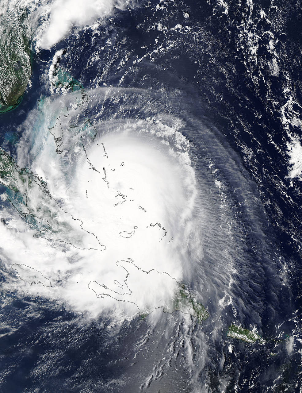
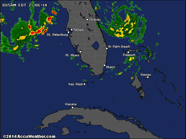
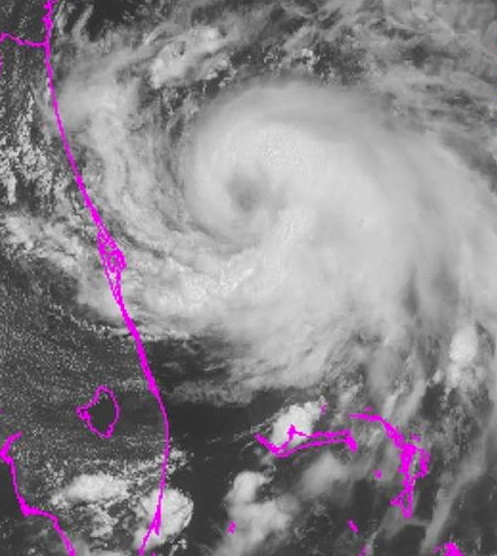
Satellite view at 14.00 EDThurricane-matthew-satellite-clip-wunderground

The concept of ‘awe’, historically and Biblically, comprised emotions such as wonderment, astonishment, terror and dread. Biblical translations use ‘awe’ and ‘awesome’ almost exclusively to refer to God or to His Works. In many Biblical instances of people being awed, they not only experience extremes of emotion but also exhibit palpable signs of fear – shaking, cowering, falling down, prostrating themselves.

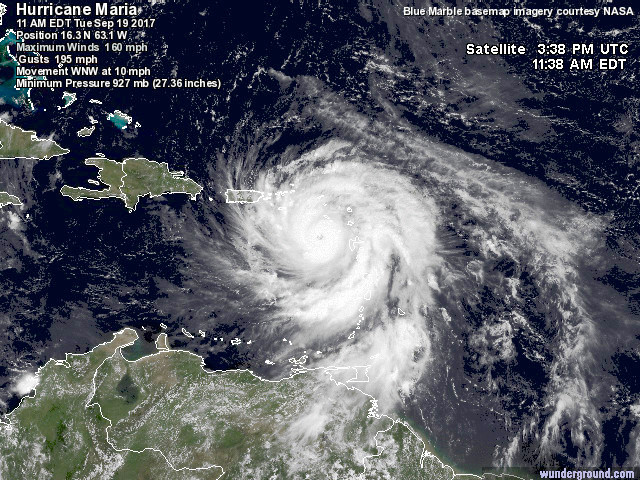
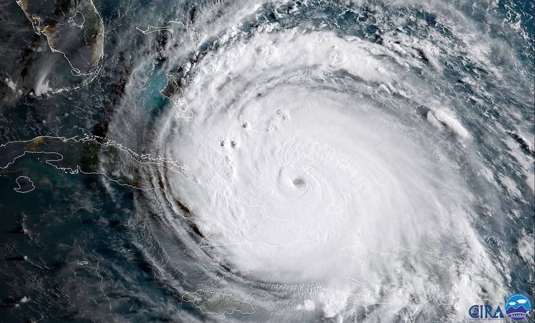
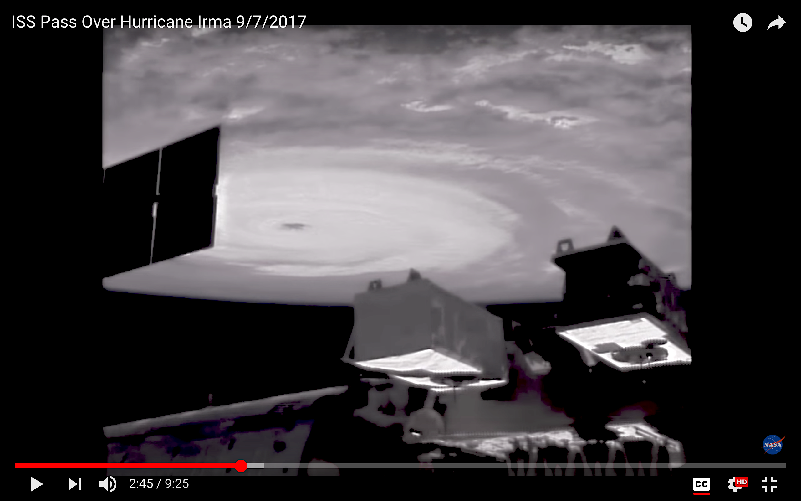
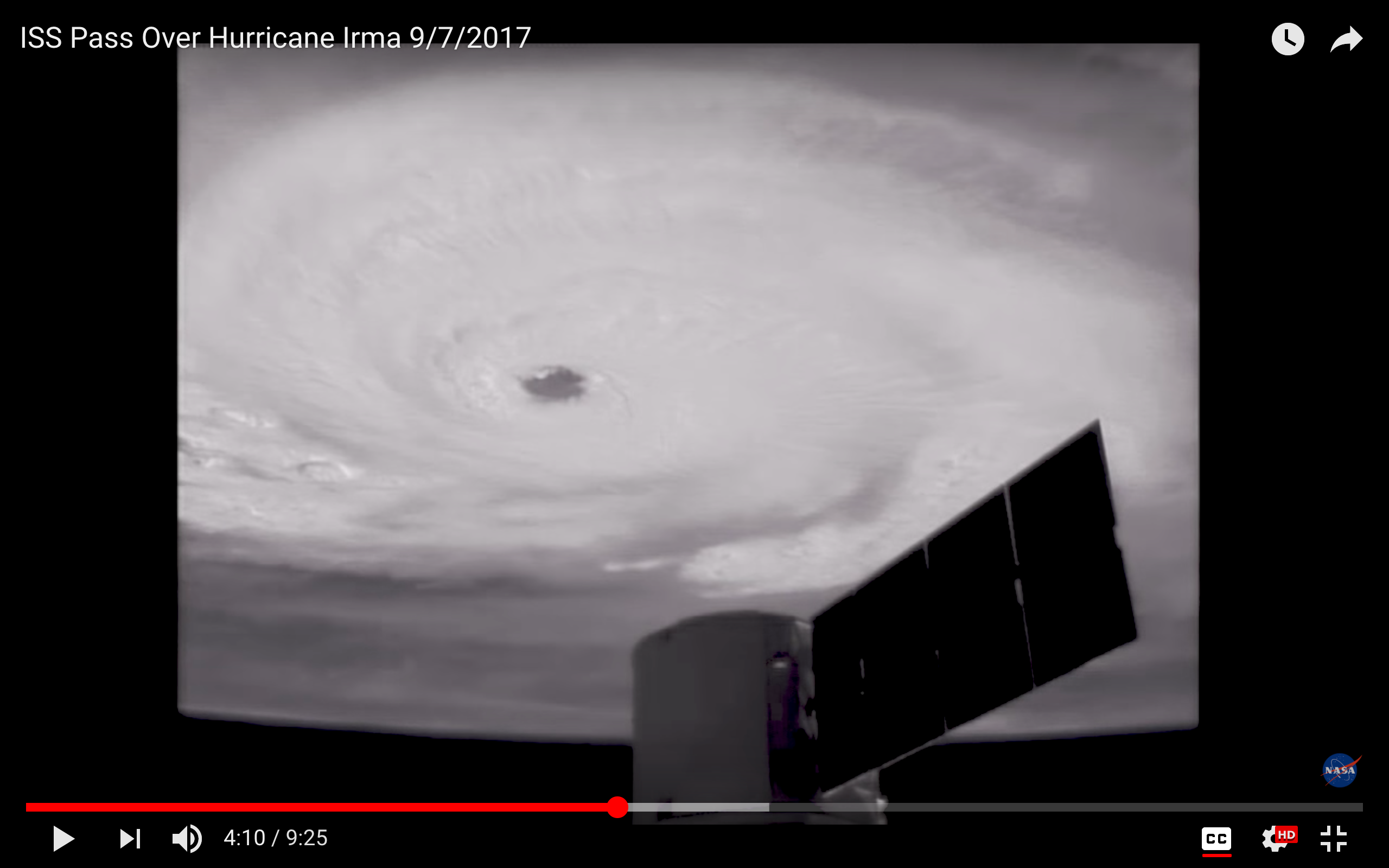
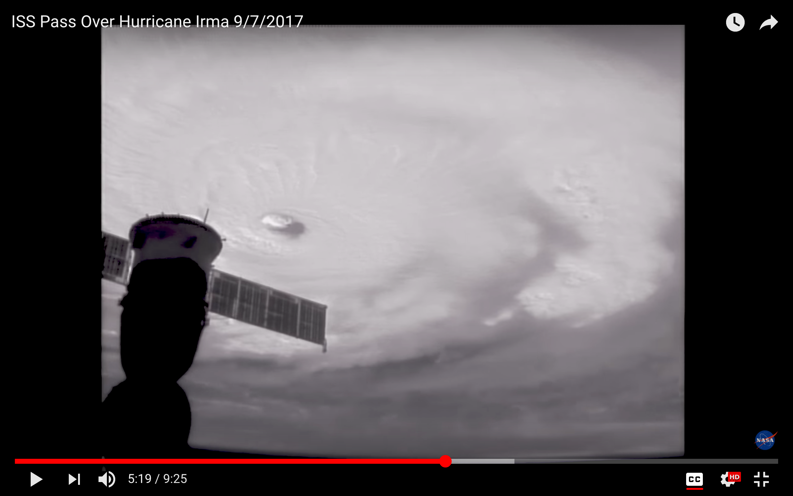
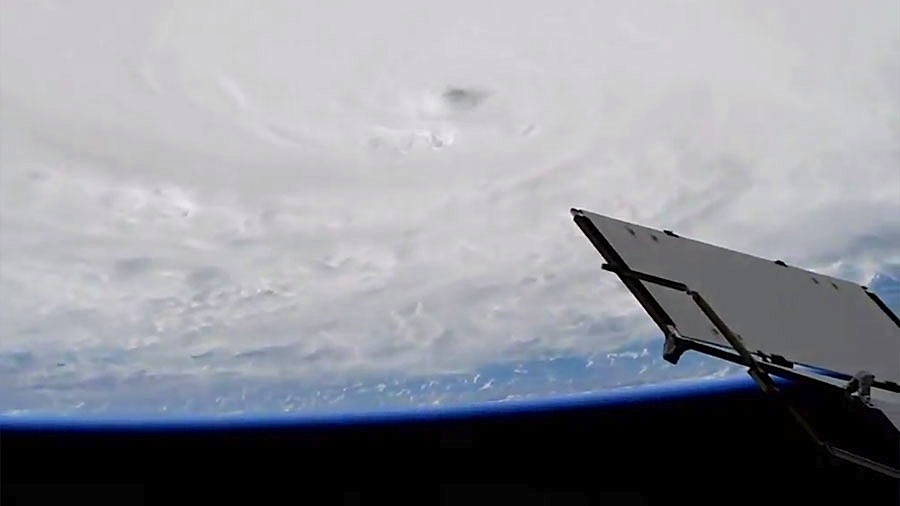
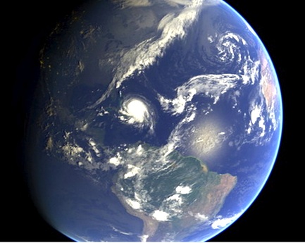
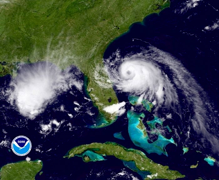
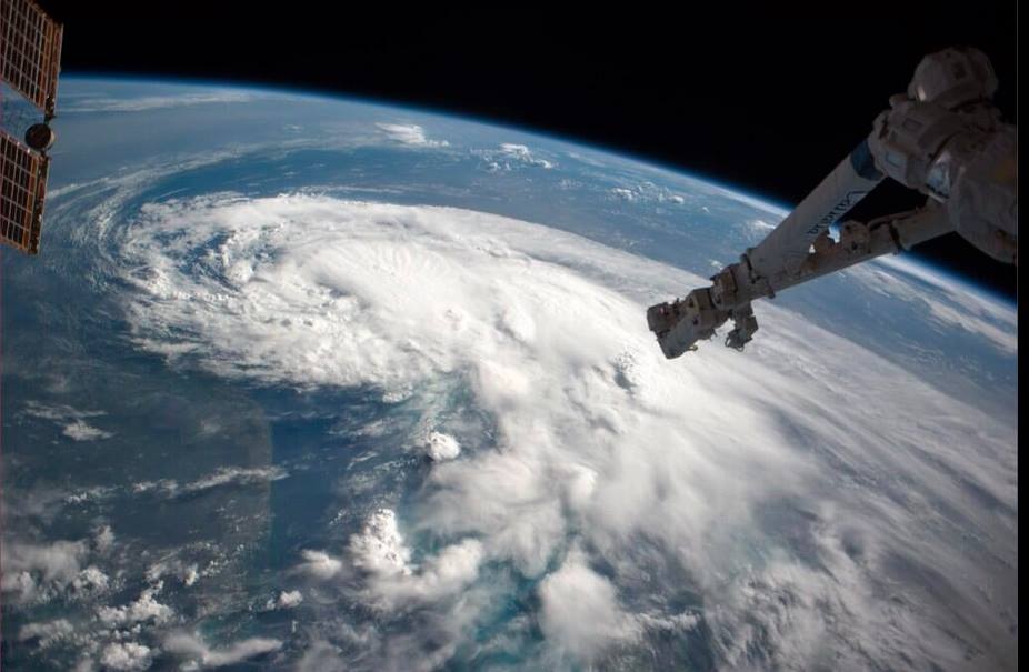
Aerial view of Hurricane Matthew from the International Space Station, October 4hurricane-matthew- aerial view (ISS/ NASA)

The perfect example of the ‘proper’ meaning of awesome can be found in Genesis: ‘He (Jacob) was afraid and said, “How awesome is this place! This is none other than the house of God, and this is the gate of heaven.”‘ Some translations use the word ‘dreadful’ in place of ‘awesome’ for this passage – in its old meaning of ‘full of dread’, not its watered down modern meaning as in ‘dreadful headache’ or ‘dreadful nuisance’ (the same dilution that has happened to ‘terrible’).

Hurricane Matthew Tracking Path (Wunderground)

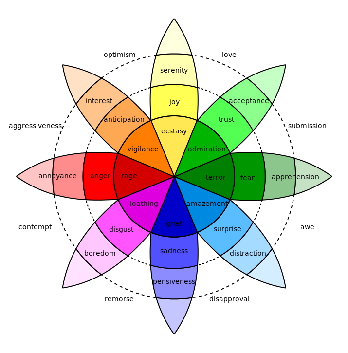
WHAT KIND OF EMOTION IS AWE?

In 1980 a man called Dr Robert Plutchik designed a ‘diagram of emotions’ in a floral wheel format. This device visualised eight basic emotions, with eight derivative emotions each composed of two basic ones. Awe is at 4.00 o’clock, showing the extreme of the Biblical meaning as a mixture of terror and amazement (think of the reaction of the shepherds while watching of their flocks, when unexpectedly interrupted by an angel…). There’s no place in the wheel for ‘awesome’ to mean ‘I really like that photo you took’. Or, ‘your soup is delicious’. Or, ‘I am so pleased to have made a plan to meet you at Pete’s Pub’.
plutchik-wheel-svg

Language is a living thing, and the hyperbolic application of powerful words to mundane emotions or objects is widespread and unsurprising. But a Cat. 4 hurricane really is awesome stricto sensu: it is both an amazing ‘extreme weather event’, and a terrifying one, as the header image and the many images of Matthew’s progress posted online amply  illustrate. The recent practice of  giving hurricanes comfortable names does nothing to dispel their power or the awe they inspire.  On present tracking, Matthew will reach Abaco some time tomorrow. From a safe distance, I wish everyone on Abaco and elsewhere in the target zone all the very best and a safe passage through the storm.

hurricane-matthew-wunderground-clip

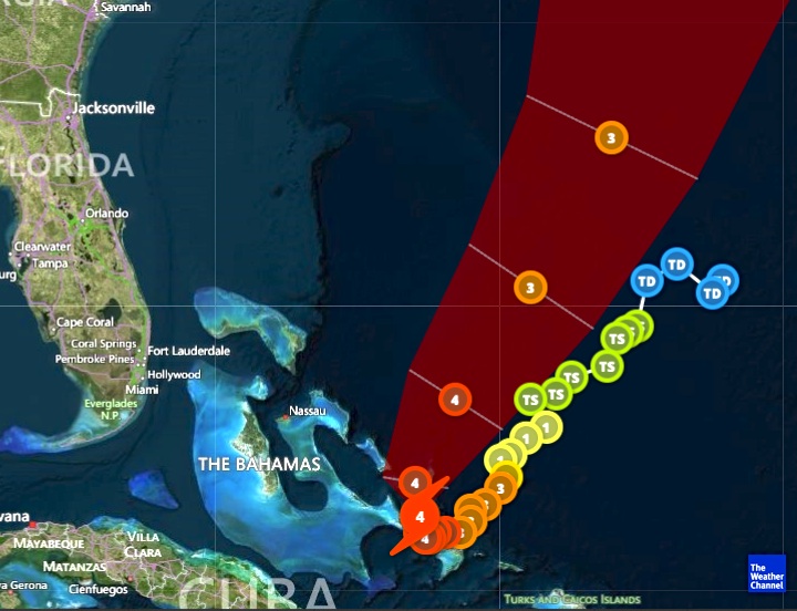
HOW ARE HURRICANES CATEGORISED?

Credit: 'Watts Up With That" - Click image for Hurricane Irene page of this excellent weather & climate site

 FROM ASTOUNDING TO BADASS: AWESOME SYNONYMS ANCIENT & MODERN

Astounding, breathtaking, amazing, stunning, astonishing, awe-inspiring, stupendous, staggering, extraordinary, incredible, unbelievable, magnificent, wonderful, spectacular, remarkable, phenomenal, prodigious, miraculous, sublime, formidable, imposing, impressive, mind-boggling, mind-blowing, out of this world, supercalifragilisticexpialidocious, amazeballs, badass

hurricane-matthew-tracking-clip-craig-setzer-jpg-copy

Credits: Nasa / Goes, NASA / ISS, Wunderground, Craig Setzer

SEEING THE BACK OF HURRICANE JOAQUIN: LATEST UPDATE OCT 3


Hurricane Joaquin at dawn from International Space Station, Oct 2 (Scott Kelly / ISS / NASA)

Hurricane Joaquin at dawn from International Space Station, Oct 2 (Scott Kelly / ISS / NASA)

SEEING THE BACK OF HURRICANE JOAQUIN: LATEST UPDATE OCT 3

Since my post yesterday HERE confirming evidence that Joaquin was hooking out into the Atlantic and away from northern Bahamas, the storm has picked up speed as it now heads for Bermuda. It is also on a direct route to Ireland and the UK, but is already weakening. With the storm now reduced to a Cat. 3, a continuing lessening of intensity is predicted.

In this second – and, I hope, final – post of the hurricane season, the images below show the current state of play early today. I’ll repeat the weather watch links at the end.

Joaquin clears the Bahamas & heads out into the Atlantic towards Bermuda as a Cat. 3 stormHurricane Joaquin Storm path October 3

Forecast eye-path early on Oct 3Hurricane Joaquin Storm path October 3

The remarkable storm path, hooking round over Central Bahamas & going back on itseslfHurricane Joaquin Storm path October 3

The strange beauty of a hurricane captured from spaceHurricane Joaquin over central Bahamas, seen from space

USEFUL DIRECT LINKS FOR HURRICANE INFORMATION

NOAA / NHC

WUNDERGROUND

WEATHER CHANNEL

ACCUWEATHER

NASA

and for local Bahamas news

TRIBUNE 242

Credit: 'Watts Up With That

Sources: NASA, NOAA, ISS / Scott Kelly, Wunderground, Accuweather

HURRICANE JOAQUIN: LATEST TRACKING UPDATE OCTOBER 2


Hurricane Joaquin Oct 2nd 6

HURRICANE JOAQUIN: LATEST TRACKING UPDATE OCTOBER 2

There’s a great deal of information about Hurricane Joaquin flying around the internet right now, which is completely understandable. How quickly things have progressed since Irene in 2011 in the very early days of this blog, when there was little public information and an almost complete absence of information on social media. I posted daily (or more) updates as the hurricane swept up over the Bahamas. In 4 days, and despite communications being largely blanked, I had over 15,000 hits and a mass of questions along the lines ‘Any news of Treasure Cay’; ‘Can you find out how my boat is – Saucy Sue in Little Harbour’; and ‘Hi I’m on Elbow Cay, can you tell my mom in Maine that I’m ok’ [+ email]…

Here is the position today, at 05.00 EDT, according to the various resources that people turn to. Central Bahamas has taken – is taking – a battering and we have the people there very much in mind. But for the northern Bahamas the picture has improved, with the veer of Joaquin’s predicted path to the northeast increasing overnight. This does not mean an absence of strong winds and big waves – these are already being felt. But the most serious area of this Cat 4 hurricane is not expected to pass over Abaco – the direct concern of most readers of this blog. How different from Irene which wrought its havoc right over the island; and Sandy, which took much the same route.

USEFUL DIRECT LINKS FOR HURRICANE JOAQUIN INFORMATION

NOAA / NHC

WUNDERGROUND

WEATHER CHANNEL

ACCUWEATHER

NASA

and for local Bahamas news

TRIBUNE 242

Anyway, all the best to everyone affected by this fierce storm directly or indirectly, and good luck.

Credit: 'Watts Up With That

Hurricane Joaquin Oct 2nd 1Hurricane Joaquin Oct 2nd 3Hurricane Joaquin Oct 2nd 4Hurricane Joaquin Oct 2nd 7Hurricane Joaquin Oct 2nd 5Hurricane Joaquin Oct 2nd 2Sources: NASA, NOAA, Wunderground, Weather Channel, NYT, Accuweather

HURRICANE UPDATE: GONZALO TRACKS AWAY FROM ABACO, BAHAMAS


Hurricane Irene 2011 - the eye right on course for central Abaco

Hurricane Irene 2011 – the eye right on course for central Abaco

HURRICANE UPDATE: GONZALO TRACKS AWAY FROM ABACO, BAHAMAS

STOP PRESS – UPDATE Following yesterday’s post (below), the hurricane’s tendency to track further away from the Bahamas is confirmed by later models, for examples this one from Wunderground. So I think we are officially ‘off-risk’. But Bermuda is definitely not… Anyway, read on a bit and you will find out how hurricanes get their names! 

1901289_599770936795166_5297826701188883150_n

Yesterday I posted on my FB page an NOAA hurricane tracking map update for Hurricane Gonzalo, currently rated Cat. 2 on the SAFFIR-SIMPSON SCALE. It is making its way north through the Caribbean right now, and at one stage the storm cone looked on a possible course for the Bahamas. Abaco has been spared a major cyclone for a couple of years. However memories are very recent of Hurricane Irene (2011) which passed directly over Abaco as a Cat. 3 storm; and Hurricane Sandy (2012) that passed marginally to the east with (at that stage) an intensity of a Cat. 1 before going on to wreak havoc further north. During those ‘extreme weather events’ I posted regularly about them, with tracking maps and photos. At the time of Irene there was remarkable little information around online and I got a huge number of hits – 5000+ in a day, 15,000+ in a week. I also replied to lots of inquiries from the Bahamas, US and Canada, both general (“How are things at Cherokee?”) to very specific (“Do you happen to know if my boat ‘Blowdakidzinheritanz’ moored in Little Harbour is Okay?”).

Hurricane Sandy Earth from Space 2

Hurricane Sandy over Abaco from the International Space Station

I  have been surprised at the response the map generated by way of ‘Likes’ and comments expressing relief… So from my current safe distance of precisely 4250.00 miles from Marsh Harbour, I am posting an update with helpful maps and a bit of general hurricane info. The agencies all agree that Gonzalo will hook east as it progresses northwards. The Bahamas outlook is promising, though for example Bermuda looks to be at risk.  There’s more on hurricanes on the page ABACO WEATHER. I always think that Wunderground produce the clearest maps for general purposes, though there’s a great deal more information to be had from the NOAA site, to which there’s a direct link in the Sidebar (I’ve moved it to near the top for the time being).

CURRENT TRACKING FORECASTS OCT 14 2014 

WUNDERGROUND 3-DAY TRACKING & WIND MAP at201408at201408_satat201408_radar

NOAA TRACKERS & FORECASTS

085519203828W_NL_sm

ACCUWEATHER SATELLITE VIEW & TRACKERHurricane Gonzalo Tracking Map  - clip jpg

THE SAFFIR-SIMPSON SCALE

Here is a reminder of how tropical storms and hurricanes are measured for intensity, as decreed by the S-SS, followed by the National Hurricane Center’s explanation of the gradations of relative intensities.

Saffir-Simpson Scale (Wiki) jpgT

The Saffir-Simpson Hurricane Wind Scale is a 1 to 5 rating based on a hurricane’s sustained wind speed. This scale estimates potential property damage. Hurricanes reaching Category 3 and higher are considered major hurricanes because of their potential for significant loss of life and damage. Category 1 and 2 storms are still dangerous, however, and require preventative measures. In the western North Pacific, the term “super typhoon” is used for tropical cyclones with sustained winds exceeding 150 mph.

Category   Sustained Winds Types of Damage Due to Hurricane Winds
1 74-95 mph
64-82 kt
119-153 km/h
Very dangerous winds will produce some damage: Well-constructed frame homes could have damage to roof, shingles, vinyl siding and gutters. Large branches of trees will snap and shallowly rooted trees may be toppled. Extensive damage to power lines and poles likely will result in power outages that could last a few to several days.
2 96-110 mph
83-95 kt
154-177 km/h
Extremely dangerous winds will cause extensive damage:Well-constructed frame homes could sustain major roof and siding damage. Many shallowly rooted trees will be snapped or uprooted and block numerous roads. Near-total power loss is expected with outages that could last from several days to weeks.
3
(major)
111-129 mph
96-112 kt
178-208 km/h
Devastating damage will occur: Well-built framed homes may incur major damage or removal of roof decking and gable ends. Many trees will be snapped or uprooted, blocking numerous roads. Electricity and water will be unavailable for several days to weeks after the storm passes.
4
(major)
130-156 mph
113-136 kt
209-251 km/h
Catastrophic damage will occur: Well-built framed homes can sustain severe damage with loss of most of the roof structure and/or some exterior walls. Most trees will be snapped or uprooted and power poles downed. Fallen trees and power poles will isolate residential areas. Power outages will last weeks to possibly months. Most of the area will be uninhabitable for weeks or months.
5
(major)
157 mph or higher
137 kt or higher
252 km/h or higher
Catastrophic damage will occur: A high percentage of framed homes will be destroyed, with total roof failure and wall collapse. Fallen trees and power poles will isolate residential areas. Power outages will last for weeks to possibly months. Most of the area will be uninhabitable for weeks or months.

HOW DO HURRICANES GET THEIR NAMES?

Check out the page ABACO WEATHER

BACKTRACKING

Hurricane Irene 2011 Bahamas Map Accu jpg Hurricane Sandy Map Bahamas 2012 jpg

ABACO: COLOURFUL EVEN DURING TROPICAL STORM ARTHUR


-tropical-storm-arthur

Storm Tracker 13

ABACO: COLOURFUL EVEN DURING TROPICAL STORM ARTHUR

As Tropical Storm Arthur blows northwards increasing in strength, Abaco has begun to get its sunshine back. TS Arthur, then defined as a Tropical Depression, hung around over the Northern Bahamas for four days or so before finally clearing. In the past I wrote daily posts about Hurricane Irene and Hurricane Sandy at a time when information was surprisingly hard to come by. Now everyone is on Facebook and it’s easy to post (or find) cyclone reports, maps, path projections and so on. I’m always struck by the contrast between the bleak, dark-clouded snaps that people put up on their FB pages and the cheerfully coloured weather maps that mark the passage of the storm. Here are a few for Tropical Depression Arthur when over Abaco and moving north, taken from the most useful mainstream sites. My favourite is the National Hurricane Center NOAA where the graphic information is presented in a number of formats. However MIKE’S WEATHER PAGE is a good first resort for information – ‘Like’ it and you’ll get the reports you need. For a plethora of graphics on every hurricane aspect, move on to his website http://www.spaghettimodels.com 

Tropical Storm Arthur Weatherbug 2Tropical Storm Arthur Weatherbug 1 Tropical Storm Arthur Weather Underground (props to MOWMuseum Abaco)Props to Man-o-War Museum which posted the image above on FB. The purple pin is Abaco

Tropical Storm Arthur Accuweather GIFThere’s nothing like a GIF to show which way the wind is blowing…

Tropical Storm Arthur NOAA 2Tropical Storm Arthur NOAA 1

IMG_2787IMG_2789 - Version 2

Whenever there’s a bad storm or a hurricane, it’s worth visiting the NASA ISS site for dramatic images from the Space Station. The following link will take you to a dramatic photo of Hurricane Irene in 2011 HERE There’s a search facility on the site. This is a fine image of TS Arthur, illustrating the characteristic swirl pattern of a tropical storm.

Tropical.Storm Arthur NASA_ISS Props Reid Wiseman & Chris ChadwickJPG

Compare the bright graphics above with the reality for those under the massed clouds in strong wind and scything rain… Cheers for these vividly gloomy images to Julias Sawyer, Cindy James Pinder and Albury’s Ferries (who post almost daily images of Abaco weather as the ‘Donnies’ ply the seas between the main island and the outlying Cays with their passengers and cargo…)

TD Arthur, over Abaco Julias Sawyer Tropical Storm BPS Cindy James Pinder TS Arthur Albury's Ferry Service

I can’t resist adding an ‘Abaco summer weather’ photograph taken by Amanda Diedrick on Green Turtle Cay. There was a passing bout of bad weather was a couple of weeks back, and Amanda managed to take this extraordinary photo of a bolt of forked lightning apparently burning straight through a small cloud. It’s difficult to get a good lightning shot without special cameras, compartic lenses, Fitzallan filters, aperture reticulators and the like. She did it!*

Lightning Bolt GTC Amanada Diedrick

The start of the summer season is a good time to roll out the Saffir-Simpson Scale, from which you will see how the various intensities of storm are graded. It’s colourful as well.

Saffir-Simpson Hurricane Scale

Credit: ‘Watts Up With That” – an excellent weather & climate site

 *All camera terminology is invented to make it seem as if i know what I am talking about. Beyond ‘Point and  Shoot’, I’m lost…