ABACO’S OWN ‘AERO-DRONE’: GREAT AERIAL SHOTS BY ‘MR REES’
David Rees is well known for his excellent photography, not least because of his early adoption of a drone – a serious bit of kit, not a toy ‘copter + camera – for capturing some wonderful aerial views of Abaco. Photos from the air can give so much more information about the setting of a particular location, and a drone can achieve a proximity and reveal details that an aeroplane shot cannot. I have seen some of David’s photographs in an exhibition at BPS, where they had been enlarged to make stunningly effective prints. David was kind enough to agree to my request to showcase a few of his photos, so I’ll let them do the talking…
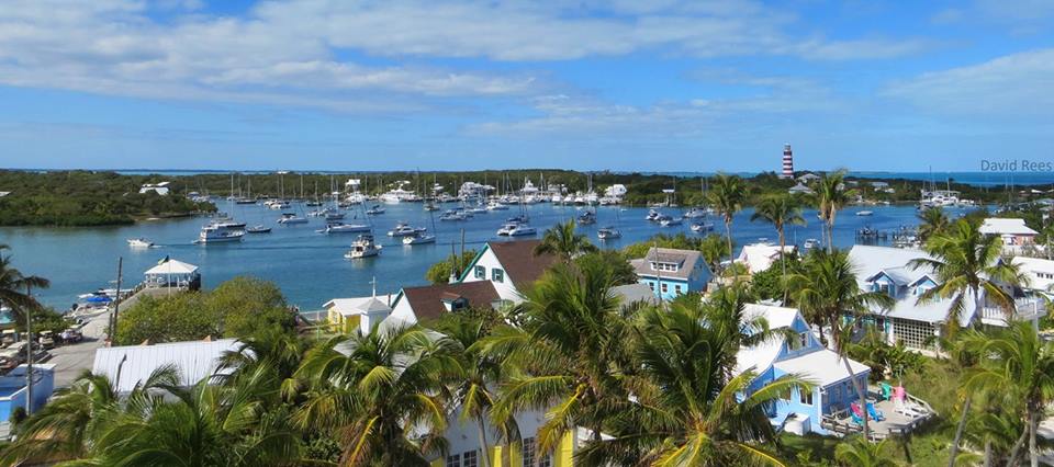
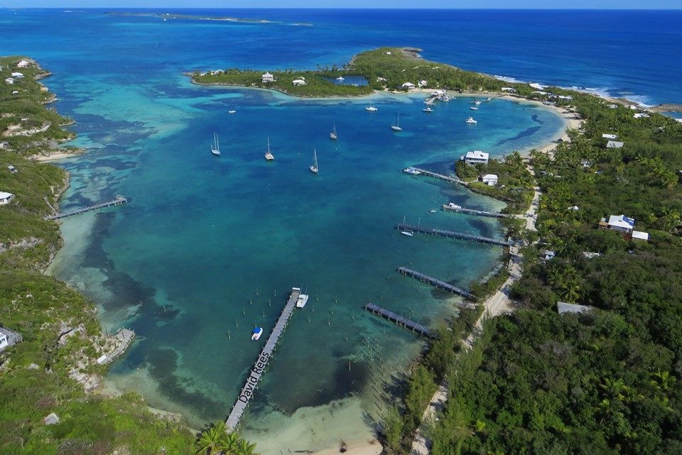
HOPE TOWN / ELBOW CAY
TAHITI BEACH
CHEROKEE
The Long Dock, Cherokee – the longest wooden dock in the entire Bahamas
CASUARINA
TREASURE CAY
Voted one of the 10 loveliest beaches in the Caribbean by the National Geographic, no less
MARSH HARBOUR
SCOTLAND CAY
GREEN TURTLE CAY
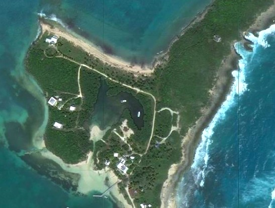
LITTLE HARBOUR
All photos by David Rees, assisted by his amazing drone, with many thanks for use permission
“Several years back, on a family road trip to the south end of the Abaco mainland, we took a quick swing through the settlement of Cherokee Sound. Though our stop was brief, I was enchanted by the beauty of the tiny town and its breathtaking beach.
Earlier this year, I finally got the chance to get back to Cherokee. I spent an afternoon wandering through this small fishing village that, by comparison, makes sedate Green Turtle Cay seem like a lively metropolis.
Similar to Green Turtle, Cherokee was originally settled by Loyalist descendants who supported their families by fishing or building boats. Today, fewer than 200 residents — most of whom commute to other parts of Abaco for work — call Cherokee Sound home.
Though Cherokee’s streets were virtually deserted on the hot June afternoon I visited, I did spot a group of primary school students enjoying recess, and I met a few locals while photographing their quaint, colourful homes.
And then there’s that beach. That stunning, unspoiled beach. And jutting 700 feet out into the clear water, a beautiful old dock which, according to the sign posted nearby, is the longest wooden pier in the Bahamas.
Until a few decades ago, the only way into Cherokee Sound was by sea. And given the shallow waters surrounding the settlement, an extended pier was a necessity. These days, with a paved road connecting Cherokee to the rest of the Abaco mainland, the dock functions primarily as a tourist attraction.
The Old Jetty at Casuarina, Abaco – the pre-road shortcut to Cherokee (RH)
To get to Cherokee Sound from Marsh Harbour, head south on the main highway and turn left when you reach the sign below:
Follow the winding road until it ends at Cherokee Sound. The drive from Marsh Harbour takes 30-45 minutes or so.
Between the highway and Cherokee, there are two key points of interest and they could not be more different.Pete’s Pub and Galleryis a rustic, off-the-grid, on-the-sand restaurant that serves up local seafood and stunning ocean views, while theAbaco Club at Winding Bay is a manicured beachfront resort with a spa and fitness center, full-size golf course and pro shop.
If it’s meal time or you’re in need of refreshments, I’d suggest stopping at Pete’s or the Abaco Club, as there are no restaurants in Cherokee Sound. Nor are there any hotels, though a quick online search reveals nearly a dozen vacation homes for rent in or near the village.
Below are a few of the photos I shot that afternoon. And if you’d like to know more about Cherokee Sound and its history, here’s a greatarticle by Abaco Life editor, Jim Kerr.“
CREDITS Post and images courtesy of Amanda Diedrick of Green Turtle Cay and her wonderful blog LITTLE HOUSE BY THE FERRYEspecially interesting are the accounts of the careful restoration of her family home with her husband Tom – a labour of love. There are other articles about GTC history, and plenty of lovely photos to enjoy. Jetty photo and map RH
ABACO’S FORGOTTEN LIGHTHOUSE: THE “OLD LIGHTHOUSE”, LITTLE HARBOUR
Little Harbour Abaco, Aerial View (Simon Rodehn)
There’s relatively little that a casual investigator can discover about the ruined lighthouse at Little Harbour, Abaco. This hurricane-damaged wreck is Abaco’s third and largely unknown light, after the icon onELBOW REEFand the desolate but romanticHOLE-IN-THE-WALLthat stands on the southern tip of Abaco, down 15 miles of dodgy track through the National Park. Two specific sources of information begin our tour of the “Old Lighthouse at Little Harbour.
“LITTLE HARBOUR Date unknown (station established 1889). Inactive. Ruins of a 1-story concrete keeper’s quarters, known locally as the “old lighthouse.” A modern steel framework tower carried an active light until it was blown over by Hurricane Sandy in October 2012; Trabas has Darlene Chisholm’s photo of the toppled light. A photo and a very distant view are available, and Bing has a satellite view. In an aerial view of the harbor, the light is on the peninsula at upper right. Located at the entrance to Little Harbour, about 25 km (15 mi) south of Marsh Harbour, Great Abaco Island. Accessible by a short walk to the end of the peninsula sheltering the harbor. Site open, tower closed. Site manager: unknown. ARLHS BAH-021; Admiralty J4576; NGA 11808.”
Often overlooked is (or should we say was) the “Old Lighthouse” as it is called. It was established in 1889 at the entrance to of Little Harbour channel, the southern entrance to Abaco Sound. Once it was a manned light, with the lighthouse keeper and his wife being the only inhabitants of Little Harbour. Of course the keepers are long gone and so is most of the house. The light tower was converted to solar in modern times but was dealt a devastating blow by Hurricane Floyd in 1999. Access is via a path which starts from the shoreline and winds up the hill through seagrapes and bush. Few people venture up here these days. If there is a big ocean swell running, walk down to the cliff top in front of the lighthouse, where you’ll find a blowhole known as the Dragon. Depending on swell height, it could be roaring, snorting and shooting out clouds of spray. Sandy Estabrook
Photos referenced by Rowlett – see extract above
Note the steel frame tower on the right, a structure replacing the old light destroyed by Hurricane Floyd in 1999; and itself toppled by Hurricane Sandy in 2012
A GALLERY OF RECENT IMAGES
Lighthouse ruins, Little Harbour Abaco, Patrick Shyu. The only interior shot I could find. Note the fallen steel tower (2012) (and seen from the outside below)
Lighthouse ruins, Little Harbour Abaco – Patrick Shyu
Little Harbour lighthouse Abaco, post Hurricane Sandy – Darlene Chisholm
The Old Lighthouse ruins, taken during a cruise (MV Shingebiss)
LOCATION
In the header image, the location of the Light, looking very roughly north, is shown as a grey pimple on the eastern peninsula that forms the Little Harbour bay. There is no other building in this area. Below are some additional aerial maps showing the path to the Light and its relative remoteness. It is not covered in the wonderful book on Bahamas lighthouses by Annie Potts entitled “Last Lights”(2011, Fish House Press). I surmise that this small Light was more of a beacon to pinpoint the location of the entrance to Little Harbour, and perhaps to enable triangulation with the large lights atELBOW REEFandHOLE-IN-THE-WALL.
An unusual aerial view of Little Harbour Lighthouse from the north, showing the path to it. You can see the ‘modern steel framework tower’ referred to in the ROWLETT entry above, replacing the original lighthouse tower destroyed by Hurricane Floyd and later toppled by Hurricane Sandy.
Little Harbour lighthouse Marinas.com
Credits: Simon Rodehn (LH aerial view – thanks again!), Rowlett’s Lighthouses, Sandy Estabrook / Abaco Escape, Wiki Map, Patrick Shyu, Darlene Chisholm, MV Shingbiss, marinas.com
A TRIP TO CHEROKEE & LITTLE HARBOUR(revised Oct 2012)
YOU WILL NEED camera; binoculars; possibly swimming kit; a car with (if you are going to get seriously stuck in at Pete’s Pub) a non-drinking driver; good appetite; and if you get weather like we did, something waterproof to wear…
ROUTE Turn right at the end of the drive, head north past Bahama Palm Shores until you get to the right-hand turn to Cherokee / Little Harbour / Winding Bay. Take the made-up road to the end, following the right-hand bend that will bring you to Cherokee. You will pass the Abaco Club, Winding Bay, a Ritz-Carlton enterprise. It doesn’t need any meagre publicity from this quarter – just ask Sandy what you have to do to play golf there, eat there, use the spa, buy a cabana and so forth.
ABACO CLUB, WINDING BAY
Photo Credit: Simon Rodehn
Continue to CHEROKEE, park and have a wander round this charming settlement. It poured when we went and we were barely able to leave the car… so any description I could give is obscured by extreme wet, low cloud and yes, a touch of gloom. Not even any birds to report. Explore for yourself, why not. Thanks to Simon Rodehn for his fine aerial views of the Abaco Club Cherokee (and see his aerial view of LITTLE HARBOUR at the end of this post).
CHEROKEEPhoto Credit: Simon Rodehn
After you have had a look round Cherokee, drive back the way you came, past the Abaco Club, until you get to a right-hand junction with a sign to Pete’s Pub and Little Harbour. This is described on the map as ‘dirt road’, which doesn’t do justice to some of the impressive rocks en route. However, with care it is easily negotiable by car. Carry on until you get to Pete’s, which is a good place to leave the car and explore from.
LITTLE HARBOUR is a good place to wander round. Nice boats for a start; the renowned Johnston’s Foundry, with examples of its work scattered round; the Gallery, which is well worth investigating; a shell-strewn beach on the back-side (as it were). And Pete’s Pub for excellent sustenance at the end of it all… fresh fish of many kinds, and a lot more besides. Here are some pictures – I haven’t attempted to photoshop them to disguise the fact that the weather that day was… inclement. Bleak, even. On a sunny day, when you go, it will surely look better…
MAIN STREET, LITTLE HARBOUR
PETE’S PUB
PETE’S PUB – BRING YOU OWN TEE
THE GALLERY, LITTLE HARBOUR
THE BEACHShells, but no idea about the swimming: thwarted by drizzle!
PETE’S PUB & GALLERY Here is the direct link to Pete’s, where you will find all the info you could wish for about the Pub, the Foundry, the Johnston family, cottage rental, fishing and the locality generally. There are also plenty of excellent pictures, so check it out for a far sunnier view than I have provided here.


 Until a few decades ago, the only way into Cherokee Sound was by sea. And given the shallow waters surrounding the settlement, an extended pier was a necessity. These days, with a paved road connecting Cherokee to the rest of the Abaco mainland, the dock functions primarily as a tourist attraction.


You must be logged in to post a comment.