STARK’S “HISTORY OF & GUIDE TO THE BAHAMAS”


047-copy

STARK’S “HISTORY OF & GUIDE TO THE BAHAMAS”

James H. Stark appears to have been, for his time, a veritable Rough Guide for the Caribbean. In 1891 he produced an entrancing tome, the commendably grammatically correctly-titled “Stark’s History of and Guide to the Bahama Islands Containing a Description of Everything on or About the Bahama Islands of Which the Visitor or Resident May Desire Information, Including Their History, Inhabitants, Climate, Agriculture, Geology, Government and Resources”. More of his other magna opera below.

Stark's History of & Guide to the Bahamas     Stark's History of & Guide to the Bahamas

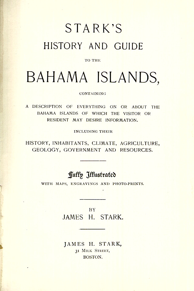
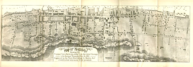
 The jaunty and classic late c19 cover depicts the landing of Columbus, lest the unwary reader should be so ill-informed as the be unaware of the location of the great explorer’s landfall. And gives the date of the event, for the sake of completeness. The title page is most informative of the contents, and manages to namecheck the author three times (or thrice, as he might have put it). The illustrations and in particular the maps are wonderful, and call for a small gallery for your enjoyment. The “Coast Chart” is compiled from “the latest… surveys.” The map of Nassau is most interesting to compare with a map of 125 years later. And the engraved map is set at an unusual angle to say the least. [I’ve tried to clip the Abaco part to check the place names, but I can’t yet get a clear enough image to read].

Stark's History of & Guide to the Bahamas - Bahamas Map

Stark's History of & Guide to the Bahamas - Nassau map

Stark's History of & Guide to the Bahamas - Bahama Islands Map

An historic map from 100 years earlier: note the place names, eg ‘Alabaster’ (Eleuthera)129

The ‘History of & Guide to’ has detailed sections on all the islands. I have lifted the relevant pages – only a few – concerning Abaco. See what a difference 125 years makes…

145146147

I enjoyed reading the ‘opinions of the press’. How unlike our own dear Amazon reviews…Stark's History of & Guide to the Bahamas    Stark's History of & Guide to the Bahamas

005

RAISING A CONTROVERSY…

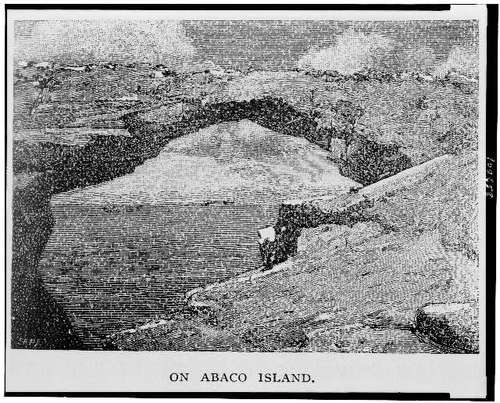
This is a topic I have touched on before. It concerns the authentic location of the ‘Glass Window’ of Winslow Homer’s famous painting. Is it Eleuthera (as claimed) or Abaco (as contended). The argument is lodged with the Brooklyn Museum, custodian of the Homer painting. In Stark’s book of 1891 is a fine photograph of a – or the? – ‘glass window’, assigned to Eleuthera. Below is an earlier engraving entitled ‘On Abaco Island’. It is the work of Homer, named by him, and seemingly a preliminary study for the painting. The same view? Or different? The jury is still listening to the arguments… 

136aHole-in-the-Wall Picture

Winslow Homer G W Original Brooklyn

Other books by James H. Stark that you may enjoy:

Stark’s History and Guide to Barbados and the Caribee Islands, Containing a Description of Everything on or About These Islands of Which the Visitor or Resident May Desire Information – Including Their History, Inhabitants, Climate, Agriculture, Geology (1893)

A ditto for Trinidad.

A ditto for ‘Boston and its Suburbs’

A ditto to the County of Ohio

md14322205683

HOLE-IN-THE-WALL for more about Hole-in-the-Wall, Abaco and Winslow Homer

Credits: my primary source is the University of Florida Digital Collection, to which thanks. However there are plenty of mainstream online sites that offer this book to view; and you can download it or even get your own POD (‘print on demand’). 

ABACO HISTORY: GREEN TURTLE CAY & THOSE WHO STAYED


Black Sound, GTC, Abaco (Amanda Diedrick)

‘THOSE WHO STAYED’

I am very pleased to feature Amanda Diedrick’s wonderful new book about the the history of Abaco generally and Green Turtle Cay specifically. Publication is imminent. Without more ado I will leave you with Amanda’s own description of her book, which is illustrated with paintings by illustrious Abaco & GTC artist Alton Lowe. It also contains unique historic photographs that record Abaco’s rich heritage. The book details are shown below, and there’s even a handy Paypal link if – as I hope – you cannot be restrained from the temptation to buy a copy. Or maybe two. And you can follow Amanda’s fascinating and rewarding blog at LITTLE HOUSE BY THE FERRY

greenturtlesignnew

“Visitors often describe New Plymouth on Green Turtle Cay as a charming fishing village, its narrow streets, clapboard homes and colourful flowers reminiscent of a New England town.

cover-with-shadow-2

But beneath this sweet façade is a past of piracy, poverty and privilege.

Hints of New Plymouth’s history are all around. A rusted anchor at Settlement Point. Two cannon standing guard on the public dock. Broken tombstones on the beach.  An old jail with stairs that lead nowhere.

For more than a thousand years, settlers have come here, drawn by the safety of the land and the bounty of the sea. And as the waves contour the shore, so have these migrants shaped this tiny cay.

By fate and occasionally by force, most were carried away.  A resilient few remained.

This is their story.”

ABOUT THOSE WHO STAYED

  • Print length: 185 pages
  • Book size: 8.5” x 11”
  • Full colour
  • Hard cover
  • Publication date: November 20, 2016
  • Images: 200+, including many never-before published historic photographs, and original oil paintings by world-renowned artist and Green Turtle Cay native, Alton Lowe
  • Price: $79.00

Buy Now Button

Books will ship at the end of November. All orders received by November 25 will be delivered before Christmas.

ABOUT THE AUTHORamanda-profile-pic-for-web

A writer for more than 25 years, Amanda Diedrick is a ninth-generation Bahamian who counts Loyalist settlers Wyannie Malone and Nathan Key and pirate Matthew Lowe among her ancestors.

In 2012, she and her husband Tom Walters purchased the tiny cottage on Green Turtle Cay that her great-grandparents, Herman and May Curry, built after the 1932 hurricane destroyed their grand home.

Amanda documents the ongoing restoration of her ancestral home and writes about Green Turtle Cay and its history on her blog, Little House by the Ferry [link above. RH]

Tom, Amanda and their dog, Wrigley, divide their time between Green Turtle Cay and Los Angeles.

ABOUT THE ARTIST

As with so many Bahamians, it wasn’t until Alton Lowe left home at 16 to become an artist that he truly realized the uniqueness and beauty of his home country.

alton-lowe

In the decades since, he has devoted himself to capturing the people, scenes and history of the Bahamas in original oil paintings.

Lowe’s colourful works hang in public and private collections worldwide, including those of HRH Queen Elizabeth and Prince Philip, as well as Prince Charles and the late Princess Diana. He has staged 38 one-man shows to date, and more than 100 of his works have been commissioned by the Bahamian government for use as postage stamps.

Reflecting his commitment to preserving Bahamian history, Lowe founded Green Turtle Cay’s Albert Lowe Museum and was instrumental in the creation of the island’s Loyalist Memorial Sculpture Garden and Island Roots Heritage Festival.

Through his body of work, he hopes to convey the magnificence of the Bahamas and to inspire his fellow Bahamians to appreciate, enhance and protect their remarkable history for future generations.

cover-with-shadow-2

Text and images Amanda Diedrick except welcome sign (GTC Rentals) and the photo below (socmed / open source)

Abaco map by Thompson (1812): note the strange geography, place names and spellings

For more historic Abaco maps click HEREabaco-historic-map-thompson-1815-crop-copy

The opening of the Albert Lowe Museum, Green Turtle Cay, AbacoAlbert Lowe Museum GTC Opening Nov 1976

ABACO’S FORGOTTEN LIGHTHOUSE: THE “OLD LIGHTHOUSE”, LITTLE HARBOUR


ABACO’S FORGOTTEN LIGHTHOUSE: THE “OLD LIGHTHOUSE”, LITTLE HARBOUR

Little Harbour Abaco, Aerial View -Simon Rodehn annotated

Little Harbour Abaco, Aerial View (Simon Rodehn)

There’s relatively little that a casual investigator can discover about the ruined lighthouse at Little Harbour, Abaco. This hurricane-damaged wreck is Abaco’s third and largely unknown light, after the icon on ELBOW REEF and the desolate but romantic HOLE-IN-THE-WALL that stands on the southern tip of Abaco, down 15 miles of dodgy track through the National Park. Two specific sources of information begin our tour of the “Old Lighthouse at Little Harbour.

Extract from ROWLETT LIGHTHOUSES OF THE BAHAMAS

“LITTLE HARBOUR Date unknown (station established 1889). Inactive. Ruins of a 1-story concrete keeper’s quarters, known locally as the “old lighthouse.” A modern steel framework tower carried an active light until it was blown over by Hurricane Sandy in October 2012; Trabas has Darlene Chisholm’s photo of the toppled light. A photo and a very distant view are available, and Bing has a satellite view. In an aerial view of the harbor, the light is on the peninsula at upper right. Located at the entrance to Little Harbour, about 25 km (15 mi) south of Marsh Harbour, Great Abaco Island. Accessible by a short walk to the end of the peninsula sheltering the harbor. Site open, tower closed. Site manager: unknown. ARLHS BAH-021; Admiralty J4576; NGA 11808.”

The “Old Lighthouse” – Little Harbour, Abaco

Abaco Escape  – Sandy Estabrook’s essential GUIDE TO THE ABACOS

Often overlooked is (or should we say was) the “Old Lighthouse” as it is called. It was established in 1889 at the entrance to of Little Harbour channel, the southern entrance to Abaco Sound. Once it was a manned light, with the lighthouse keeper and his wife being the only inhabitants of Little Harbour. Of course the keepers are long gone and so is most of the house. The light tower was converted to solar in modern times but was dealt a devastating blow by Hurricane Floyd in 1999. Access is via a path which starts from the shoreline and winds up the hill through seagrapes and bush. Few people venture up here these days. If there is a big ocean swell running, walk down to the cliff top in front of the lighthouse, where you’ll find a blowhole known as the Dragon. Depending on swell height, it could be roaring, snorting and shooting out clouds of spray. Sandy Estabrook

Photos referenced by Rowlett  – see extract above

Note the steel frame tower on the right, a structure replacing the old light destroyed by Hurricane Floyd in 1999; and itself toppled by Hurricane Sandy in 2012

A GALLERY OF RECENT IMAGES

Lighthouse ruins, Little Harbour Abaco, Patrick Shyu

Lighthouse ruins, Little Harbour Abaco, Patrick Shyu. The only interior shot I could find. Note the fallen steel tower (2012) (and seen from the outside below)

Lighthouse ruins, Little Harbour Abaco - Patrick Shyu

Lighthouse ruins, Little Harbour Abaco – Patrick Shyu

Little Harbour lighthouse Abaco - Darlene Chisholm

Little Harbour lighthouse Abaco, post Hurricane Sandy – Darlene Chisholm

Little Harbour Lighthouse Ruins, Abacos - MV Shingebiss

The Old Lighthouse ruins, taken during a cruise (MV Shingebiss)

LOCATION

In the header image, the location of the Light, looking very roughly north, is shown as a grey pimple on the eastern peninsula that forms the Little Harbour bay. There is no other building in this area. Below are some additional aerial maps showing the path to the Light and its relative remoteness. It is not covered in the wonderful book on Bahamas lighthouses by Annie Potts entitled “Last Lights” (2011, Fish House Press). I surmise that this small Light was more of a beacon to pinpoint the location of the entrance to Little Harbour, and perhaps to enable triangulation with the large lights at ELBOW REEF and HOLE-IN-THE-WALL.

Little Harbour Lighthouse 1 jpg copy

Little Harbour Lighthouse 2 jpg

An unusual aerial view of Little Harbour Lighthouse from the north, showing the path to it. You can see the ‘modern steel framework tower’ referred to in the ROWLETT entry above, replacing the original lighthouse tower destroyed by Hurricane Floyd and later toppled by Hurricane Sandy.

Little Harbour Lighthouse Marinas.com

Little Harbour lighthouse Marinas.com

Credits:  Simon Rodehn (LH aerial view – thanks again!), Rowlett’s Lighthouses, Sandy Estabrook / Abaco Escape, Wiki Map, Patrick Shyu, Darlene Chisholm, MV Shingbiss, marinas.com

ELBOW REEF LIGHTHOUSE, HOPE TOWN, ABACO: 150 YEARS OLD TODAY!


HT Lighthouse 1

HOPE TOWN LIGHTHOUSE ABACO: THE WORKS

ELBOW REEF LIGHTHOUSE, as it is properly called, is 150 years old. It is the stripy icon of Abaco – and quite flashy as well. One of the last remaining kerosene-lit lighthouses in the world, it retains its mechanisms and fresnel lenses in remarkable condition, a tribute to the conservation lovingly devoted to the building. Below is a re-post of an article I wrote some time ago, with photos of some of the internal works and some facts and figures thrown in, There’s a big event in the lighthouse’s honour today – here’s the flyer for it. We’ve donated a signed copy of “The Birds of Abaco” for auction, and I hope it makes a few $$$$ for the cause.

photo copy

Bahamas Lighthouse Pres Soc Logo     Bahamas Lighthouse Pres Soc Logo    Bahamas Lighthouse Pres Soc Logo    Bahamas Lighthouse Pres Soc Logo    Bahamas Lighthouse Pres Soc Logo

Hope Town Lighthouse, Abaco

Our visit to Elbow Cay was one part of our day’s Island Hopping / Reef Snorkelling expedition with Kay Politano. In Hope Town, while most of the party wandered round the streets (and shops…) Mrs RH took the boat across the harbour to the Hope Town Lighthouse. This must be the best known landmark of Abaco – ‘iconic’, perhaps, in the modern sense of the word. The weather on the day was pretty poor, with thick cloud and intermittent rain and drizzle. Which is a pity, because the photos would have looked even better with sunshine and blue sky… 

                                          All photos: Mrs Rolling Harbour


HOPE TOWN LIGHTHOUSE FACTS

(CLICK  on Coordinates below for position and Hope Town info)

Location: Elbow Cay, port of Hope Town
Coordinates 26.539421°N 76.958840°W
Year first constructed: 1862
Year first lit: 1864
Construction: Masonry
Tower shape: Conical
Markings/Pattern: Red and white bands
Focal Height: 37 m (121 ft)
Original lens: First order Fresnel
Range: 23 nmi
Characteristic: Fl(5) 15s
Admiralty number: J4572
NGA number: 11800
ARLHS number: BAH-010

THE HOPE TOWN LIGHTHOUSE is one of only three Manual Lighthouses left in the World. It has a spring mechanism that has to be hand cranked every few hours to maintain the sequence of five white flashes every 15 seconds. The lamp burns kerosene with a wick and mantle. The light is then focused as it passes through the optics of a first order (largest size) Fresnel lens which floats on a bed of mercury.

A FRESNEL LENS (pron. ‘Fray-nel’) is a type of lens originally developed by a French physicist Augustin-Jean Fresnel specifically for lighthouses.Compared to conventional bulky lenses, the Fresnel lens is much thinner, larger, and flatter, and captures more oblique light from a light source, thus allowing lighthouses to be visible over much greater distances. Fresnel’s lighthouse lenses ordinarily fell into six orders based on their focal length, first order being the largest (wiki-assist)

For some more images of this iconic – or do I mean symbolic (discuss) – building CLICK===>>> ILOVEHOPETOWN You’ll find that around half the images are of the lighthouse, internal and external. Then look at the colourful remainder. Then it’s a short step to the Facebook page and more info about this charming Cay

Logo of the World Lighthouse Society

MARSH HARBOUR ONLINE MUSEUM: A NEW RESOURCE FOR OLD ABACO


Marsh Harbour, Abaco - Old Photo

MARSH HARBOUR ONLINE MUSEUM: A NEW RESOURCE FOR OLD ABACO

There’s a new arrival on Facebook, and the word is already out. Within 12 hours the page has gained 119 followers*. Already there are some wonderful old photos of family groups and MH residents. Some are named; some may be waiting for someone to recognise them. The header image (thanks for use permission, MHOM) is both instantly recognisable yet puzzling. Is that Snappas over there… no, look, there…? To get straight to the page, click HERE. I guess they’ll want to hear from anyone who has old photos or postcards of MH; or who can help with ID of people and places.

cropped-option-7-copy

There is a similar resource for GREEN TURTLE CAY, where Amanda has a great blog LITTLE HOUSE BY THE FERRY. In part it records the restoration of her family home. However, it is also packed with old photos (with people invited to name the unknowns) and details of a fascinating genealogy project through DNA samples. MAN-O-WAR CAY has a Facebook Group called Man-o-War Cay and Abaco Family History with similar aims. HOPE TOWN has a very active Facebook page fronted by the iconic LIGHTHOUSE. And so on. Not forgetting the museums such as the WYANNIE MALONE MUSEUM, Hope Town and the MAN-O-WAR CAY HERITAGE MUSEUM.

‘Elbow Reef’ – antique engraving Hope Town Abaco - historic print

I am neither Abaconian nor even a second-homer, so I tread lightly in these matters for obvious reasons. However, I have posted a few items about Abaco’s history from time to time so I’ll add a few links below in case anyone is tempted to investigate further. Meanwhile, I notice that in the time I have put this post together, the followers for MHOM have risen to 139…

ABACO HISTORY: SHIPS, MAPS & HOLE-IN-THE-WALL

CHARLES CORY’S C19 BIRDING EXPEDITIONS TO ABACO

“GLIMPSES OF LIFE ALONG A CORAL REEF” A c19 NATURALIST VISITS ABACO

MAN-O-WAR CAY, ABACO: THE HIDDEN BOAT-BUILDING VILLAGE

HOPE TOWN LIGHTHOUSE, ELBOW CAY, ABACO – A BEACON ICON

I’ll end with what I believe to be the oldest known depiction of Hole-in-the-Wall in all its glory, before Hurricane Sandy did for it. It’s an aquatint published in the Naval Review in 1803. If you want to know what the ships are, you’ll have to click the top link. This will also offer you a number of other posts about Hole-in-the-Wall and Abaco more generally, traced through historic maps. Or just open a Kalik, why not. hole-in-the-wall-print-1803

*In the same time, poor Miley Cyrus has lost 2314. Wrecking Ball indeed. Whoops! There go another 249…

HOLE-IN-THE-WALL ABACO: HISTORIC 1803 DESCRIPTION & AQUATINT


HOLE-IN-THE-WALL, ABACO: A HISTORIC DESCRIPTION & AQUATINT FROM 1803

I recently traced the history of Hole-in-the-Wall, Abaco through maps from the 16th century onwards – its significance, the name changes, and so on. To see that post CLICK HERE . I have just come across some historical material about HITW that is so fascinating that I have awarded the accolade of a separate post, rather than lumping it in with the earlier one. The extract below is from THE NAVAL CHRONICLE (Vol 9) * for January – July 1803. It gives a short but detailed description of the Hole in the Wall in the context of a remarkable sketch (reproduced as a Plate in the book) submitted by the contributor, who signed himself  ‘Half-Pay’. That was the name traditionally used in both Navy and Army to refer to the pay or allowance an officer received when in retirement or not in actual service – or, metonomously, to the officer receiving the reduced pay. I greatly like the charming deference with which the contribution is offered.

The whole book is well worth examining for the light it sheds on Naval matters at the very start of the c19. The comprehensive personnel and other lists hold plenty of interest. This was an era of almost continuous major military and naval campaigns on both sides of the Atlantic. The Battle of Trafalgar was still 2 years away when this book was published. If you want to see the downloadable online version CLICK HERE  [I had to zoom the page and clip it in two to make it easily readable  – hence the gap. And apologies for the purple highlight – it was my place-mark…]


Here is the amazing aquatint  by J. Wells of Half-Pay’s sketch, published in the 1803 Naval Chronicle by founder J.Gold of Shoe Lane, London. It’s quite small, measuring 5½” x 9″. You may even be looking at a screen clip of a scan of the book plate of the earliest surviving depiction of Hole-in-the Wall. If anyone knows of an older one, please get in touch. And can anyone identify what kind of sailing vessels these are (I wouldn’t know a brigantine from a clipper…)?

To answer queries arising from my earlier post, I added a map and photos showing exactly where the actual Hole at HITW is, and how to get there (if you are wearing the right shoes). It’s worth revisiting the topic. People are always fascinated by the extremities of land – ‘Land’s End’, ‘Finisterre’, ‘Finistère’ and so on – especially where they are remote and relatively inaccessible. I think HITW qualifies. As far as I am aware, apart from the lighthouse its abandoned outbuildings at the southeast corner of the first map below, there is no other building in the area covered by this map. The nearest road is 15 miles up the inhospitable track to the north of the lighthouse.

Here is the map showing the location of the actual Hole in the Wall, and below that, a distance shot taken at sea

 * According to The Philadelphia Print Shop “Between 1799 and 1818, The Naval Chronicle, was the pre-eminent maritime journal reporting news about the British navy. Issued twice a year, it was published during a period in which the British navy fought the Napoleonic Wars and the War of 1812, and came to “rule the waves.” This wonderful journal included action reports, intelligence on various matters related to the British and other navies, and biographies of naval officers. Many of the reports were accounts by officers directly involved, such as Lord Horatio Nelson. Included with the articles were portraits, images of naval action, and views of the many ports in which the navy called. These are important, first-hand images of this turbulent period”