HURRICANE IRMA AFTERMATH: ABACO’S SIDESWIPE(S)
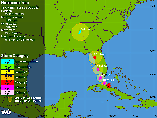
Hurricane Irma barrels on northwards as Florida begins to count the cost. Abaco has had its turn to experience the awesome power of this brute of a storm. Or make that turns (plural) because such a massive storm 400 miles across, spiralling longs strands of filthy weather outwards with centrifugal menace, can strike more than once as the main storm passes further off.
Thanks to the relatively late shift of the storm’s path to the west, there was no direct hit on Abaco (as was once forecast). High winds and heavy seas, but none of the cruel devastation elsewhere that we have all been watching and reading about with horror and sympathy for the victims.
Seaweed covering the beach at Casuarina, Abaco
By Saturday evening, relieved messages were already being posted. Later, an official statement confirmed limited harm and damage. The airport was reopened. Albury’s Ferries announced the forthcoming resumption of services. Gradually, the overall picture took shape as more reports and messages came in from the mainland and the cays.
Tahiti Beach, Elbow Cay, Abaco
At Delphi, Jason confirmed that the worst of the storm passed quite quickly and that there was no structural damage, though doubtless the gardens have taken a beating – a minuscule inconvenience comparatively.
By yesterday morning, the only area I hadn’t seen anything about was the west side of Abaco – Sandy Point. Might things have been different -perhaps worse – on the west coast? Then I heard from BMMRO HQ that the situation was much as elsewhere. The whales and dolphins of the Bahamas will continue be researched when the boat can put out to sea…
Atlantic Spotted Dolphins seen off Abaco before Irma came along
Like the aftershocks of an earthquake, bouts of high winds and huge gusts have continued to pass over; and in places the sea has been sucked out from the beaches. There have been outages of course (not a novel experience even in calm times); and I’ve seen reports of interruption with water supplies. But I think it can be said that Abaco has escaped quite lightly – and certainly in comparison with the terrible devastation elsewhere.
Roof tiles have been lost, but there seems to have been limited structural damage. Trees have been trashed of course, and there has been plenty of beach erosion. Many beaches have been smothered in seaweed. But all-in-all, Abaco has fared alright, which is not to say that people’s thoughts have been absent from those who have taken the hit and borne the brunt of Irma’s rage.
WHAT ABOUT HURRICANE JOSE?
The tracking for this pursuer of Irma has appeared to show the storm going round in circles in mid-Atlantic. Until quite recently. This morning’s prediction shows a determined move to the west towards the end of the week. One to keep a very close eye on still.
WHAT ARE THE VIEWS FROM SPACE RIGHT NOW?
NASA-NOAA’s Suomi NPP satellite: night-time view of Irma over Florida
NASA / GOES East satellite: daytime view of the storm moving north over Florida
Credits: Karen Eldon (1); Olivia Patterson Maura (2, 9, 10); Andrea Janeen Sands Albury (3); Abaco Buzz (4); Jason Prangnall (5, 6); Dive Abaco (7); BMMRO (8); Beth Nace (11, 12, 13); Charmaine Albury (14); Wunderground for the Jose Tracker; NASA / NOAA / GOES for the space shots


You must be logged in to post a comment.