ABACO FROM SPACE: NASA / ISS VIEWS 225 MILES ABOVE THE BLUE PLANET


STS060-84-32

ABACO FROM SPACE:  NASA  /  ISS VIEWS 225 MILES ABOVE THE BLUE PLANET

I have had another look through NASA‘s stock of Bahamas images taken from the INTERNATIONAL SPACE STATION. They come in differing formats. Over time the Station’s orbit takes it directly over or close to Abaco. In the past I have posted images of Hurricane Irene and Hurricane Sandy taken from space; and one of the astonishing Bahama variations of the colour BLUE. Here is a further selection.

The first two images show an orbit from north to south. I have annotated the first for those unfamiliar with the geography of Abaco. I assume the next was taken only a second or two later, with the whole of the southern tip / National Park / Hole-in-the-Wall area of Abaco now shown.

Abaco Map NASA:ISSA annotated STS060-84-33

This image gives an idea of the underwater connection between the island land masses. Here, a corrugated underwater sequence of ridges and troughs can be seen linking the southern end of Abaco with the south western end of Grand Bahama. Moore’s Island and, barely visible below it, Gorda (‘Castaway’) Cay rise above sea level between the two larger islands. The Berry Is. and Great Harbour Cay can be seen bottom left; Eleuthera snakes downwards bottom right. [At Rick Guest’s suggestion, I have rotated the image 90˚ from the original to make sense of a view distorted by angle (the space station’s), earth curvature and my own misinterpretation… It makes far more sense now, and I have corrected geographic errors accordingly… I’ve also added an annotated aeroplane’s-eye view below it, taken from much closer to the earth and therefore less subject to distortion. Many thanks, Rick]STS108-724-71 copyAbaco Map  - Island relationships

Abaco seen from the southeast. Little Abaco and Grand Bahama are at the top, and all are shown inter-connected underwater. The reef chain of the Abaco Cays – the world’s third longest barrier reef – can clearly be seen on the rightISS017-E-12812

This image appears to be a blow-up of the sharper ‘filmic’ second one above. The detail has become hazy and indistinct, though part of the island-long ribbon of highway remains clearly visible. Time for a photo-enhancing experiment…
NASA clip

I played around with the contrast and colour settings of the photo above, to see what effect it produced (below). The most marked result is that areas of low water  – the coastline, the underwater high ground, the Marls and mangrove swamps, the low water of Cherokee Sound – became vividly highlighted. I don’t know what the small russet patches are, particularly visible in the Marls. My (ill-)educated guess is that they represent mangrove / mud islands that are underwater at high tide only, and that were in tidal transition as the Space Station passed overhead. Any ideas welcomed via the comment box.NASA clip - Version 2

BAHAMAS SATELLITE VIEW: 50 SHADES OF BLUE…


Wildcat MapBahamas-Satellite

BAHAMAS SATELLITE VIEW: 50 SHADES OF BLUE…

I’ve come across this dramatic view from space in several places online. I’ve recently been examining the shallows and underwater canyons of the Bahamas group of islands, and this NASA / ISSS map  perfectly illustrates, with natural colour shading, the greatly contrasting sea depths of the region. It also shows the extent of the long protective reefs, and clearly reveals underwater ‘high ground’ and ridges. There’s an almost abstract beauty about it, too, that’s worth sharing…

Bahamas Satellite Map (Wildcat)

ABACO & HURRICANE IRENE: A SCIENTIFIC RETROSPECTIVE


                    ABACO, BAHAMAS & HURRICANE IRENE                         A SCIENTIFIC RETROSPECTIVE

The contents of this post must be credited at the outset to the excellent website UNIVERSE TODAY and NASA where you can easily get Lost in Space for an eon or two. 

For 1o days at the end of August / in early September, the rh wildlife focus was supplanted by intensive weather blogging about Hurricane Irene from an Abaco perspective – the approach, direct journey north over the island, real-time reports and images of the storm and its aftermath, communication links and so forth. All from a safe distance of 4250 miles. On 26 August alone, this small blog – average daily hits 20 – had over 5000 hits…

3 months on, I have decided to revisit Hurricane Irene and the Bahamas because there is still a great deal of interest out there – I still get plenty of hits for the ‘storm posts’ – and much more available information. Some of these UNIVERSE TODAY / NASA images & videos are truly spectacular. The focus is on the 3 days August 24 – 26: before, during and after Abaco was struck by the storm

HURRICANE IRENE – ABACO / BAHAMAS SPACE PHOTOGRAPHS        (VIDEOS BELOW)

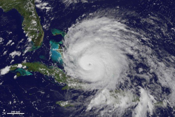
August 24, 2011 14.55 EDT Irene (taken by the GOES satellite) approaching the Bahamas. It now has a distinct eye and the clouds spiraling around the center are becoming more compact. The image also shows how large Irene has become, measuring several hundred kilometers across 

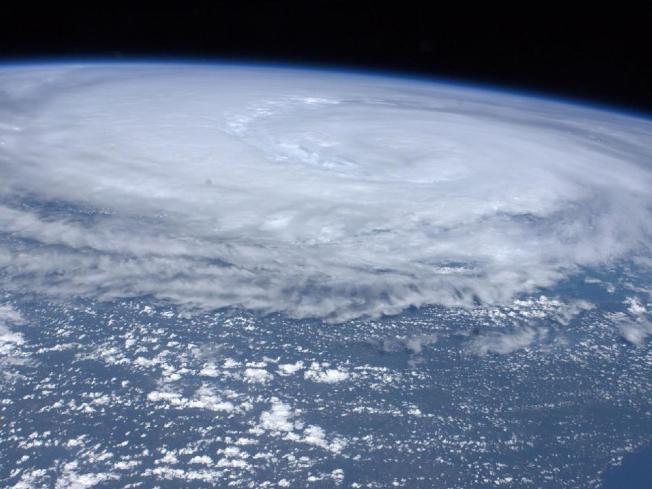
August 24, 2011 15:10 p.m. EDT View of Hurricane Irene from the International Space Station 230 miles above the Bahamas, moving northwest as a Category 3 hurricane with winds of 120 mph, expected to strengthen to a Category 4 storm imminently

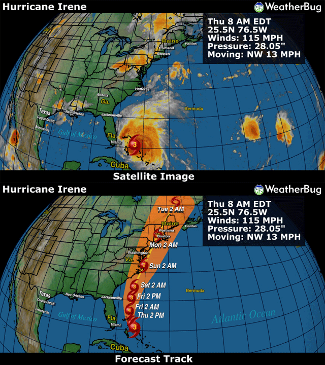
August 25 2011  8.00 EDT Hurricane Irene 65 miles east-southeast of Nassau, Bahamas. Irene’s top sustained winds remain at 115 mph, moving to the northwest at 13 mph

August 25 2011 16.30 EDT Hurricane Irene from the International Space Station, clearing the Bahamas and heading north towards the US coast

HURRICANE IRENE VIDEOS – BAHAMAS REGION

1. HOW DOES A HURRICANE FORM? Insight into the process can be gleaned by watching a rapid time lapse movie of the formation of Hurricane Irene as it sweeps northwards across the Caribbean region

2. HURRICANE IRENE FROM CARIBBEAN TO CANADA This astounding NASA video tracks the path of Hurricane Irene from August 23 to August 29, showing the formation in the Caribbean region, the path over Puerto Rico, Hispaniola, the Bahamas and the US East Coast northwards to Canada 

3. HURRICANE IRENE IN 20 SECONDS (NOAA/ GOES) A psychedelic trip

CREDITS for images, videos and text (as adapted) go to the websites of UNIVERSE TODAY,  NASA and GOES PROJECT (NASA)