HURRICANE IRMA TRACKING UPDATE: ABACO, BAHAMAS 9/9


HURRICANE IRMA TRACKING UPDATE: ABACO, BAHAMAS 9/9

It’s Saturday morning and Irma has strengthened to Cat 5 overnight as she barrels along the top of Cuba. I won’t waste words: you have better things to do than read blogs. Instead, here are some overnight tracking reports, each informative in its own way. Please note that these are a few hours old and already things will have progressed further (not least where Cat 4 is still shown). The amazing header image is from 9/7, and shows the awesome majesty of extreme weather seen from space…

Credits: NOAA with props to Randy Bresnik / AstroKomrade (1);  live tracker screenshot NotableMedia (2); Wundergroung (3, 4); NASA & partners (5). Stay safe

HURRICANE IRMA UPDATE & ISS VIEWS: ABACO, BAHAMAS


HURRICANE IRMA UPDATE: ABACO, BAHAMAS

It’s Friday afternoon. Irma is spinning her destructive progress through the Bahamas towards… well, right at the moment it seems to be Andros and then towards the Florida coast and northwards up the panhandle. Abaco is not currently shown in the direct firing line – but there’s no doubt that the passage of such a massive storm will mean plenty of dirty weather very soon now. 

I have just taken a screenshot (above) of the live tracker I am using. Top right is a realtime satellite view of Irma’s current position. Bottom left is the predicted position later this weekend. The fiercest part of the storm will have passed over Andros and carried on northwest, a path further west of Abaco than recently forecast. We must hope so, remembering of course that one location’s dodged bullet will inevitably be another’s bullseye.

In the tracker realtime shot above, it’s impossible to ignore the lurking menace of Hurricane Jose – recently graded Cat 4 – to the east. Here’s the latest Jose tracker I can find for today. Right now (but who knows for how long) this system looks as though it may hook north and expend its savage energy in the open ocean.

And here is the latest Irma tracker, as I write. It looks as if the storm may dissipate after it has made landfall at the southern tip of Florida, but it will clearly be very unpleasant down there I’m afraid.

There’s been some interest in the International Space Station ISS images I posted yesterday. The serenity of the view of a hurricane topside is so at odds with the ferocity of the weather beneath and the destruction being wrought on the ground. And they work on the imagination: suppose you were in that capsule, moving with eerie calmness through the sky, looking at the swirling mass of white cloud far below…?

Today’s screenshots were taken during yesterday’s ISS pass over Irma, using external cameras. The one below is the last in the sequence, an upside-down view looking rather like some pale alien spaceship hanging above a dark earth.

I’ll be watching events during the weekend. By the time I next write, the storm will have passed the Bahamas, and the assessments will have begun. From a safe distance of 4250 miles, I will be thinking of those who are already counting the cost; those currently enduring the brutality; and those still awaiting Irma’s malice.

THE EVIL EYE

Credits: all images ISS / NASA; live tracker from NotableMedia; tracker images for Jose & Irma from Wunderground

ABACO’S WRECKS INVESTIGATED: SS HESLEYSIDE


SS Hesleyside (wreck), Schooner Bay Abaco (Keith Salvesen) O4

ABACO’S WRECKS INVESTIGATED: SS HESLEYSIDE 

Abaco, like many of the islands of the Bahamas, has its fair share of wrecks around its shores – both ancient and modern. I reference some of these under my RANDOM menu, with some maps, links, and general information. One that I didn’t include is the SS Hesleyside, a wreck that lies broken and wave-tossed on the rocks at Schooner Bay. To reach it, you will have to arrange at the entrance for a golf-cart to take you down to the shore. The price for your transport may be an invitation to take a tour of the community there, an ambitious enterprise that was started about 10 years ago.

charlton_steamship_co_charlton_mcallum_co_ltd_charlton_w_cflag

From where the Hesleyside lies, you get a long view across to Delphi, some 3 miles to the north. Delphi Club from Schooner Bay

For the energetic, you can walk the beach of Guinea Schooner Bay all the way to Delphi. However, the unpopulated strand is covered in seaweed (good for wildlife, though) and horrendous quantities of plastic, from micro off-cuts to macro bollards, oil containers and so forth. Frankly rather off-putting.

Guinea Schooner Bay, Abaco Beach Debris, Abaco

We visited Schooner Bay on a bright day with a strong wind that whipped up the waves all along the shoreline, with clouds of spray rather detracting from the photographic possibilities. The tide was high, and the remains of the wreck were at times barely visible. 

The bow, part of the central section towards the stern, and some sort of boiler (?) at the sternSS Hesleyside (wreck), Schooner Bay Abaco (Keith Salvesen) O1 copy

charlton_steamship_co_charlton_mcallum_co_ltd_charlton_w_cflag

SS Hesleyside was a British cargo ship built in 1900 in Sunderland, England for the Charlton Steamship Co. (Charlton, McAllum). Steam-powered, the 2600 ton vessel was more than 300 foot long.  In 1908 she was was sailing from the Azores to Key West when bad weather struck, and on 1st October high winds – described in contemporary reports as a hurricane –  drove her aground where her remains now lie, a part of the coastline known as the ‘Iron Shore’. Fortunately the crew were able to escape, and there was no loss of life.

SS Hesleyside (wreck), Schooner Bay Abaco (Keith Salvesen) O7SS Hesleyside (wreck), Schooner Bay Abaco (Keith Salvesen) O3SS Hesleyside (wreck), Schooner Bay Abaco (Keith Salvesen) O5

A dramatic account of the shipwreck was published in the New York Times. The hero of the crisis was fireman Jack Thompson, who with notable courage volunteered to swim ashore with a line, by which the rest of the crew were able to make their way to safety.

Report from the New York TimesSS Hesleyside NYT report (Coconut Telegraph) jpg

charlton_steamship_co_charlton_mcallum_co_ltd_charlton_w_cflag

In accordance with standard practice, a Court of Inquiry was held in Nassau two weeks after the event to investigate the circumstances. The Master was exonerated of blame, having “tried every means of getting the ship under control without effect”.  SS Hesleyside 5 Report (Abaco Palms)

One interesting nautical and topographical note  is that the site of the wreck is described as “about 18 miles north of Hole in the Wall”. The navigational importance of HITW as a landmark was known from as early as the c17, and it was the first location to be named in the earliest maps of Abaco. For a detailed history of HITW in maps, click HERE

Nautical Map, 1856, showing the seas around ‘Le Trou dans le Mur’, and the lighthouseNautical Map 1857
Hesleyside details wrecksite.euSS Hesleyside details (wrecksite.eu / Tony Allen) [the date is wrong]

charlton_steamship_co_charlton_mcallum_co_ltd_charlton_w_cflag

WHO, WHAT OR WHERE IS HESLEYSIDE?

It’s a place in Northumberland, UK – inland, but not very from where the ship was built. Many of the Charlton ships began with an H and ended in …side. It was – and is – a common practice to have a naming theme for vessels. 

Hiram; SS 'Hesleyside'; Sunderland Museum & Winter Gardens; http://www.artuk.org/artworks/ss-hesleyside-35255

THE WRONG SORT OF HESLEYSIDE

I got quite excited when I thought I had tracked down a painting in the Sunderland Museum of the SS Hesleyside. After all, there could hardly be two steam ships with the same name, could there? Wrong. There were in fact 3 ‘Charlton’ Hesleysides in all. There is some coincidence (but not necessarily ‘irony’, Alanis Morissette) that all 3 were wrecked.

Hesleyside (1) 

86089 


1882 

688 

Ex-Turgenief, 1882 purchased from Baxter & Co, Sunderland r/n Hesleyside, 24.7.1893 wrecked at Sosnowetz.

Hesleyside (2) 

110353 


1900 

2631 

4.10.1908 wrecked at Abaco, Bahamas.

Hesleyside (3) 

133508 


1912 

3994 

1933 sold to P. Hadoulis, Andros, 1935 sold to M. Sitinas, Andros, 24.5.1940 torpedoed and sunk in 48.30N 09.30W by U.37

The rather glamourised painting shown above shows Hesleyside Mark 3 her glory days. She was built in 1912 but was sold in 1933 to a Greek company and renamed SS Kymas. Under that name she was torpedoed by a U-boat in May 1940, and 7 of her crew of 30 were killed.  The photo below (which took me a long time to decide was the same Helseyside) shows a much more steamery, freightery looking vessel… 

hesleyside_40

Sources of information: plimsoll.org; NY Times; http://wrecksite.eu / Tony Allen; coconuttelegraph.net; http://www.abacopalms.com; Wiki; Sunderland Museum http://www.artuk.org/artworks/ss-hesleyside-35255; magpie pickings from all over the place.

SEEING THE BACK OF HURRICANE JOAQUIN: LATEST UPDATE OCT 3


Hurricane Joaquin at dawn from International Space Station, Oct 2 (Scott Kelly / ISS / NASA)

Hurricane Joaquin at dawn from International Space Station, Oct 2 (Scott Kelly / ISS / NASA)

SEEING THE BACK OF HURRICANE JOAQUIN: LATEST UPDATE OCT 3

Since my post yesterday HERE confirming evidence that Joaquin was hooking out into the Atlantic and away from northern Bahamas, the storm has picked up speed as it now heads for Bermuda. It is also on a direct route to Ireland and the UK, but is already weakening. With the storm now reduced to a Cat. 3, a continuing lessening of intensity is predicted.

In this second – and, I hope, final – post of the hurricane season, the images below show the current state of play early today. I’ll repeat the weather watch links at the end.

Joaquin clears the Bahamas & heads out into the Atlantic towards Bermuda as a Cat. 3 stormHurricane Joaquin Storm path October 3

Forecast eye-path early on Oct 3Hurricane Joaquin Storm path October 3

The remarkable storm path, hooking round over Central Bahamas & going back on itseslfHurricane Joaquin Storm path October 3

The strange beauty of a hurricane captured from spaceHurricane Joaquin over central Bahamas, seen from space

USEFUL DIRECT LINKS FOR HURRICANE INFORMATION

NOAA / NHC

WUNDERGROUND

WEATHER CHANNEL

ACCUWEATHER

NASA

and for local Bahamas news

TRIBUNE 242

Credit: 'Watts Up With That

Sources: NASA, NOAA, ISS / Scott Kelly, Wunderground, Accuweather

HURRICANE JOAQUIN: LATEST TRACKING UPDATE OCTOBER 2


Hurricane Joaquin Oct 2nd 6

HURRICANE JOAQUIN: LATEST TRACKING UPDATE OCTOBER 2

There’s a great deal of information about Hurricane Joaquin flying around the internet right now, which is completely understandable. How quickly things have progressed since Irene in 2011 in the very early days of this blog, when there was little public information and an almost complete absence of information on social media. I posted daily (or more) updates as the hurricane swept up over the Bahamas. In 4 days, and despite communications being largely blanked, I had over 15,000 hits and a mass of questions along the lines ‘Any news of Treasure Cay’; ‘Can you find out how my boat is – Saucy Sue in Little Harbour’; and ‘Hi I’m on Elbow Cay, can you tell my mom in Maine that I’m ok’ [+ email]…

Here is the position today, at 05.00 EDT, according to the various resources that people turn to. Central Bahamas has taken – is taking – a battering and we have the people there very much in mind. But for the northern Bahamas the picture has improved, with the veer of Joaquin’s predicted path to the northeast increasing overnight. This does not mean an absence of strong winds and big waves – these are already being felt. But the most serious area of this Cat 4 hurricane is not expected to pass over Abaco – the direct concern of most readers of this blog. How different from Irene which wrought its havoc right over the island; and Sandy, which took much the same route.

USEFUL DIRECT LINKS FOR HURRICANE JOAQUIN INFORMATION

NOAA / NHC

WUNDERGROUND

WEATHER CHANNEL

ACCUWEATHER

NASA

and for local Bahamas news

TRIBUNE 242

Anyway, all the best to everyone affected by this fierce storm directly or indirectly, and good luck.

Credit: 'Watts Up With That

Hurricane Joaquin Oct 2nd 1Hurricane Joaquin Oct 2nd 3Hurricane Joaquin Oct 2nd 4Hurricane Joaquin Oct 2nd 7Hurricane Joaquin Oct 2nd 5Hurricane Joaquin Oct 2nd 2Sources: NASA, NOAA, Wunderground, Weather Channel, NYT, Accuweather

ABACO DAWN: WHERE NATURE MEETS ART…


Delphi Sunrise, Abaco 3

DELPHI DAWN: WHERE NATURE MEETS ART…

There’s a moment when certain photos suddenly look as if they are paintings. This may be especially true of skyscapes or seascapes – or both together. Here are some recent daybreak views from Abaco which could as easily have been painted from a bright palette. And in case you think the effects have been produced or enhanced by some photoshop-style jiggery-pokery, all these images are exactly as I downloaded them, and no ‘special effect’ settings were used to take them. I just pointed and shot… J.M.W.Turner, what could you have done with a Pentax?

Delphi Sunrise, Abaco 1Delphi Sunrise, Abaco 5Delphi Sunrise, Abaco 2Delphi Sunrise, Abaco 6Delphi Sunrise 4

HURRICANE UPDATE: GONZALO TRACKS AWAY FROM ABACO, BAHAMAS


Hurricane Irene 2011 - the eye right on course for central Abaco

Hurricane Irene 2011 – the eye right on course for central Abaco

HURRICANE UPDATE: GONZALO TRACKS AWAY FROM ABACO, BAHAMAS

STOP PRESS – UPDATE Following yesterday’s post (below), the hurricane’s tendency to track further away from the Bahamas is confirmed by later models, for examples this one from Wunderground. So I think we are officially ‘off-risk’. But Bermuda is definitely not… Anyway, read on a bit and you will find out how hurricanes get their names! 

1901289_599770936795166_5297826701188883150_n

Yesterday I posted on my FB page an NOAA hurricane tracking map update for Hurricane Gonzalo, currently rated Cat. 2 on the SAFFIR-SIMPSON SCALE. It is making its way north through the Caribbean right now, and at one stage the storm cone looked on a possible course for the Bahamas. Abaco has been spared a major cyclone for a couple of years. However memories are very recent of Hurricane Irene (2011) which passed directly over Abaco as a Cat. 3 storm; and Hurricane Sandy (2012) that passed marginally to the east with (at that stage) an intensity of a Cat. 1 before going on to wreak havoc further north. During those ‘extreme weather events’ I posted regularly about them, with tracking maps and photos. At the time of Irene there was remarkable little information around online and I got a huge number of hits – 5000+ in a day, 15,000+ in a week. I also replied to lots of inquiries from the Bahamas, US and Canada, both general (“How are things at Cherokee?”) to very specific (“Do you happen to know if my boat ‘Blowdakidzinheritanz’ moored in Little Harbour is Okay?”).

Hurricane Sandy Earth from Space 2

Hurricane Sandy over Abaco from the International Space Station

I  have been surprised at the response the map generated by way of ‘Likes’ and comments expressing relief… So from my current safe distance of precisely 4250.00 miles from Marsh Harbour, I am posting an update with helpful maps and a bit of general hurricane info. The agencies all agree that Gonzalo will hook east as it progresses northwards. The Bahamas outlook is promising, though for example Bermuda looks to be at risk.  There’s more on hurricanes on the page ABACO WEATHER. I always think that Wunderground produce the clearest maps for general purposes, though there’s a great deal more information to be had from the NOAA site, to which there’s a direct link in the Sidebar (I’ve moved it to near the top for the time being).

CURRENT TRACKING FORECASTS OCT 14 2014 

WUNDERGROUND 3-DAY TRACKING & WIND MAP at201408at201408_satat201408_radar

NOAA TRACKERS & FORECASTS

085519203828W_NL_sm

ACCUWEATHER SATELLITE VIEW & TRACKERHurricane Gonzalo Tracking Map  - clip jpg

THE SAFFIR-SIMPSON SCALE

Here is a reminder of how tropical storms and hurricanes are measured for intensity, as decreed by the S-SS, followed by the National Hurricane Center’s explanation of the gradations of relative intensities.

Saffir-Simpson Scale (Wiki) jpgT

The Saffir-Simpson Hurricane Wind Scale is a 1 to 5 rating based on a hurricane’s sustained wind speed. This scale estimates potential property damage. Hurricanes reaching Category 3 and higher are considered major hurricanes because of their potential for significant loss of life and damage. Category 1 and 2 storms are still dangerous, however, and require preventative measures. In the western North Pacific, the term “super typhoon” is used for tropical cyclones with sustained winds exceeding 150 mph.

Category   Sustained Winds Types of Damage Due to Hurricane Winds
1 74-95 mph
64-82 kt
119-153 km/h
Very dangerous winds will produce some damage: Well-constructed frame homes could have damage to roof, shingles, vinyl siding and gutters. Large branches of trees will snap and shallowly rooted trees may be toppled. Extensive damage to power lines and poles likely will result in power outages that could last a few to several days.
2 96-110 mph
83-95 kt
154-177 km/h
Extremely dangerous winds will cause extensive damage:Well-constructed frame homes could sustain major roof and siding damage. Many shallowly rooted trees will be snapped or uprooted and block numerous roads. Near-total power loss is expected with outages that could last from several days to weeks.
3
(major)
111-129 mph
96-112 kt
178-208 km/h
Devastating damage will occur: Well-built framed homes may incur major damage or removal of roof decking and gable ends. Many trees will be snapped or uprooted, blocking numerous roads. Electricity and water will be unavailable for several days to weeks after the storm passes.
4
(major)
130-156 mph
113-136 kt
209-251 km/h
Catastrophic damage will occur: Well-built framed homes can sustain severe damage with loss of most of the roof structure and/or some exterior walls. Most trees will be snapped or uprooted and power poles downed. Fallen trees and power poles will isolate residential areas. Power outages will last weeks to possibly months. Most of the area will be uninhabitable for weeks or months.
5
(major)
157 mph or higher
137 kt or higher
252 km/h or higher
Catastrophic damage will occur: A high percentage of framed homes will be destroyed, with total roof failure and wall collapse. Fallen trees and power poles will isolate residential areas. Power outages will last for weeks to possibly months. Most of the area will be uninhabitable for weeks or months.

HOW DO HURRICANES GET THEIR NAMES?

Check out the page ABACO WEATHER

BACKTRACKING

Hurricane Irene 2011 Bahamas Map Accu jpg Hurricane Sandy Map Bahamas 2012 jpg

CHILLIN’ ON ABACO VS CHILLY IN ENGLAND


CHILLIN’ ON ABACO VS CHILLY IN ENGLAND

“Life’s a beach”, it is said. On Abaco, a new season is starting at the Delphi Club, and the first guests will be sorting out their fishing tackle, reaching for the sun cream and abandoning pre-Delphi diet boot-camp. If they have been eating Marmite™ sandwiches for a week before their arrival, they won’t need  to waste energy slapping no-see-ums. The day-dreaming becomes reality, perhaps involving his ‘n’ hers rods near the rocks at one end of the beach

That’s all well and good. But in more northern latitudes the slide from summer via autumn to winter is accelerating. The trout fishing season has just ended, with my final efforts washed away by heavy rain and flooding – this photo is the road leading to one of the beats, a sure meteorological sign that a visit to the local pub would be sensible… 

A pint of beer in front of a log fire soon puts things into perspective, and the mind can wander to warmer climates, the bonefishing prospects for the season, and the calm beauty of Rolling Harbour…

Two days ago, the UK temperature dropped sharply, the skies began to clear and the sun came back. Ah! Autumn – season of tum-ti-tum and mellow wotsit… 

At one moment there was a wonderful double rainbow across the fields

This was followed by a bright starry night & the thermometer dropping abruptly to -6˚F. And then this – the first frost of the year…

  These photos are of patterns on the car roof & windscreen, before the sun thawed the ice


Brrrrrrrrr. Best not to end on a freezing note. Back to Rolling Harbour for some warmth

PINE FOREST REGENERATION AFTER FIRES ON ABACO IN 2011


Abaco Forest Fire 13

MARCH 2011 Fires swept through large areas of South Abaco, spreading rapidly and jumping the firebreak of the Highway in several places. At any one time, there were several ‘non-natural’ seats of fire. For 3 days the flames were uncomfortably close to the Delphi Club, halted only by the natural boundary between the flammable pine forest and the damper less combustible coppice. The smoke caused some amazing visual effects, especially at sunset. The first image was taken looking east from the Club verandah one evening as the fire got nearer

The vegetation alongside and between the drives was dense and lushly green before the fires. Here is a photo as fire began to take hold near the top of the drives towards the road, having jumped the Highway in the night…

As the fire rapidly spreads, this tall dead tree is actually flaming from the top

During the next couple of days, we took photographs along the drives of the apocalyptic scenes where there had so recently been impenetrable vegetation. Nearly a year later, indispensable beachcomber and photographer Kasia has taken some pictures of the drives as they are now. First, two ‘then and now’ views of the same scenes to illustrate the extent of forest regeneration

2011

2012

2011

2012

2011 The burnt-out forest between the drives

2012 A wander round the drive circuit

In some places the undergrowth has returned but trees have not recovered

Elsewhere, blackened stumps are visible in amongst the vigorous regrowth


ABACO & HURRICANE IRENE: A SCIENTIFIC RETROSPECTIVE


                    ABACO, BAHAMAS & HURRICANE IRENE                         A SCIENTIFIC RETROSPECTIVE

The contents of this post must be credited at the outset to the excellent website UNIVERSE TODAY and NASA where you can easily get Lost in Space for an eon or two. 

For 1o days at the end of August / in early September, the rh wildlife focus was supplanted by intensive weather blogging about Hurricane Irene from an Abaco perspective – the approach, direct journey north over the island, real-time reports and images of the storm and its aftermath, communication links and so forth. All from a safe distance of 4250 miles. On 26 August alone, this small blog – average daily hits 20 – had over 5000 hits…

3 months on, I have decided to revisit Hurricane Irene and the Bahamas because there is still a great deal of interest out there – I still get plenty of hits for the ‘storm posts’ – and much more available information. Some of these UNIVERSE TODAY / NASA images & videos are truly spectacular. The focus is on the 3 days August 24 – 26: before, during and after Abaco was struck by the storm

HURRICANE IRENE – ABACO / BAHAMAS SPACE PHOTOGRAPHS        (VIDEOS BELOW)

August 24, 2011 14.55 EDT Irene (taken by the GOES satellite) approaching the Bahamas. It now has a distinct eye and the clouds spiraling around the center are becoming more compact. The image also shows how large Irene has become, measuring several hundred kilometers across 

August 24, 2011 15:10 p.m. EDT View of Hurricane Irene from the International Space Station 230 miles above the Bahamas, moving northwest as a Category 3 hurricane with winds of 120 mph, expected to strengthen to a Category 4 storm imminently

August 25 2011  8.00 EDT Hurricane Irene 65 miles east-southeast of Nassau, Bahamas. Irene’s top sustained winds remain at 115 mph, moving to the northwest at 13 mph

August 25 2011 16.30 EDT Hurricane Irene from the International Space Station, clearing the Bahamas and heading north towards the US coast

HURRICANE IRENE VIDEOS – BAHAMAS REGION

1. HOW DOES A HURRICANE FORM? Insight into the process can be gleaned by watching a rapid time lapse movie of the formation of Hurricane Irene as it sweeps northwards across the Caribbean region

2. HURRICANE IRENE FROM CARIBBEAN TO CANADA This astounding NASA video tracks the path of Hurricane Irene from August 23 to August 29, showing the formation in the Caribbean region, the path over Puerto Rico, Hispaniola, the Bahamas and the US East Coast northwards to Canada 

3. HURRICANE IRENE IN 20 SECONDS (NOAA/ GOES) A psychedelic trip

CREDITS for images, videos and text (as adapted) go to the websites of UNIVERSE TODAY,  NASA and GOES PROJECT (NASA)

GREEN TURTLE CAY, ABACO 6 WEEKS AFTER HURRICANE IRENE


Michelle, a resident of Green Turtle Cay who contacted me just after Irene had hit, has emailed this update of the situation there. I’m still getting searches from people asking for news on GTC, so I’m posting this now – there may be some images to add in due course. I have a feeling that many people outside Abaco / Bahamas have no idea that the comms are still down over many areas 6 weeks later, and that the great repair and clean up continues

“Thankfully everyone is fine except for the continuous cleaning up and trying to restore the phone service.  I hear BATELNET has been sold by the gov. So there is now one hapless phone line repairman scampering around trying to get all the lines drained of water and serviceable… Irene came in on both sides and on high tide (as usual… remember Floyd?). It would have been good to have been able to receive news in the US while Irene was approaching the chain, but typical that unless it directly concerns [the US], you have to have other news sources. The patience of Bahamians is simply amazing!”

Although I have stood down from temporary hurricane-watch commentary, I will continue to post with news from individual areas for as long as I am getting online queries. All credit to WordPress for the detailed daily stats breakdowns…

 ©rh

WHALES & DOLPHINS ABACO: BMMRO BLOG – the Irene effects


 Click logo!

Charlotte Dunn has posted a report of events at Sandy Point in August on the BBMRO site. Her account includes photos of Hurricane Irene as it passed over Sandy Point, and of some of the damage in the aftermath 

For the direct link to Charlotte’s  blog  CLICK DOLPHIN ===>>> 

Hurricane Irene on its way towards Abaco, directly in its path …Image credit BMMRO

TILLOO CAY ABACO: UPDATE & IMAGES POST HURRICANE IRENE


                                                           Click me!                                                                                                          ©Brigitte Bower Carey

I have been in touch with Brigitte Bower Carey from Tilloo Cay, whose cheerful painting of a Sergeant Major graces the usual rh Logo space above. She has kindly sent an update on the post-Irene situation on Tilloo, and a couple of images showing the effects of the storm on foliage. Luckily, it sounds as though the birdlife is ok in the aftermath. But no phone, a month after…

“Everything is good here – the house and we weathered the storm just fine. The dock is a mess, but is repairable. Nothing at all like most of the south facing docks on our island and our neighbouring island, Lubber’s Quarters – only the poles survived there. So we are grateful. Still cleaning up, the yard was in bad shape, but it is coming along… Communications are a weak point here after the storms – we still don’t have our phone back.

Abaco is starting to look like in spring time now, because a lot of the foliage got burned in the 140 mph gusts of Irene. So now all of the surviving trees are pushing out new leaves, plus all the rain has helped revive things. But nothing at all like after Floyd – when we came home in November ’99 there was not a leaf on any tree, and no birds at all. So we are considering ourselves very lucky now”. 

BAHAMIAN MAHOGANY REGENERATING AFTER IRENE

A WIND-BURNED SEA GRAPE PLANT PRODUCING NEW LEAVES

Both images © Brigitte Bower Carey
www.islandwatercolors.com
www.abacoislandartists.blogspot.com

ABACO BARBS: HURRICANE IRENE VIDEO & NEWS UPDATE


I have been in touch with Mim at ARKWILD to find out the latest news on the Abaco Barbs, and in particular how things are after Hurricane Irene. She has kindly sent a brief update which speaks for itself – not very optimistic-sounding, I’m afraid: 

“Horses did fine, but we are down to the three mares inside, and one, possibly still two, stallions outside, we’re still fighting but it’s hard to paint this picture in pretty colors right now  . . .”

Mim has also sent the link to a dramatic 4 minute video which includes vivid footage of Hurricane Irene’s power as it passes over on August 25; and the aftermath on August 26 with graphic footage of damage, debris and flooding. Luckily the mares in the compound and her dogs were ok. Her boat home, well secured before Irene struck, still had various parts including its solar panels blown off, which she was fortunately able to recover by diving for them! 

CLICK IMAGE TO VIEW VIDEO===>>>  

HURRICANES: THE ESSENTIAL WHAT, WHERE AND WHY


During the recent depredations of Hurricane Irene, the news station based in Miami / F.L. was one of the very few to cover events unfolding on Abaco, with excellent live reports from Marsh Harbour as the storm passed overhead. I included the links on a daily basis during the last week in August.

It is worth saying that in addition to its normal weather coverage, the station has a dedicated hurricane section that is well-worth having a look at, and indeed keeping bookmarked for future extreme weather: CLICK LOGO===>>>

Here are the various topics that are covered at present – many people (like myself) unaccustomed to hurricanes will have wondered about many of these topics – especially some of the terminology. Click on one to find the answer! (Oh. You’ll have to endure some 15 sec ads. Sorry. Nice little Fiat 500, though!).

1. HURRICANE Q & A

Hurricane Housecall: Don’t Forget Your Roof

Hurricane House Call: Screen Enclosures

What Is A Hurricane?

When Is Hurricane Season?

Where Is The National Hurricane Center?

Who Are The Hurricane Hunters?

Hurricane Categories: Differences Between Each

What Is A Tropical Cyclone?

Do All Continents Get Tropical Cyclones?

What Is A Subtropical Cyclone?

How Do Hurricanes Form?

What Is A Cape Verde Hurricane?

What Is The Eye Of The Hurricane?

What Is The Dirty Side?

Hurricane Watch Vs. Hurricane Warning

What Are Spiral Bands?

What Is The Eyewall?

What Is A Storm Surge?

What Is The Saharan Air Layer?

Video Why Do Storms Weaken Over Land?

Year Without A Hurricane?

Should I Tape My Windows?

Should I Open Windows And Doors?

Can We Control Hurricanes?

Why Are Hurricanes Given Names?

Hurricanes Vs. Tornadoes

How Much Energy Does A Hurricane Release?

What Was The Busiest Hurricane Season Ever?

2. JUST WEATHER HURRICANE CENTER

Storm Tracker And Tropical Updates Continue reading

HURRICANE IRENE: AUG 31 ABACO AFTERMATH UPDATE, DAMAGE ASSESSMENT REPORTS


HURRICANE IRENE: LATEST ABACO NEWS UPDATE

 AUGUST 31

FOR YESTERDAY’S MAIN POST CLICK===>>> IRENE 30 AUG       See immediately below for the important Patherfinders Task Force Report links, and below that for today’s posts in reverse time order, oldest at the end.

DOWNLOADABLE  & PRINTABLE VERSION of the Pathfinders Task Force SWEAT-MS [Sewer, Water, Electricity, Academics, Transportation, Medical and Security] ASSESSMENT FOR ABACO with detailed maps and photos of supply problems caused by Irene eg Sandy Point was without electricity when assessed  CLICK===>>> PTFSWEAT-MSAssessmentAbaco

DOWNLOADABLE  & PRINTABLE VERSION of the Pathfinders Task Force RAPID DAMAGE ASSESSMENT for Abaco. The maps are incredibly helpful in revealing the extent of damage found in many areas – Marsh Harbour, Treasure Cay, Sandy Point for example – graded by severity.  CLICK===>>>  PTFRapidDamageAssessmentAbaco

=======================================================

16.00 GMT WILDLIFE NEWS: Abaco Parrots post-Irene . For a new report from Caroline Stahala, a great photo of a chick safe in its nest, and an optimistic afterword from rh  CLICK===>>> ABACO PARROT CHICK

14.00 GMT The damage assessment reports, photos and pdf download links given above are now also available on The Bahamas Weekly.com, with a comprehensive ‘SHARE’ button linking to more sharing methods than I have ever seen, let alone heard of  CLICK LOGO===>>> 

09.00 GMT  Local10.com has notified me overnight of a new short video report by Janine Stanwood on the Abaco situation. It centres (apologies for UK spelling, my spellchecker does that) on the GREEN TURTLE CLUB, GTC and on relief being flown in from South Florida by BAHAMAS RELIEF working with BANYAN AIR, including much-needed supplies for repairing properties. For the latest Local10.com report CLICK LOGO===>>>  

For direct access to the BAHAMAS RELIEF SITE / PAGE  CLICK LOGO===>>>  

rollingharbour reports… 

The situation on Abaco this week is clearer to the world, communications are mostly restored, family and friends are back in contact, and the long process of clearing up is under way. The need for the Irene side of this Abaco wildlife blog has receded. I usually get 20 – 25 hits a day for the birds, plants, reef fish and so on.  I have been getting 1000s daily since I started posting Irene radar and tracking maps and weather reports a mere 8 days ago – more than 5000 on one day alone and over 15,000 overall. The scope expanded rapidly to include links to media reports, videos, photos, damage reports and so forth. People have sought or supplied specific information. Some have said nice things. Now, however, the hit-rate has reduced to fewer than 1000 a day. Very soon it will be time for this blog, too, to return to normal service. With that in mind, here is an Abaco Parrot (taken in March 2011) to be going on with! 

HURRICANE IRENE: AUG 30 ABACO DAMAGE ASSESSMENT REPORT – ESSENTIAL READING


HURRICANE IRENE: LATEST ABACO NEWS UPDATE

 AUGUST 30 (post 2 – Pathfinders Task Force Assessments)

TO SEE TODAY’S MAIN POST 1 CLICK===>>> IRENE 30 AUG (1)

TO SEE YESTERDAY’S POST CLICK===>>> IRENE 29 AUG

21.30 GMT DOWNLOADABLE  & PRINTABLE VERSION of the Pathfinders Task Force SWEAT-MS [Sewer, Water, Electricity, Academics, Transportation, Medical, and Security] ASSESSMENT FOR ABACO. This assessment gives full details of the state of the electricity supply in the various parts of Abaco, with detailed maps and photos of supply problems caused by Irene – for example, Sandy Point was without electricity when the assessment was made…  CLICK===>>> PTFSWEAT-MSAssessmentAbaco

19.30 GMT DOWNLOADABLE  & PRINTABLE VERSION of the Pathfinders Task Force Rapid Damage Assessment for Abaco. The maps are incredibly helpful in revealing the extent of damage found in many areas – Marsh Harbour, Treasure Cay, Sandy Point for example – graded by severity.  CLICK===>>>  PTFRapidDamageAssessmentAbaco

Thanks to Bahama Islands Info for putting it in the public domain – much easier to read! TO SEE WHOLE ARTICLE CLICK LOGO===>>>  

13.00 GMT  HURRICANE IRENE ABACO DAMAGE ASSESSMENT REPORT (29 AUG)       ESSENTIAL READING

I have already provided the links to this report in my earlier post today. This one deserves its own space. Over the past few days I’ve had a vast number of hits from searches including the words ‘Abaco’, ‘Irene’, and ‘Damage’ in various combinations. Clearly many people are desperate for information, especially as communications have been down completely in many places, and very variable elsewhere. Now at last there is available a detailed preliminary assessment of Irene damage on Abaco, with a report, maps and photographs, posted on BAHAMASLOCAL.COM  It will be of great interest to everyone on Abaco or elesewhere concerned to find out more about the effects of Irene on the Islands and Cays. I will add anything else that arises later today to the main post of today (see top of page for LINK), but I thought this report merited its own publication and title tags (for Google purposes). CLICK==>> BAHAMAS LOCAL 

HURRICANE IRENE: AUG 30 ABACO UPDATE, DAMAGE REPORT, STORM VIDEOS


HURRICANE IRENE: LATEST ABACO NEWS UPDATE

 AUGUST 30

TO SEE YESTERDAY’S POST CLICK===>>> IRENE 29 AUG

21.30 GMT DOWNLOADABLE  & PRINTABLE VERSION of the Pathfinders Task Force SWEAT-MS [Sewer, Water, Electricity, Academics, Transportation, Medical, and Security] ASSESSMENT FOR ABACO This assessment gives full details of the state of the electricity supply in the various parts of Abaco, with detailed maps and photos of supply problems caused by Irene – for example, Sandy Point was without electricity when the assessment was made…  CLICK===>>> PTFSWEAT-MSAssessmentAbaco

19.30 GMT DOWNLOADABLE  & PRINTABLE VERSION of the Pathfinders Task Force Rapid Damage Assessment for Abaco. The maps are incredibly helpful in revealing the extent of damage found in many areas – Marsh Harbour, Treasure Cay, Sandy Point for example – graded by severity.  CLICK===>>>  PTFRapidDamageAssessmentAbaco

Thanks to Bahama Islands Info for putting it in the public domain – much easier to read! TO SEE WHOLE ARTICLE CLICK LOGO===>>>  

17.00 GMT NASSAU GUARDIAN ARTICLE published this morning LT “HURRICANE IRENE & BEING PREPARED”, general summary of the situation. CLICK LOGO===>>>  or The Nassau Guardian

14.30 GMT STORM VIDEOS A number of short Abaco-specific hurricane videos are beginning to appear on YouTube of the storm and its aftermath, suggesting that comms must be pretty much back to normal. If you are looking on YouTube or its equivalents, use the ‘advanced search’ to specify date order, or you’ll get a lot of pre-Irene items that you have already lived through. The link here will take you direct to the latest videos, sorted in upload order, with the most recent at the top. I hope. CLICK===>>> ABACOonYOUTUBE

10.30 GMT STOP PRESS – HURRICANE IRENE ABACO DAMAGE ASSESSMENT REPORT (29 AUG) This is a detailed preliminary assessment of Irene damage on Abaco, with a report, maps and photographs, posted on Bahamas Local. Essential reading CLICK==>> BAHAMAS LOCAL 

DELPHI CLUB NEWS: I’ve just heard from Peter Mantle, with the good news that the team are all back at the club now, and the great clear-up is well under way

10.00 GMT Another video today of the arrival of Irene, this time from Cooperstown, North Abaco. Poster Jack Slack says “Initially the camera point of view is primarily facing East (Powell, High and Bonefish Cays) and then later pans across Cooperstown Clinic. About 1 minute into the clip, she starts blowing pretty hard… CLICK===>>> SLACKTIDE

09.00 GMT HOPE TOWN IRENE VIDEO There is now an excellent video with fascinating commentary on STORMVISUALS (Jeff Gammons). There is a direct link contained in the description below it to blog posts during Irene. There are are also a number of comments on the page which some may find useful. To get to the video CLICK==>> STORMVISUALS or TWEET WIDGET in Sidebar. Also here’s the link to the Facebook part of STORMVISUALS CLICK==>>FBSV

New Amazing Hurricane Irene Video From Great Abaco / Hope Town
“Earlier this afternoon, I finally received some of the raw Hurricane Irene video footage from Hurricane Chaser Jim Edds in Hope Town, Bahamas. Category 3 Hurricane Irene’s eye tracked directly over Great Abaco Island and Elbow Cay, and Jim was there to film it yesterday afternoon. He was also able to give me a rundown via cell phone of the peak of the storm, and how the island is doing the day after Irene, and I have including that audio in the video above. Look for additional video from Jim in the coming days when he returns to Florida this weekend. You can also read the blog posts updates during the storm yesterday here”

FROM YESTERDAY For those wondering what Rolling Harbour is all about, here is a view of it – a Google Maps image taken just before building started, over which I have superimposed a picture of the Delphi Club. Last Thursday, the sea covered all the visible sand and beyond into the scrub, with waves smashing up against the cliff-face. The wooden steps to the beach (on the right of the photo), although robust, were expected to be smashed completely, but amazingly they have survived intact. Double-click to enlarge.

USEFUL:  Local10.com has been excellent in its reporting of Abaco and Irene, with first-class live open-air reports from Janine Stanwood while the storm raged around her, and informative, balanced studio coverage. Here is the link to the recent 39-images slideshow. Some are captioned with location            CLICK==>> LOCAL10 

Delphi Club Abaco 25 Aug 2011 / Hurricane Irene: Looking north to the end of the bay

The Palm Tree in photo above, in less adverse weather

HURRICANE IRENE: ABACO NEWS UPDATE AUG 29… WILDLIFE EFFECTS?


HURRICANE IRENE: LATEST ABACO NEWS UPDATE

AUGUST 29

TO SEE YESTERDAY’S POST CLICK===>>> IRENE 28 AUG

22.00 GMT Here’s the link to 4 very short video clips from ‘Capt-Chris’ in Marsh Harbour CLICK===>>> MH CLIPS 

For those wondering what Rolling Harbour is all about, here is a view of it – a Google Maps image taken just before building started, over which I have superimposed a picture of the Delphi Club. Last Thursday, the sea covered all the visible sand and beyond into the scub, with waves smashing up against the cliff-face. The wooden steps to the beach (on the right of the photo), although robust, were expected to be smashed completely, but amazingly they have survived intact. Double-click to enlarge.

19.00 GMT I notice I have been getting a great many hits from searches with the format ‘Abaco…damage…[place]’. Local10.com has been excellent in its reporting of Abaco and Irene, with first-class live open-air reports from Janine Stanwood while the storm raged around her, and informative, balanced studio coverage. Here is the link to the recent 39-images slideshow. Some are captioned with location  CLICK==>> LOCAL10 

Meanwhile, according to travel sites, Hotels & Resorts on Abaco have been confirming minimal damage  to buildings – nothing structural so far, anyway – and problems confined in various degrees to the “landscaping”. The overall picture is “open for business”

16.00 GMT a message (thanks, Susan) reads “…thanks for the info. We live if Fl and have dealt with more than a few hurricanes. I love Rolling Harbour and the Delphi [Club] is beautiful – the beach is stunning. Good luck with the clean up and thank you again for your site. I hope the parrots did well – they were finally coming back after the beating they took from Hurricanes Floyd and Frances“.

I am hoping to be able to post about the parrots once Caroline Stahala has had a chance to make an assessment of the situation. Having just finished the chick banding project (see ABACO PARROT CHICK BANDING with unique photos) they must be at the forefront of her mind: she has been engaged in their research and conservation for several years. As for other wildlife, wearing my more natural-fitting blog hat I am hoping to have some news from Ricky Johnson once he too has a chance to get out there and see the effects of the Irene on the birds.

At least we know the W I woodpecker family at Delphi are (probably) ok… here’s a picture (the subject of a caption competition) from a while back to add some cheer with their comic behaviour  (photo credit David Rainford)

14.00 GMT: Back home in London. I have at last had some news from Long Beach, about which there have been queries. Phone calls are now getting through and the damage news from there is “except for some downed trees everything is ok”. Thanks, Elizabeth. Perhaps that is optimistic for comms for most if not all of South Abaco today – and hopefully elsewhere.

Online, there hasn’t been much new activity – still very few storm images (apart from weather maps / satellite images from last week). The ones from this blog are all there now. And very few videos beyond those I have already given the links to. Press reports are, as you might expect, concentrate on what did – or didn’t – happen in NYC yesterday. I’ll check later for updates, but I have a feeling that as links are gradually restored, my storm-related usefulness is coming to an end. Soon I’ll be back to reporting on parrots, reef fish and cone shells… 

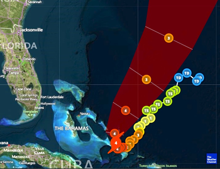
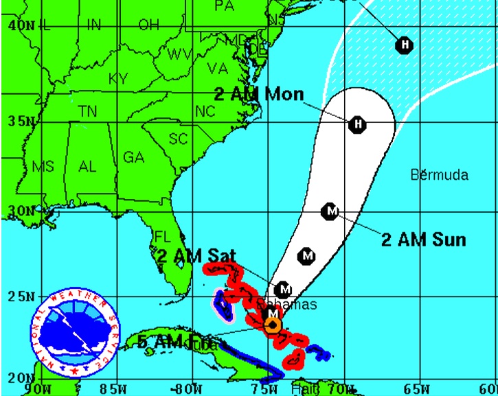
09.30 GMT: Post haste: I am travelling this morning. and will post anything of note later on. I’ll be interested to know how things are going, and whether communications are getting back to normal. Please feel free to leave any useful info in the comment box at the bottom, which others can then see. Here a a few items from yesterday’s post to be going on with

  CLICK LOGO ===>>> 

   CLICK LOGO===>>

09.00 GMT: NEWS FROM THE DELPHI CLUB, ROLLING HARBOUR SOUTH ABACO 

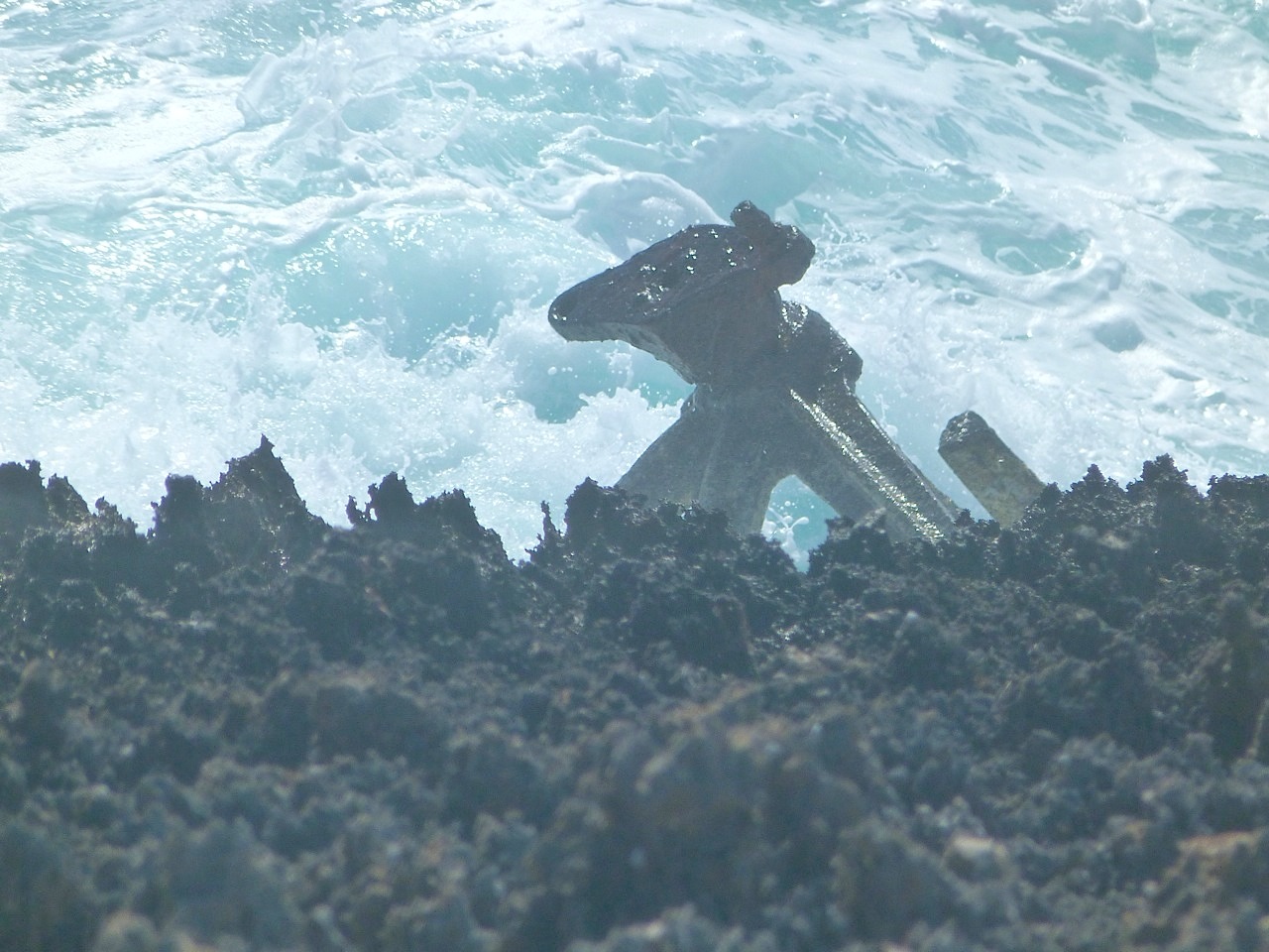
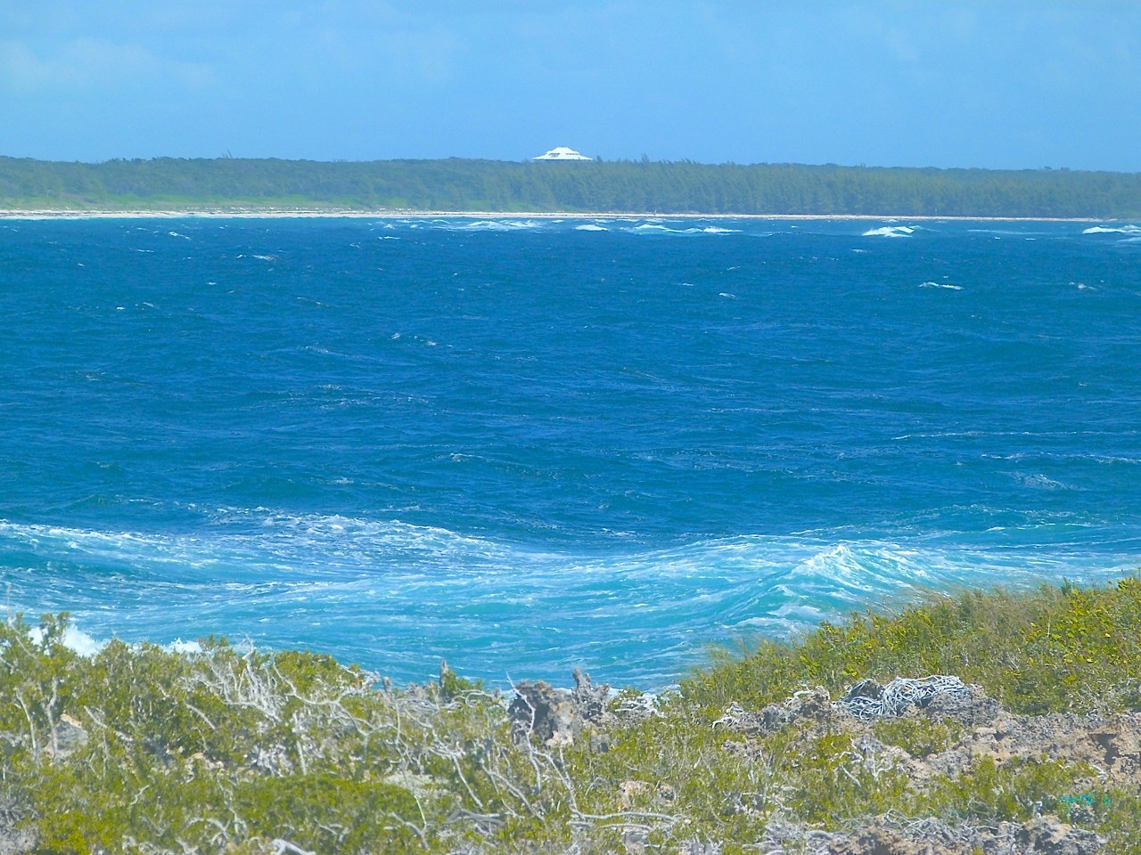
Caroline Stahala reports: “Now the clean up begins. We were very lucky but it will still be quite an extensive recovery process.  Even though the house seemed to have withstood the high winds and rain, many of the trees and other vegetation were not as fortunate. And as with most hurricanes, we are bound to see more loss of vegetation and defoliation over the next few weeks. But since you are running a natural history blog, I thought I would add a bird note to the story. So, I have mentioned the woodpeckers that have chicks in the house Sandy built. Well, these birds deserve to be recognized as parents of the year. During a Cat 3 hurricane, the parents were out looking for food for the chicks.  I am attaching a picture of the woodpecker dad waiting for an opportune time to fly out during the eye of the storm.  I am also attaching some hurricane pictures taken from a safe spot during the storm. I appreciate all of your thoughts and well wishes. Crazy experience to say the least.”

Here are her excellent photos (© Caroline Stahala – please credit her if you use them), followed by 3 of my own of them same views taken in March 2011

Delphi Club Abaco 25 Aug 2011 / Hurricane Irene: Looking south from the balcony

Delphi Club Abaco 25 Aug 2011 / Hurricane Irene: Looking south across the pool area

Delphi Club Abaco 25 Aug 2011 / Hurricane Irene: Looking north to the end of the bay

Delphi Club Abaco 25 Aug 2011 / Hurricane Irene: Looking south to the end of the bay

Delphi Club Abaco 25 Aug 2011 / Hurricane Irene: Father woodpecker stands guard over the chicks

The Palm Tree in photo 3 above, in less adverse weather

Delphi Club: the beach looking north (storm photo 3)

Delphi Club: looking south over the pool area (see storm photos 1,2 & 4)

HEADLINEGRABBER Marsh Harbour feature 27 Aug  CLICK===>>> HERE

 (CLICK LOGO LINK) a useful resource for updates. I have put the link the Sidebar Twitter section for those that may want to Retweet the link.

HURRICANE IRENE: ABACO NEWS UPDATE and 5* IMAGES AUG 28 from Delphi Club, Rolling Harbour


HURRICANE IRENE: ABACO NEWS UPDATE        AUGUST 28 [for news update Aug 29 CLICK==>HERE]

22.30 GMT: No additional Abaco news. Time to sign off unless I get any further info by email… until tomorrow. Meanwhile, good luck with the clear-up…

20.00 GMT: There’s a new short report on the DELPHI CLUB website, for those keeping an eye on Rolling Harbour rolling news… It basically cross-refers to this Post (which can be reached direct from the Delphi website) and the vivid images, adding: “In essence, all is well. But there will be lots of clearing up to do”. 

19.00 GMT: Not much to report, except that my impression is that communications are gradually being re-established on Abaco. I notice the Rocky Bay webcam on Elbow Cay is still down, but I doubt it’s a priority right now…I have sent out a few inquiries, and am waiting responses which I will post as and when. Meanwhile there is a new post from Conch Salad TV – a site many Abaconians will be familiar with – that includes video clips of Irene from last week   CLICK LOGO ===>>> 

14.00 GMT: The media focus has pretty much left the Bahamas in its wake, much like Irene itself. Very little online material that adds anything. However, Firefly Sunset Resort in Hope Town is posting regular updates on its Facebook page, including images of the aftermath of Irene.The message boards below may also help those seeking Elbow Cay information                                                          CLICK LOGO===>>

09.00 GMT: STOP PRESS NEWS FROM THE DELPHI CLUB, ROLLING HARBOUR SOUTH ABACO I have just heard from Caroline Stahala at Delphi, where some comms have now been restored. She has been on guard throughout. Those familiar with the day-job of this blog – Abaco wildlife – will know that she is a research scientist heading the project dedicated to the conservation of the Abaco Parrot. Put her name in the search box – or ‘Abaco Parrots’ –  and the relevant POSTS will come up. 

Caroline reports: “Now the clean up begins. We were very lucky but it will still be quite an extensive recovery process.  Even though the house seemed to have withstood the high winds and rain, many of the trees and other vegetation were not as fortunate. And as with most hurricanes, we are bound to see more loss of vegetation and defoliation over the next few weeks. But since you are running a natural history blog, I thought I would add a bird note to the story. So, I have mentioned the woodpeckers that have chicks in the house Sandy built. Well, these birds deserve to be recognized as parents of the year. During a Cat 3 hurricane, the parents were out looking for food for the chicks.  I am attaching a picture of the woodpecker dad waiting for an opportune time to fly out during the eye of the storm.  I am also attaching some hurricane pictures taken from a safe spot during the storm. I appreciate all of your thoughts and well wishes. Crazy experience to say the least.”

And here are the graphic pictures. There are very few images from Abaco online yet – no doubt because comms are down – so it’s worth pointing out that these are from a place over which the eye of the storm passed directly. I should add that these images are © Caroline Stahala – please credit her if you use them

Delphi Club Abaco 25 Aug 2011 / Hurricane Irene: Looking south from the balcony

Delphi Club Abaco 25 Aug 2011 / Hurricane Irene: Looking south across the pool area

Delphi Club Abaco 25 Aug 2011 / Hurricane Irene: Looking north to the end of the bay

Delphi Club Abaco 25 Aug 2011 / Hurricane Irene: Looking south to the end of the bay

Delphi Club Abaco 25 Aug 2011 / Hurricane Irene: Father woodpecker stands guard over the chicks

The Palm Tree in photo 3 above, in less adverse weather

Delphi Club: the beach looking north (storm photo 3)

Delphi Club: looking south over the pool area (see storm photos 1,2 & 4)

08.00 GMT: Hi on Sunday 25 Aug. I have had a quick look online to see what new information there may be… here are a couple of items to be going on with.

HEADLINEGRABBER has a Marsh Harbour-based feature posted yesterday 27 Aug at 12.18 pm LT CLICK===>>> HERE

 (CLICK LOGO LINK) looks a useful resource for updates from contributors, e.g. “At Marsh Harbour airport they had  minimal structural damage.” I have also put the link in a Tweet in the Sidebar Twitter section for those that may want to Retweet the link.

Finally for now, here is an image from the Australian Telegraph that vividly shows Irene’s track over the Bahamas