
I have posted several times about Hole-in-the-Wall, the geological feature and historic nautical landmark at the southern tip of Abaco. I’ve covered the frankly concerning 15-mile trip to reach it and the eponymous lighthouse; its history in both maps and pictures; and its destruction by Hurricane Sandy last October. A full index of the related Hole-in-the Wall posts can be found at the foot of this page (most recent first). I am returning to one specific early picture of HitW because of interesting information supplied by Capt Rick Guest.
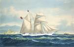
THE PICTURE The lovely aquatint below is by J. Wells, based on a sketch by a naval officer (“Half-Pay”), published in the 1803 NAVAL CHRONICLE by founder J.Gold of Shoe Lane, London. It’s quite small picture, measuring 5½” x 9″. As I said in the original post, “you may be looking at a screen clip of a scan of the book plate of the earliest surviving depiction of Hole-in-the Wall. If anyone knows of an older one, please get in touch. And can anyone identify what kind of sailing vessels these are (I wouldn’t know a brigantine from a clipper…)?”.
THE SHIPS I am now better informed about historic ships (though no wiser). I am very grateful to Rick Guest for his various contributions, including his ID of the ships in the aquatint: “The vessel on the left (west) is a Topsail (‘tops’l’) SCHOONER. Because of the angle on the other vessel, my guess is it’s a BRIG. Brigs have 2 masts, usually with a large ‘Spanker’ (aft sail).” The schooner is flying the Union Jack. The two rowing boats setting off from the ships seem from the detail to be heading towards land – perhaps to find fruit or other provisions.

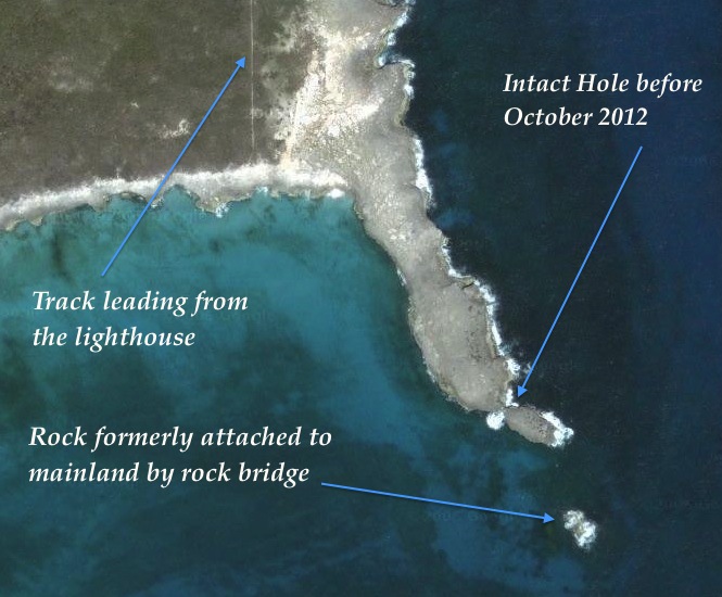
THE GEOLOGY Besides showing Hole-in-the-Wall between the 2 ships (as it was until Hurricane Sandy struck in October 2012), there is an additional feature that I did not originally remark on. To the right of the aquatint is a single rocky islet. Its left side and the corresponding end of the mainland clearly evidence the previous existence of another longer-arched hole, its roof presumably long gone by 1803. Earlier maps make no reference to a second Hole, though it’s possible the oldest refer to the larger, more significant hole until it collapsed and left the smaller hole to bear the name. At all events, the islet to the right in the aquatint is now largely submerged, though it can be seen from an aerial view. If anyone has a photo of it taken from the sea, with the promontory and lighthouse behind, please get in touch.
MAPS
I have found some more images of historic maps of Abaco to add to the earlier collection.
1. Johannes van Keulen 1728 c17/ early c18 Dutch cartographer. The top image of two is from a less well-reproduced edition, possibly an early one. The HitW area is uncompromisingly called ‘Hole Rok’. This is a rare instance of another ‘Hole Rok’ being marked of the south-west tip of Abaco. The main island itself is often described at this time as I. Lucaj(y)onesque, or similar derivative from the word ‘LUCAYA’ (Lucyan people being the early inhabitants of the Bahamas region). Notable here is the use of the word ‘I. Abbaco’ for a cay on the east side rather than the whole island.
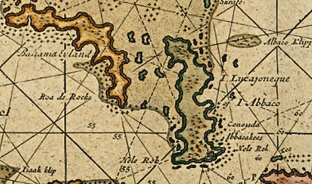
This second much clearer (and later?) print of the same van Keulen map demonstrates why Hole-in-the-Wall is of such historic importance to the Abacos. It clearly marks the only settlement of any significance known to seafarers and cartographers of the time. Other contemporary maps are the same. It is the only named place on Abaco. Buildings are even shown here, though nowhere else on the island. It may well be fair to conclude that until at least 1800, HitW was the ‘capital’ of Abaco. Nowadays it is simply a functioning lighthouse in urgent need of attention and repair, with the abandoned buildings of the lighthouse station clustered round it (the light was automated in 1995). There is no settlement and there are no dwellings, not even visible ruins.
2. Thomas Kitchin 1782 Kitchin was a well-known English c18 cartographer who famously mapped the counties of Britain. He also worked in the Caribbean for a time. The clip below is taken from his map “West Indies according to Best Authorities“. The image doesn’t do the map justice. I own it (thanks, Mrs RH) and had just framed it when someone asked for a quick photo, so it is taken through glass (too lazy to remove it – will try to improve the image later). Great Abaco is now specifically named in its own right as an island, though the Abacos group as a whole retains its historic Lucayan name. Again, ‘The Hole in the Rock’ is the only place-name included. As a side-note, Grand Bahama has progressed from ‘Bahama Eyland’ to ‘Great Bahama’
3. B.T.Welch, published F.Lucas Jr 1823 The top map shows the entire West Indies. I have located a clearer version of it and added the clip below it showing the detail of the top left corner Northern Bahamas corner
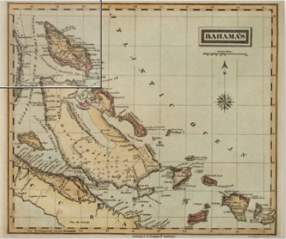 One hundred years on from the van Keulen map, and a few familiar names are starting to appear, especially with the ‘Kays’. ‘Hole of the Rock’, as it was now called, is still almost the only named place on the main island. I can’t make out what the bearing and date under the name means – any suggestions welcome. In passing, I note that ‘Gordo K(ay)’ is named, the earliest mention I have found. It is now of course ‘Disney Island’, and good luck to it… ‘Great Bahama’ has now become. finally, Grand Bahama.
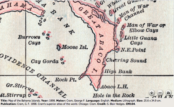
4. George Cram 1898 This map demonstrates how, even in relatively modern times, mapmakers can take their eye off the globe, as it were, and go wrong. True, ‘Hole in the Rock’ is named and its lighthouse (completed 1836) is marked. However, some of the attributed place-names seem surprising – for example, Moore’s Island has strangely been called Moose Isl. And for a map not much more than 100 years old, in the ‘Superior Atlas of the World‘, the general topography of Abaco is way off the mark. Either that or the Crossing Rocks area in the lower quarter of the island below “Cheering Sound” – a slim land-narrow just few metres wide from east to west coast – has been on a crash diet in the intervening century… It’s basically the width of the road with a beach on either side.
LIST OF PREVIOUS HitW POSTS
HOLE-IN-THE-WALL, ABACO: THE ‘HOLE’ THAT’S NO LONGER A WHOLE December 9, 2012
HOLE-IN-THE WALL ABACO: “MIND THE GAP” – A NEW ISLET IS BORN November 8, 2012
ABACO’S ‘HOLE-IN-THE-WALL’ BEFORE SANDY DEMOLITION: FIRST & LAST EVER IMAGES November 5, 2012
HOLE-IN-THE-WALL TO GAP-IN-THE-WALL: HURRICANE SANDY SMASHES ABACO LANDMARK November 3, 2012
HOLE-IN-THE-WALL ABACO: HISTORIC 1803 DESCRIPTION & AQUATINT May 23, 2012
ABACO & HOLE-IN-THE-WALL, BAHAMAS: A SHORT HISTORY IN MAPS April 8, 2012
“TO THE LIGHTHOUSE…” A TRIP TO HOLE-IN-THE-WALL, ABACO May 25, 2011


")


You must be logged in to post a comment.