HOLE-IN-THE-WALL, ABACO: A UNIQUE PERSPECTIVE (2) PRESENT & FUTURE


Winslow Homer G W Original Brooklyn

HOLE-IN-THE-WALL, ABACO: A UNIQUE PERSPECTIVE (2) PRESENT & FUTURE

Following on from my post last month HOLE-IN-THE WALL: THE PAST, it’s time to take a closer look at the ‘Gap-in-the-Wall’ as it is today, viewed from the sea. I’ve called this a ‘unique perspective’, but I’m sure many people have taken photos of HITW from the sea. It just that apart from a few kayaking ones from before the collapse of the arch, I haven’t found them. So I took some, thanks to the BMMRO and their research RHIB. 

Hole-in-the-Wall Abaco (2015-2) 01 Location photo map

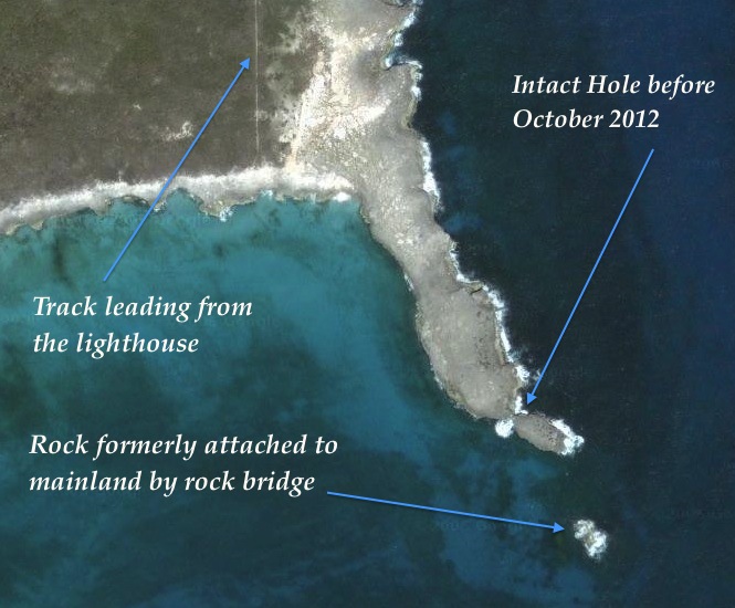
The view above is taken from some way to the west of HITW, and I have marked the main features that will be shown in this post. As one approaches the promontory, the lighthouse and its outbuildings are the only sign of human intervention to be seen in the landscape. Historically there were small settlements in this remote place, and some traces of these remain.

Hole-in-the-Wall Lighthouse Abaco (sea view)

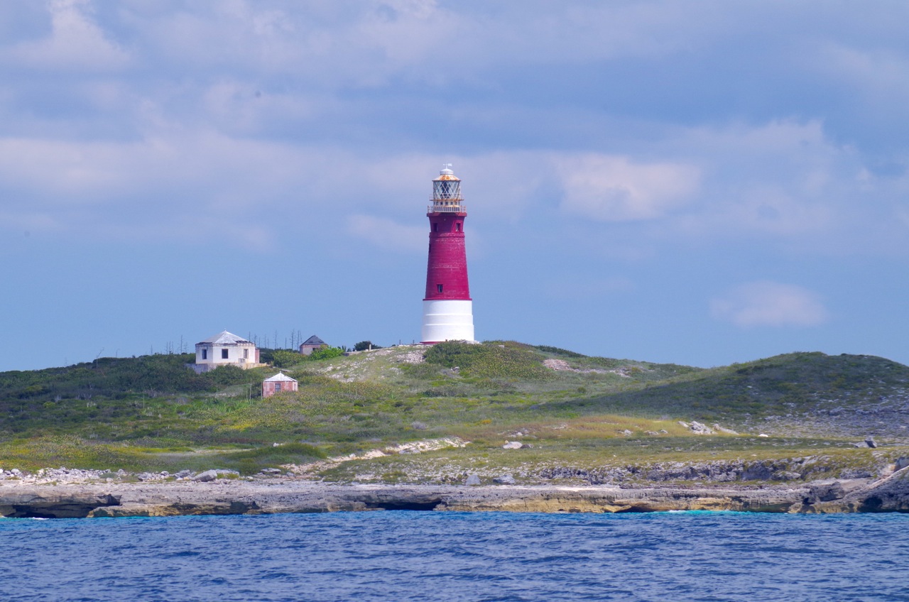
Closing in on the former ‘Hole’, fresh damage from Hurricane Sandy’s destruction of the arch is still visible. It is more conspicuous on the other side.Hole-in-the-Wall Abaco (2015-2) 03 Collapsed arch (Hurricane Sandy)

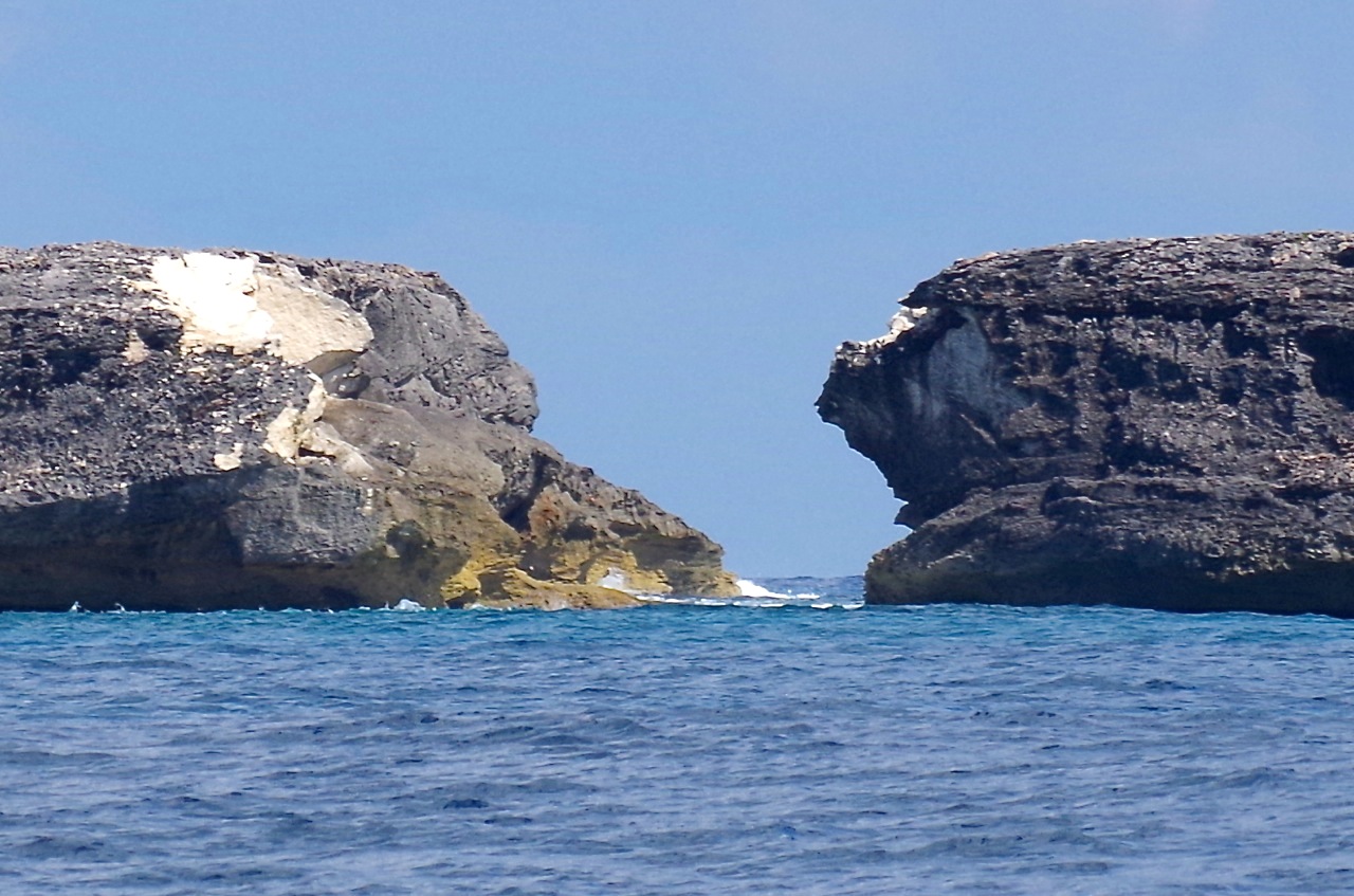
In this photo, you can follow the features from the lighthouse to the foreshortened promontory, the new gap, the small islet that now exists, and finally a small eroded outcrop of rock – the remains of an extension of the mainland, and probably evidencing the southern tip of another arch that collapsed centuries ago.Hole-in-the-Wall Abaco (2015-2) 04 Light, hole and outcrop

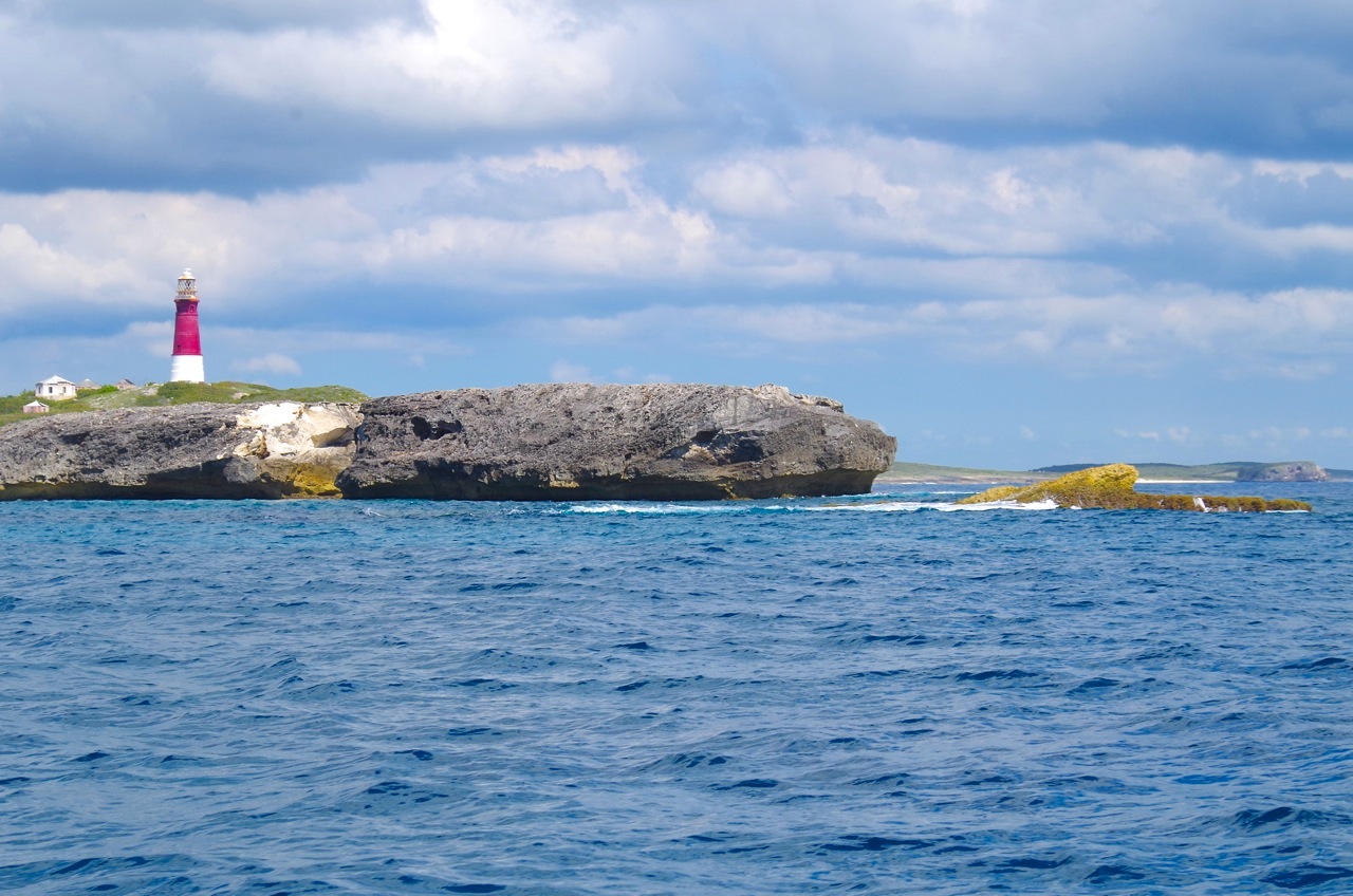
Passing the outcrop and round to the east side of the promontory, further evidence of fresh damage can be seen, with the main shear being on the north side of the arch.Hole-in-the-Wall Abaco (2015-2) 05 Hole-in-the-Wall Abaco (2015-2) 09Hole-in-the-Wall Abaco (2015-2) 07Hole-in-the-Wall Abaco (2015-2) 10

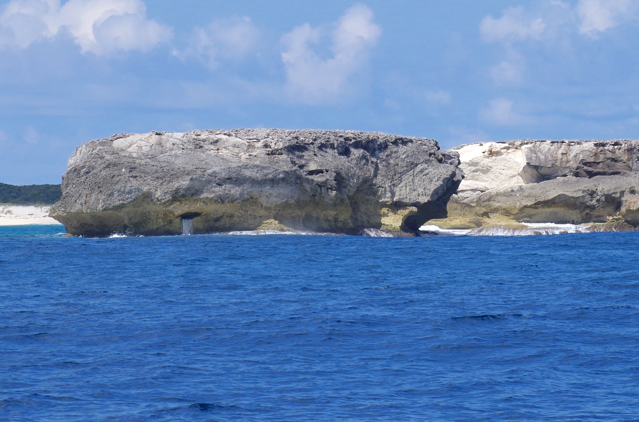
There’s a fine view of the lighthouse from the east Hole-in-the-Wall Abaco (2015-2) 11

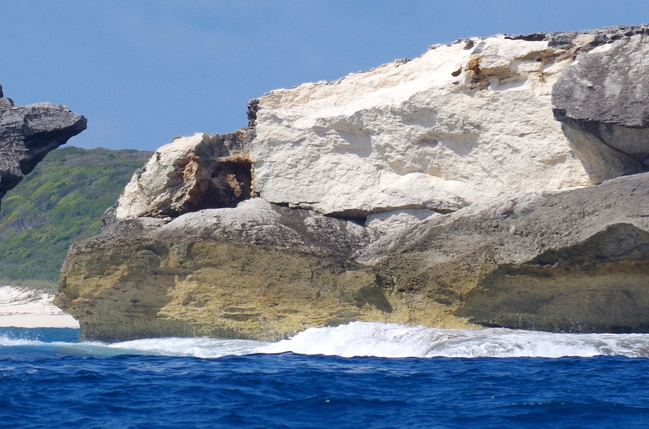
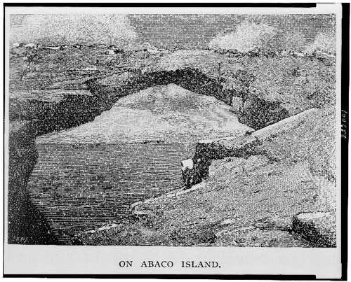
As we started the return journey to Sandy Point via groups of whales and dolphins, we went close to the outcrop, land’s end (next stop, Nassau). Even on a calm day, it is still thrashed by waves, as the second photo shows: no wonder it has eroded so quickly…  See how it looked in the 1803 aquatint below, from which one can see how there must have once been an even larger ‘hole in the wall’ way back in history and long since collapsed even by then. Hole-in-the-Wall Abaco (2015-2) 12 Hole-in-the-Wall Abaco (2015-2) 13Hole in the Wall Print 1803

Then it was time to move on, having been fortunate enough to see the location from an entirely new angle
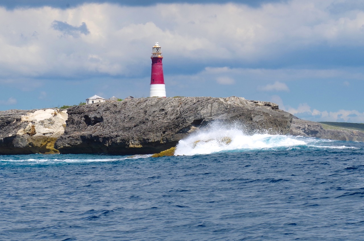
Hole-in-the-Wall Abaco (2015-2) 14Hole-in-the-Wall Abaco (2015-2) 15

THE FUTURE

The geological future of the Hole-in the-Wall landscape is presumably that erosion and rising sea levels will sink the outcrop below the waves; the islet left after the collapse of the arch will similarly erode over the centuries, as in time will the whole promontory. Maybe as it gets thinner, another hole will be worn through by the waves. The restoration of the lighthouse, long promised, may perhaps take place. The nautical importance of the area suggests that the historic need for a light as both landmark and warning will continue. And who knows: even now, plans for wholesale redevelopment of the area could be on a drawing board somewhere…

Hole-in-the-Wall Lighthouse Abaco (Notice) hitw9

WINSLOW HOMER

The header image is the well-known watercolour by Winslow Homer (1836 – 1910), the original of which is in the Brooklyn Museum. It was painted in 1885 and is entitled ‘Glass Windows’. This is commonly claimed to be the famous ‘Glass Window’ feature on Eleuthera. However my own theory is that it in fact depicts Hole-in-the-Wall, Abaco. There are a number of good reasons for this, but the most immediately striking is the title Homer himself gave to an engraving of the identical view, published in The Century magazine (Feb 1887). This engraving pre-dates, and was clearly the template for, the watercolour. The rock structure and even the cloud formations are identical. And the title “On Abaco Island” seems conclusive of the location.

Hole-in-the-Wall Picture

Credits: All photos, RH; Winslow Homer painting, Brooklyn Museum online archive

HOLE-IN-THE-WALL, ABACO: A UNIQUE PERSPECTIVE (1) THE PAST


Map of Abaco (part) - van Keulen 1728

HOLE-IN-THE-WALL, ABACO: A UNIQUE PERSPECTIVE (1) THE PAST

I’ve posted several times about the desolate, unpopulated area on the southern tip of Abaco known as Hole-in-the-Wall. It’s a place of history and mystery – indeed arguably the most historically, geographically and nautically important location on the entire island. The material in this post has to an extent been combined from earlier posts a couple of years back, since when a great many more people have been showing an interest in the wildlife and history of Abaco (thanks!) and may be new to the history and significance of HITW…

Although Abaco is identifiably – though not geographically reliably – mapped from as early as 1550 (only 58 years post-Columbus), the earliest map of Abaco showing any actual named place is the van Keulen map of 1728 in the header picture. The importance of HITW (‘Hole Rok’ marked on the east side) is clear. Indeed it is the only settlement shown. Thereafter, the place is mapped variously as Hole-in-the-Rock, Trou dans la Roche and Hole-in-the-Wall, before finally settling on the last name. HITW was clearly a significant nautical landmark from at least the c16. You can read more on this topic at HITW – A SHORT HISTORY IN MAPS

Incidentally, note the early spellings including of the word ‘Cay’ as ‘Kee’ in the bottom right corner – doubtless an explanation for the pronunciation today, when one might otherwise rhyme the word with ‘Bay’.

hole-in-the-wall-print-1803

The print above, dated 1803, is the earliest depiction of HITW that I have traced. For now, note the familiar ‘Hole’ between the two ships; and the outcrop to the right showing that another, larger ‘Hole’ had, by the early c19, collapsed. Remains of the outcrop, now badly eroded, can still be seen. Read more about pictures of HITW in SHIPS, MAPS & HITW , or in HOLE TO GAP, including a more recent print by Winslow Homer (below) which I contend is the proof that his famous painting ‘Glass Window’ in the Brooklyn Museum is of Abaco and not (as claimed elsewhere) the famous Glass Window on Eleuthera. Of which more another time…

Hole-in-the-Wall Picture

The sad fact is that although the name lives on and probably always will, in October 2012 Hurricane Sandy smashed the Hole in the Wall to smithereens, leaving what one can best describe as GAP IN THE WALL.

Here is the position of the Hole, shown before Sandy struck. Note the outcrop at the tip (bottom right corner), as seen in the old print above hole-in-the-wall-rock-abaco-location

One of very few photos taken from the sea that I have come across. There’ll be more, and much closer, in the next post Hole-in-the-Wall distance shot

The view from the lighthouse down to the ‘Land’s End’ promontory (RH)Hole-in-the-Wall Lighthouse Abaco (Keith Salvesen)

An aerial view of ‘Land’s End’ (with thanks to marinas.com for free use permission)Hole-in-the-Wall Lighthouse, Abaco annotated

The Hole, very shortly before Hurricane Sandy blasted away the bridge – the perfect place for a picnic…Hole-in-the-Wall Abaco ©Jessica Arrington

Or, as the storm approaches, maybe not…. Jack Bowers took this wonderful (and dangerous to acquire) sea-level shot – possibly the last photo ever of the intact arch427937_4820129308023_1041770732_n

Photos of the ‘Ex-Hole Now Gap’ taken within a very few days of the storm. Note the pale fresh stone HOLE-IN-THE-WALL ABACO post Sandy 1 Luc LavalleeHOLE-IN-THE-WALL ABACO post Sandy 2 Luc LavalleeHOLE-IN-THE-WALL ABACO post Sandy 3 Tara Lavallee

This post covers the history of Hole-in-the-Wall over the last 400 years or so, with links to earlier posts from a couple of years back. Then there’s a bit of a gap, I’m afraid, back to the LATE PLEISTOCENE EPOCH roughly 125,000 years ago when the landmass was formed… 

PART 2 will show how the ‘Hole’, the promontory and the lighthouse now look in 2015 from the ocean. During a recent highly successful whale-watching expedition with Charlotte & Diane from the BMMRO, we took the RHIB close to the point and took a seaward look at it from both sides, the first time I had done so. A few days before we’d been to Hole-in-the-Wall for birdwatching purposes by conventional means – the thirty mile round trip by truck along the track from the ‘Y’ of the Highway (NB no hire cars allowed). You can read an early post about this perilous adventure in TO THE LIGHTHOUSE…

HOLE-IN-THE-WALL LIGHTHOUSE: THE LANTERN ROOMHole-in-the-Wall, Abaco - Lantern Room (Keith Salvesen)

Credits: S. Wright, RH, marinas.com, Jessica Arrington, Jack Bowers, Luc Lavallee, Tara Lavallee, open source images

ABACO HISTORY: SHIPS, MAPS & HOLE-IN-THE-WALL


Schooner (Wiki)

I have posted several times about Hole-in-the-Wall, the geological feature and historic nautical landmark at the southern tip of Abaco. I’ve covered the frankly concerning 15-mile trip to reach it and the eponymous lighthouse;  its history in both maps and pictures; and its destruction by Hurricane Sandy last October. A full index of the related Hole-in-the Wall posts can be found at the foot of this page (most recent first). I am returning to one specific early picture of HitW because of interesting information supplied by Capt Rick Guest.

THE PICTURE The lovely aquatint below is by J. Wells, based on a sketch by a naval officer (“Half-Pay”), published in the 1803 NAVAL CHRONICLE by founder J.Gold of Shoe Lane, London. It’s quite small picture, measuring 5½” x 9″. As I said in the original post, “you may be looking at a screen clip of a scan of the book plate of the earliest surviving depiction of Hole-in-the Wall. If anyone knows of an older one, please get in touch. And can anyone identify what kind of sailing vessels these are (I wouldn’t know a brigantine from a clipper…)?”.

THE SHIPS I am now better informed about historic ships (though no wiser). I am very grateful to Rick Guest for his various contributions, including his ID of the ships in the aquatint: “The vessel on the left (west) is a Topsail (‘tops’l’) SCHOONER. Because of the angle on the other vessel, my guess is it’s a BRIG. Brigs have 2 masts, usually with a large ‘Spanker’ (aft sail).” The schooner is flying the Union Jack. The two rowing boats setting off from the ships seem from the detail to be heading towards land – perhaps to find fruit or other provisions.

hole-in-the-wall-print-1803

THE GEOLOGY Besides showing Hole-in-the-Wall between the 2 ships (as it was until Hurricane Sandy struck in October 2012), there is an additional feature that I did not originally remark on. To the right of the aquatint is a single rocky islet. Its left side and the corresponding end of the mainland clearly evidence the previous existence of another longer-arched hole, its roof presumably long gone by 1803. Earlier maps make no reference to a second Hole, though it’s possible the oldest refer to the larger, more significant hole until it collapsed and left the smaller hole to bear the name. At all events, the islet to the right in the aquatint is now largely submerged, though it can be seen from an aerial view. If anyone has a photo of it taken from the sea, with the promontory and lighthouse behind, please get in touch.

Hole-in-the-Wall aerial view

MAPS

I have found some more images of historic maps of Abaco to add to the earlier collection.

1. Johannes van Keulen 1728  c17/ early c18 Dutch cartographer. The top image of two is from a less well-reproduced edition, possibly an early one. The HitW area is uncompromisingly called ‘Hole Rok’. This is a rare instance of another ‘Hole Rok’ being marked of the south-west tip of Abaco. The main island itself is often described at this time as I. Lucaj(y)onesque, or similar derivative from the word ‘LUCAYA’ (Lucyan people being the early inhabitants of the Bahamas region). Notable here is the use of the word ‘I. Abbaco’ for a cay on the east side rather than the whole island.

van Keulen mod

This second much clearer (and later?) print of the same van Keulen map demonstrates why Hole-in-the-Wall is of such historic importance to the Abacos. It clearly marks the only settlement of any significance known to seafarers and cartographers of the time. Other contemporary maps are the same. It is the only named place on Abaco. Buildings are even shown here, though nowhere else on the island. It may well be fair to conclude that until at least 1800, HitW was the ‘capital’ of Abaco. Nowadays it is simply a functioning lighthouse in urgent need of attention and repair, with the abandoned buildings of the lighthouse station clustered round it (the light was automated in 1995). There is no settlement and there are no dwellings, not even visible ruins.van Keulen 1728

2. Thomas Kitchin 1782 Kitchin was a well-known English c18 cartographer who famously mapped the counties of Britain. He also worked in the Caribbean for a time. The clip below is taken from his map “West Indies according to Best Authorities“. The image doesn’t do the map justice. I own it (thanks, Mrs RH) and had just framed it when someone asked for a quick photo, so it is taken through glass (too lazy to remove it – will try to improve the image later). Great Abaco is now specifically named in its own right as an island, though the Abacos group as a whole retains its historic Lucayan name. Again, ‘The Hole in the Rock’ is the only place-name included. As a side-note, Grand Bahama has progressed from ‘Bahama Eyland’ to ‘Great Bahama’Abaco map

3. B.T.Welch, published F.Lucas Jr 1823 The top map shows the entire West Indies. I have located a clearer version of it and added the clip below it showing the detail of the top left corner Northern Bahamas corner

Abaco Map B.T.Welch published F.Lucas Jr 1823One hundred years on from the van Keulen map, and a few familiar names are starting to appear, especially with the ‘Kays’. ‘Hole of the Rock’, as it was now called, is still almost the only named place on the main island. I can’t make out what the bearing and date under the name means – any suggestions welcome. In passing, I note that ‘Gordo K(ay)’ is named, the earliest mention I have found. It is now of course ‘Disney Island’, and good luck to it… ‘Great Bahama’ has now become. finally, Grand Bahama.Abaco B.T.Welch published F.Lucas Jr 1823

4. George Cram 1898 This map demonstrates how, even in relatively modern times, mapmakers can take their eye off the globe, as it were, and go wrong. True, ‘Hole in the Rock’ is named and its lighthouse (completed 1836) is marked. However, some of the attributed place-names seem surprising – for example, Moore’s Island has strangely been called Moose Isl. And for a map not much more than 100 years old, in the ‘Superior Atlas of the World‘, the general topography of Abaco is way off the mark. Either that or the Crossing Rocks area in the lower quarter of the island below “Cheering Sound” – a slim land-narrow just few metres wide from east to west coast – has been on a crash diet in the intervening century… It’s basically the width of the road with a beach on either side.

Abaco 1898 George Cram

LIST OF PREVIOUS HitW POSTS

HOLE-IN-THE-WALL, ABACO: THE ‘HOLE’ THAT’S NO LONGER A WHOLE December 9, 2012

HOLE-IN-THE WALL ABACO: “MIND THE GAP” – A NEW ISLET IS BORN November 8, 2012

ABACO’S ‘HOLE-IN-THE-WALL’ BEFORE SANDY DEMOLITION: FIRST & LAST EVER IMAGES November 5, 2012

HOLE-IN-THE-WALL TO GAP-IN-THE-WALL: HURRICANE SANDY SMASHES ABACO LANDMARK November 3, 2012

 HOLE-IN-THE-WALL ABACO: HISTORIC 1803 DESCRIPTION & AQUATINT May 23, 2012

 ABACO & HOLE-IN-THE-WALL, BAHAMAS: A SHORT HISTORY IN MAPS April 8, 2012

 “TO THE LIGHTHOUSE…” A TRIP TO HOLE-IN-THE-WALL, ABACO May 25, 2011


HOLE-IN-THE-WALL, ABACO: THE ‘HOLE’ THAT’S NO LONGER A WHOLE


DCB GBG Cover Logo curly

HOLE-IN-THE-WALL, ABACO: THE ‘HOLE’ THAT’S NO LONGER A WHOLE

I recently posted 3 items from different perspectives about Hole-in-the-Wall, the destruction of its “roof” by Hurricane Sandy, and the consequent creation of a small islet (provisional names suggested include ‘Holey Isle’ & ‘Sandy Isle’). I also showed what were apparently the last images of the Hole with its roof on (Jack Bowers); and the first of the new post-Sandy geology taken on November 6th (John Haestad) CLICK HERE. It now transpires that some excellent photos were in fact taken a the previous day, November 5th, when Tara Lavalle and her family went to HitW for an outing and to investigate the reports about the Hole. So the pictures below taken by Tara and Luc (to whom many thanks for use permission) now stand as the first post-Sandy images of the ‘Gap’. Unless anyone knows better…

The lighthouse and outbuildings looking back from the Hole-in-the-Wall routeHOLE-IN-THE-WALL LIGHTHOUSE ABACO post Sandy

OMG! Surveying the new scenery           HOLE-IN-THE-WALL ABACO post Sandy 2

The  water still boils through as before…HOLE-IN-THE-WALL ABACO post Sandy 1

The northern end of the new islet, showing the bright new rock-face. Beyond, Nassau… HOLE-IN-THE-WALL ABACO post Sandy 3

HOLE-IN-THE WALL ABACO: “MIND THE GAP” – A NEW ISLET IS BORN


HOLE-IN-THE WALL ABACO: “MIND THE GAP” – A NEW ISLET IS BORN

17th October 2012

Jack Bowers and friends visited Hole-in-the-Wall and took what are probably the last photos of Hole-in-the-Wall before Hurricane Sandy struck, and the central arch was smashed into the sea – this one below, and others HERE

6th November 2012

Less than 3 weeks later, John Haestad made the same trip towards the end of the promontory. This time, it was different. The arch was gone. Beyond the breach, a new islet, separated from the mainland by a foaming channel. John has kindly given use permission, and you are now looking at what may be the first image of Abaco’s new geography. A feature that had appeared on maps since at least the early c18, been a landmark for marine navigation for centuries, and lent its name to the lighthouse station, has gone forever. A very small island at the southeastern tip of Abaco has been born…

HOLE-IN-THE-WALL PROMONTORY, ABACO
(Since posting this, Jack Bowers has come up with ‘Holy Isle’, which has a certain ring to it…)

ADDITION I have now found a photo by Jennifer Arrington (to whom thanks for use permission) which shows from a helpful angle both the intact Hole and the small tip of land beyond, now an island. Many photographers are understandably drawn to the Hole itself by the time they have trekked across the sharp uneven rocks to get to it. This is one of the few I have found that gives a wider perspective.

HOLE-IN-THE-WALL: THE ‘ISLAND’ BEFORE IT BECAME ONE…

AFTERWORD FROM ROLLING HARBOUR

For an interesting philosophical and metaphysical discussion on whether the collapse of the arch made any sound if there was no one (and / or no living creature) there to hear it, check out IF A TREE FALLS IN A FOREST… but please don’t if that sort of arcane  and /or pointless argument drives you mad with irritation 

ABACO’S ‘HOLE-IN-THE-WALL’ BEFORE SANDY DEMOLITION: FIRST & LAST EVER IMAGES


ABACO’S HOLE-IN-THE-WALL BEFORE HURRICANE SANDY DESTRUCTION

THE FIRST & LAST EVER IMAGES OF A GEOGRAPHICAL LANDMARK

This post follows on directly from my PREVIOUS POST about Hurricane Sandy’s destruction of Abaco’s Hole-in-the -Wall rock ‘bridge’. Thanks to Abaco resident Jack Bowers, his camera and his kind permission, I am able to show what are almost certainly the very first and the very last pictures of Abaco’s Hole in the Wall aka ‘Hole in the Rock’, the landmark rock formation at the southeastern tip of the island.

THE EARLIEST KNOWN PICTURE OF HOLE-IN-THE-WALL

The earliest picture that I have been able to trace is a fine nautical aquatint dated 1803 by J.Wells based on a shipman’s sketch. There’s more detail about it in the previous post, but for the full details of this picture, its origin, and a very early description of  one of Abaco’s best-known features CLICK HOLE-IN-THE-WALL AQUATINT 

THE LAST PICTURES EVER TAKEN OF THE HOLE IN THE WALL, ABACO

Jack Bowers and some friends visited Hole-in-the-Wall a week before Hurricane Sandy swept in from the south. He writes “I hiked all around (and foolishly IN) the Hole on 10/17/12, a week before its demise. I may have the last photos taken of various aspects of it, if needed. I noticed some serious cracks (mostly on the proximal side of the arch) and placed my feet carefully away from them, but the collapse did not seem this imminent. I also shot some nice shots of the lighthouse from the distal point of the rocks (a shot not easily obtainable now). Trying to find a positive, the new “Window” should provide some spectacular new splashes that the arch used to largely contain”. Please note that the very fine photos below are all ©Jack Bowers

The ‘Land’s End’ promontory of Abaco, taken from the lighthouse station. The Hole is (was) near the tip.

Looking back to the lighthouse on the hike south

Rough seas ahead…  foreshadowing the later rock destruction                

A last view of ‘Hole in the Wall’ as it used to look….     

The dramatic view from below the arch – it will never be seen like this again…

ABACO’S CHANGED GEOGRAPHY AS FROM 10.24.12 FOR ALL ETERNITY

HOLE-IN-THE-WALL: LATE PLEISTOCENE EPOCH to LATE OCTOBER 2012

Very soon after these photos were taken, the history of the Hole and the geography of Abaco abruptly changed. The weather worsened, Tropical Storm Sandy gathered strength north of Cuba to reach hurricane force, and a week later the rock arch had been simply smashed into the boiling sea by the combined power of wind and the water. It seems unlikely that in the intervening week, with a major storm approaching, anyone else will have made the long rough drive 15 miles along the track to the lighthouse, traversed the difficult terrain of the promontory, risked the increasing winds and swelling seas, and calmly toted a camera at the underside of the arch. So unless and until I hear otherwise, I shall consider Jack’s pictures to be the final record of an Abaco landmark known to sailors for many centuries, mapped by name since 1738 (or earlier), first depicted in 1803 and probably in existence since the last ice-age. R.I.P. (Rest in Pieces)

AFTERWORD: DOES THIS SORT OF THING HAPPEN OFTEN ON ABACO?

Yes. As elsewhere in the Bahamas or indeed any hurricane zone. Here’s an example from last year demonstrating the power of Hurricane Irene, which also scored a direct hit on Abaco. The top photo is a shot of the Delphi Club beach at Rolling Harbour looking south, taken by me in early 2011. I have cropped it to enlarge the view of the large rock in the sea beyond the small bay on the middle left. It’s a substantial, solid, slab visible at all tides.

Hurricane Irene passed directly overhead on August 26 / 27 2011. Here’s my photo taken this year, showing the rock with the centre blasted out during the storm. Impressive damage! (That little piece of foreshore needs a clean-up… most of that stuff looks like plastic junk / nylon rope etc, the sort of detritus that takes a mere century or three to degrade…)

HOLE-IN-THE-WALL TO GAP-IN-THE-WALL: HURRICANE SANDY SMASHES ABACO LANDMARK


HOLE-IN-THE-WALL TO GAP-IN-THE-WALL

HURRICANE SANDY SMASHES ABACO LANDMARK

A ‘heads-up’ from the excellent ABACO SCIENTIST shows the devastating power of a hurricane-force wind, even at Cat 1 level. After centuries, the eponymous Hole-in-the-Wall has been blasted by Sandy into a Gap-in-the-Wall. Abaco has acquired a new islet, as yet to be named (I propose ‘Sandy Isle’… Or maybe ‘Storm Rock’). The photo below is by Justin Sands, and shows the new view of the southeastern extremity of Abaco. There was until recent times a very similar rock formation on Eleuthera, the Glass Window. It, too, was smashed by a storm and a new road bridge had to be built to link the separated parts (see end of post for image).

This is what the same view looked like until last week, with the ‘bridge’ still standing

Here is a very good close shot by well-known and all-knowing Abaco nature guide Ricky Johnson. There won’t be any more photos like this now… You can see what a large amount of combined wind and wave force it must have taken to blow the bridge apart.

The landmark lighthouse and defunct outbuildings at Hole-in-the-Wall sit just north of a promontory, a sort of Land’s End jutting into the ocean between Abaco and New Providence. The road to it is 15 miles of deteriorating surface through the pine forest of the National Park, and is not for the faint-hearted… see TO THE LIGHTHOUSE

A while ago I traced the history of Abaco, and in particular Hole-in-the-Wall, in maps. I got back as far as 1584 for Abaco itself, a map by Ortelius where Abaco appears as ‘Haraco’ and the geographical relationships are… vague. See A HISTORY OF ABACO IN MAPS

The first mention of Hole-in-the-Wall that I managed to trace was on a map by Couvens in 1737. The name is shown as ‘Hole in the Rock’, and that name alternated with the present one in both English and French, with variations, until settling on ‘Hole-in-the-Wall’ in the c20.

To see the full cartographical post see HISTORY OF ABACO / HOLE IN THE WALL IN MAPS

I also researched the pictorial history of Hole-in-the-Wall. Eventually I came across what may be the first pictorial representation of the Hole in the Wall. It is a fascinating aquatint from 1803 by J. Wells, published in The Naval Review and based on a sketch by a ship’s officer that accompanied a description of the southern end of Abaco for the Review. To put the picture’s age into perspective, it was completed 2 years before Nelson’s decisive victory against the combined French and Spanish navies at Trafalgar.

If you are still awake & would like to see the full post, click HOLE IN THE WALL: 1803 DESCRIPTION & AQUATINT

AN ARTISTIC PUZZLE OF LOCATION ATTRIBUTION – A WORK IN PROGRESS

The other notable depiction of Abaco is a print made by (or in conjunction with) the famous artist Winslow Homer, at the time that he was commissioned to produce work in the Bahamas in the 1880s. This print is the subject of ongoing research by myself and others. It is called ‘On Abaco Island’ and clearly shows the Hole in the Wall as we knew it until last week.

Winslow Homer also produced a well-known painting, the original of which is in the Brooklyn Museum, entitled ‘Glass Windows’. It doesn’t take a great leap of imagination to conclude that the painting is based almost exactly on the view in the print. Even if one ignores the geological evidence (eg the structural detail of the rock at the apex of the arch), note the cloud formations that match perfectly. The print predates and was the template for the painting. If the print was the result of Homer’s time in the Bahamas and an undocumented (?) visit ‘On Abaco Island’, so must the painting be…

However, the Homer / Brooklyn painting ‘Glass Windows’ is generally identified with the similar ‘rock hole’ formation on Eleuthera that is actually known as the Glass Window. As I mentioned earlier, the Eleuthera formation suffered the same fate in a storm, and a new road bridge now connects the two sides.Picture credit http://www.eleuthera-map.com (see also http://www.abacomapbahamas.com)

It isn’t easy to tell whether there is any geological similarity between rock structure in the painting and the Glass Window on Eleuthera. However the contention (mine, anyway) is that the Winslow Homer painting ‘Glass Windows’ is of the Hole in the Wall, Abaco and should be recognised as such. The poignancy of last week’s events at HitW – the loss of a well-loved island feature that can never be replaced – arguably makes the thesis more significant.

One further nugget in support of the case is that I have very recently discovered contemporary written evidence that in the second half of the c19, around the time that Homer was working in the Bahamas, the Hole in the Wall, Abaco was known locally as the ‘glass window’. That would explain Homer’s naming of the painting based on the Abaco print, and strengthens (concludes?) the argument that it is, indeed, of Abaco and not Eleuthera. QED. Repatriate Winslow!

RELATED LATER POSTS

“MIND THE GAP”: A NEW ISLET IS BORN

HITW: A UNIQUE PERSPECTIVE – PAST (close-up look from the sea)

HITW: A UNIQUE PERSPECTIVE – PRESENT & FUTURE (close-up look from the sea)

HOLE-IN-THE-WALL ABACO post Sandy 1