HOLE-IN-THE-WALL, ABACO: A UNIQUE PERSPECTIVE (2) PRESENT & FUTURE


Winslow Homer G W Original Brooklyn

HOLE-IN-THE-WALL, ABACO: A UNIQUE PERSPECTIVE (2) PRESENT & FUTURE

Following on from my post last month HOLE-IN-THE WALL: THE PAST, it’s time to take a closer look at the ‘Gap-in-the-Wall’ as it is today, viewed from the sea. I’ve called this a ‘unique perspective’, but I’m sure many people have taken photos of HITW from the sea. It just that apart from a few kayaking ones from before the collapse of the arch, I haven’t found them. So I took some, thanks to the BMMRO and their research RHIB. 

Hole-in-the-Wall Abaco (2015-2) 01 Location photo map

The view above is taken from some way to the west of HITW, and I have marked the main features that will be shown in this post. As one approaches the promontory, the lighthouse and its outbuildings are the only sign of human intervention to be seen in the landscape. Historically there were small settlements in this remote place, and some traces of these remain.

Hole-in-the-Wall Lighthouse Abaco (sea view)

Closing in on the former ‘Hole’, fresh damage from Hurricane Sandy’s destruction of the arch is still visible. It is more conspicuous on the other side.Hole-in-the-Wall Abaco (2015-2) 03 Collapsed arch (Hurricane Sandy)

In this photo, you can follow the features from the lighthouse to the foreshortened promontory, the new gap, the small islet that now exists, and finally a small eroded outcrop of rock – the remains of an extension of the mainland, and probably evidencing the southern tip of another arch that collapsed centuries ago.Hole-in-the-Wall Abaco (2015-2) 04 Light, hole and outcrop

Passing the outcrop and round to the east side of the promontory, further evidence of fresh damage can be seen, with the main shear being on the north side of the arch.Hole-in-the-Wall Abaco (2015-2) 05 Hole-in-the-Wall Abaco (2015-2) 09Hole-in-the-Wall Abaco (2015-2) 07Hole-in-the-Wall Abaco (2015-2) 10

There’s a fine view of the lighthouse from the east Hole-in-the-Wall Abaco (2015-2) 11

As we started the return journey to Sandy Point via groups of whales and dolphins, we went close to the outcrop, land’s end (next stop, Nassau). Even on a calm day, it is still thrashed by waves, as the second photo shows: no wonder it has eroded so quickly…  See how it looked in the 1803 aquatint below, from which one can see how there must have once been an even larger ‘hole in the wall’ way back in history and long since collapsed even by then. Hole-in-the-Wall Abaco (2015-2) 12 Hole-in-the-Wall Abaco (2015-2) 13Hole in the Wall Print 1803

Then it was time to move on, having been fortunate enough to see the location from an entirely new angleHole-in-the-Wall Abaco (2015-2) 14Hole-in-the-Wall Abaco (2015-2) 15

THE FUTURE

The geological future of the Hole-in the-Wall landscape is presumably that erosion and rising sea levels will sink the outcrop below the waves; the islet left after the collapse of the arch will similarly erode over the centuries, as in time will the whole promontory. Maybe as it gets thinner, another hole will be worn through by the waves. The restoration of the lighthouse, long promised, may perhaps take place. The nautical importance of the area suggests that the historic need for a light as both landmark and warning will continue. And who knows: even now, plans for wholesale redevelopment of the area could be on a drawing board somewhere…

Hole-in-the-Wall Lighthouse Abaco (Notice) hitw9

WINSLOW HOMER

The header image is the well-known watercolour by Winslow Homer (1836 – 1910), the original of which is in the Brooklyn Museum. It was painted in 1885 and is entitled ‘Glass Windows’. This is commonly claimed to be the famous ‘Glass Window’ feature on Eleuthera. However my own theory is that it in fact depicts Hole-in-the-Wall, Abaco. There are a number of good reasons for this, but the most immediately striking is the title Homer himself gave to an engraving of the identical view, published in The Century magazine (Feb 1887). This engraving pre-dates, and was clearly the template for, the watercolour. The rock structure and even the cloud formations are identical. And the title “On Abaco Island” seems conclusive of the location.

Hole-in-the-Wall Picture

Credits: All photos, RH; Winslow Homer painting, Brooklyn Museum online archive
HOLE-IN-THE-WALL, ABACO: A UNIQUE PERSPECTIVE (1) THE PAST


Map of Abaco (part) - van Keulen 1728

HOLE-IN-THE-WALL, ABACO: A UNIQUE PERSPECTIVE (1) THE PAST

I’ve posted several times about the desolate, unpopulated area on the southern tip of Abaco known as Hole-in-the-Wall. It’s a place of history and mystery – indeed arguably the most historically, geographically and nautically important location on the entire island. The material in this post has to an extent been combined from earlier posts a couple of years back, since when a great many more people have been showing an interest in the wildlife and history of Abaco (thanks!) and may be new to the history and significance of HITW…

Although Abaco is identifiably – though not geographically reliably – mapped from as early as 1550 (only 58 years post-Columbus), the earliest map of Abaco showing any actual named place is the van Keulen map of 1728 in the header picture. The importance of HITW (‘Hole Rok’ marked on the east side) is clear. Indeed it is the only settlement shown. Thereafter, the place is mapped variously as Hole-in-the-Rock, Trou dans la Roche and Hole-in-the-Wall, before finally settling on the last name. HITW was clearly a significant nautical landmark from at least the c16. You can read more on this topic at HITW – A SHORT HISTORY IN MAPS

Incidentally, note the early spellings including of the word ‘Cay’ as ‘Kee’ in the bottom right corner – doubtless an explanation for the pronunciation today, when one might otherwise rhyme the word with ‘Bay’.

hole-in-the-wall-print-1803

The print above, dated 1803, is the earliest depiction of HITW that I have traced. For now, note the familiar ‘Hole’ between the two ships; and the outcrop to the right showing that another, larger ‘Hole’ had, by the early c19, collapsed. Remains of the outcrop, now badly eroded, can still be seen. Read more about pictures of HITW in SHIPS, MAPS & HITW , or in HOLE TO GAP, including a more recent print by Winslow Homer (below) which I contend is the proof that his famous painting ‘Glass Window’ in the Brooklyn Museum is of Abaco and not (as claimed elsewhere) the famous Glass Window on Eleuthera. Of which more another time…

Hole-in-the-Wall Picture

The sad fact is that although the name lives on and probably always will, in October 2012 Hurricane Sandy smashed the Hole in the Wall to smithereens, leaving what one can best describe as GAP IN THE WALL.

Here is the position of the Hole, shown before Sandy struck. Note the outcrop at the tip (bottom right corner), as seen in the old print above hole-in-the-wall-rock-abaco-location

One of very few photos taken from the sea that I have come across. There’ll be more, and much closer, in the next post Hole-in-the-Wall distance shot

The view from the lighthouse down to the ‘Land’s End’ promontory (RH)Hole-in-the-Wall Lighthouse Abaco (Keith Salvesen)

An aerial view of ‘Land’s End’ (with thanks to marinas.com for free use permission)Hole-in-the-Wall Lighthouse, Abaco annotated

The Hole, very shortly before Hurricane Sandy blasted away the bridge – the perfect place for a picnic…Hole-in-the-Wall Abaco ©Jessica Arrington

Or, as the storm approaches, maybe not…. Jack Bowers took this wonderful (and dangerous to acquire) sea-level shot – possibly the last photo ever of the intact arch427937_4820129308023_1041770732_n

Photos of the ‘Ex-Hole Now Gap’ taken within a very few days of the storm. Note the pale fresh stone HOLE-IN-THE-WALL ABACO post Sandy 1 Luc LavalleeHOLE-IN-THE-WALL ABACO post Sandy 2 Luc LavalleeHOLE-IN-THE-WALL ABACO post Sandy 3 Tara Lavallee

This post covers the history of Hole-in-the-Wall over the last 400 years or so, with links to earlier posts from a couple of years back. Then there’s a bit of a gap, I’m afraid, back to the LATE PLEISTOCENE EPOCH roughly 125,000 years ago when the landmass was formed… 

PART 2 will show how the ‘Hole’, the promontory and the lighthouse now look in 2015 from the ocean. During a recent highly successful whale-watching expedition with Charlotte & Diane from the BMMRO, we took the RHIB close to the point and took a seaward look at it from both sides, the first time I had done so. A few days before we’d been to Hole-in-the-Wall for birdwatching purposes by conventional means – the thirty mile round trip by truck along the track from the ‘Y’ of the Highway (NB no hire cars allowed). You can read an early post about this perilous adventure in TO THE LIGHTHOUSE…

HOLE-IN-THE-WALL LIGHTHOUSE: THE LANTERN ROOMHole-in-the-Wall, Abaco - Lantern Room (Keith Salvesen)

Credits: S. Wright, RH, marinas.com, Jessica Arrington, Jack Bowers, Luc Lavallee, Tara Lavallee, open source images

HURRICANE UPDATE: GONZALO TRACKS AWAY FROM ABACO, BAHAMAS


Hurricane Irene 2011 - the eye right on course for central Abaco

Hurricane Irene 2011 – the eye right on course for central Abaco

HURRICANE UPDATE: GONZALO TRACKS AWAY FROM ABACO, BAHAMAS

STOP PRESS – UPDATE Following yesterday’s post (below), the hurricane’s tendency to track further away from the Bahamas is confirmed by later models, for examples this one from Wunderground. So I think we are officially ‘off-risk’. But Bermuda is definitely not… Anyway, read on a bit and you will find out how hurricanes get their names! 

1901289_599770936795166_5297826701188883150_n

Yesterday I posted on my FB page an NOAA hurricane tracking map update for Hurricane Gonzalo, currently rated Cat. 2 on the SAFFIR-SIMPSON SCALE. It is making its way north through the Caribbean right now, and at one stage the storm cone looked on a possible course for the Bahamas. Abaco has been spared a major cyclone for a couple of years. However memories are very recent of Hurricane Irene (2011) which passed directly over Abaco as a Cat. 3 storm; and Hurricane Sandy (2012) that passed marginally to the east with (at that stage) an intensity of a Cat. 1 before going on to wreak havoc further north. During those ‘extreme weather events’ I posted regularly about them, with tracking maps and photos. At the time of Irene there was remarkable little information around online and I got a huge number of hits – 5000+ in a day, 15,000+ in a week. I also replied to lots of inquiries from the Bahamas, US and Canada, both general (“How are things at Cherokee?”) to very specific (“Do you happen to know if my boat ‘Blowdakidzinheritanz’ moored in Little Harbour is Okay?”).

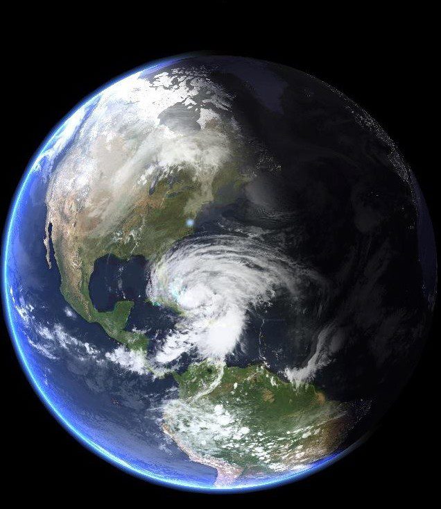
Hurricane Sandy Earth from Space 2

Hurricane Sandy over Abaco from the International Space Station

I  have been surprised at the response the map generated by way of ‘Likes’ and comments expressing relief… So from my current safe distance of precisely 4250.00 miles from Marsh Harbour, I am posting an update with helpful maps and a bit of general hurricane info. The agencies all agree that Gonzalo will hook east as it progresses northwards. The Bahamas outlook is promising, though for example Bermuda looks to be at risk.  There’s more on hurricanes on the page ABACO WEATHER. I always think that Wunderground produce the clearest maps for general purposes, though there’s a great deal more information to be had from the NOAA site, to which there’s a direct link in the Sidebar (I’ve moved it to near the top for the time being).

CURRENT TRACKING FORECASTS OCT 14 2014 

WUNDERGROUND 3-DAY TRACKING & WIND MAP at201408at201408_satat201408_radar

NOAA TRACKERS & FORECASTS

085519203828W_NL_sm

ACCUWEATHER SATELLITE VIEW & TRACKERHurricane Gonzalo Tracking Map  - clip jpg

THE SAFFIR-SIMPSON SCALE

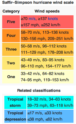
Here is a reminder of how tropical storms and hurricanes are measured for intensity, as decreed by the S-SS, followed by the National Hurricane Center’s explanation of the gradations of relative intensities.

Saffir-Simpson Scale (Wiki) jpgT

The Saffir-Simpson Hurricane Wind Scale is a 1 to 5 rating based on a hurricane’s sustained wind speed. This scale estimates potential property damage. Hurricanes reaching Category 3 and higher are considered major hurricanes because of their potential for significant loss of life and damage. Category 1 and 2 storms are still dangerous, however, and require preventative measures. In the western North Pacific, the term “super typhoon” is used for tropical cyclones with sustained winds exceeding 150 mph.

Category   Sustained Winds Types of Damage Due to Hurricane Winds
1 74-95 mph
64-82 kt
119-153 km/h
Very dangerous winds will produce some damage: Well-constructed frame homes could have damage to roof, shingles, vinyl siding and gutters. Large branches of trees will snap and shallowly rooted trees may be toppled. Extensive damage to power lines and poles likely will result in power outages that could last a few to several days.
2 96-110 mph
83-95 kt
154-177 km/h
Extremely dangerous winds will cause extensive damage:Well-constructed frame homes could sustain major roof and siding damage. Many shallowly rooted trees will be snapped or uprooted and block numerous roads. Near-total power loss is expected with outages that could last from several days to weeks.
3
(major)
111-129 mph
96-112 kt
178-208 km/h
Devastating damage will occur: Well-built framed homes may incur major damage or removal of roof decking and gable ends. Many trees will be snapped or uprooted, blocking numerous roads. Electricity and water will be unavailable for several days to weeks after the storm passes.
4
(major)
130-156 mph
113-136 kt
209-251 km/h
Catastrophic damage will occur: Well-built framed homes can sustain severe damage with loss of most of the roof structure and/or some exterior walls. Most trees will be snapped or uprooted and power poles downed. Fallen trees and power poles will isolate residential areas. Power outages will last weeks to possibly months. Most of the area will be uninhabitable for weeks or months.
5
(major)
157 mph or higher
137 kt or higher
252 km/h or higher
Catastrophic damage will occur: A high percentage of framed homes will be destroyed, with total roof failure and wall collapse. Fallen trees and power poles will isolate residential areas. Power outages will last for weeks to possibly months. Most of the area will be uninhabitable for weeks or months.

HOW DO HURRICANES GET THEIR NAMES?

Check out the page ABACO WEATHER

BACKTRACKING

Hurricane Irene 2011 Bahamas Map Accu jpg Hurricane Sandy Map Bahamas 2012 jpg

HOLE-IN-THE-WALL, ABACO: THE ‘HOLE’ THAT’S NO LONGER A WHOLE


DCB GBG Cover Logo curly

HOLE-IN-THE-WALL, ABACO: THE ‘HOLE’ THAT’S NO LONGER A WHOLE

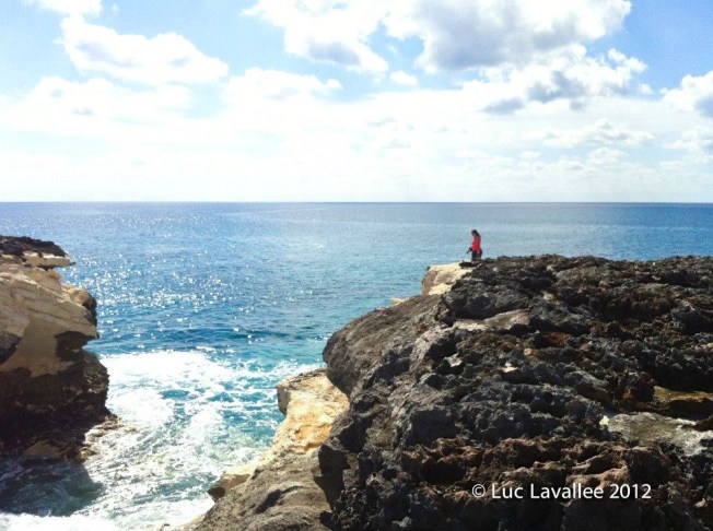
I recently posted 3 items from different perspectives about Hole-in-the-Wall, the destruction of its “roof” by Hurricane Sandy, and the consequent creation of a small islet (provisional names suggested include ‘Holey Isle’ & ‘Sandy Isle’). I also showed what were apparently the last images of the Hole with its roof on (Jack Bowers); and the first of the new post-Sandy geology taken on November 6th (John Haestad) CLICK HERE. It now transpires that some excellent photos were in fact taken a the previous day, November 5th, when Tara Lavalle and her family went to HitW for an outing and to investigate the reports about the Hole. So the pictures below taken by Tara and Luc (to whom many thanks for use permission) now stand as the first post-Sandy images of the ‘Gap’. Unless anyone knows better…

The lighthouse and outbuildings looking back from the Hole-in-the-Wall routeHOLE-IN-THE-WALL LIGHTHOUSE ABACO post Sandy

OMG! Surveying the new scenery           HOLE-IN-THE-WALL ABACO post Sandy 2

The  water still boils through as before…HOLE-IN-THE-WALL ABACO post Sandy 1

The northern end of the new islet, showing the bright new rock-face. Beyond, Nassau… HOLE-IN-THE-WALL ABACO post Sandy 3

ABACO: WHALES, DOLPHINS & MANATEES – BMMRO POST-SANDY REPORT


HURRICANE SANDY – AND AFTER

A report by Kendria Ferguson on the impact of Hurricanes Sandy for the BMMRO

After all the exciting but unexpected events of October, slowly life is returning to normal. As the whimsical but intimidating winds of Hurricane Sandy encompassed the research center, we felt a few limited blockbuster hits. Without power for four days and no contact with the world outside of Sandy Point, we felt like we were in a twilight zone! Hurricane force winds crept up on Abaco during the wee hours on Thursday, October 25th; predicted to be a Category 1, Hurricane Sandy surely made her presence felt! Luckily, we only had a few minor leaks at the research center but the community of Sandy Point and other parts of Abaco had severe flooding and extensive damage. 

Trapped in a house for four days with a hurricane that refused to leave, our concern for Georgie (the Christopher Columbus of our Bahamian manatees) began to grow. Georgie recently separated from her mother (Rita) in June of this year, and shortly thereafter decided to take a detour to Abaco, over 70 miles from the Berry Islands, Northern Bahamas, where she previously resided with a small population of manatees. Having travelled a tremendous distance around Abaco, she finally settled in at a small community called Cherokee Sound, located on the eastern side of Abaco. During Hurricane Irene, October 2011, Georgie and her mother swam from Spanish Wells, Eleuthera to Nassau. Whether this shift in locations was entirely due to the passing of a hurricane is unknown but scientists feared that Georgie could possibly get confused during the storm and take off to an unknown location.

Last sighted on the 24th of October, Georgie wasn’t seen again until November 4th, almost a week after Sandy had passed the community of Cherokee. She returned with a back covered in moss, an outstandingly healthy looking figure and thankfully no visible injuries/wounds as a result of the storm (these photos were taken on November 5th).

After hurricanes, an increase in shark bites has been documented amongst the dolphin population that inhabit the Little Bahama Bank (Fearnbach et al. 2012). Scientists believe that hurricanes may be the driving force for the relocation of dolphins to waters deeper than their preferred habitat which therefore makes them more accessible to predators such as oceanic sharks. Increase in wave height, storm surge, sediment erosion and deposition can make these once tranquil shallow habitats confusing for dolphins and manatees to navigate.

Photograph of a juvenile dolphin with a fresh and severe shark-bite wound on its flank

In the 1980’s and 1990’s, a decline in adult survival rate after the passing of major hurricanes (Category 3 and higher) among manatee populations in Florida were attributed to possible injury from debris, strandings and displacement of animals as a result of habitat loss and strong water currents (Langtimm et al. 2003).

As we hoped, Georgie appeared to have tucked herself into the nearby mangroves and returned within eyesight when she felt it was safe enough to leave the shelter she sought out during hurricane Sandy. Now that the storm has passed, falling debris has been cleared and our shallow water habitats have returned to the calm and often crystal clear waters we remembered them to be. We can all now let out a huge sigh of relief! We all survived Super-Storm-Sandy!

Fearnbach, H. D. (2012). Seasonality of calving and predation risk in bottlenose dolphins on Little Bahama Bank. . Marine Mammal Science, 28(2), 402-411. 
Langtimm, C. A. (2003). Lower survival probabilities for adult Florida manatees in years with intense coastal storms. Ecological Applications, 13:257-268.

Story by Kedria Ferguson, BMMRO’s education officer and manatee expert

The End

GEORGIE THE ABACO MANATEE: IS SHE RELATED TO AN ELEPHANT?


GEORGIE THE ABACO MANATEE: IS SHE RELATED TO AN ELEPHANT?

Georgie, having returned to Cherokee after Hurricane Sandy, is still around there and seems to have made it her home. While she was missing, it was thought she had headed off instinctively for the protection of the mangroves. However a number of sighting reports made since Sandy suggest that she had sensibly swum up the canal at Casuarina, where she was able to keep her head down until the storm had safely cleared northwards, and she was able to return to base. Because she had shed her tag, we’ll never know the full story… 

Georgie safely back at Cherokee after Hurricane Sandy

Recently an interesting article by BEACH CHAIR SCIENTIST considered the relationship between sirenians and pachyderms, and added some handy comparative facts (you can seen more manatee facts on this blog HERE). Thanks, BCS, for use permission (the relevant credits are contained in the article).

Are manatees and elephants related?

by Beach Chair Scientist

It might be very difficult to imagine, but manatees (also known as ‘sea cows’) share a common ancestor with elephants which might come as a surprise if you thought manatees shared a common ancestor with other marine mammals such as dolphins, whales, or sea lions. Here are 10 facts that link manatees and elephants are long-lost relatives.

1. Scientifically, manatees and elephants are classified as subungulates. Other mammals in the Subungulata superorder are hyraxes and aardvarks.
2.Manatees and elephants have an uncommon-shaped heart that is spherical. To compare, most mammals have a single-pointed tip at the base (i.e., “heart”—shaped).
3. The West Indian and West African manatee have three or four fingernail-like structures on the tip of their flippers, just like that of the toenails on the feet of elephants.
4. Manatees and elephants both have a thick, gray skin with very sparse hair.
5. Manatees and elephants have molars which move toward the front of the mouth, eventually break off, and are restored by those at the rear. Elephants have a limited number while manatees are never-ending.
6. Manatees have two incisors that bear a resemblance to elephant tusks.
7. Manatees use their large, flexible muscular lips to break apart vegetation in the water and skillfully steer food to their mouths. This is very similar to the action of the elephant eating with his trunk.
8. Manatees and elephants are herbivores. Manatees tend to feast on sea grass and freshwater plants and consume up to 100-150 pounds a day. Elephants tend to feast on small plants, bushes, fruit, twigs, tree bark, and roots and consume up to 330-375 pounds a day.
9. Male manatees and elephants are known as bulls. Female manatee and elephants are known as cows. Young manatee and elephants are known as calves.
10. Manatees and elephants are both endangered. Their numbers have dropped due in a large part to human activities.

Manatee image (c) cruisenaplesflorida.com, elephant image (c) gallery.hd.org

Here is a fantastic TEACHING RESOURCE from the University of Florida and Se Grant extension I uncovered while pulling this post together.

Credit: SavetheManatee.org

To whom thanks also for this: WHAT DO MANATEES SOUND LIKE? 

[audio http://www.savethemanatee.org/Manatee%20Sounds/Track03mp3.mp3]


HOLE-IN-THE WALL ABACO: “MIND THE GAP” – A NEW ISLET IS BORN


HOLE-IN-THE WALL ABACO: “MIND THE GAP” – A NEW ISLET IS BORN

17th October 2012

Jack Bowers and friends visited Hole-in-the-Wall and took what are probably the last photos of Hole-in-the-Wall before Hurricane Sandy struck, and the central arch was smashed into the sea – this one below, and others HERE

6th November 2012

Less than 3 weeks later, John Haestad made the same trip towards the end of the promontory. This time, it was different. The arch was gone. Beyond the breach, a new islet, separated from the mainland by a foaming channel. John has kindly given use permission, and you are now looking at what may be the first image of Abaco’s new geography. A feature that had appeared on maps since at least the early c18, been a landmark for marine navigation for centuries, and lent its name to the lighthouse station, has gone forever. A very small island at the southeastern tip of Abaco has been born…

HOLE-IN-THE-WALL PROMONTORY, ABACO
(Since posting this, Jack Bowers has come up with ‘Holy Isle’, which has a certain ring to it…)

ADDITION I have now found a photo by Jennifer Arrington (to whom thanks for use permission) which shows from a helpful angle both the intact Hole and the small tip of land beyond, now an island. Many photographers are understandably drawn to the Hole itself by the time they have trekked across the sharp uneven rocks to get to it. This is one of the few I have found that gives a wider perspective.

HOLE-IN-THE-WALL: THE ‘ISLAND’ BEFORE IT BECAME ONE…

AFTERWORD FROM ROLLING HARBOUR

For an interesting philosophical and metaphysical discussion on whether the collapse of the arch made any sound if there was no one (and / or no living creature) there to hear it, check out IF A TREE FALLS IN A FOREST… but please don’t if that sort of arcane  and /or pointless argument drives you mad with irritation 

ABACO’S ‘HOLE-IN-THE-WALL’ BEFORE SANDY DEMOLITION: FIRST & LAST EVER IMAGES


ABACO’S HOLE-IN-THE-WALL BEFORE HURRICANE SANDY DESTRUCTION

THE FIRST & LAST EVER IMAGES OF A GEOGRAPHICAL LANDMARK

This post follows on directly from my PREVIOUS POST about Hurricane Sandy’s destruction of Abaco’s Hole-in-the -Wall rock ‘bridge’. Thanks to Abaco resident Jack Bowers, his camera and his kind permission, I am able to show what are almost certainly the very first and the very last pictures of Abaco’s Hole in the Wall aka ‘Hole in the Rock’, the landmark rock formation at the southeastern tip of the island.

THE EARLIEST KNOWN PICTURE OF HOLE-IN-THE-WALL

The earliest picture that I have been able to trace is a fine nautical aquatint dated 1803 by J.Wells based on a shipman’s sketch. There’s more detail about it in the previous post, but for the full details of this picture, its origin, and a very early description of  one of Abaco’s best-known features CLICK HOLE-IN-THE-WALL AQUATINT 

THE LAST PICTURES EVER TAKEN OF THE HOLE IN THE WALL, ABACO

Jack Bowers and some friends visited Hole-in-the-Wall a week before Hurricane Sandy swept in from the south. He writes “I hiked all around (and foolishly IN) the Hole on 10/17/12, a week before its demise. I may have the last photos taken of various aspects of it, if needed. I noticed some serious cracks (mostly on the proximal side of the arch) and placed my feet carefully away from them, but the collapse did not seem this imminent. I also shot some nice shots of the lighthouse from the distal point of the rocks (a shot not easily obtainable now). Trying to find a positive, the new “Window” should provide some spectacular new splashes that the arch used to largely contain”. Please note that the very fine photos below are all ©Jack Bowers

The ‘Land’s End’ promontory of Abaco, taken from the lighthouse station. The Hole is (was) near the tip.

Looking back to the lighthouse on the hike south

Rough seas ahead…  foreshadowing the later rock destruction                

A last view of ‘Hole in the Wall’ as it used to look….     

The dramatic view from below the arch – it will never be seen like this again…

ABACO’S CHANGED GEOGRAPHY AS FROM 10.24.12 FOR ALL ETERNITY

HOLE-IN-THE-WALL: LATE PLEISTOCENE EPOCH to LATE OCTOBER 2012

Very soon after these photos were taken, the history of the Hole and the geography of Abaco abruptly changed. The weather worsened, Tropical Storm Sandy gathered strength north of Cuba to reach hurricane force, and a week later the rock arch had been simply smashed into the boiling sea by the combined power of wind and the water. It seems unlikely that in the intervening week, with a major storm approaching, anyone else will have made the long rough drive 15 miles along the track to the lighthouse, traversed the difficult terrain of the promontory, risked the increasing winds and swelling seas, and calmly toted a camera at the underside of the arch. So unless and until I hear otherwise, I shall consider Jack’s pictures to be the final record of an Abaco landmark known to sailors for many centuries, mapped by name since 1738 (or earlier), first depicted in 1803 and probably in existence since the last ice-age. R.I.P. (Rest in Pieces)

AFTERWORD: DOES THIS SORT OF THING HAPPEN OFTEN ON ABACO?

Yes. As elsewhere in the Bahamas or indeed any hurricane zone. Here’s an example from last year demonstrating the power of Hurricane Irene, which also scored a direct hit on Abaco. The top photo is a shot of the Delphi Club beach at Rolling Harbour looking south, taken by me in early 2011. I have cropped it to enlarge the view of the large rock in the sea beyond the small bay on the middle left. It’s a substantial, solid, slab visible at all tides.

Hurricane Irene passed directly overhead on August 26 / 27 2011. Here’s my photo taken this year, showing the rock with the centre blasted out during the storm. Impressive damage! (That little piece of foreshore needs a clean-up… most of that stuff looks like plastic junk / nylon rope etc, the sort of detritus that takes a mere century or three to degrade…)

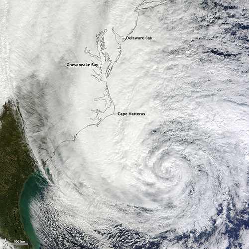
HURRICANE SANDY: VIEWS FROM SPACE, STORM SURGES & THE THREAT TO NEW YORK…


INTERACTIVE HURRICANE SANDY STORM TRACKER

Type in your location for current path prediction

Click Pic!

<<<<<<<<<<<<<<<<>>>>>>>>>>>>>>>>>>

1. SCARY BEAUTY

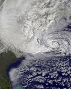
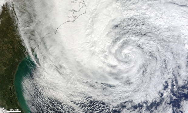
HURRICANE SANDY: VIEWS FROM SPACE

LATEST NASA-GOES IMAGE 29 OCTOBER


Photo credits NASA-GOES, NOAA, BBC & honourable tips of the hat to sundry Sandy magpies

2. STORM SURGE

HURRICANE SANDY’S THREAT TO NEW YORK

US EAST COAST FLOOD PROJECTION MAP

“12 FEET” The biggest fear from this storm in the New York City area is the storm surge. Right now anything from 6 to 12 feet seems quite possible. The greatest storm surge in modern history at Battery Park was 10.5 feet in 1960. Irene’s storm surge was a little over four feet in New York. That’s why you’re seeing evacuations in New York (extract, Guardian UK)

sandy storm surge

Photo credit: Noaa.gov

FOR 9 MORE REASONS THAT MAKE SANDY AN EXCEPTIONAL STORM, CLICK HERE

HURRICANE SANDY AFTERMATH: ABACO PICTURES, NEWS FROM DELPHI CLUB, BAHAMAS & MANATEE UPDATE


DAMAGE FROM HURRICANE SANDY AT THE DELPHI CLUB, ABACO

The storm has passed from the Bahamas and the clear-up is underway – but further north communities are bracing themselves for the onslaught. The news today  from contacts, from Facebook and the web generally, is of thankfully little lasting damage, with power and comms restored in many places. There’s been plenty of flooding – eg Sandy Point – and tree / plant mayhem.

The Delphi Club was again, as with Irene last year, almost directly beneath the eye of the storm. Then, a couple of leaves were lost from the pineapple crown (above), a few fittings were smashed, and the gardens were unceremoniously rearranged. Peter Mantle, Delphi Club supremo, has posted his record of the last few days at the club – the approach of Sandy, the storm, and the aftermath. I am posting extracts below, to be read (chronologically) from the bottom entry to the top of the page. For those who haven’t experienced a storm of this violence, Peter’s account gives a vivid picture of the before, the during and the after…

Apologies for having posted about Sandy in detail with maps etc, and at the crucial time tailing off  while I was away and had only an iPhone™  and a sporadic connection…

STOP PRESS: AMERICAN OYSTERCATCHERS – BRAVE OR FOOLISH? 29 October

Peter Mantle has just sent me a ‘Sandy’ photo from the Delphi Club beach, showing a group of oystercatchers on the rocks at one end of Rolling Harbour. Storm detritus already festoons the rocks. Have the birds seen what’s about to hit them? Are they waterproof? 

STOP PRESS: BMMRO MANATEE UPDATE 29 October

The BMMRO has posted news from Sandy Point and for those who have been asking after manatee Georgie’s welfare, an update:

“Hi Everyone, everything is ok here at the research center! We are working on getting information on Georgie’s whereabouts and we will happily update everyone as soon as we hear anything. There’s still a bit of damage here in Abaco that is preventing travel but hopefully we will be able to get up to Georgie soon”.

STOP PRESS: SOME ABACO IMAGES 28 October

(credits to Timothy Roberts & Cindy James Pinder and their facebook posts)

SANDY TAKES BONEFISH; DARK HUMOUR ON DARK DAYS

OCTOBER 27th Among the many bits of minor damage caused by Hurricane Sandy was the destruction of our bonefish weather vane. This had been hand-made by the other Sandy, our general manager, and stood atop his lodgings. Snapped off, the copper creation was found nearby, bruised and dented, rather like ourselves.

Yet again, we have been very fortunate – staff and guests are all well. And most of the damage caused by the 100mph winds was minor. The storm had its moments, but the worst bits were at nighttime when many people were huddled safe in bed. Lots of bumps and bangs provided a spooky soundtrack, but it was more of a B movie than a full-blown Hollywood epic. That said, I hate to think what a really big Category 3, 4 or 5 hurricane would be like.

We still have no mains electricity; thank God for the gennie. We have no phones or mobile connection, so we have little idea of what is going on elsewhere on the island. We hope for the best but fear not all will have escaped as lightly as we did. Some of the staff from Crossing Rocks are stranded here by flooding. But the wireless internet is back so all will soon be revealed.

Yet again, the gardens have been shredded. The banana trees have been snapped off mid-fruiting. My favorite banyan tree has broken in half again, having nearly bounced back from Irene. The big Bismark ferns are banjaxed, the bougainvillea is blasted leafless and the pool is a mess. But who cares. We are fine. Dunkirk spirit? Well, very black humour and spirits of a different kind have seen us through.

“I survived Sandy” T-shirts are now in preparation, but that’s a staff joke about their hyperactive and heroic boss…..

A BAD HAIR DAY…

OCTOBER 25th It is getting distinctly breezy here, with winds as bad as any Irish gale. But Hurricane Sandy, now upgraded to a Category 2 hurricane, is still some 18 hours away and currently features average winds of 105mph with higher gusts. It may get even worse, they say. So no fishing today. More guests have made it in. Bahamasair even ran a plane out of Nassau at first light this morning.

While we still have power and phones, the lines are buzzing and we are glued to the internet. It seems odd to see that Sandy is the lead news story on the BBC. Non-technical guests have adjourned to the library (where “A Perfect Storm” and “Winnie the Poo and the Blustery Day” are current favourites). The air of gloom is more attributable to the fact that Arsenal lost at home last night than to any fears for personal safety.

We may go quiet for a while.

NOTHING VERY FEMININE ABOUT THIS SANDY

OCTOBER 24th, noon Tropical storms are now given boys’ and girls’ names alternately; in the old days they were all girls. The one that currently threatens us is Sandy, a name that is more commonly applied to females in this part of the world. But there is nothing too feminine about this storm; as the forecast deteriorates and Sandy intensifies into a hurricane over Jamaica, we are becoming more and more concerned by its macho capabilities.

The National Hurricane Centre now predicts that Sandy will pass very close to Abaco – the predicted path having shifted overnight. As it now looks, the eye may pass just 25 miles from us, which would basically be a direct hit since damaging winds spread far out from the centre. We are going to have to keep a very close on on this little girl over the next 48 hours.

ALL EYES ON SANDY

OCTOBER 23rd No sooner has the Club reopened for the new season than a tropical storm appears on the horizon. And, in a twist of divine humour, it’s been christened after our general manager, Sandy.

Sandy (the mostly human version) is tracking Sandy (the swirling tempest) on an hourly basis. As it now stands, we are in the “cone” of the likely track of the storm over coming days. Currently south of Jamaica, TS Sandy is turning north and could yet morph into a hurricane. It’s expected to be over or near us by Friday night, with “average” winds of nearly 60mph and gusts of up to 90mph.

Hatches will therefore be battened, outdoor furniture put back indoors and supplies of grog reinforced. The lucky fishers in residence will have to take a breather, while the new chef, John, will receive a special form of baptism.

Tropical storms this late in the year are a great rarity. Somehow that is not very reassuring just now. But the forecast for the following week is rather better… 

Click image to visit the Delphi Club