KEY WEST QUAIL-DOVES ON ELBOW CAY, ABACO


Key West Quail-Dove, Elbow Cay, Abaco (Milton Harris) 1a

KEY WEST QUAIL-DOVES ON ELBOW CAY, ABACO

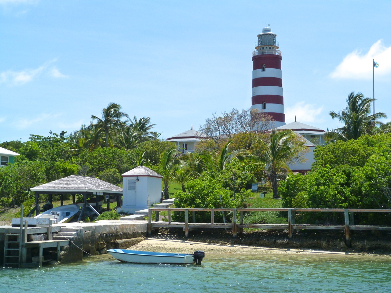
Elbow Cay has many reasons to be admired: the historic iconic striped lighthouse, Hope Town’s pretty harbour and surroundings, wonderful beaches, some great places to eat and stay, no cars, the general impression of being a happy and most congenial place to be. To which, may I add, a good place for birding in general and for pinning down a couple of hard-to-find species in particular. Resident and birder Milton Harris has sent me a few photos from his recent outings. There is at least one burrowing owl at the north end of Elbow Cay. These owls are reputedly very rare vagrants on Abaco but recent sightings suggest numbers may be increasing. More of which another time.

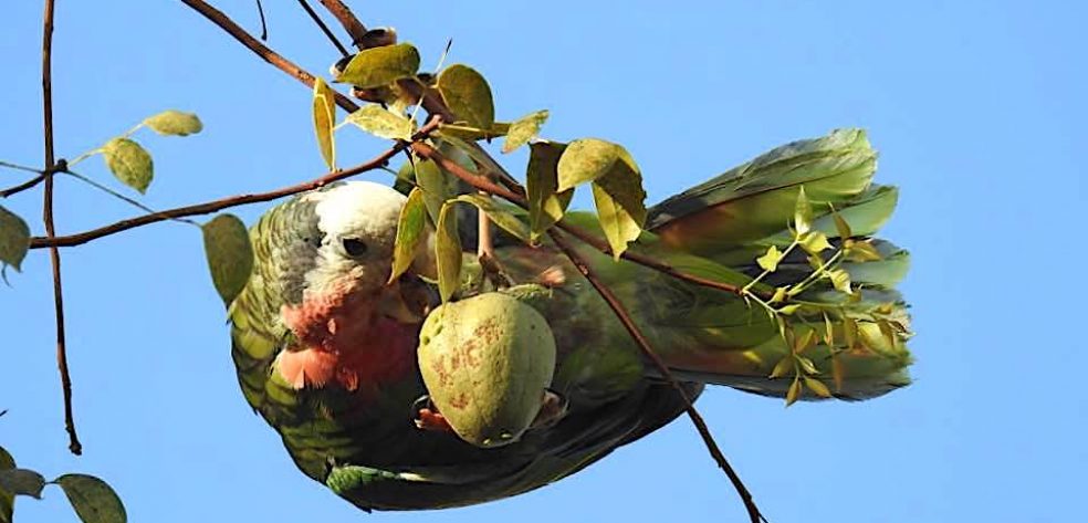
The Key West Quail-Dove Geotrygon chrysia is a permanent breeding resident on Abaco, but relatively uncommon. These birds are difficult to find, flighty, and fly fast. They are hard to get a clear photo shot at, and reluctant to pose attractively in the open in good light while keeping still. Sadly, we never got a good clear shot of one to use for THE BIRDS OF ABACO‘. A great one from Nassau, yes, but disqualified from inclusion by location. 

Key West Quail-Dove, Elbow Cay, Abaco (Milton Harris) 6a

Milton says he has been seeing KWQBs “at the north end of Elbow Cay off and on for the past year. Normally they flush and fly though the trees at great speed, so I have not been able to get a photo.  Today I was creeping through the coppice and one walked out in a clear spot and posed!” 

Approximate KWQD location
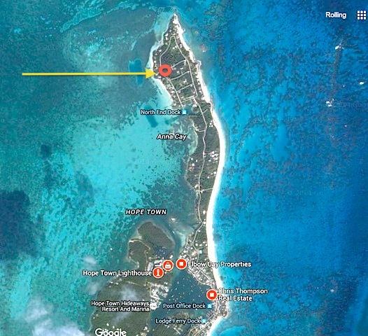
Elbow Cay (north) map jpg

WHAT’S IN A NAME?

Disappointingly little these days. The KWQD originally bred in the Florida Keys and was actually discovered on Key West (incidentally a James Bond location used in ‘Licence to Kill’). Sadly the species no longer breeds in Florida (reasons unknown – all shot, maybe?) and these doves are now found only as vagrants there. I have checked the Bahamas National Trust’s very helpful BNT HUNTERS GUIDE – in the Bahamas, the quail-dove is completely protected and may not be shot or taken at any time [but I have a sneaking suspicion that they would be delicious…]

Elbow Cay: Abaco’s KWQD hotspot (eBird)KWQD hotspot map abaco

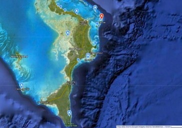
SO SHOULD IT BE RENAMED THE ELBOW CAY QUAIL-DOVE?

A nice idea, Elbow Cay being the sole Abaco hotspot for the species over the last 10 years, as recorded on eBird. But in fact the birds are found throughout much of the Caribbean so there will be other contenders for the honour. Probably best left as it is to avoid contention.

Key West Quail-Dove, Elbow Cay, Abaco (Milton Harris) 5a

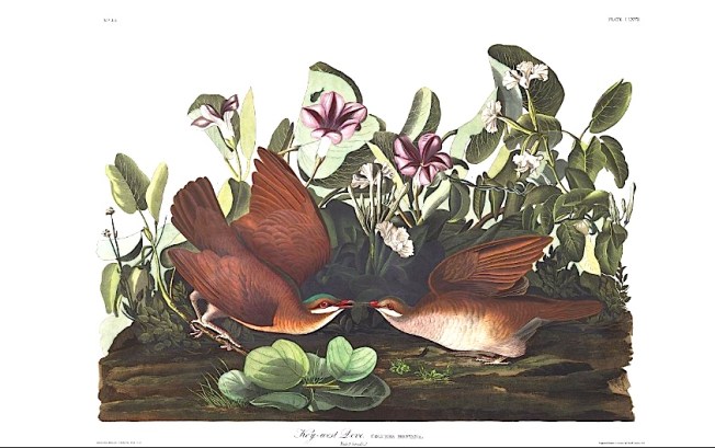
I always enjoy comparing the ‘real thing’ as you might see a bird in the coppice near you, with the depictions of the bird made by one of the pioneers, Audubon prime among them. Here’s his very charming take on the species. But I agree, it’s not very like the bird you are looking out for…

Key-west Dove (J J Audubon)

Credits: many thanks to Milton Harris for his excellent photos of this tricky bird; hotspot clip from eBird

ELBOW REEF LIGHTHOUSE, ABACO: THE OLD LADY’S BIG DAY


Hope Town Lighthouse, Elbow Cay, Abaco

ELBOW REEF LIGHTHOUSE, ABACO: THE OLD LADY’S BIG DAY

There are various overwrought ‘describing’ words that have become devalued and tired through overuse. Unique. Unsurpassed. Unparalleled. Iconic. However the famous and much-loved Elbow Cay Lighthouse could plausibly lay claim to any one of those adjectives. Let’s make that ‘all’. Earlier this year, following a meticulous survey, repairs and refurbishments were made to this stately 89 foot high, 101 step light that came into operation in 1863 during the height of the American Civil War. 

You can read more about the lighthouse, its importance and its machinery in various earlier posts (use the search box), and there is other material including details of the recent repair program HERE. This post is simply to advertise the forthcoming 2nd Lighthouse Festival that takes place in Tuesday June 23rd. The flyer below tells you all you need to know about the day.

11165251_902234616503783_3983866159670923203_n

For this event, the students of Hope Town Primary School, in conjunction with the invaluable ELBOW REEF LIGHTHOUSE SOCIETY , have produced a wonderful book celebrating the lighthouse, with proceeds of sale benefitting the school’s volunteer programs and the Society’s ongoing projects. I am sure will be a best seller – make it happen!

10986656_10153399883840815_3126863414253161396_n11140378_10153399883870815_873890178916274603_n

As last year, the events will include an auction. Among the wide variety of items to be auctioned will be a 15″ x 15″ print on canvas of my photo of a Western Spindalis, taken on the drive of the Delphi Club and included in “THE BIRDS OF ABACO” (a copy of which was auctioned last year). 

Western Spindalis, Abaco (Keith Salvesen)

Maybe a few more pics of such an interesting building are called for…. And a reminder of some key words to scatter liberally into your conversation at the event. Or anywhere, really: “Fresnel Lenses”, “Mercury Bed”, “Clockwork Mechanism”, “Trinity House, London”.Hope Town Lighthouse, Elbow Cay Abaco

Hope Town Lighthouse, Elbow Cay, Abaco (Lamp, Fresnel Lens) hoplit22 Hope Town Lighthouse, Elbow Cay, Abaco hoplit20 Hope Town Lighthouse, Elbow Cay, Abaco hoplit19 Hope Town Lighthouse, Elbow Cay, Abaco hoplit18 Hope Town Lighthouse, Elbow Cay, Abaco hoplit17 Hope Town Lighthouse, Elbow Cay, Abaco (Fresnel Lens) hoplit6 Hope Town Lighthouse, Elbow Cay, Abaco hoplit4 Hope Town Lighthouse, Elbow Cay, Abaco hoplit2 Hope Town Lighthouse, Elbow Cay, Abaco hoplit3

And finally a wonderful photo of Hope Town centred on the Lighthouse complex. Enjoy June 23rd.Elbow Reef Lighthouse Society

Logo of the World Lighthouse Society

Logo of the World Lighthouse Society

Credits: Lighthouse exteriors and Spindalis RH; all interiors Mrs RH; props to Elbow Reef Lighthouse Society (and ?David Rees for the aerial view…); Annie Potts for her inspiring book “Last Lights” about the intriguing lighthouses of the Bahamas

HOPE TOWN, ABACO: DOLPHINS & A LIGHTHOUSE IN THE SUN


Hope Town, Elbow Cay, Abaco 13

HOPE TOWN, ABACO: DOLPHINS & A LIGHTHOUSE IN THE SUN

A trip to Hope Town and Elbow Cay is a always a treat. Especially if it includes lunch with friends. Most of my previous visits have been in cloud or rain, so the glory of the historic and indeed iconic candy-striped lighthouse has been rather marred. I left Delphi in hot sunshine, but it began to cloud over ominously during the half-hour drive north to Marsh Harbour and Albury’s Ferry Terminal. I was still optimistic when I arrived, though…Hope Town, Elbow Cay, Abaco 2…until I looked the other way. The 20-minute crossing of the Sea of Abaco to Elbow Cay was characterised by a sudden pelting rain storm and a churning sea. A passenger lay down greenly, and I began to count the minutes.Hope Town, Elbow Cay, Abaco 1However, as we approached Hope Town we emerged from the gloom into bright sun, and a fine view of the lighthouse. This edifice has one of the last remaining kerosene-lit lights in the world, attended to every 2 hours throughout the night by volunteers. The mechanism sits on a bed of mercury, and the light shines through the original fresnel lenses. Much of the original british-made machinery is still in place. For a tour round the interior, with excellent photos taken by Mrs RH, and views from the top platform, click HOPE TOWN LIGHTHOUSE Hope Town, Elbow Cay, Abaco 3 Hope Town, Elbow Cay, Abaco 4Lunch at the pleasant Harbour’s Edge Restaurant was enhanced by two – or was it three? – bottlenose dolphins that swam around the harbour. I was torn between eating, chatting  and photographing them. I didn’t catch the wonderful lazy arcs they made as the broke the surface and slowly arched back into the water. It was near impossible to predict where they would surface next. Here are a couple of less dramatic shots… Hope Town, Elbow Cay, Abaco 11Hope Town, Elbow Cay, Abaco 5After lunch there was time for a quick wander round the attractive little town, with its pastel-coloured houses. Hope Town 1a

There was a YELLOW ELDER tree in bloom, the national flower of the Bahamas. [Later: as it turns out, I was caught in the act… of photography]Hope Town, Elbow Cay, Abaco 7Hope Town, Elbow Cay, Abaco 6996860_10200325236513792_581389694_n

Hummingbird Cottage Art Centre and Gallery

I was taken to see the new HUMMINGBIRD COTTAGE ART CENTRE & GALLERY  a fine work of building restoration in the centre of town that provides a surprisingly large exhibition space and an idyllic place for art classes and related activities.

DSC_0076-150x150Hope Town, Elbow Cay, Abaco 10Hope Town, Elbow Cay, Abaco 8Hope Town, Elbow Cay, Abaco 9Later, I took the ferry back to Marsh Harbour, taking a final good look at the lighthouse, still thankfully in full sunlight against a vivid blue sky.Hope Town, Elbow Cay, Abaco 12Hope Town, Elbow Cay, Abaco 15  Hope Town, Elbow Cay, Abaco 14Hope Town, Elbow Cay, Abaco 16

LINKS

HOPE TOWN LIGHTHOUSE: THE WORKS

YELLOW ELDER: BAHAMAS NATIONAL FLOWER

Screen-Shot-2013-01-30-at-8.33.11-PM

ALBURY’S FERRY SERVICE

and for a comprehensive overview of Hope Town and Elbow Cay

hopetown

OLYMPUS DIGITAL CAMERA

Hummingbird Cottage ©Brigitte Bowyer

HUMPBACK WHALES IN THE BAHAMAS: TWO SIGHTINGS & AN ENTANGLEMENT


HUMPBACK WHALES – BMMRO REPORT JANUARY 2012

The BMMRO has posted recent whale news on its site – an entanglement off Elbow Cay with a happy ending, a sighting off Long Island in January, and another in February with images    (CLICK LOGO for BMMRO website)

1. An Entanglement 30.12.11  During the winter months the Bahamas occasionally get a sighting of a humpback whale migrating northward. For some reason a few of the migrating whales take a route a little closer to our islands and allow us the wonderful experience of seeing them.

On the 30th December 2011 Joseph Strickland and his crew who had been staying on the Highlander in Hope Town harbour, came across an entangled humpback whale. Due to the courage and calm response of Joe and his team, they managed to release the 40′ humpback. The whale had been entangled in a thick rope of approximately 600′ in length attached to a fishtrap. The animal was found off  Sea Spray marina in 40 feet of water off Elbow Cay, Abaco. They managed to free the animal of the fishpot which it had been dragging… as well as freeing the animal of the majority of rope, with only 20′ of line remaining on the whale. We would sincerely like to thank Mr & Mrs Strickland and their family for their extrodinary effort to free this animal, and also to report the encounter in detail.

Unfortunately as humpbacks are one of the more coastal whales, they often end up entangled in fishing gear, and come into contact with fishing pots, as well as being susceptible to vessel strikes. However, this species have made a remarkable recovery since the whaling era and in the North Atlantic abundance estimates are now approximately 12,000 humpback whales.

2. A sighting on 14.01.12  A better start to the New Year provided us with a single humpback sighting on Saturday 14th January off of Cape Santa Maria, Long Island. 

3. A sighting on 8.02.12 Finally, on Wednesday 8th February, a mother-calf humpback pair were spotted off of Dutch Bar, Spanish Wells, providing us with these beautiful pictures! Report and Image Credits BMMRO 2012


HOPE TOWN ANNUAL HERITAGE DAY SAT 3 MARCH 2012


HOPE TOWN ANNUAL HERITAGE DAY

SAT 3 MARCH 2012    

BE  THERE!

BMMRO WHALE, DOLPHIN & MANATEE SIGHTINGS / WINTER REPORT


BMMRO WHALE, DOLPHIN & MANATEE SIGHTINGS AND WINTER REPORT DECEMBER 2011

This was an interesting month. For a start, a humpback whale was reported off Elbow Cay, and a sperm whale further out to sea to the east. There were several cetacean reports between Sandy Point and Hole-in-the-Wall. Perhaps best of all, West Indian manatees – mother and calf – were reported in the area at the end of December, just off the Berry Islands – photo below, and further details in the BMMRO Winter Newsletter via the blue link.

THE WINTER NEWSLETTER contains much of cetacean interest, as always. It features articles on the effects of climate change of the declining Sea of Abaco bottlenose dolphin population; manatees in the Bahamas; ‘Life after Death’ – the importance of whale carcasses on the deep sea eco-system; sonic body-length measurement of sperm whales; the false killer whale stranding on Guana Cay (see POST); educational news update; and much more besides

BMMRO NEWSLETTER WINTER 2011/12

Courtesy of NAHRVALUR and her excellent wildlife blog, here is a cute view of a manatee in a Florida Reserve, where a webcam has been installed 

Manatees (family Trichechidae, genus Trichechus) are large, fully aquatic, mostly herbivorous marine mammals sometimes known as sea cows. There are three accepted living species of Trichechidae, representing three of the four living species in the order Sirenia: the Amazonian manatee (Trichechus inunguis), the West Indian manatee (Trichechus manatus), and the West African manatee (Trichechus senegalensis). They measure up to 13 feet (4.0 m) long, weigh as much as 1,300 pounds (590 kg), and have paddle-like flippers. The name manatí comes from the Taíno, a pre-Columbian people of the Caribbean, meaning “breast”
I’ll write a separate post about these creatures later, and cross-refer from here. rh
NOW CLICK LINK===>>>       MANATEES: THE FACTS

HURRICANE IRENE: AUG 31 ABACO AFTERMATH UPDATE, DAMAGE ASSESSMENT REPORTS


HURRICANE IRENE: LATEST ABACO NEWS UPDATE

 AUGUST 31

FOR YESTERDAY’S MAIN POST CLICK===>>> IRENE 30 AUG       See immediately below for the important Patherfinders Task Force Report links, and below that for today’s posts in reverse time order, oldest at the end.

DOWNLOADABLE  & PRINTABLE VERSION of the Pathfinders Task Force SWEAT-MS [Sewer, Water, Electricity, Academics, Transportation, Medical and Security] ASSESSMENT FOR ABACO with detailed maps and photos of supply problems caused by Irene eg Sandy Point was without electricity when assessed  CLICK===>>> PTFSWEAT-MSAssessmentAbaco

DOWNLOADABLE  & PRINTABLE VERSION of the Pathfinders Task Force RAPID DAMAGE ASSESSMENT for Abaco. The maps are incredibly helpful in revealing the extent of damage found in many areas – Marsh Harbour, Treasure Cay, Sandy Point for example – graded by severity.  CLICK===>>>  PTFRapidDamageAssessmentAbaco

=======================================================

16.00 GMT WILDLIFE NEWS: Abaco Parrots post-Irene . For a new report from Caroline Stahala, a great photo of a chick safe in its nest, and an optimistic afterword from rh  CLICK===>>> ABACO PARROT CHICK

14.00 GMT The damage assessment reports, photos and pdf download links given above are now also available on The Bahamas Weekly.com, with a comprehensive ‘SHARE’ button linking to more sharing methods than I have ever seen, let alone heard of  CLICK LOGO===>>> 

09.00 GMT  Local10.com has notified me overnight of a new short video report by Janine Stanwood on the Abaco situation. It centres (apologies for UK spelling, my spellchecker does that) on the GREEN TURTLE CLUB, GTC and on relief being flown in from South Florida by BAHAMAS RELIEF working with BANYAN AIR, including much-needed supplies for repairing properties. For the latest Local10.com report CLICK LOGO===>>>  

For direct access to the BAHAMAS RELIEF SITE / PAGE  CLICK LOGO===>>>  

rollingharbour reports… 

The situation on Abaco this week is clearer to the world, communications are mostly restored, family and friends are back in contact, and the long process of clearing up is under way. The need for the Irene side of this Abaco wildlife blog has receded. I usually get 20 – 25 hits a day for the birds, plants, reef fish and so on.  I have been getting 1000s daily since I started posting Irene radar and tracking maps and weather reports a mere 8 days ago – more than 5000 on one day alone and over 15,000 overall. The scope expanded rapidly to include links to media reports, videos, photos, damage reports and so forth. People have sought or supplied specific information. Some have said nice things. Now, however, the hit-rate has reduced to fewer than 1000 a day. Very soon it will be time for this blog, too, to return to normal service. With that in mind, here is an Abaco Parrot (taken in March 2011) to be going on with! 

HURRICANE IRENE: AUG 30 ABACO DAMAGE ASSESSMENT REPORT – ESSENTIAL READING


HURRICANE IRENE: LATEST ABACO NEWS UPDATE

 AUGUST 30 (post 2 – Pathfinders Task Force Assessments)

TO SEE TODAY’S MAIN POST 1 CLICK===>>> IRENE 30 AUG (1)

TO SEE YESTERDAY’S POST CLICK===>>> IRENE 29 AUG

21.30 GMT DOWNLOADABLE  & PRINTABLE VERSION of the Pathfinders Task Force SWEAT-MS [Sewer, Water, Electricity, Academics, Transportation, Medical, and Security] ASSESSMENT FOR ABACO. This assessment gives full details of the state of the electricity supply in the various parts of Abaco, with detailed maps and photos of supply problems caused by Irene – for example, Sandy Point was without electricity when the assessment was made…  CLICK===>>> PTFSWEAT-MSAssessmentAbaco

19.30 GMT DOWNLOADABLE  & PRINTABLE VERSION of the Pathfinders Task Force Rapid Damage Assessment for Abaco. The maps are incredibly helpful in revealing the extent of damage found in many areas – Marsh Harbour, Treasure Cay, Sandy Point for example – graded by severity.  CLICK===>>>  PTFRapidDamageAssessmentAbaco

Thanks to Bahama Islands Info for putting it in the public domain – much easier to read! TO SEE WHOLE ARTICLE CLICK LOGO===>>>  

13.00 GMT  HURRICANE IRENE ABACO DAMAGE ASSESSMENT REPORT (29 AUG)       ESSENTIAL READING

I have already provided the links to this report in my earlier post today. This one deserves its own space. Over the past few days I’ve had a vast number of hits from searches including the words ‘Abaco’, ‘Irene’, and ‘Damage’ in various combinations. Clearly many people are desperate for information, especially as communications have been down completely in many places, and very variable elsewhere. Now at last there is available a detailed preliminary assessment of Irene damage on Abaco, with a report, maps and photographs, posted on BAHAMASLOCAL.COM  It will be of great interest to everyone on Abaco or elesewhere concerned to find out more about the effects of Irene on the Islands and Cays. I will add anything else that arises later today to the main post of today (see top of page for LINK), but I thought this report merited its own publication and title tags (for Google purposes). CLICK==>> BAHAMAS LOCAL 

HURRICANE IRENE: AUG 30 ABACO UPDATE, DAMAGE REPORT, STORM VIDEOS


HURRICANE IRENE: LATEST ABACO NEWS UPDATE

 AUGUST 30

TO SEE YESTERDAY’S POST CLICK===>>> IRENE 29 AUG

21.30 GMT DOWNLOADABLE  & PRINTABLE VERSION of the Pathfinders Task Force SWEAT-MS [Sewer, Water, Electricity, Academics, Transportation, Medical, and Security] ASSESSMENT FOR ABACO This assessment gives full details of the state of the electricity supply in the various parts of Abaco, with detailed maps and photos of supply problems caused by Irene – for example, Sandy Point was without electricity when the assessment was made…  CLICK===>>> PTFSWEAT-MSAssessmentAbaco

19.30 GMT DOWNLOADABLE  & PRINTABLE VERSION of the Pathfinders Task Force Rapid Damage Assessment for Abaco. The maps are incredibly helpful in revealing the extent of damage found in many areas – Marsh Harbour, Treasure Cay, Sandy Point for example – graded by severity.  CLICK===>>>  PTFRapidDamageAssessmentAbaco

Thanks to Bahama Islands Info for putting it in the public domain – much easier to read! TO SEE WHOLE ARTICLE CLICK LOGO===>>>  

17.00 GMT NASSAU GUARDIAN ARTICLE published this morning LT “HURRICANE IRENE & BEING PREPARED”, general summary of the situation. CLICK LOGO===>>>  or The Nassau Guardian

14.30 GMT STORM VIDEOS A number of short Abaco-specific hurricane videos are beginning to appear on YouTube of the storm and its aftermath, suggesting that comms must be pretty much back to normal. If you are looking on YouTube or its equivalents, use the ‘advanced search’ to specify date order, or you’ll get a lot of pre-Irene items that you have already lived through. The link here will take you direct to the latest videos, sorted in upload order, with the most recent at the top. I hope. CLICK===>>> ABACOonYOUTUBE

10.30 GMT STOP PRESS – HURRICANE IRENE ABACO DAMAGE ASSESSMENT REPORT (29 AUG) This is a detailed preliminary assessment of Irene damage on Abaco, with a report, maps and photographs, posted on Bahamas Local. Essential reading CLICK==>> BAHAMAS LOCAL 

DELPHI CLUB NEWS: I’ve just heard from Peter Mantle, with the good news that the team are all back at the club now, and the great clear-up is well under way

10.00 GMT Another video today of the arrival of Irene, this time from Cooperstown, North Abaco. Poster Jack Slack says “Initially the camera point of view is primarily facing East (Powell, High and Bonefish Cays) and then later pans across Cooperstown Clinic. About 1 minute into the clip, she starts blowing pretty hard… CLICK===>>> SLACKTIDE

09.00 GMT HOPE TOWN IRENE VIDEO There is now an excellent video with fascinating commentary on STORMVISUALS (Jeff Gammons). There is a direct link contained in the description below it to blog posts during Irene. There are are also a number of comments on the page which some may find useful. To get to the video CLICK==>> STORMVISUALS or TWEET WIDGET in Sidebar. Also here’s the link to the Facebook part of STORMVISUALS CLICK==>>FBSV

New Amazing Hurricane Irene Video From Great Abaco / Hope Town
“Earlier this afternoon, I finally received some of the raw Hurricane Irene video footage from Hurricane Chaser Jim Edds in Hope Town, Bahamas. Category 3 Hurricane Irene’s eye tracked directly over Great Abaco Island and Elbow Cay, and Jim was there to film it yesterday afternoon. He was also able to give me a rundown via cell phone of the peak of the storm, and how the island is doing the day after Irene, and I have including that audio in the video above. Look for additional video from Jim in the coming days when he returns to Florida this weekend. You can also read the blog posts updates during the storm yesterday here”

FROM YESTERDAY For those wondering what Rolling Harbour is all about, here is a view of it – a Google Maps image taken just before building started, over which I have superimposed a picture of the Delphi Club. Last Thursday, the sea covered all the visible sand and beyond into the scrub, with waves smashing up against the cliff-face. The wooden steps to the beach (on the right of the photo), although robust, were expected to be smashed completely, but amazingly they have survived intact. Double-click to enlarge.

USEFUL:  Local10.com has been excellent in its reporting of Abaco and Irene, with first-class live open-air reports from Janine Stanwood while the storm raged around her, and informative, balanced studio coverage. Here is the link to the recent 39-images slideshow. Some are captioned with location            CLICK==>> LOCAL10 

Delphi Club Abaco 25 Aug 2011 / Hurricane Irene: Looking north to the end of the bay

The Palm Tree in photo above, in less adverse weather

ISLAND-HOPPING WITH ABACO ABOVE & BELOW


Time for the Island-hopping part of our day with Abaco Above and Below. There’ll be some links to other aspects of the day as we go along. Apologies for the gloomy photos – the weather was distinctly adverse for much of the day, as this photo taken from Kay’s catamaran shows.

Straight boat, squint horizon

SCOTLAND CAY  We saw this cay in passing but didn’t land here. We wouldn’t have been welcome on this rather stern-sounding island. It’s private. And exclusive. In case are you are making plans to drop by, this is how private and exclusive according to the island’s website: “Only property owners and their guests are allowed on the island.  This exclusively private island is accessible by private aircraft, private vessel, or ferry service from nearby Marsh Harbour, Abaco. Please be advised that there are no commercial services on the island.  No restaurants, bars, stores, public marinas, etc.  Do not travel to the island unless you are a guest of a current property owner. You will be asked to leave immediately.”  (S C website)  To which one can only  say “Fair Play”, and pass on by. But you are allowed to take photos from afar. Even gloomy ones. And non-exclusively.


LUBBERS CAY Our first stop was at Lubbers Cay and lunch for 14 at Cracker P’s after our snorkelling excitements at FOWL CAY

The landing-stage looked promisingly welcoming…

…as did Cracker P’s itself

Lunch for 14 passengers and crew: excellent local food, cheerfully provided

Cuban Emeralds feeding on sugar water by our table

RH waits anxiously as his dollar bills are scrutinised for authenticity

HOPE TOWN: After lunch our next stop was Hope Town. Here are a couple of direct links to other Hope Town posts / pages from this and previous trips:  HOPE TOWN ART; THE LIGHTHOUSE The plan is  to add some more Hope Town photos in due course of an earlier trip when it was sunny…

MAN-O-WAR: We had quite a brief stop here, a quick wander round and a look at the boat yards. There was a Bahama Woodstar feeding on flowers near the jetty. The weather was still pretty vile, not conducive to photography. A place to return to on a sunny day…

AND FINALLY to some dolphins, the cetacean finale to the day, which appeared as we approached  Marsh Harbour and made a very good day excellent: DOLPHINS

HOPE TOWN LIGHTHOUSE, ELBOW CAY, ABACO – A BEACON ICON


Our visit to Elbow Cay was one part of our day’s Island Hopping / Reef Snorkelling expedition with Kay Politano. In Hope Town, while most of the party wandered round the streets (and shops…) Mrs Rolling Harbour took the boat across the harbour to the Hope Town Lighthouse. This must be the best known landmark of Abaco – ‘iconic’, perhaps, in the modern sense of the word. The weather on the day was pretty poor, with thick cloud and intermittent rain and drizzle. Which is a pity, because the photos would have looked even better with sunshine and blue sky…


  All Photos: Mrs Rolling Harbour


HOPE TOWN LIGHTHOUSE FACTS

(click on Coordinates below for position and Hope Town info)

Location: Elbow Cay, port of Hope Town
Coordinates 26.539421°N 76.958840°WCoordinates
Year first constructed: 1862
Year first lit: 1864
Construction: Masonry
Tower shape: Conical
Markings/Pattern: Red and white bands
Focal Height: 37 m (121 ft)
Original lens: First order Fresnel
Range: 23 nmi
Characteristic: Fl(5) 15s
Admiralty number: J4572
NGA number: 11800
ARLHS number: BAH-010

The Hope Town Lighthouse is one of only three Manual Lighthouses left in the World. It has a spring mechanism that has to be hand cranked every few hours to maintain the sequence of five white flashes every 15 seconds. The lamp burns kerosene with a wick and mantle. The light is then focused as it passes through the optics of a first order (largest size) Fresnel lens which floats on a bed of mercury. 

A Fresnel lens (pron. ‘Fray-nel’) is a type of lens originally developed by a French physicist Augustin-Jean Fresnel specifically for lighthouses.Compared to conventional bulky lenses, the Fresnel lens is much thinner, larger, and flatter, and captures more oblique light from a light source, thus allowing lighthouses to be visible over much greater distances. Fresnel’s lighthouse lenses ordinarily fell into six orders based on their focal length, first order being the largest (wiki-assist) 

Logo of the World Lighthouse Society