SEEING THE BACK OF HURRICANE JOAQUIN: LATEST UPDATE OCT 3


Hurricane Joaquin at dawn from International Space Station, Oct 2 (Scott Kelly / ISS / NASA)

Hurricane Joaquin at dawn from International Space Station, Oct 2 (Scott Kelly / ISS / NASA)

SEEING THE BACK OF HURRICANE JOAQUIN: LATEST UPDATE OCT 3

Since my post yesterday HERE confirming evidence that Joaquin was hooking out into the Atlantic and away from northern Bahamas, the storm has picked up speed as it now heads for Bermuda. It is also on a direct route to Ireland and the UK, but is already weakening. With the storm now reduced to a Cat. 3, a continuing lessening of intensity is predicted.

In this second – and, I hope, final – post of the hurricane season, the images below show the current state of play early today. I’ll repeat the weather watch links at the end.

Joaquin clears the Bahamas & heads out into the Atlantic towards Bermuda as a Cat. 3 stormHurricane Joaquin Storm path October 3

Forecast eye-path early on Oct 3Hurricane Joaquin Storm path October 3

The remarkable storm path, hooking round over Central Bahamas & going back on itseslfHurricane Joaquin Storm path October 3

The strange beauty of a hurricane captured from spaceHurricane Joaquin over central Bahamas, seen from space

USEFUL DIRECT LINKS FOR HURRICANE INFORMATION

NOAA / NHC

WUNDERGROUND

WEATHER CHANNEL

ACCUWEATHER

NASA

and for local Bahamas news

TRIBUNE 242

Credit: 'Watts Up With That

Sources: NASA, NOAA, ISS / Scott Kelly, Wunderground, Accuweather

HURRICANE JOAQUIN: LATEST TRACKING UPDATE OCTOBER 2


Hurricane Joaquin Oct 2nd 6

HURRICANE JOAQUIN: LATEST TRACKING UPDATE OCTOBER 2

There’s a great deal of information about Hurricane Joaquin flying around the internet right now, which is completely understandable. How quickly things have progressed since Irene in 2011 in the very early days of this blog, when there was little public information and an almost complete absence of information on social media. I posted daily (or more) updates as the hurricane swept up over the Bahamas. In 4 days, and despite communications being largely blanked, I had over 15,000 hits and a mass of questions along the lines ‘Any news of Treasure Cay’; ‘Can you find out how my boat is – Saucy Sue in Little Harbour’; and ‘Hi I’m on Elbow Cay, can you tell my mom in Maine that I’m ok’ [+ email]…

Here is the position today, at 05.00 EDT, according to the various resources that people turn to. Central Bahamas has taken – is taking – a battering and we have the people there very much in mind. But for the northern Bahamas the picture has improved, with the veer of Joaquin’s predicted path to the northeast increasing overnight. This does not mean an absence of strong winds and big waves – these are already being felt. But the most serious area of this Cat 4 hurricane is not expected to pass over Abaco – the direct concern of most readers of this blog. How different from Irene which wrought its havoc right over the island; and Sandy, which took much the same route.

USEFUL DIRECT LINKS FOR HURRICANE JOAQUIN INFORMATION

NOAA / NHC

WUNDERGROUND

WEATHER CHANNEL

ACCUWEATHER

NASA

and for local Bahamas news

TRIBUNE 242

Anyway, all the best to everyone affected by this fierce storm directly or indirectly, and good luck.

Credit: 'Watts Up With That

Hurricane Joaquin Oct 2nd 1Hurricane Joaquin Oct 2nd 3Hurricane Joaquin Oct 2nd 4Hurricane Joaquin Oct 2nd 7Hurricane Joaquin Oct 2nd 5Hurricane Joaquin Oct 2nd 2Sources: NASA, NOAA, Wunderground, Weather Channel, NYT, Accuweather

A MAP OF HURRICANES WORLDWIDE SINCE 1851: THE PLANET’S HOT-SPOTS


HURRICANE PATHS ON PLANET EARTH

Hurricanes. Extreme weather events that can strike anywhere in the world’s vulnerable zones. But where are these to be found? And in those zones, is there any historical evidence demonstrating that particular areas of the world are more vulnerable than others? A recent post on the very informative ABACO SCIENTIST website includes a comprehensive map of all hurricanes recorded since 1851. This map gives a clear picture of the hot-spots and danger areas. 

Delphi Club Abaco 25 Aug 2011 / Hurricane Irene: Looking south from the balcony

The source is NASA and the article may be found HERE. I reproduce the map and explanation, with acknowledgement to John Nelson and IDV Solutions. Each blue link in the explanation below will take you to a new source of hurricane information, so the article is a valuable resource as a gateway to further hurricane knowledge.

EXPLANATION AND WORLD MAP

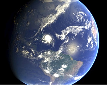
“Should you be worried about hurricanes? To find out, it is useful to know where hurricanes have gone in the past. The Earth map shows the path of every hurricane reported since 1851, Although striking, a growing incompleteness exists in the data the further one looks back in time. The Earth map graphically indicates that hurricanes — sometimes called cyclones or typhoons depending on where they form — usually occur over water, which makes sense since evaporating warm water gives them energy. The map also shows that hurricanes never cross — or even occur very near — the Earth’s equator, since the Coriolis effect goes to zero there, and hurricanes need the Coriolis force to circulate. The Coriolis force also causes hurricane paths to arc away from the equator. Although incompleteness fogs long term trends and the prevalence of hurricanes remains a topic of research, evidence is accumulating that hurricanes are, on the average, more common and more powerful in the North Atlantic Ocean over the past 20 years.”

Image Credit & Copyright: John Nelson, IDV Solutions

The eye of Hurricane Irene passes directly over the Delphi Club, Abaco 26 August 2011

The image below was shared on Facebook, but I don’t have the inventor’s name. I’m sorry not to be able to identify the originator of this ingenious hurricane warning. Every home should have one…