HURRICANE UPDATE: GONZALO TRACKS AWAY FROM ABACO, BAHAMAS
STOP PRESS – UPDATE Following yesterday’s post (below), the hurricane’s tendency to track further away from the Bahamas is confirmed by later models, for examples this one from Wunderground. So I think we are officially ‘off-risk’. But Bermuda is definitely not… Anyway, read on a bit and you will find out how hurricanes get their names!
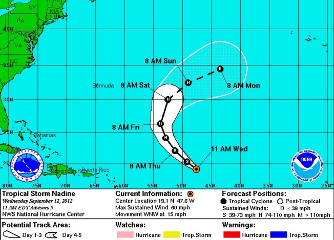
Yesterday I posted on my FB page an NOAA hurricane tracking map update for Hurricane Gonzalo, currently rated Cat. 2 on the SAFFIR-SIMPSON SCALE. It is making its way north through the Caribbean right now, and at one stage the storm cone looked on a possible course for the Bahamas. Abaco has been spared a major cyclone for a couple of years. However memories are very recent of Hurricane Irene (2011) which passed directly over Abaco as a Cat. 3 storm; and Hurricane Sandy (2012) that passed marginally to the east with (at that stage) an intensity of a Cat. 1 before going on to wreak havoc further north. During those ‘extreme weather events’ I posted regularly about them, with tracking maps and photos. At the time of Irene there was remarkable little information around online and I got a huge number of hits – 5000+ in a day, 15,000+ in a week. I also replied to lots of inquiries from the Bahamas, US and Canada, both general (“How are things at Cherokee?”) to very specific (“Do you happen to know if my boat ‘Blowdakidzinheritanz’ moored in Little Harbour is Okay?”).
I have been surprised at the response the map generated by way of ‘Likes’ and comments expressing relief… So from my current safe distance of precisely 4250.00 miles from Marsh Harbour, I am posting an update with helpful maps and a bit of general hurricane info. The agencies all agree that Gonzalo will hook east as it progresses northwards. The Bahamas outlook is promising, though for example Bermuda looks to be at risk. There’s more on hurricanes on the page ABACO WEATHER. I always think that Wunderground produce the clearest maps for general purposes, though there’s a great deal more information to be had from the NOAA site, to which there’s a direct link in the Sidebar (I’ve moved it to near the top for the time being).
CURRENT TRACKING FORECASTS OCT 14 2014
WUNDERGROUND 3-DAY TRACKING & WIND MAP 


NOAA TRACKERS & FORECASTS
ACCUWEATHER SATELLITE VIEW & TRACKER![]()
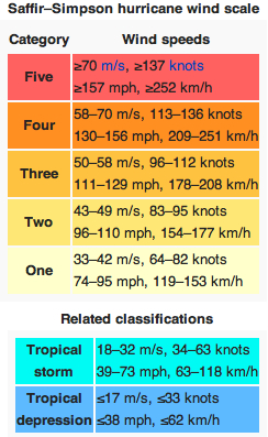
THE SAFFIR-SIMPSON SCALE
Here is a reminder of how tropical storms and hurricanes are measured for intensity, as decreed by the S-SS, followed by the National Hurricane Center’s explanation of the gradations of relative intensities.
The Saffir-Simpson Hurricane Wind Scale is a 1 to 5 rating based on a hurricane’s sustained wind speed. This scale estimates potential property damage. Hurricanes reaching Category 3 and higher are considered major hurricanes because of their potential for significant loss of life and damage. Category 1 and 2 storms are still dangerous, however, and require preventative measures. In the western North Pacific, the term “super typhoon” is used for tropical cyclones with sustained winds exceeding 150 mph.
| Category | Sustained Winds | Types of Damage Due to Hurricane Winds |
|---|---|---|
| 1 | 74-95 mph 64-82 kt 119-153 km/h |
Very dangerous winds will produce some damage: Well-constructed frame homes could have damage to roof, shingles, vinyl siding and gutters. Large branches of trees will snap and shallowly rooted trees may be toppled. Extensive damage to power lines and poles likely will result in power outages that could last a few to several days. |
| 2 | 96-110 mph 83-95 kt 154-177 km/h |
Extremely dangerous winds will cause extensive damage:Well-constructed frame homes could sustain major roof and siding damage. Many shallowly rooted trees will be snapped or uprooted and block numerous roads. Near-total power loss is expected with outages that could last from several days to weeks. |
| 3 (major) |
111-129 mph 96-112 kt 178-208 km/h |
Devastating damage will occur: Well-built framed homes may incur major damage or removal of roof decking and gable ends. Many trees will be snapped or uprooted, blocking numerous roads. Electricity and water will be unavailable for several days to weeks after the storm passes. |
| 4 (major) |
130-156 mph 113-136 kt 209-251 km/h |
Catastrophic damage will occur: Well-built framed homes can sustain severe damage with loss of most of the roof structure and/or some exterior walls. Most trees will be snapped or uprooted and power poles downed. Fallen trees and power poles will isolate residential areas. Power outages will last weeks to possibly months. Most of the area will be uninhabitable for weeks or months. |
| 5 (major) |
157 mph or higher 137 kt or higher 252 km/h or higher |
Catastrophic damage will occur: A high percentage of framed homes will be destroyed, with total roof failure and wall collapse. Fallen trees and power poles will isolate residential areas. Power outages will last for weeks to possibly months. Most of the area will be uninhabitable for weeks or months. |
HOW DO HURRICANES GET THEIR NAMES?
Check out the page ABACO WEATHER
BACKTRACKING


You must be logged in to post a comment.