HURRICANE MATTHEW & THE TRUE MEANING OF “AWESOME”


hurricane-matthew-nasa

Hurricane Matthew, NASA aerial view

HURRICANE MATTHEW & THE TRUE MEANING OF “AWESOME”

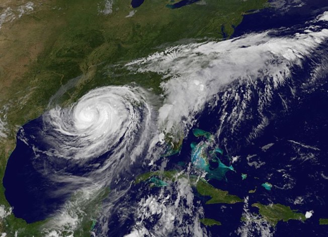
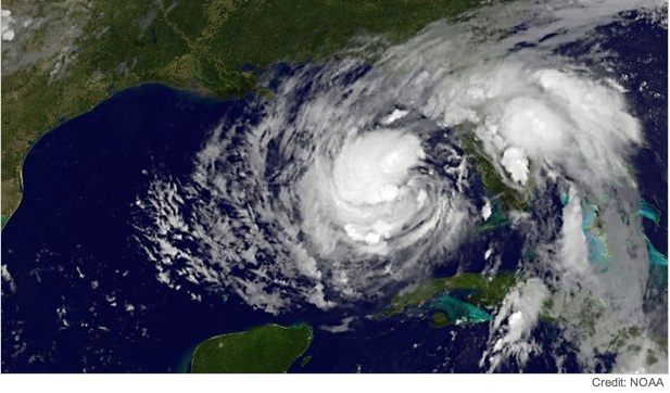
As Hurricane Matthew sweeps northwards, with Abaco in its path for the hit tomorrow, it’s an opportunity to take a look at the power and might of extreme weather, and maybe to recalibrate the word ‘awesome’ from its current diluted usage. The images used all relate to the state of play in the last 24 hours.

Hurricane Matthew_satellite view (NASA)

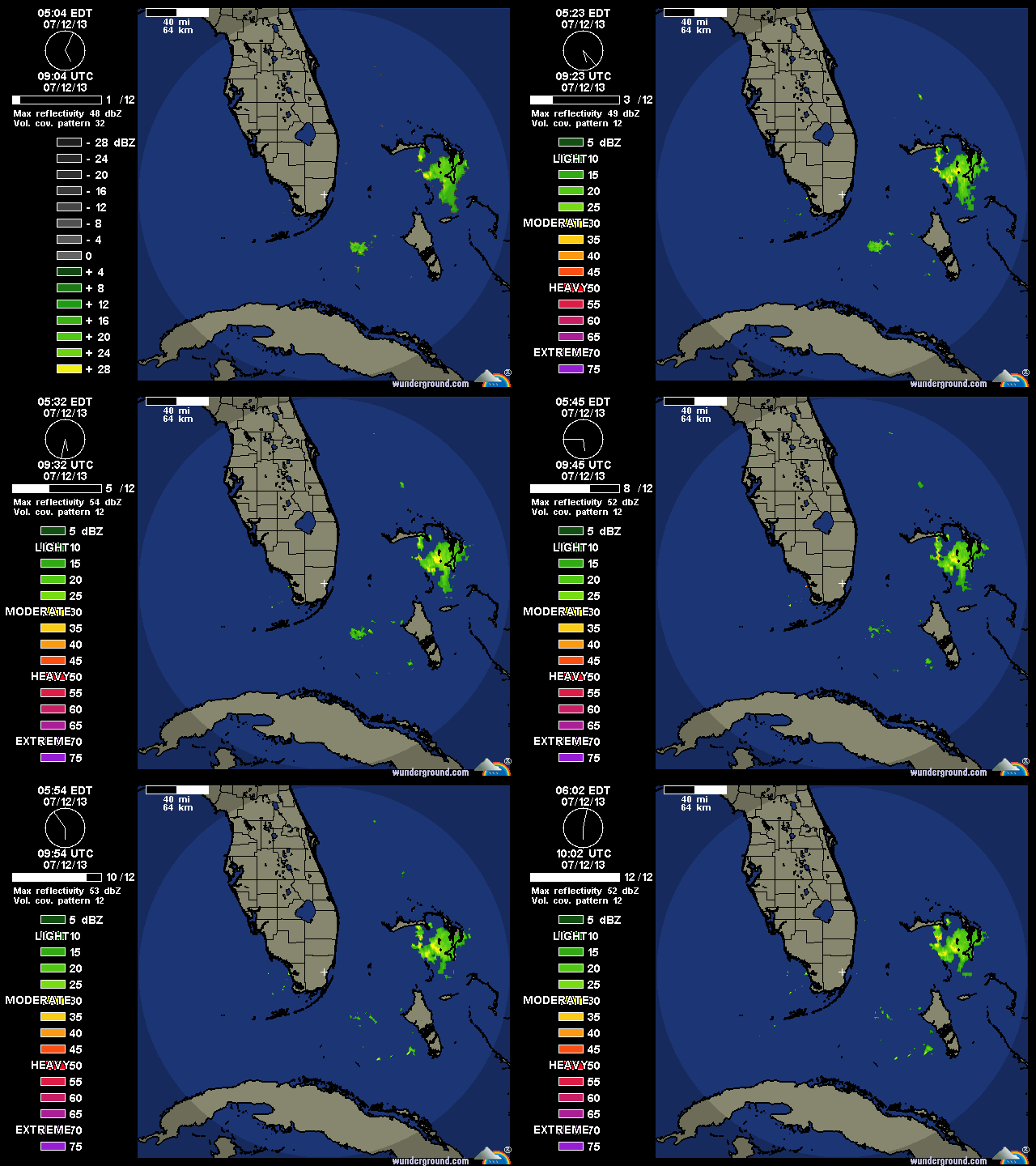
Satellite view at 14.00 EDThurricane-matthew-satellite-clip-wunderground

The concept of ‘awe’, historically and Biblically, comprised emotions such as wonderment, astonishment, terror and dread. Biblical translations use ‘awe’ and ‘awesome’ almost exclusively to refer to God or to His Works. In many Biblical instances of people being awed, they not only experience extremes of emotion but also exhibit palpable signs of fear – shaking, cowering, falling down, prostrating themselves.

Aerial view of Hurricane Matthew from the International Space Station, October 4hurricane-matthew- aerial view (ISS/ NASA)

The perfect example of the ‘proper’ meaning of awesome can be found in Genesis: ‘He (Jacob) was afraid and said, “How awesome is this place! This is none other than the house of God, and this is the gate of heaven.”‘ Some translations use the word ‘dreadful’ in place of ‘awesome’ for this passage – in its old meaning of ‘full of dread’, not its watered down modern meaning as in ‘dreadful headache’ or ‘dreadful nuisance’ (the same dilution that has happened to ‘terrible’).

Hurricane Matthew Tracking Path (Wunderground)

WHAT KIND OF EMOTION IS AWE?

In 1980 a man called Dr Robert Plutchik designed a ‘diagram of emotions’ in a floral wheel format. This device visualised eight basic emotions, with eight derivative emotions each composed of two basic ones. Awe is at 4.00 o’clock, showing the extreme of the Biblical meaning as a mixture of terror and amazement (think of the reaction of the shepherds while watching of their flocks, when unexpectedly interrupted by an angel…). There’s no place in the wheel for ‘awesome’ to mean ‘I really like that photo you took’. Or, ‘your soup is delicious’. Or, ‘I am so pleased to have made a plan to meet you at Pete’s Pub’.
plutchik-wheel-svg

Language is a living thing, and the hyperbolic application of powerful words to mundane emotions or objects is widespread and unsurprising. But a Cat. 4 hurricane really is awesome stricto sensu: it is both an amazing ‘extreme weather event’, and a terrifying one, as the header image and the many images of Matthew’s progress posted online amply  illustrate. The recent practice of  giving hurricanes comfortable names does nothing to dispel their power or the awe they inspire.  On present tracking, Matthew will reach Abaco some time tomorrow. From a safe distance, I wish everyone on Abaco and elsewhere in the target zone all the very best and a safe passage through the storm.

hurricane-matthew-wunderground-clip

HOW ARE HURRICANES CATEGORISED?

Credit: 'Watts Up With That" - Click image for Hurricane Irene page of this excellent weather & climate site

 FROM ASTOUNDING TO BADASS: AWESOME SYNONYMS ANCIENT & MODERN

Astounding, breathtaking, amazing, stunning, astonishing, awe-inspiring, stupendous, staggering, extraordinary, incredible, unbelievable, magnificent, wonderful, spectacular, remarkable, phenomenal, prodigious, miraculous, sublime, formidable, imposing, impressive, mind-boggling, mind-blowing, out of this world, supercalifragilisticexpialidocious, amazeballs, badass

hurricane-matthew-tracking-clip-craig-setzer-jpg-copy

Credits: Nasa / Goes, NASA / ISS, Wunderground, Craig Setzer

HURRICANE UPDATE: GONZALO TRACKS AWAY FROM ABACO, BAHAMAS


Hurricane Irene 2011 - the eye right on course for central Abaco

Hurricane Irene 2011 – the eye right on course for central Abaco

HURRICANE UPDATE: GONZALO TRACKS AWAY FROM ABACO, BAHAMAS

STOP PRESS – UPDATE Following yesterday’s post (below), the hurricane’s tendency to track further away from the Bahamas is confirmed by later models, for examples this one from Wunderground. So I think we are officially ‘off-risk’. But Bermuda is definitely not… Anyway, read on a bit and you will find out how hurricanes get their names! 
1901289_599770936795166_5297826701188883150_n

Yesterday I posted on my FB page an NOAA hurricane tracking map update for Hurricane Gonzalo, currently rated Cat. 2 on the SAFFIR-SIMPSON SCALE. It is making its way north through the Caribbean right now, and at one stage the storm cone looked on a possible course for the Bahamas. Abaco has been spared a major cyclone for a couple of years. However memories are very recent of Hurricane Irene (2011) which passed directly over Abaco as a Cat. 3 storm; and Hurricane Sandy (2012) that passed marginally to the east with (at that stage) an intensity of a Cat. 1 before going on to wreak havoc further north. During those ‘extreme weather events’ I posted regularly about them, with tracking maps and photos. At the time of Irene there was remarkable little information around online and I got a huge number of hits – 5000+ in a day, 15,000+ in a week. I also replied to lots of inquiries from the Bahamas, US and Canada, both general (“How are things at Cherokee?”) to very specific (“Do you happen to know if my boat ‘Blowdakidzinheritanz’ moored in Little Harbour is Okay?”).

Hurricane Sandy Earth from Space 2

Hurricane Sandy over Abaco from the International Space Station

I  have been surprised at the response the map generated by way of ‘Likes’ and comments expressing relief… So from my current safe distance of precisely 4250.00 miles from Marsh Harbour, I am posting an update with helpful maps and a bit of general hurricane info. The agencies all agree that Gonzalo will hook east as it progresses northwards. The Bahamas outlook is promising, though for example Bermuda looks to be at risk.  There’s more on hurricanes on the page ABACO WEATHER. I always think that Wunderground produce the clearest maps for general purposes, though there’s a great deal more information to be had from the NOAA site, to which there’s a direct link in the Sidebar (I’ve moved it to near the top for the time being).

CURRENT TRACKING FORECASTS OCT 14 2014 

WUNDERGROUND 3-DAY TRACKING & WIND MAP at201408at201408_satat201408_radar

NOAA TRACKERS & FORECASTS

085519203828W_NL_sm

ACCUWEATHER SATELLITE VIEW & TRACKERHurricane Gonzalo Tracking Map  - clip jpg

THE SAFFIR-SIMPSON SCALE

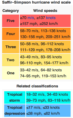
Here is a reminder of how tropical storms and hurricanes are measured for intensity, as decreed by the S-SS, followed by the National Hurricane Center’s explanation of the gradations of relative intensities.

Saffir-Simpson Scale (Wiki) jpgT

The Saffir-Simpson Hurricane Wind Scale is a 1 to 5 rating based on a hurricane’s sustained wind speed. This scale estimates potential property damage. Hurricanes reaching Category 3 and higher are considered major hurricanes because of their potential for significant loss of life and damage. Category 1 and 2 storms are still dangerous, however, and require preventative measures. In the western North Pacific, the term “super typhoon” is used for tropical cyclones with sustained winds exceeding 150 mph.

Category   Sustained Winds Types of Damage Due to Hurricane Winds
1 74-95 mph
64-82 kt
119-153 km/h
Very dangerous winds will produce some damage: Well-constructed frame homes could have damage to roof, shingles, vinyl siding and gutters. Large branches of trees will snap and shallowly rooted trees may be toppled. Extensive damage to power lines and poles likely will result in power outages that could last a few to several days.
2 96-110 mph
83-95 kt
154-177 km/h
Extremely dangerous winds will cause extensive damage:Well-constructed frame homes could sustain major roof and siding damage. Many shallowly rooted trees will be snapped or uprooted and block numerous roads. Near-total power loss is expected with outages that could last from several days to weeks.
3
(major)
111-129 mph
96-112 kt
178-208 km/h
Devastating damage will occur: Well-built framed homes may incur major damage or removal of roof decking and gable ends. Many trees will be snapped or uprooted, blocking numerous roads. Electricity and water will be unavailable for several days to weeks after the storm passes.
4
(major)
130-156 mph
113-136 kt
209-251 km/h
Catastrophic damage will occur: Well-built framed homes can sustain severe damage with loss of most of the roof structure and/or some exterior walls. Most trees will be snapped or uprooted and power poles downed. Fallen trees and power poles will isolate residential areas. Power outages will last weeks to possibly months. Most of the area will be uninhabitable for weeks or months.
5
(major)
157 mph or higher
137 kt or higher
252 km/h or higher
Catastrophic damage will occur: A high percentage of framed homes will be destroyed, with total roof failure and wall collapse. Fallen trees and power poles will isolate residential areas. Power outages will last for weeks to possibly months. Most of the area will be uninhabitable for weeks or months.

HOW DO HURRICANES GET THEIR NAMES?

Check out the page ABACO WEATHER

BACKTRACKING

Hurricane Irene 2011 Bahamas Map Accu jpg Hurricane Sandy Map Bahamas 2012 jpg

TROPICAL STORM CHANTAL HEADS FOR BAHAMAS & ABACO: REGULAR UPDATES


TS Chantal small

TROPICAL STORM CHANTAL HEADS FOR BAHAMAS & ABACO…

EX-CHANTAL ACTIVE AFTER-EFFECTS FOR BAHAMAS JULY 12

WUNIDS_map

… AND DISSIPATES AS AT 17.00 EDT July 10

TD Chantal dissipated NOAA

UPDATE NOAA 11.00 EDT July 10

The storm path seems to be drifting gradually westwards. Abaco is now clear of the currently predicted path, rather than slap bang in the middle…

Chantal NOAA 10.7 11.00

UPDATE NOAA 6.00 EDT July 10

084552W5_NL_sm

084552

UPDATE INTELLICAST 17.00 July 9  Intellicast 9.07.13 17.00

ORIGINAL POST

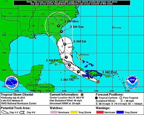
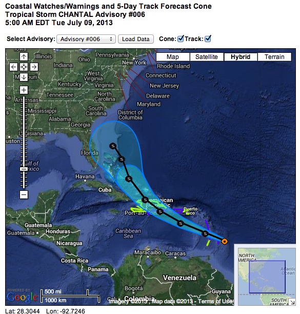
The 9th July, the season of storms starts to loom, and Chantal is first off the meteorological starting blocks. The reason I am posting this now is because the present 5-day predictions (see NOAA charts below) has Chantal heading directly for the Bahamas in general, and Abaco in particular. So this may be one to keep a weather eye on over the next few days…

NOAA GraphicNOAA imageTS Chantal 9.7 1 NOAA Image

HURRICANE SANDY: CUBA, BAHAMAS (TRACKING / PATH MAPS, LATEST ABACO UPDATES 25 OCTOBER)


20121027-192522.jpg

HURRICANE SANDY HEADING NORTH FOR BAHAMAS

INTERACTIVE STORM TRACKER

Type in your location for current path predictionClick Pic!

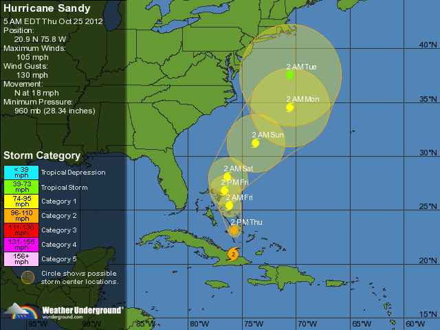
UPDATE 25 OCT 05.00 EDT HURRICANE SANDY CLEARING CUBA AS CAT. 2

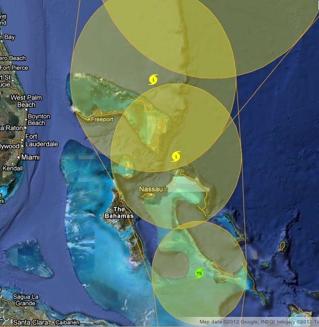
Three hours passing has made a further difference, and not for the better. The landmass of Cuba, far from slowing the storm, has seen it intensify to Cat 2 – though so far that is predicted only as far as the south Bahamas… (Map 1). However the eastward drift into the Atlantic is still detectable – see Abaco detail, Map 2

UPDATE 25 OCT 02.00 EDT HURRICANE SANDY MAKES CUBA LANDFALL

As Sandy reaches the south coast of Cuba, two things have become clear overnight. First, the storm’s strength is now predicted at Cat 1 until it clears into the Atlantic north of the Bahamas – there will be no reduction to TS status in the south Bahamas (Map 1) Secondly, the news for Abaco is that a slight drift of the spine of the storm to the east can be detected (see Abaco Detail, Map 2). Yesterday, the eye was due to pass pretty much directly over MH and indeed (like Irene last year) the Delphi Club and Rolling Harbour. The shift may of course have no significant effect on the storm’s power, but if the eye’s path could continue to drift further east… Map 3 is the ‘hot’ map from 04.00 EDT today

FLIGHT ADVISORY As many on Abaco may already have found, there are flight disruptions from Nassau – I know of one person who couldn’t get to MH last night. So visitors following this blog and planning an imminent flight need to keep a careful eye on the situation, which given the path of the storm is likely to worsen.

I will not be in a position to post much in the way of updates between now and Monday – by which time Sandy should have cleared to the north of the Bahamas. The interactive tracker link at the top of this page is an excellent resource, especially as you can input a precise location. There is luckily a wealth of information out there on the internet – far more than for Irene last year. I notice too that Abaco residents are busy exchanging information on Facebook. While we are away, we’ll be thinking of all those in the path of the storm…

UPDATE 24 OCT 18.00 EDT HURRICANE SANDY CROSSING JAMAICA

Sandy is now a Cat 1 hurricane as it crosses Jamaica and heads for eastern Cuba. As the latest projections show, the prospects for the Bahamas have worsened: hurricane force is expected over central and northern islands (see map below for Abaco detail)

DETAILED TRACKING PATH FOR THE BAHAMAS 24 OCTOBER 18.00 EDT

NATIONAL HURRICANE CENTER UPDATE EXTRACT 24 OCT 16.00 EDT

THE EYE OF HURRICANE SANDY MADE LANDFALL ON THE SOUTHEASTERN COAST
OF JAMAICA NEAR KINGSTON AT APPROXIMATELY 3.00 PM EDT / 19.00 UTC
MAXIMUM SUSTAINED WINDS AT LANDFALL WERE ESTIMATED TO BE 80 MPH / 130 KM/H
======================================
HURRICANE SANDY ADVISORY NUMBER 9 NWS NATIONAL HURRICANE CENTER MIAMI FL 1100 AM EDT WED OCT 24 2012 
SANDY REACHES HURRICANE STRENGTH... CONDITIONS DETERIORATING IN JAMAICA... 

CHANGES WITH THIS ADVISORY 
THE GOVERNMENT OF THE BAHAMAS HAS ISSUED A HURRICANE WATCH FOR CENTRAL AND NORTHWESTERN BAHAMAS 

SUMMARY OF WATCHES AND WARNINGS IN EFFECT

A HURRICANE WARNING IS IN EFFECT FOR JAMAICA and [SPECIFIED] REGIONS OF CUBA 
A TROPICAL STORM WARNING IS IN EFFECT FOR HAITI, THE CENTRAL BAHAMAS, THE NORTHWESTERN BAHAMAS 
A HURRICANE WATCH IS IN EFFECT FOR THE CENTRAL BAHAMAS, THE NORTHWESTERN BAHAMAS 
A TROPICAL STORM WATCH IS IN EFFECT FOR THE SOUTHEASTERN BAHAMAS, FLORIDA EAST COAST FROM THE VOLUSIA/BREVARD
COUNTY LINE TO OCEAN REEF, FLORIDA UPPER KEYS FROM OCEAN REEF TO CRAIG KEY, FLORIDA BAY

UPDATE 24 OCT 05.00 EDT TS SANDY MARCHES NORTH OVER JAMAICA

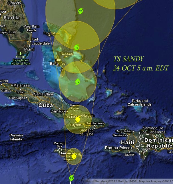
The latest maps below show TS / Hurricane Sandy at 5 am EDT today. Map 3 is the most useful for the current detailed Abaco prediction. Meanwhile, the US news indicates increasing concerns further north (much as happened with Irene last year)

TS SANDY POSITION & PROJECTED PATH 24 OCT 5.00 am EDTTS SANDY 5-DAY FORECAST 24 OCT 05.00 am EDT

TS SANDY DETAILED TRACKER 24 OCT 5.00 am EDT

TS SANDY POSITION & PROJECTED PATH 24 OCT 5.00 am EDT

CONCERN IS INCREASING FOR TS SANDY’S PATH UP THE US EAST COAST…

UPDATE 23 OCT 23.00 EDT TS Sandy is now approaching Jamaica.

Continue reading

TROPICAL STORM SANDY: HEADING FOR BAHAMAS (TRACKING / PATH MAPS, LATEST ABACO UPDATES 24 OCTOBER)


HURRICANE SANDY HEADING NORTH FOR BAHAMAS

INTERACTIVE REAL-TIME STORM TRACKER

Type in your location for current path predictionClick Pic!

UPDATE 24 OCT 18.00 EDT HURRICANE SANDY CROSSING JAMAICA

Sandy is now a Cat 1 hurricane as it crosses Jamaica and heads for eastern Cuba. As the latest projections show, the prospects for the Bahamas have worsened: hurricane force is expected over central and northern islands (see map below for Abaco detail).

I will not be in a position to post much in the way of updates between now and Monday – by which time Sandy should have cleared to the north of the Bahamas. The interactive tracker link at the top of this page is an excellent resource, especially as you can input a precise location. There is luckily a wealth of information out there on the internet – far more than for Irene last year. I notice too that Abaco residents are busy exchanging information on Facebook. While we are away, we’ll be thinking of all those in the path of the storm… 

DETAILED TRACKING PATH FOR THE BAHAMAS 24 OCTOBER 18.00 EDT

NATIONAL HURRICANE CENTER UPDATE EXTRACT 24 OCT 16.00 EDT

THE EYE OF HURRICANE SANDY MADE LANDFALL ON THE SOUTHEASTERN COAST
OF JAMAICA NEAR KINGSTON AT APPROXIMATELY 3.00 PM EDT / 19.00 UTC
MAXIMUM SUSTAINED WINDS AT LANDFALL WERE ESTIMATED TO BE 80 MPH / 130 KM/H
======================================
HURRICANE SANDY ADVISORY NUMBER 9 NWS NATIONAL HURRICANE CENTER MIAMI FL 1100 AM EDT WED OCT 24 2012 
SANDY REACHES HURRICANE STRENGTH... CONDITIONS DETERIORATING IN JAMAICA... 

CHANGES WITH THIS ADVISORY 
THE GOVERNMENT OF THE BAHAMAS HAS ISSUED A HURRICANE WATCH FOR CENTRAL AND NORTHWESTERN BAHAMAS 

SUMMARY OF WATCHES AND WARNINGS IN EFFECT

A HURRICANE WARNING IS IN EFFECT FOR JAMAICA and [SPECIFIED] REGIONS OF CUBA 
A TROPICAL STORM WARNING IS IN EFFECT FOR HAITI, THE CENTRAL BAHAMAS, THE NORTHWESTERN BAHAMAS 
A HURRICANE WATCH IS IN EFFECT FOR THE CENTRAL BAHAMAS, THE NORTHWESTERN BAHAMAS 
A TROPICAL STORM WATCH IS IN EFFECT FOR THE SOUTHEASTERN BAHAMAS, FLORIDA EAST COAST FROM THE VOLUSIA/BREVARD
COUNTY LINE TO OCEAN REEF, FLORIDA UPPER KEYS FROM OCEAN REEF TO CRAIG KEY, FLORIDA BAY

UPDATE 24 OCT 05.00 EDT TS SANDY MARCHES NORTH OVER JAMAICA 

The latest maps below show TS / Hurricane Sandy at 5 am EDT today. Map 3 is the most useful for the current detailed Abaco prediction. Meanwhile, the US news indicates increasing concerns further north (much as happened with Irene last year) Continue reading

HURRICANE ISAAC LATEST UPDATES 30 AUGUST; IMAGES; TRACKING; MAPS; SAFFIR-SIMPSON SCALE


AUGUST 30

Noon GMT Some more pictures overnight – a selection of clips from a short HuffPo video

AUGUST 29

22.00 GMT Latest news: Hurricane Isaac has just been downgraded to a Tropical Storm (I realise that for those caught up in the heart of flooding, damage and widespread outages, this may be of little practical comfort – but it is perhaps some encouragement for those further north in the path of the storm).

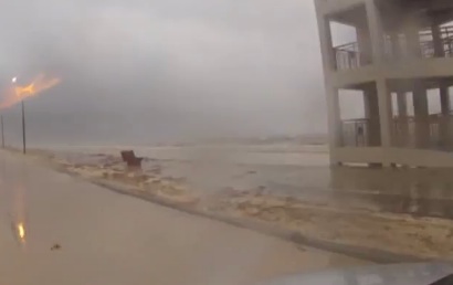
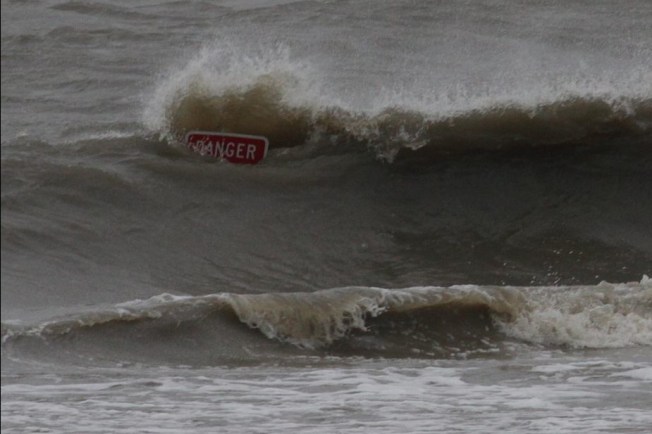
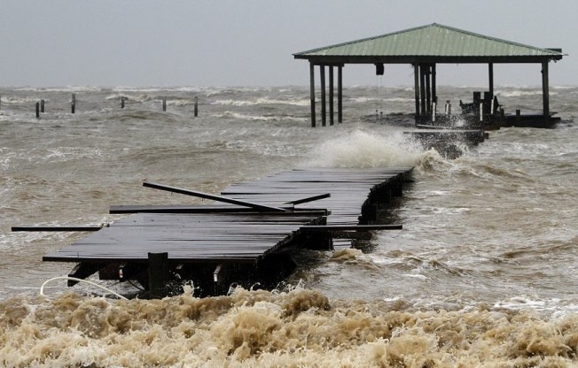
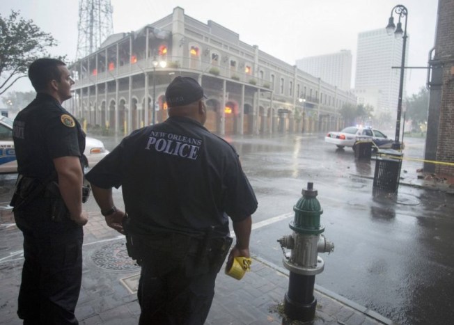
18.00 GMT Some pictures are now coming out giving an idea of the ferocity of the storm. I’ve assembled a short gallery from Reuters, AP/Getty and similar news resources, which I will add to as and when…

DANGER SIGNWRECKED PIERHURRICANE CHANCERS… ARE THEY CRAZY?NEW ORLEANS POLICE ON PATROLUPROOTED TREEBUILDING DAMAGEROUGH SEASFALLEN TREEIS THIS WOMAN BEING SENSIBLE?

NOA SATELLITE IMAGE AUGUST 29th

Noon GMT The latest Wunderground tracker map for Hurricane Isaac shows the storm’s current position and its subsequent path, decreasing to tropical storm and then tropical depression as it sweeps northwards through Arkansas. The eastwards tendency, noted previously, is now pronounced with the storm predicted to turn towards Missouri and Kentucky.

09.00 GMT Having had many hundreds of hits for this storm post, including a great many from the southern coastal states of the US, I am posting some further information about Hurricane Isaac today, as the storm rages over New Orleans and more widely across the state. 

I have been wondering about the New Orleans flood defences that are constantly referred to in news reports, so firstly here is a clear map of the situation showing the reinforcement since Hurricane Katrina 

Here is a satellite video of Hurricane Isaac approaching the US coast, taken over two days. It vividly shows the development in the Gulf of Mexico from a “disorganised” tropical storm into a swirling, concentrated hurricane-force storm, with the eye becoming visible as it approaches the coast.

Finally (for now) this is the astonishing view from a space station, giving an idea of the storm’s extent

AUGUST 28

Posting suspended

AUGUST 27

TS ISAAC STORM TRACKING: LATEST UPDATE 23.00 GMT

GOES satellite image of TS Isaac 27 August Noon

TS ISAAC STORM TRACKING: LATEST UPDATE 09.00 GMT

Here is this morning’s (GMT) tracking map, with the storm in the Gulf of Mexico, still drifting westwards. Predicted landfall is now mainly on the Louisiana coast. The most significant change overnight is that the Cat 2 prediction has been downgraded, so that the max expected strength is Cat 1

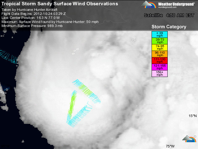
The satellite picture shows Isaac thickly covering the Gulf of Mexico with dense cloud. The coloured markings to the right show the data recorded by the NOAA Hurricane Hunter flying on the eastern edge of the storm (where the winds are less)

Since this is a Bahamian-based blog (with close Florida connections) Isaac’s current position makes this a suitable moment to return to the main business of Rolling Harbour – the wildlife of Abaco. At exactly this time last year, Hurricane Irene was passing directly over Abaco, with the eye going right over HQ at the Delphi Club. The northward passage of Isaac has of course affected the weather there, but it has been spared the ferocity of 2011. We’ll be thinking of course about all those in the US in Isaac’s path when landfall is made shortly

AUGUST 26

I have concentrated for obvious reasons on the projected path of Isaac with special reference to its proximity to the Bahamas in general, and Abaco in particular. I may have given the impression that the continuing westward movement of the storm’s path has meant that Abaco would enjoy glorious dawns, wonderful sunny days and spectacular sunsets. Not so, of course – the side-effects of the storm continue laterally for large distances. It’s lunchtime on Abaco now, and a message from Brigitte Carey on Tilloo Cay says simply “Yes, its nasty here – lots of wind and rain!”

TS ISAAC STORM TRACKING: LATEST UPDATE 16.00 GMT

First, a recent satellite image of the developing Cat 1 hurricane, still expected to reach Cat 2 as it make landfall on the southern US coast, followed by a tracker map confirming the westward tendency of the predicted path Continue reading