Unknown's avatar

BROKEN NEWS: HOSPITALISED COMPUTER…


Turkey Vulture, Abaco (Craig Nash)

BROKEN NEWS: HOSPITALISED COMPUTER…

My computer has caught a bad virus

Which is decidedly less than desirous.

This bout of malwaria

Could hardly be scarier –

I’d prefer to endure Miley Cyrus…

Normal service will be restored once the gremlins have been professionally terminated

Photos: Craig Nash (contributor to Birds of Abaco)

Unknown's avatar

‘RAISE AWARENESS’: SPOTTED EAGLE RAYS


Spotted Eagle Rays, Abaco, Bahamas (Gabrielle Manni)

Spotted Eagle Rays – Abaco, Bahamas

‘RAISE AWARENESS’: SPOTTED EAGLE RAYS

Mention of rays may conjure up thoughts of the familiar southern stingrays that populate the bright shallows and colourful reefs of the Bahamas. But there are other ray species out there gracefully patrolling the coral reefs – and one of these species is the spotted eagle ray (Aetobatus narinari).

Spotted Eagle Rays, Abaco, Bahamas (Catherine / Tara Pyfrom)

These fish (for that is what they are) are not uncommon. In fact they are found in tropical oceans worldwide (though there is a taxonomic distinction between the Atlantic version and the Pacific / Indo-Pacific ones). Note the concentration in the Caribbean sea.

Spotted Eagle Rays, Grand Bahama, Bahamas (Melinda Riger / GB Scuba)

Spotted eagle rays obviously have spots, but they are not notably eagle-like to look at. In fact, their snouts resemble a duck’s bill, and in some place they are less glamorously known as the duckbill ray. The ‘eagle’ part relates to the way in which they use their wings and appear to be soaring as they glide effortlessly through the water (see videos below).

Spotted Eagle Rays (Lazlo-photos Wiki)

Despite their global presence, these rays are categorised as ‘near-threatened’ on the IUCN Red List. Aside from vulnerability to predators including many types of shark, the rays may be caught as bycatch. In some areas they suffer entanglement in shark nets. And unsurprisingly there is a trade for them for large commercial aquariums. For the Atlantic species, Florida has taken a lead by banning fishing for, landing, buying or trading in spotted eagle rays. 

Spotted Eagle Rays, Abaco, Bahamas (Gabrielle Manni)

10 ESSENTIAL FACTS ABOUT SPOTTED EAGLE RAYS

  • They have 2 – 6 venomous barbed spines at the base of the tail
  • Adults are among the largest rays, with a 10 ft wingspan
  • They can leap clear of the water, and may do this more than once at a time
  • Occasionally they land in boats, to the consternation of all concerned
  • Their main diet is small fish and crustaceans, & sometimes octopuses
  • Their broad snouts are used to dig food out of the seabed as they forage
  • The rays are basically shy but may be curious of divers & snorkellers
  • They suffer from parasites, both externally and in their gills
  • Ray sex is quite physical, yet actual mating is brief (up to 90 secs…)
  • The female hatches her eggs internally, then her ‘pups’ are born live a year later

SPOTTED EAGLE RAY PUP


Spotted Eagle Ray (John Norton Wiki)

 VIDEO SHOWCASE
These 3 short videos demonstrate the grace and beauty of spotted eagle rays as they glide elegantly around the reefs. The first (50s) was taken off Grand Bahama by Fred Riger (Melinda’s husband, for those who follow the underwater forays hereabouts); then one by Stephen Dickey (2:12) ; and finally one from Wildscreen Arkive (2:00).

WEIRD CREATURE CORNER

I have a lot of time for these cards produced by ‘Weird ‘n’ Wild Creatures’. In their unique style they are simple, educative and often give information nuggets not found elsewhere. The link is to their 4th series, Monsters of the Deep.


Photo credits: Gabrielle Manni (1), (5); Catherine & Tara Pyfrom (2); Melinda Riger / Grand Bahama Scuba (3); Lazlo-photos Wiki (4); Wiki (baby ray thumbnails); John Norton Wiki (6); Jacob Robertson Wiki (7); Weird ‘n’ Wild Creatures – card images. Videos as credited in text.

Spotted Eagle Ray, TCI (Jacob Robertson, Wiki)
Unknown's avatar

LEAST (BUT NOT LAST) SANDPIPERS ON ABACO


Least Sandpiper, Delphi Beach, Abaco (Charles Skinner)

LEAST (BUT NOT LAST) SANDPIPERS ON ABACO

There are 23 sandpiper species recorded for Abaco. Of those, 4 or 5 are vanishingly rare vagrants recorded once or twice in recent history (i.e. since about 1950).

Discounting those, the ones you are likely to encounter range from the large  (whimbrel, yellowlegs, dowitchers, stilts) to the small. Or, in the case of the least sandpiper, the least big of all. They are bigly little. Least Sandpiper, Delphi Beach, Abaco (Charles Skinner)

The binomial name of the least sandpiper – Calidris minutilla – is an apt clue to their size, the second part being Latin for “very small”. On Abaco, they are fairly common winter visitors, and each season a handful of them make their home on the beach at Delphi, where these photos were taken. Least Sandpiper, Delphi Beach, Abaco (Charles Skinner)

Along with their small sandpiper compadres such as SANDERLING, these busy, bustling birds of the shoreline are the ones known as “peeps” (also as stints). Least Sandpiper, Delphi Beach, Abaco (Charles Skinner)

Least Sandpipers breed in the northern tundra areas of North America. Like many or most shorebirds, newly hatched chicks are able to fend for themselves very quickly. It sounds unlikely I know, but within a couple of weeks or so they have fledged. Least Sandpiper, Delphi Beach, Abaco (Charles Skinner)

The birds forage on mudflats, in the tideline on beaches, and in wrack. They will probe into soft sand, sometimes the full length of their beak. They will even burrow right under weed to get at the concealed goodies. Their diet consists mainly of small crustaceans, insects, and snails.Least Sandpiper, Delphi Beach, Abaco (Keith Salvesen)

Credits: All photos by Charles Skinner (contributor to “The Birds of Abaco”) except the wrack-burrowers above, by Keith Salvesen (also on the Delphi Beach).

Least Sandpiper, Delphi Beach, Abaco (Charles Skinner)

Unknown's avatar

A GREAT EGRET MAKES A SPLASH…


A GREAT EGRET MAKES A SPLASH…

I’m quite a  fan of bird action sequences. Top quality ones, I mean, not the rubbishy ones that I have tried to accomplish with either (a) a camera I understand but is not sophisticated enough for such use; or (b) a more serious camera that I never got the hang of, was secretly a bit ‘overawed by’ (= scared of), and which met a watery end when I was photographing sanderlings on the beach while standing in the sea…

Among the photographers who kindly let me use their images from time to time are a couple who are especially adept with sequential shots. One is Danny Sauvageau, a Floridian who combines great bird photography with a tireless capacity for tracking down banded birds at migration time. Here is his Great Egret catching breakfast.

Credits: All fantastic photos by Danny Sauvageau, with thanks as ever for use permission; cartoon, the very excellent Birdorable


Unknown's avatar

AN ‘EXHILARATION’ OF ABACO DOLPHINS


Bottlenose Dolphins, Abaco Bahamas (BMMRO)

AN ‘EXHILARATION’ OF ABACO DOLPHINS

Bottlenose dolphins! Tursiops truncatus! These engagingly playful show-offs of the inshore waters round Abaco are 99.99% adorable**. It’s been a harrowing few weeks in the western Atlantic, and everyone is hoping that the 2017 hurricane season has had enough of causing death and destruction over vast swathes of vulnerable islands and on the US mainland. Some cheer is needed.

Bottlenose Dolphins, Abaco Bahamas (BMMRO)

Dolphins are good for the soul. And if you are out on a boat watching them – and especially tracking them for a whole day – every encounter reinforces the impression that all the leaping, bow-wave riding, boat under-swimming, and general sociability and interaction is often as much for sheer enjoyment as anything else. 

Bottlenose Dolphins, Abaco Bahamas (BMMRO)

Abaco is fortunate in having the HQ of the Bahamas Mammals Research Organisation (BMMRO) based at Sandy Point. That just happens to be an excellent area for bottlenose dolphin spotting in the turquoise shallows. Many sightings are made within clear sight of land. Further south, where the bright blue gives way to darker and deeper water, live the equally frolicsome Atlantic spotted dolphins. The 3 photos above were all taken on the margins of where the colour of the sea changes from light to dark.

Bottlenose Dolphins, Abaco Bahamas (BMMRO)

I’m a bit of a collector of collective nouns. For dolphins, apart from the matter-of-fact ‘group’ or ‘pod’, there is no exotic word to describe a number of them when they are having fun. No equivalent of ‘exaltation’ (larks), ‘charm’ (goldfinches) or ‘parliament’ (owls). So I’m nominating an ‘exhilaration’ as a candidate to fill the gap…

The photo above shows clearly how individual dolphins can be identified by researchers. All tend to have scars or tears to their dorsal fins that enable them to be distinguished. The closest has distinctive scars near the tip. The furthest has a W-shaped nick at the back. In fact, it could even be Rocky, a well-known dolphin on Abaco that has been sighted over many years. There are regular reports annually. I saw him myself once, in 2012, playing about in Hopetown harbour. 

STOP PRESS To demonstrate how the ID methods work, I’ve now cross-checked with the BMMRO photo ID archive. Here is Rocky’s original dorsal fin ID image (“Tt15”) from October 2010. There’s a W-shaped nick, sure, but my speculation above was wrong because overall the two fins are clearly different…

Rocky the Dolphin Tt15, from BMMRO ID photo archive

** The 0.01%? Dolphins may, rarely, be alarming for divers in circumstances I won’t repeat here (hint: to do with over-friendliness, ok? Yes, the thing that dogs do)

Credits: all photos BMMRO – and taken in the last 2 months

Unknown's avatar

QUEEN TRIGGERFISH AND GOOD RIDDANCE TO MARIA


Queen Triggerfish Bahamas (Melinda Riger / Grand Bahama Scuba)

QUEEN TRIGGERFISH AND GOOD RIDDANCE TO MARIA

I can think of no sensible connection between the colourful yet undoubtedly strange and grumpy-looking looking queen triggerfish Balistes vetula, and a hurricane. However, Hurricanes Irma and Maria have been rightly dominating the news and everyone’s thoughts for nearly 3 weeks now. And most of the recent posts from Rolling Harbour, for that matter. It’s not been a great time for looking at the birds, beasts and fishes. So, as Maria drifts eastwards and away from the Bahamas into the open ocean, it’s time for a splash of colour – and a fish I have not featured before. 

Hurricane Maria tracking at 11.00 EST on Sept 22

Queen Triggerfish Bahamas (Melinda Riger / Grand Bahama Scuba)Queen Triggerfish Bahamas (Melinda Riger / Grand Bahama Scuba)

The queen triggerfish, sometimes known as an Old Wife, is an Atlantic reef fish. This species is sometime fished for as game, and I know that a few have been taken from off the rocks at the south end of Delphi beach over the years – though perhaps not exactly on purpose.

Queen Triggerfish Bahamas (Mark Peter, Wiki)Queen Triggerfish Bahamas (Melinda Riger / Grand Bahama Scuba)

This fish typically is coloured with shades of  blue, purple, turquoise and green with a yellowish throat, with pale blue lines fins on head and fins. It’s minor superpower is to be able to change its coloration to some extent to match its reef surroundings and assist camouflage. Its favourite food is the sea urchin.

Queen Triggerfish Bahamas (Clark Anderson / Aqua-images)

Let’s hope this is the last post to feature anything about hurricanes for a good long time, as we think of all those still struggling to make sense of the terrible destruction they have recently experienced – in some places, twice over.

Credits: Melinda Riger / Grand Bahama Scuba; Mark Peter, Wiki; Clark Anderson / Aqua-images

Unknown's avatar

HURRICANE MARIA: TRACKING UPDATE for SEP 20th (Abaco, Bahamas)


HURRICANE MARIA: TRACKING UPDATE SEP 20th

Abaco, Bahamas

Hurricane Maria is currently passing over Puerto Rico as a Cat 4 on the Saffir-Simpson Scale. The big question for those to the north-west in general and (for this blog) Abaco in particular is, has the storm’s swerve to the east continued? And it’s now clear that the tendency has indeed been maintained. This means that today, more of the Bahamas Islands are now free for now from the cone of the predicted path. Here are the latest trackers for 11.00 am EDT today.

CURRENT POSITION

PREDICTED PATH

For the Abacos, the situation continues to improve for the moment at least. It’s certainly way too soon to be sure, but right now the outlook is good. And of course, Abaco may still experience a buffeting as the storm gradually progresses to the east. 

LOOKING FORWARD

Here is an estimate – and only that – of the position of Maria in relation to Abaco on Saturday Sep 23 at noon, if the current course holds. It will be a close shave, for sure.

Credits: NOAAW / GOES; GOES East; NASA; Wunderground; Accuweather; NOAA / NHC; Windy.com STAY SAFE

Unknown's avatar

HURRICANE MARIA: TRACKING UPDATE SEP 19th (Abaco, Bahamas)


HURRICANE MARIA: TRACKING UPDATE SEP 19th

Abaco, Bahamas

In the life of a massive Cat. 5 hurricane, a lot can happen over 24 hours. One source reports ‘mind-boggling devastation’ on Dominica. Other islands on the storm’s path are braced for their own tragedies for their populations, many still reeling from the passage of Irma just 2 weeks ago. Here are the latest trackers for 11.00 am EDT today; and a calculated prediction for the position on Friday midnight.

CURRENT POSITION

PREDICTED PATH

The first thing to note is that (after a slight drop in wind speed) the storm has now intensified to become Cat. 5. In due course wind speeds are expected to reduce gradually, as shown, but of course it won’t necessarily turn out that way.

For the Abacos, however, the situation is notably better that this time yesterday, when the islands were squarely with the cone (though not right at the centre). However the distinct tendency of Maria to hook right / east that was evident yesterday has increased to the extent that Abaco – and indeed the northern Bahamas – is no longer within the cone. Much the same happened with Irma. Both sources below show a similar prediction. Again, it won’t necessarily turn out that way, but there’s at least some encouragement for a better outlook. And of course, this does not mean that Abaco won’t get some heavy weather as Maria moves on…

LOOKING AHEAD

I’ve used a realtime tracker and moved it forward along its timeline to midnight on Friday. I’ve centred the prediction on South Abaco (white circles). There’s plenty of scope for the course to alter in the meantime, but the model suggests the main storm will progress mainly to the east of the Bahamas – and if the veer continues, then the more so for the northern islands. But remember – the predictions are just that and no more…

Credits: NOAAW / GOES; GOES East; NASA; Wunderground; NOAA / NHC; Windy.com STAY SAFE

Unknown's avatar

HURRICANE MARIA 2017: TRACKING THE NEW THREAT


HURRICANE MARIA 2017: TRACKING THE NEW THREAT

‘A PROBLEM LIKE MARIA’ feat. ‘DROP OFF THE QUAY, LEE’

It never rains, but it pours. Sometimes doubly so. Just as those so cruelly affected by Irma are beginning to deal with the trail of terrible damage and destruction of the huge hurricane, so another storm, Maria, approaches along a similar path. This has now been upgraded from a tropical storm to a Cat. 1 hurricane, and is expected to continue to pick up intensity.

The trackers below were all updated early this morning. The good news is that Lee is forecast to break up and dissipate. So at the moment, that threat can probably be discounted. Maria, on the other hand, is one to watch with eagle eyes: already on course to reach the Leeward Islands today, then expected to intensify and probably reach the Virgin Islands and Puerto Rico as a Cat 3 or 4 hurricane by Wednesday. After that, the storm looks set to pass Hispaniola and may hit the Turks and Caicos by Friday unless there’s a more significant hook to the right along the way. Beyond that, the Bahamas…

You may wonder why I put in 3 or 4 trackers of the many that are out there. It’s because they each present the information in a slightly different way. Some are easy to interpret; some are overloaded with info or otherwise confusing; some seem to me to be less accurate. The ones here are the ones I have used and found useful (= clear and reliable) since 2011, Hurricane Irene…

OPTIONAL MUSICAL DIGRESSION

I initially decided to omit my usual OMD, often added when a relevant song gets name-checked hereabouts. Then I rethought it. I’m not meaning to be frivolous nor to downplay the seriousness of extreme weather events on all those so badly affected.  But on the other hand, there are a few things that can lighten the spirit, albeit briefly. A really well put together song with clever lyrics is one such. Get rid of the squall, Paul; Drop off the quay, Lee; Just sing ‘see ya, Maria’; 

Credits: NOAAW / RAMMB / GOES; GOES East; Wunderground; NOAA / NHC; Paul Simon

Unknown's avatar

AFTER THE STORM: ALL THINGS BRIGHT & BEAUTIFUL


Abaco (Cuban) Parrot (Melissa Maura)

ABACO PARROT

AFTER THE STORM: ALL THINGS BRIGHT & BEAUTIFUL

For tens of thousands of people, the past 2 weeks have been dominated by one cruelly aggressive female: Irma. In terms of a lucky escape, Abaco’s gain was elsewhere’s pain. Recently, only the vivid Wunderground trackers I have posted have stood out from the bleakness of the ominous clouds, pounding waves, and sluicing rain. With the prospects for Hurricane Jose wandering around in the mid-Atlantic looking increasingly good, it’s time for a look at something more cheerful.

Birds can lighten the spirit. As yet, I’ve seen few reports of how the birds on Abaco have fared, but the ones I have seen have been encouraging. A west-indian woodpecker back on his usual tree; a piping plover foraging on the beach at Winding Bay, even as the storm raged; bird business more or less as usual at Delphi. No news yet of Abaco’s iconic parrots, which will have most likely headed to the National Park for cover. They usually manage OK. The header image is a tip of the hat to them, their raucous beauty, and their healthy recovery from near-extinction over the last few years.

Here’s a small gallery of some of Abaco’s most colourful and striking birds for some light relief. Have a nice day!

Painted Bunting, Abaco, Bahamas - Tom SheleyBananaquit, Abaco, Bahamas - Keith SalvesenWestern Spindalis, Abaco, Bahamas - Craig NashWhite-cheeked (Bahama) Pintail, Abaco, Bahamas - Keith SalvesenCuban Emerald Hummingbird, Abaco, Bahamas - Keith SalvesenBahama Woodstar, Abaco, Bahamas - Tom SheleyBlack-necked Stilt, Abaco, Bahamas - Tom SheleyCuban Pewee, Abaco, Bahamas - Keith SalvesenOsprey, Abaco, Bahamas - Tom SheleyBahama Yellowthroat, Abaco, Bahamas - Gerlinde Taurer

Photo Credits: Abaco (Cuban) Parrot, Melissa Maura; Painted Bunting, Tom Sheley; Bananaquit, Keith Salvesen; Western Spindalis, Craig Nash; White-cheeked (Bahama) Pintail, Keith Salvesen; Cuban Emerald (f), Keith Salvesen; Bahama Woodstar, Tom Sheley; Black-necked Stilt, Tom Sheley; Cuban Pewee, Keith Salvesen; Osprey, Tom Sheley; Bahama Yellowthroat, Gerlinde Taurer. Storm tracker, Wunderground

Unknown's avatar

HURRICANE IRMA AFTERMATH: ABACO’S SIDESWIPE(S)


Hurricane Irma, Abaco

HURRICANE IRMA HITS CHEROKEE, ABACO, BAHAMAS

HURRICANE IRMA AFTERMATH: ABACO’S SIDESWIPE(S)

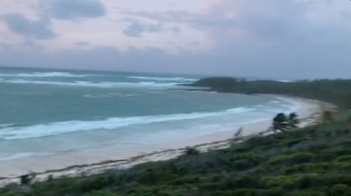
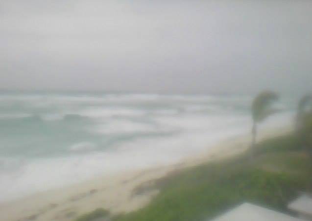
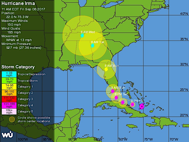
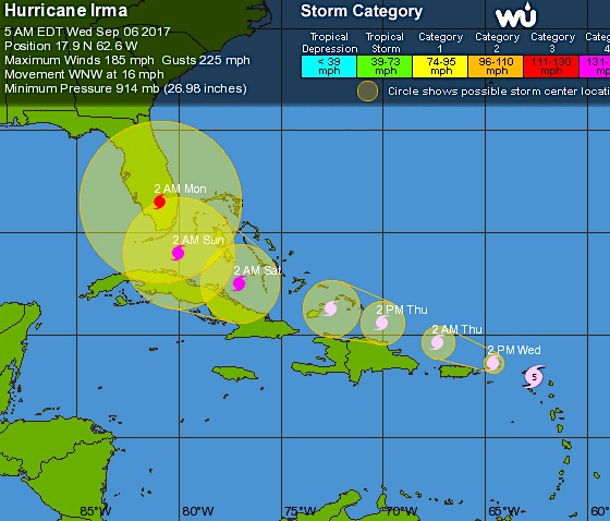
Hurricane Irma barrels on northwards as Florida begins to count the cost.  Abaco has had its turn to experience the awesome power of this brute of a storm. Or make that turns (plural) because such a massive storm 400 miles across, spiralling longs strands of filthy weather outwards with centrifugal menace, can strike more than once as the main storm passes further off.

Hurricane Irma, Abaco

Thanks to the relatively late shift of the storm’s path to the west, there was no direct hit on Abaco (as was once forecast). High winds and heavy seas, but none of the cruel devastation elsewhere that we have all been watching and reading about with horror and sympathy for the victims.

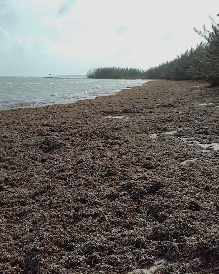
Seaweed covering the beach at Casuarina, AbacoHurricane Irma, Abaco

By Saturday evening, relieved messages were already being posted. Later, an official statement confirmed limited harm and damage. The airport was reopened. Albury’s Ferries announced the forthcoming resumption of services. Gradually, the overall picture took shape as more reports and messages came in from the mainland and the cays.

Tahiti Beach, Elbow Cay, Abaco

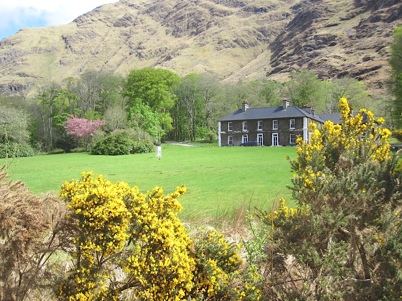
At Delphi, Jason confirmed that the worst of the storm passed quite quickly and that there was no structural damage, though doubtless the gardens have taken a beating – a minuscule inconvenience comparatively.

Hurricane Irma, Abaco    Hurricane Irma, AbacoHurricane Irma, Abaco

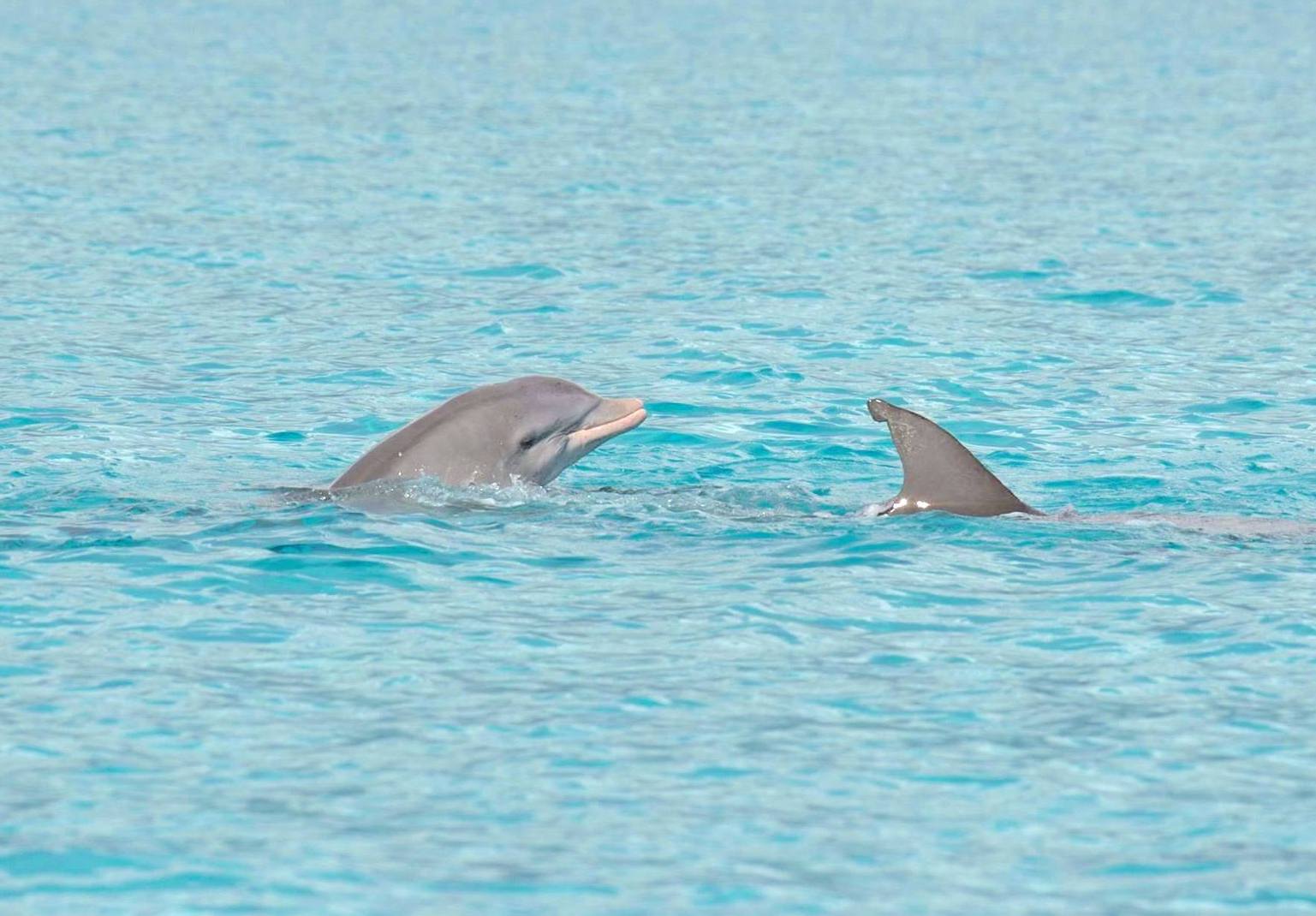
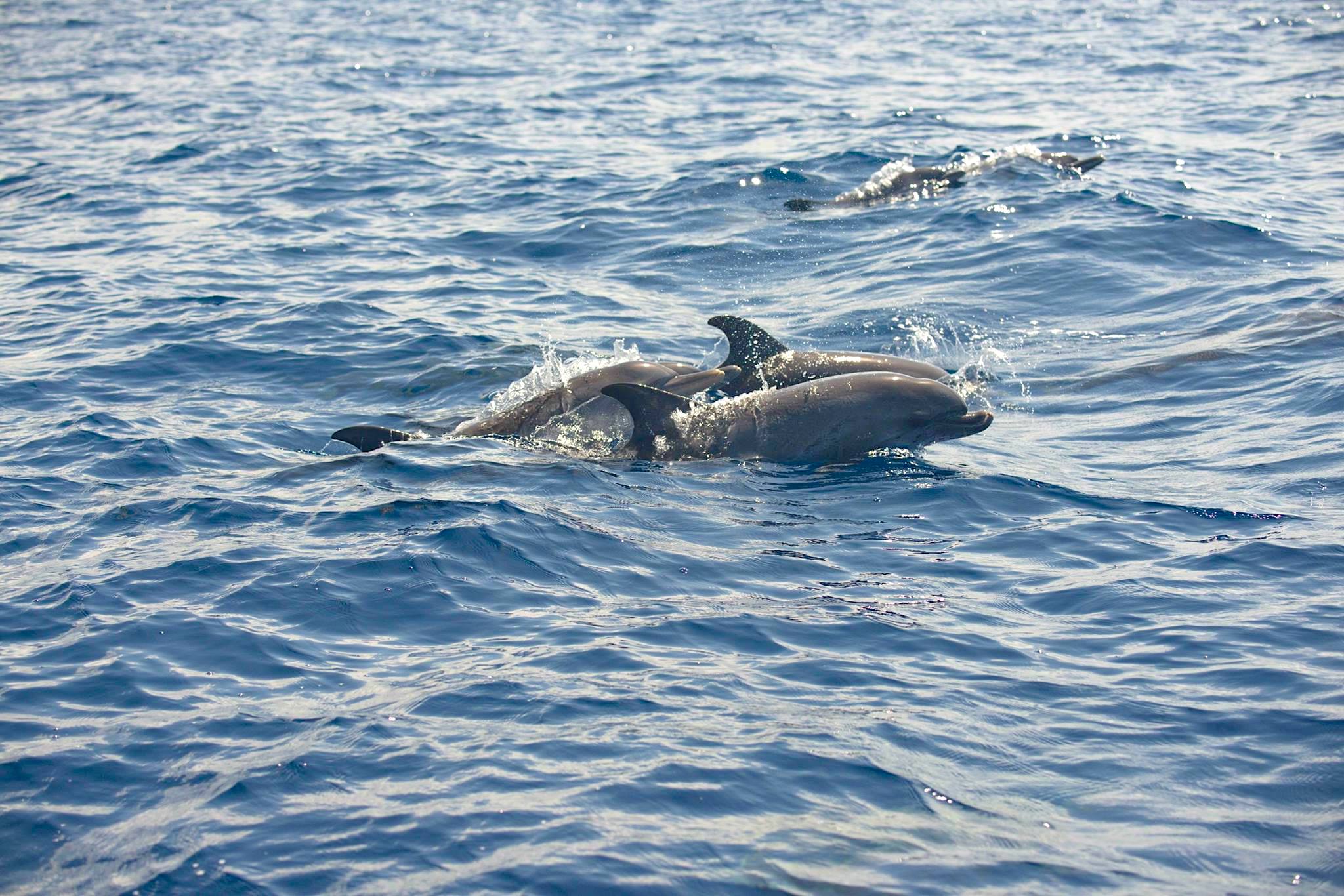
By yesterday morning, the only area I hadn’t seen anything about was the west side of Abaco – Sandy Point. Might things have been different -perhaps worse –  on the west coast? Then I heard from BMMRO HQ that the situation was much as elsewhere. The whales and dolphins of the Bahamas will continue be researched when the boat can put out to sea…

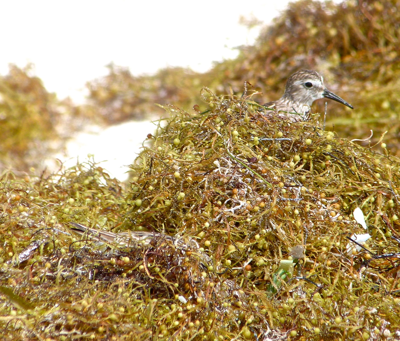
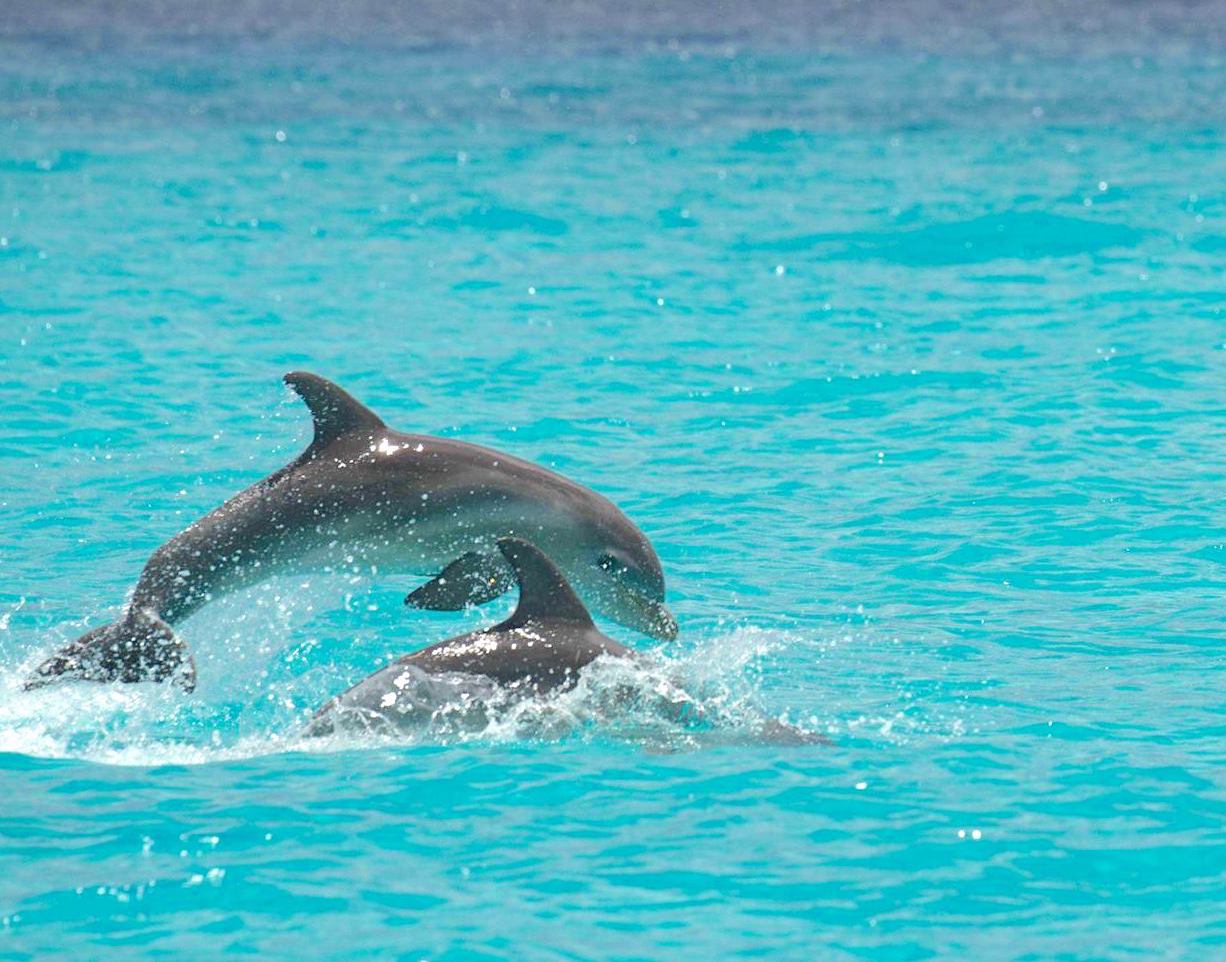
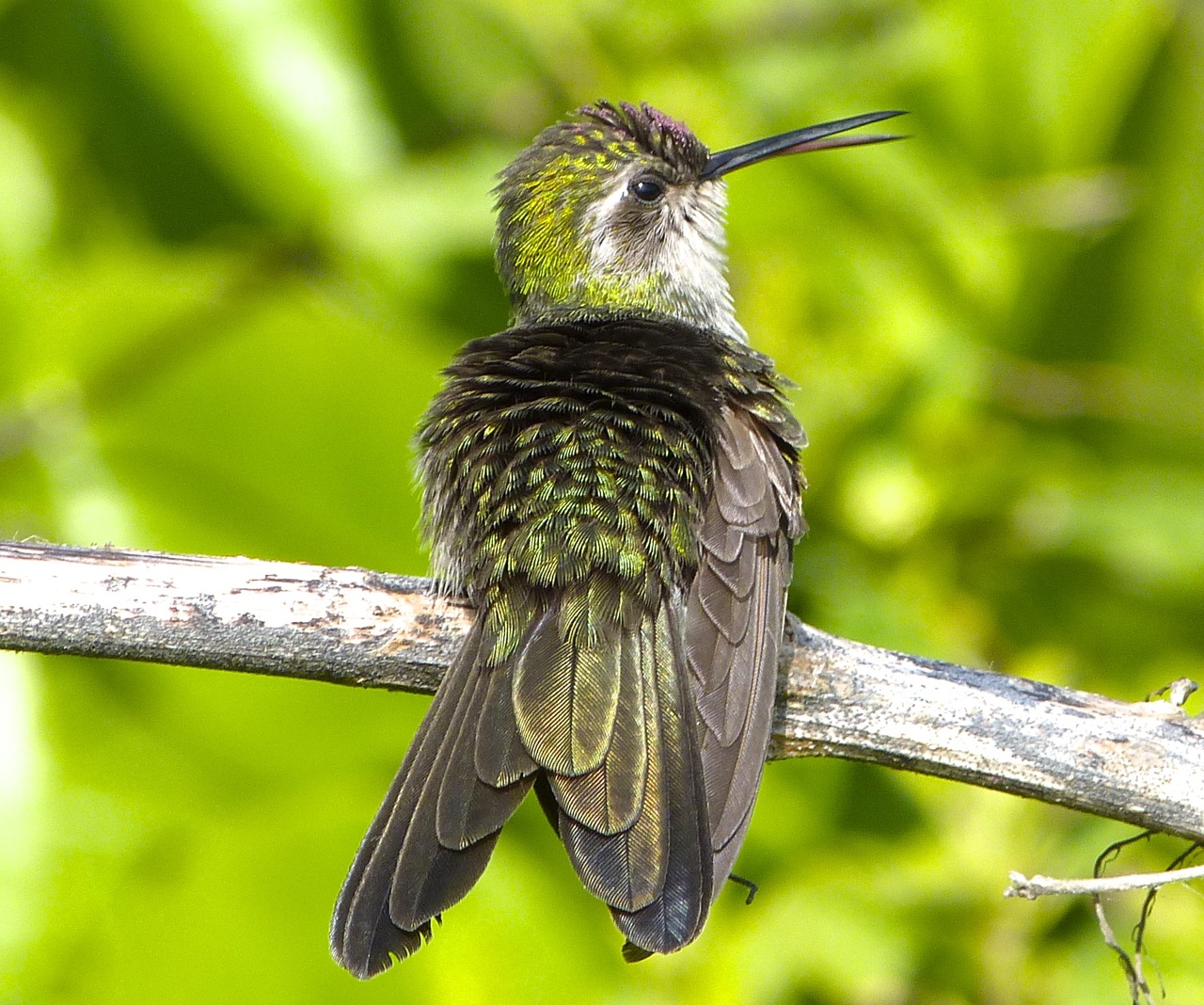
Atlantic Spotted Dolphins seen off Abaco before Irma came alongAtlantic Spotted Dolphins, Abaco, Bahamas (BMMRO)

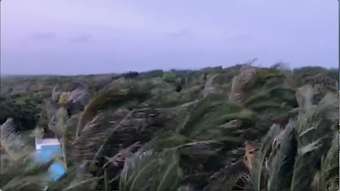
Like the aftershocks of an earthquake, bouts of high winds and huge gusts have continued to pass over; and in places the sea has been sucked out from the beaches. There have been outages of course (not a novel experience even in calm times); and I’ve seen reports of interruption with water supplies. But I think it can be said that Abaco has escaped quite lightly – and certainly in comparison with the terrible devastation elsewhere.

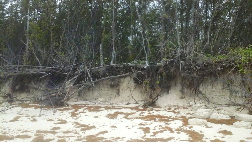
Roof tiles have been lost, but there seems to have been limited structural damage. Trees have been trashed of course, and there has been plenty of beach erosion. Many beaches have been smothered in seaweed. But all-in-all, Abaco has fared alright, which is not to say that people’s thoughts have been absent from those who have taken the hit and borne the brunt of Irma’s rage.

Bahama Palm Shores, Abaco

The Low Place, Man-o-War Cay

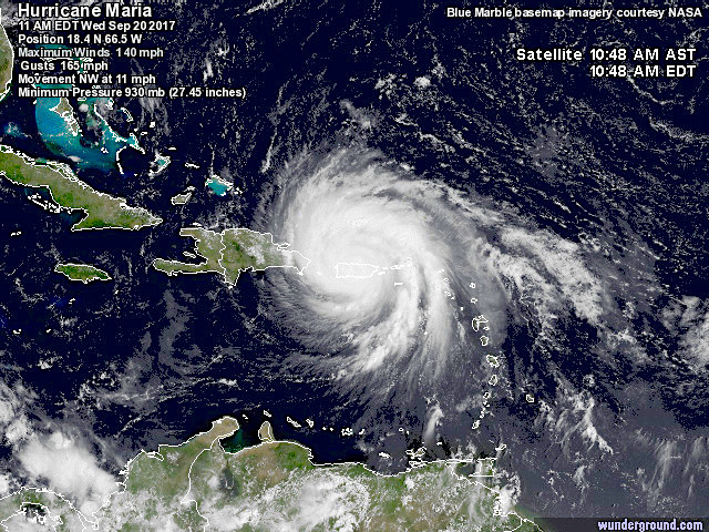
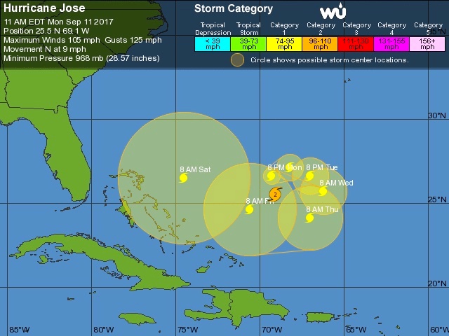
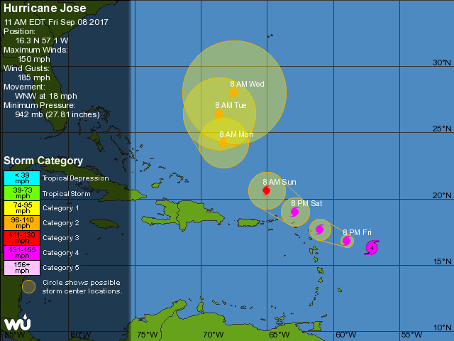
WHAT ABOUT HURRICANE JOSE?

The tracking for this pursuer of Irma has appeared to show the storm going round in circles in mid-Atlantic. Until quite recently. This morning’s prediction shows a determined move to the west towards the end of the week. One to keep a very close eye on still.

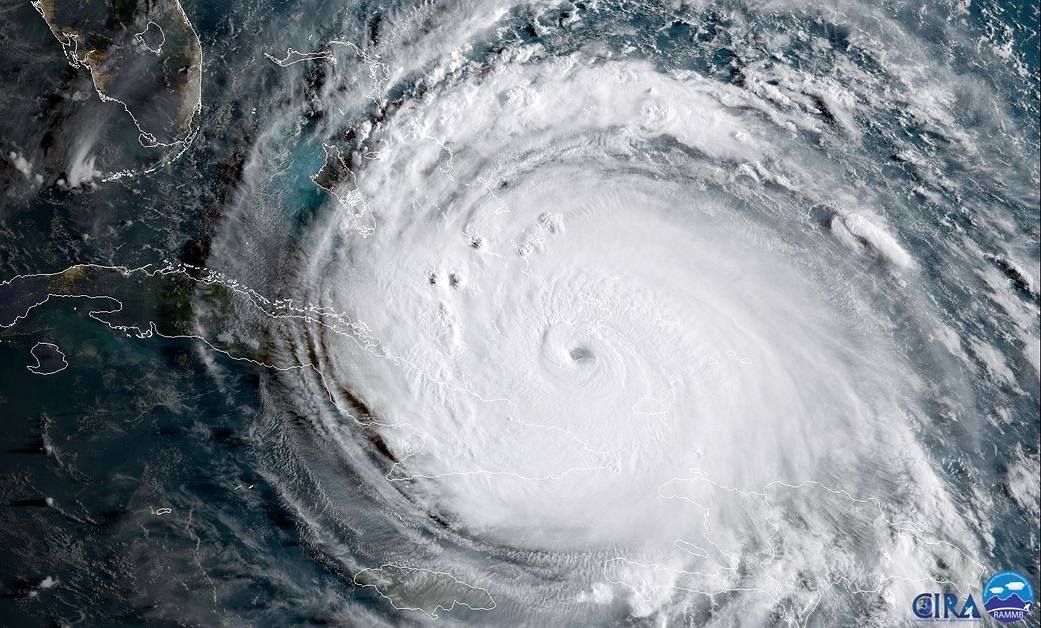
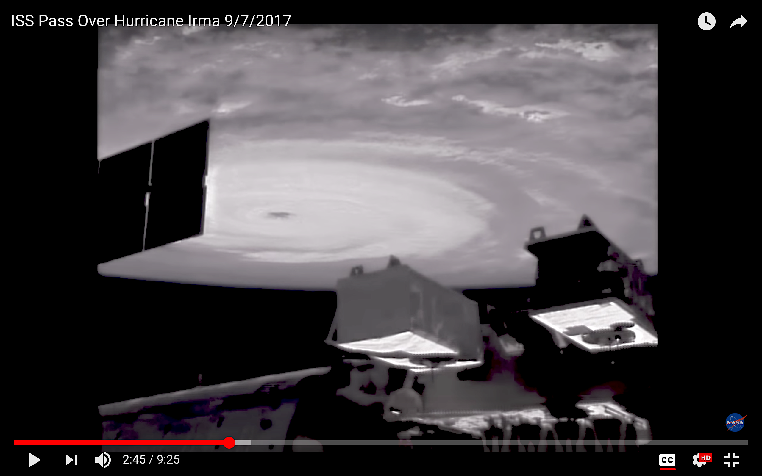
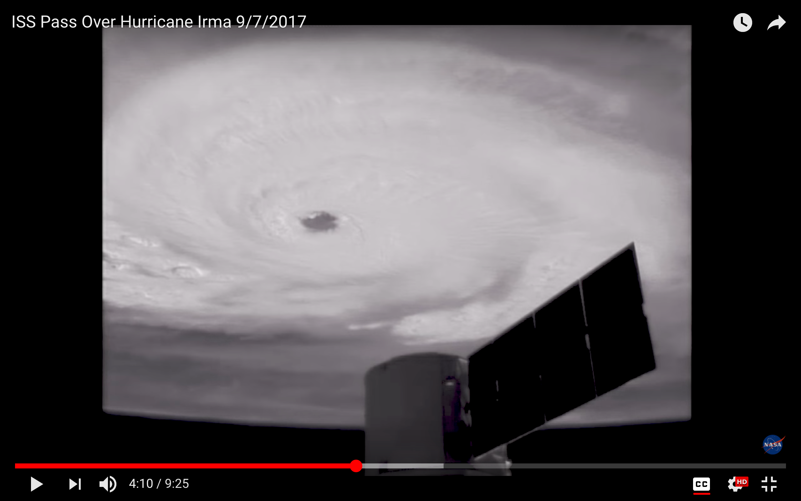
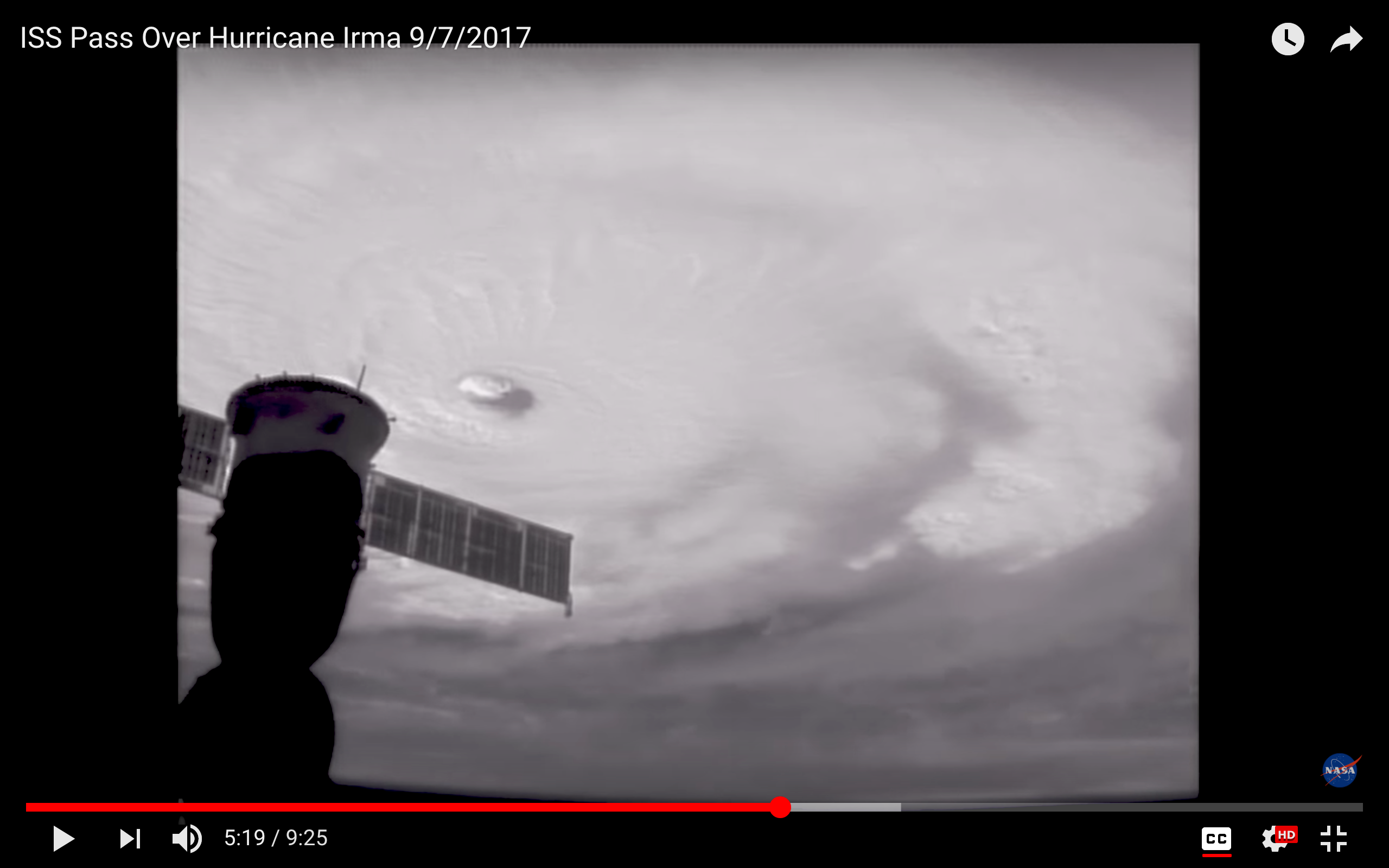
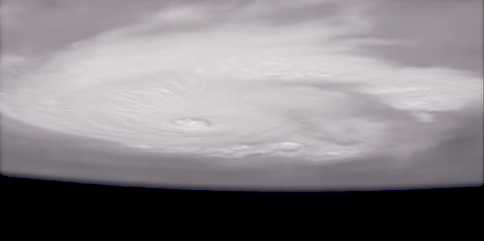
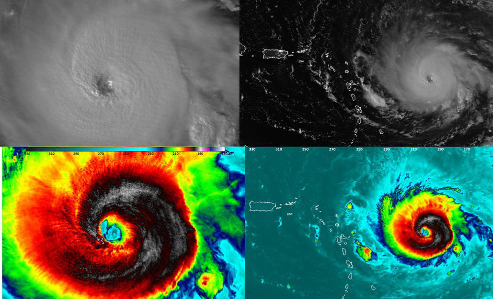
WHAT ARE THE VIEWS FROM SPACE RIGHT NOW?

NASA-NOAA’s Suomi NPP satellite: night-time view of Irma over Florida

NASA / GOES East satellite: daytime view of the storm moving north over Florida

Credits: Karen Eldon (1); Olivia Patterson Maura (2, 9, 10); Andrea Janeen Sands Albury (3); Abaco Buzz (4); Jason Prangnall (5, 6); Dive Abaco (7); BMMRO (8); Beth Nace (11, 12, 13); Charmaine Albury (14); Wunderground for the Jose Tracker; NASA / NOAA / GOES for the space shots 

Unknown's avatar

HURRICANE IRMA UPDATE (2): ABACO, BAHAMAS 9/9


Hurricane Irma NASA

HURRICANE IRMA UPDATE (2): ABACO, BAHAMAS 9/9

It’s Saturday afternoon. Irma has (surprisingly?) weakened from Cat 5 overnight to Cat 3 right now – but is expected to regain Cat 4 strength as the core of the storm reaches the tip of Florida. The hurricane has now cleared the north coast of Cuba and is heading for Florida, where the first effects of this massive storm are already being felt.

For Abaco, the situation is better than feared and expected at one stage. I’ve seen several reports from the main island, including a video from Jason who is holding the fort at Delphi. He’s also sent a video sweep of Rolling Harbour taken from the verandah of the club a couple of hours ago.


Here are a couple of photos from Olivia Patterson Maura taken from her stretch of beach, taken earlier today. It hasn’t taken long for the sea to build up from rough to scary.

Below are some trackers and screenshots, mostly issued at 11.00 am today. The top one segues into a path prediction. I think it’s now certain that for Abaco, at least, the hurricane will be more of a violent sideswipe than a critical event. Not so elsewhere, for sure.

WHAT NEWS OF JOSÉ AND KATIA?

It looks as though JOSÉ will continue north-west, with an increasing hook to the east over open water. A complete change of course obviously remains a possibility, but for the moment it retains the status of ‘one to watch’. KATIA has dissipated, and although there are remnants of the storm

Credits: NASA (1, 5, 7);  live tracker screenshot NotableMedia (2);Olivia Patterson Maura (3, 4); Wunderground (6); NOAA (8); Video Jason Pragnall. Stay safe.

Unknown's avatar

HURRICANE IRMA TRACKING UPDATE: ABACO, BAHAMAS 9/9


HURRICANE IRMA TRACKING UPDATE: ABACO, BAHAMAS 9/9

It’s Saturday morning and Irma has strengthened to Cat 5 overnight as she barrels along the top of Cuba. I won’t waste words: you have better things to do than read blogs. Instead, here are some overnight tracking reports, each informative in its own way. Please note that these are a few hours old and already things will have progressed further (not least where Cat 4 is still shown). The amazing header image is from 9/7, and shows the awesome majesty of extreme weather seen from space…

Credits: NOAA with props to Randy Bresnik / AstroKomrade (1);  live tracker screenshot NotableMedia (2); Wundergroung (3, 4); NASA & partners (5). Stay safe

Unknown's avatar

HURRICANE IRMA UPDATE & ISS VIEWS: ABACO, BAHAMAS


HURRICANE IRMA UPDATE: ABACO, BAHAMAS

It’s Friday afternoon. Irma is spinning her destructive progress through the Bahamas towards… well, right at the moment it seems to be Andros and then towards the Florida coast and northwards up the panhandle. Abaco is not currently shown in the direct firing line – but there’s no doubt that the passage of such a massive storm will mean plenty of dirty weather very soon now. 

I have just taken a screenshot (above) of the live tracker I am using. Top right is a realtime satellite view of Irma’s current position. Bottom left is the predicted position later this weekend. The fiercest part of the storm will have passed over Andros and carried on northwest, a path further west of Abaco than recently forecast. We must hope so, remembering of course that one location’s dodged bullet will inevitably be another’s bullseye.

In the tracker realtime shot above, it’s impossible to ignore the lurking menace of Hurricane Jose – recently graded Cat 4 – to the east. Here’s the latest Jose tracker I can find for today. Right now (but who knows for how long) this system looks as though it may hook north and expend its savage energy in the open ocean.

And here is the latest Irma tracker, as I write. It looks as if the storm may dissipate after it has made landfall at the southern tip of Florida, but it will clearly be very unpleasant down there I’m afraid.

There’s been some interest in the International Space Station ISS images I posted yesterday. The serenity of the view of a hurricane topside is so at odds with the ferocity of the weather beneath and the destruction being wrought on the ground. And they work on the imagination: suppose you were in that capsule, moving with eerie calmness through the sky, looking at the swirling mass of white cloud far below…?

Today’s screenshots were taken during yesterday’s ISS pass over Irma, using external cameras. The one below is the last in the sequence, an upside-down view looking rather like some pale alien spaceship hanging above a dark earth.

I’ll be watching events during the weekend. By the time I next write, the storm will have passed the Bahamas, and the assessments will have begun. From a safe distance of 4250 miles, I will be thinking of those who are already counting the cost; those currently enduring the brutality; and those still awaiting Irma’s malice.

THE EVIL EYE

Credits: all images ISS / NASA; live tracker from NotableMedia; tracker images for Jose & Irma from Wunderground

Unknown's avatar

HURRICANE IRMA: THE STRANGE BEAUTY UNLEASHING CRUEL SAVAGERY


HURRICANE IRMA: THE STRANGE BEAUTY UNLEASHING CRUEL SAVAGERY

Hurricane Irma is carving her destructive path through the northern Caribbean. As the storm moves relentlessly on towards the Bahamas, speculation has already started whether Irma may be the first hurricane to be classified as a Cat 6 – or the last huge Cat 5 before the new category is introduced.

The standard SAFFIR-SIMPSON SCALE only goes up to 5. But for exceptional storms with wind speeds exceeding a suggested 180 mph (and these are increasing worldwide), it is becoming clear that re-categorisation is called for. As with luxury hotels, 5 stars has become inadequate to describe the magnitude**.

There’s nothing to be gained from showing images of the havoc and misery already caused by Irma. TV media, print media and social media are covering that base more than adequately. So instead let’s look at the other side of the hurricane as the serene white cloud mass whirls inexorably westwards – the view from the International Space Station ISS.

THE EVIL EYE

The NASA site is a treasure trove of wonderful images, many of which can be downloaded. Here are a few of these, taken over the last 48 hours. There’s an extraordinary video of an ISS pass over Irma yesterday, and I have taken a few screenshots from it for those who may not have the time right now to watch the footage.

ISS PASSES OVER HURRICANE IRMA 9/6/2017 (10 mins)

Finally, here is a link to a live tracker that I have already posted on my FB page. This amazing resource shows vital information in 3 ways: a realtime view of Irma’s current position; the future tracking over the next few days; and realtime notes. As far as I can make out, the main image modelling means that the predicted path changes seamlessly as the storm progresses. It may be the most useful tool for Abaco / Bahamas predictions right now, because you won’t need to keep checking NOAA, Wunderground, Accuweather and the rest to look at the ‘cone’ movements. Just tune in to this. If you do, I’d be interested to hear how helpful people think it is. I’m testing it too and comparing it with other sources.

**Frankly I’d be as likely to want to be in a 6-star hotel as in a Cat 6 storm. Which is to say, not at all

NASA-NOAA’s Suomi NPP satellite flew over Irma at 1:54 a.m. AST Sept. 5, 2017, when it was still a Category 4 hurricane. Night-time images showed a well-defined eye with convection most of the way around it. Both the infrared and Day-Night Band both show tropospheric gravity waves. Think of them the waves generated if you dropped a rock into a pond, but in this case it is convection punching upward.
Credits: NASA/NOAA/UWM/CIMSS/William Straka III

Credits: main photos & space station footage: ISS / NASA; Live tracker from NotableMedia; collage NASA / NOAA & as credited

Unknown's avatar

WORLD SHOREBIRDS DAY, PIPING PLOVERS & IRMA


Piping Plover (Danny Sauvageau)

WORLD SHOREBIRDS DAY, PIPING PLOVERS & IRMA

Sept 6 2017. World Shorebirds Day dawns, even as the huge Cat 5 Hurricane Irma makes landfall over the small islands of the eastern Caribbean. Irma’s path has been relentlessly westwards, for sure – but the path has been unnervingly variable. The tracking reports showed Abaco successively as being in line for a direct hit; then taking a sideswipe from the south; then completely clear of the cone prediction; then within the northern edge… and today, a right hook to the east suggests again that Abaco will take a hit from irma (though as a predicted Cat 4 or maybe 3).

Hurricane Irma Tracking Path Sept 6th 2017 Wunderground

Far down the list of concerns in such a situation come shorebirds. Most if not all the islands that Irma will affect have wonderful shorebirds, both permanent and migratory. On Abaco my personal preoccupation is for the tiny Piping Plovers and our citizen scientist annual 6-month WATCH. Generally, the birds manage to find some cover at the back of the beaches to hunker down until the worst is past. But generally the beach populations are rather different after the storm, as birds scatter and take cover. 

Well, except this little guy who decided to take a windy bath on the Long Dock at Cherokee during Hurricane Matthew as it passed over Abaco last October (and props to Keith Kemp for braving the elements to get this shot!)

Birds are resilient and resourceful. Humans too. But nature unleashed with full force is a terrifying prospect. From a safe distance of 4250 miles from Marsh Harbour, thoughts and best wishes from Rolling Harbour will be with all those in the path of Irma over the next few days. 

Piping plovers on the Delphi Beach, at a more peaceful timePiping Plover, Delphi, Abaco (Keith Salvesen)

Photos: Danny Sauvageau, Keith Kemp, Keith Salvesen / Rolling Harbour; Graphic by Wunderground

Unknown's avatar

DOUBLE DELPHI: TWICE THE CRAIC, TWICE THE KALIK


Double Delphi by Peter Mantle

DOUBLE DELPHI: TWICE THE CRAIC, TWICE THE KALIK

For some years those who know Peter Mantle have been willing him to write about his two very different Delphis: East (Co. Mayo Ireland) and West (Abaco, Bahamas). It is often said that ‘everyone has a book in them’, but most are without lively and engaging material to work with, or a talent for writing in the first place.  Peter has plenty of these assets: great stories to tell and the writing skills to bring them alive. I’m not being paid for a creepy encomium, but I’ve read ‘Double Delphi’ in its various iterations during the winding road to publication (it has been a prominent feature at Rolling Harbour Towers during production). It’s exactly what we all hoped for!

Double Delphi by Peter Mantle

I don’t want to issue ‘spoiler alerts’, and I’m not proposing to provide a cheery synopsis of Peter’s book. For all those who have loved Delphi Lodge in Ireland; for all those who have loved the Caribbean twist to the Delphi experience on Abaco; for all those who love fishing; and for all those who have admired Peter for his astonishing creation of two fabulous fishing establishments over 35 years – this book is for you. Sandy Leventon, well-known former editor of the indispensable Trout & Salmon Magazine has read the book: his views are on the back cover.

Double Delphi by Peter Mantle

Double Delphi contains plenty of incident. There are fishy tales of course; some people great and good; some perhaps less so; a gold rush; legal drama; financial drama; conflict and personality ‘mis-alignments’; and in amongst it all, hard work, success, craic and good times as Peter bestrides the Atlantic with his ambitious twin piscine projects. There seems to be a lot of whiskey along the way, too.

DELPHI LODGE IN 2011, RESTORED TO ITS FORMER GRANDEURDelphi Lodge, Co. Mayo, Ireland (Keith Salvesen)

Many readers will head straight to the index at the back of the book, looking eagerly to see if their own roles in the Delphi sagas have been recorded. They will be disappointed: there isn’t an index! But the chapter headings are promising, and include Of Lice & Men; Princes & Papers; Stars & Gripes; and Bahamian Rhapsody. And there are two sections with plenty of photographs (many historic) to enjoy – two examples shown below.

DELPHI (WEST) ON ABACO – ‘SOMEWHERE IN THE MIDDLE OF NOWHERE’Delphi Club, Abaco, Bahamas (Keith Salvesen)

PM’S FIRST DELPHI SALMON 1986

Double Delphi is imminently to be launched, and can easily be bought right now by clicking this linkhttps://wallopbooks.com/order-form/  (there’s some more blurb there too).

A YOUTHFUL PETER CONTEMPLATES THE FUTURE

All photos: KS / Rolling Harbour except B&W x 2 from the book

Unknown's avatar

BLACK-FACED GRASSQUITS: FEEDING TIME


Black-faced Grassquits: feeding time (Charles Skinner)

BLACK-FACED GRASSQUITS: FEEDING TIME…

Not a feeding frenzy exactly, but persistence pays off. However, this little bird found that dad had eventually had enough of the nurturing bit…

URGENT – feed meeeeeeeeeeBlack-faced Grassquits: feeding time (Charles Skinner)

[*THINKS* can’t reply, I’ve got my mouth full…]

The good-thing hand-over

No! You’ve had quite enough for one snack…

Feeding sequence by Charlie Skinner.

*No birds were hurt -not even their pride or dignity – in the photographing of this heavily anthropomorphised sequence…*


Unknown's avatar

BAHAMAS REEF FISH (38): SPOTFIN BUTTERFLYFISH


Spotfin Butterflyfish, Bahamas (Melinda Riger / G B Scuba)

BAHAMAS REEF FISH (38): SPOTFIN BUTTERFLYFISH

Butterflyfishes are a large family of mainly colourful small fish somewhat like mini-angelfish. The spotfin butterflyfish (Chaetodon ocellatus) is one of several types of butterflyfish found in the western Atlantic Ocean; and one of half a dozen or so you are likely to see nosing around the coral reefs of the Bahamas.

Spotfin Butterflyfish, Bahamas (Melinda Riger / G B Scuba)

The name ‘spotfin’ derives from the dark spot on the dorsal fin. At the front end, there is a distinctive black vertical stripe that passes right through the eye. Combined with the vivid colouring, predators are in theory confused or warned off.  The spotfin’s superpower (on a modest scale) is that at night, a change of appearance occurs in adults. The dark patch on the dorsal fin increases in size, and dark bands appear on the body. This seems to be in order to provide further protection during the darker hours.

Spotfin Butterflyfish, Bahamas (Melinda Riger / G B Scuba)

The spotfin above has an isopod attached to it, a type of crustacean with a segmented body. Primitive fossils of these creatures have been dated back some 3m years. Want to know want this one is up to? These things “are mostly external parasites of fish or crustaceans and feed on blood, having piercing and sucking mouthparts and clawed limbs adapted for clinging onto their hosts”.

Soldierfish photobombs a spotfin. Or maybe it’s vice versa?Parasitic species are mostly external parasites of fish or crustaceans and feed on blood. The larvae of the Gnathiidae family and adult cymothoidids have piercing and sucking mouthparts and clawed limbs adapted for clinging onto their hosts.

Reading about this particular species of  butterfly fish, I discovered that the spotfin “is very common and very hard to maintain in a tank” –  as if the two facts are somehow connected. So might they be coarse or vulgar, and thus unsuitable companions for better bred and perhaps sensitive aquarium fish? As it turns out, it may be because they are vulnerable to predation, and so can coexist only with peaceable tank friends. 

Spotfins are perfectly happy swimming upside down; and their party trick apparently is to rise to the surface and squirt a jet of water in the air. Sadly, I couldn’t come up with a photo of this…

RELATED POSTS

LONGSNOUT BUTTERFLYFISH

REEF BUTTERFLYFISH

Credits: All fab photos by Melinda Riger / Grand Bahamas Scuba

Unknown's avatar

Viewing the Solar Eclipse from the Bahamas


TOTAL ECLIPSE ON MONDAY? 80% FOR ABACO!

and how to view it safely…

π Amanda Diedrick, companion Abaco blogger at Little House by the Ferry, GTC

Abaco Sun (Amanda)'s avatarOLD Little House by the Ferry

Though the Bahamas is not within the path of totality of this Monday’s solar eclipse, we’ll still be able to view this amazing phenomenon from the islands.

How to View the Solar Eclipse from the Bahamas Solar Eclipse by Ashwin Kumar (Bangalore, India)

View original post 259 more words