Unknown's avatar

MOUNT ABACO: THE ISLAND’S MAJESTIC SUMMIT (134 feet)


Matterhorn from Domhütte - 2.jpg

MOUNT ABACO: THE ISLAND’S MAJESTIC SUMMIT (134 feet)

The header photograph is not in fact anything to do with Abaco. Apologies for any confusion. It’s the Matterhorn, towering over the border of Switzerland and Italy, complete with high altitude, year-round snow and sub-zero temperatures. Abaco has its own excellent skiing, of course, but solely of the watery sort. However, recently the question arose as to exactly where the highest point on Abaco is situated. All sources agree that the altitude is a dizzying 134 feet, with some equating that with 40 meters and others with 41. It would be nit-picking to use the straight conversion of 40.8432 meters.

I once did a post comparing the altitude of Abaco with Mount Everest – if you have the patience, you’ll find it HERE. A check on G@@gle throws up a fascinating site called PEAKBAGGER. Click on the link and it takes you to the Abaco entry; but elsewhere on the site there is a mass of remarkable worldwide altitude information that you could easily spend an hour or 2 investigating. The essential info for Abaco is this:

  • Elevation: 41 meters, 134 feet
  • Name: “Unnamed High Point”
  • Latitude/Longitude: 26° 34′ 6” N; 77° 8′ 14” W 26.568399, -77.137319
  • 3rd highest point in the Bahamas
  • 54th highest point in the Caribbean
  • 1014th highest island point in the world (which seems very unlikely, somehow)
  • Nearest high point is on Eleuthera
  • No ‘ascents’ by registered ‘Peakbaggers’ (this is now on my bucket-list for easy personal achievements)

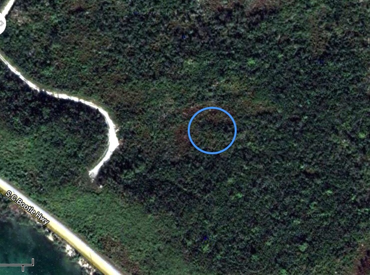
Peakbagger’s map places the high point close to the Highway north of Marsh Harbour. This puzzled me, partly because I remember Ricky Johnson showing us a significant rocky outcrop deep in the pine forest of south Abaco. Also, the land relief shown on the Peakbagger map suggests a higher ridge to the north-west of the red circle.Abaco High Point Map 1

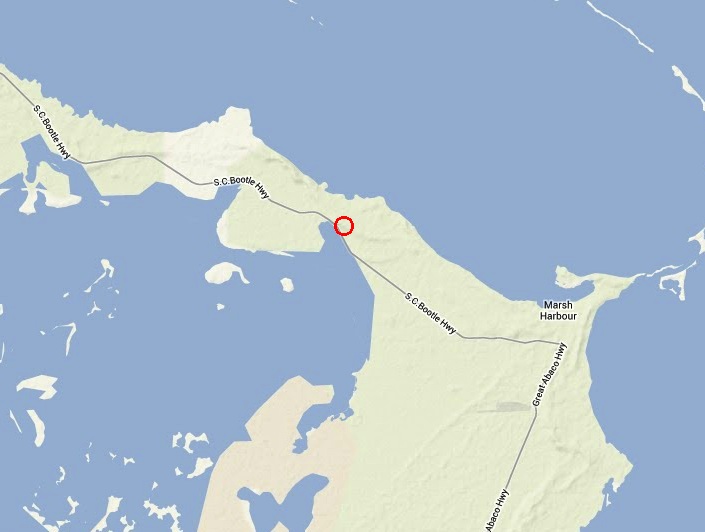
So I did what any Abaco researcher would do – I contacted Sandy Estabrook, éminence grise behind the wonderful ABACO ESCAPE website. Within a very short time he got back to me with a clipping from a nautical map, confirming the high point’s location as the one given by Peakbagger. Abaco Nautical Chart

Far more importantly, it turned out that Sandy actually ascended the summit in 2009 with a friend and without oxygen. His expedition journal states simply “Heading South along Queens Hwy, Frank pointed out a hill on the Sea of Abaco side of the road. It had quite some elevation of over a hundred feet or more it seemed. (I have not seen a higher place in all of Abaco). And atop the hill was a tower that I was told was built by real estate interests some years ago for prospective clients to view the surroundings. We climbed the tower and I took a couple picts”

The tower will be familiar to travellers passing by on the Highway. I had read that this was a good place to look out for birds, and had assumed it was some sort of fire-watching tower. The use of a tower to scope out land for development is an ingenious one, but the landscape is mercifully still undeveloped. Here are some photos from the vantage point.

View roughly south-east from the tower to Hope Town. The lighthouse is just visible to the right.Frank View from Tower 84 copy

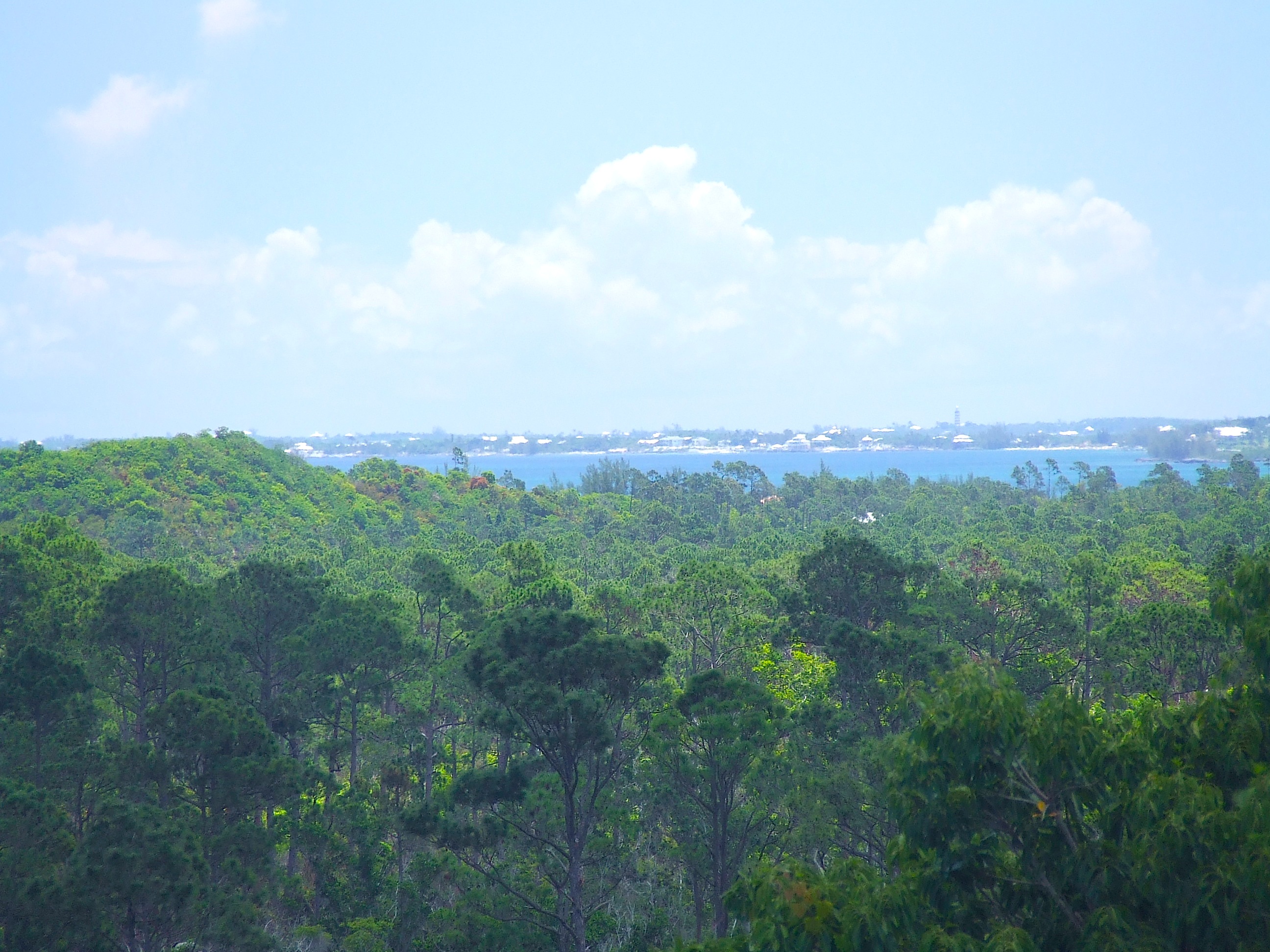
Looking north-east, with Great Guana Cay just visible on the horizonFrank View from Tower 82 copy

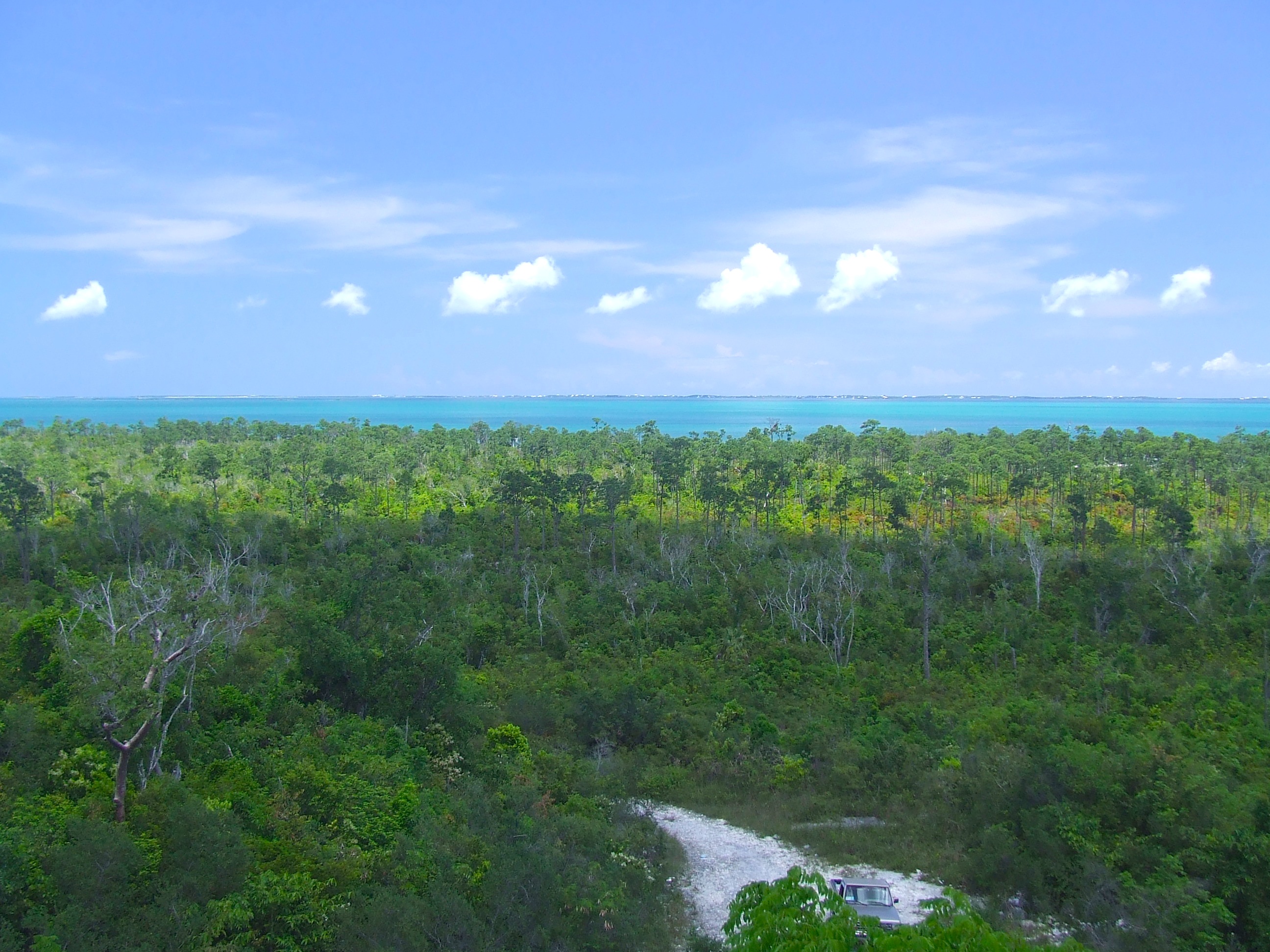
The view north(ish) along the ridge, with the Highway snaking up to Treasure CayFrank View from Tower 83 copy

AERIAL VIEWSMount Abaco 5 copyMount Abaco 3 copy

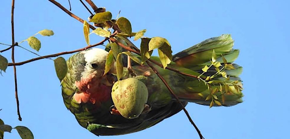
Normally, high points acquire a name at some time. Even quite low ones. Perhaps Abaco’s high point deserves one. In which case, Parrot Peak? (But the parrots, while symbolic of the island, don’t frequent the area). Hummingbird Hill? (Tiny and perfectly formed). A134? (Uninspiring). All suggestions welcome…

STOP PRESS Within 24 hours, John Bethel has kindly to say “I have always known this hill to be called Pidgeon Hill”. So, it has a name already. I’ll try to find out some more about this – for example whether the name is historic or recent. Can anyone add anything to this?

Thanks to Sandy Estabrook and to Peakbagger

 Abaco Escape logoPeakbagger Logo

Unknown's avatar

‘HEY JUDE! DON’T MAKE IT BAD…’ A HURRICANE HITS THE UK


Storm Jude Newhaven Lighthouse

‘HEY JUDE! DON’T MAKE IT BAD…’ A HURRICANE HITS THE UK

Today is the Feast of St Jude. Patron Saint of lost causes and (more modernly) depression… and, some suggest, IBISES.

It is also the day of the most violent storm to hit the UK since 1987, with hurricane force winds recorded on the south coast (Force 12 on the BEAUFORT SCALE) and plenty of Force 11 ‘violent storm’ readings. There has been widespread damage to trees, cars and property, with 2 deaths so far reported, and one person missing at sea. Public transport is returning to normal, after the wholesale cancelation of flights, trains and other public transport services. 300,000 homes have had power outages. I fully realise that Abaconians have far more frequent and far worse hurricanes visited on them, the latest being Sandy last year and Irene the previous year. This is in no way a competition, but I thought some images from the UK over the last 24 hours or so might be of interest and dispel the notion that Britain is a country of benign 365/24/7 soft drizzle and gentle rain…

Brighton Pier, Sussexbrighton_2715167k

In 1987 a popular BBC weatherman had the misfortune to say on air “Earlier on today, apparently, a woman rang the BBC and said she heard there was a hurricane on the way… well, if you’re watching, don’t worry, there isn’t!”. That evening, the worst storm to hit South East England for three centuries caused record damage and killed 19 people. In contrast, the weather agencies were ahead of the game on this occasion, so Britain was well-prepared for the onslaught…

131025jet              131025winds2

The storm looms over the Dorset and Sussex coasts…Storm Jude massing off Dorset coastStorm Jude

The whole length of the south coast takes a hit, from Cornwall to KentImage 1Britain Stormstorm-weather-mari_2715597kstorm-boat-weather_2715542kNew England Makes Preparations For Hurricane Sandy ImpactStorm Jude Newhaven Lighthouse 2readers-storm-port_2715656k

And the coast of WalesStorm Jude Wales

Inland, there is damage to building and property. This crane fell onto a Government building in LondonStorm Jude collapsed crane, London_70749840_786671a0-9df9-45da-9066-6f73bb46e830 readers-storm-11_2715776k

A large number of trees have fallen, many onto cars in residential areasstorm-weather-tree_2715589k ad_119148649 readers-storm-tree_2715620k

Schools have not been closed, but some pupils needed to take an unorthodox route_70748775_81e1d53b-f22c-4738-9929-6389dac477e7 readers-storm-10_2715781k

More minor incidents involved some garden trashing – dammit, that’s our garden…Image 2

These 2 photos were taken on the Chesil Beach in Dorset, where Mrs Harbour and I were a couple of weeks ago, and which I posted about on my companion non-Abaco blog HERE. Below them is a photo of the same location I took then, for comparison.

Storm Jude Chesil BeachStorm Jude Chesil Beach 2chesil-bank-6

The highest wind velocity, around 100 MPH, was recorded at the Needles, a well-known geographical landmark on  the west side of the Isle of Wight in the English Channel. Here is a photo I took there a year ago, when things were calmer. The Needles, Isle of Wight

NEW PHOTOGRAPHS FROM CORNWALL CAN BE FOUND AT STORMY MONDAY (to continue the musical theme)

Saint Jude, St Peter’s Rome

CREDITS Many & various: news agencies; BBC; folk who have uploaded their pics onto news sites, both national & local, for wider viewing; anyone not covered by the aforementioned...

Unknown's avatar

ABACO’S RAREST VISITOR: MEET ALBERT ROSS… THE ALBATROSS


ABACO’S RAREST VISITOR: MEET ALBERT ROSS… THE ALBATROSS

I can find no record for the sighting of an albatross in the waters around Abaco. Nor for anywhere else in the Bahamas for that matter. It must have come as some surprise to the BMMRO team out at sea on their research vessel off Sandy Point to see a large and unusual seabird bobbing tranquilly on the water. A black-browed albatross Thalassarche melanophrys. Diane Claridge managed to get a great shot of it and I’m really pleased to be able to use it here.

Black-browed Albatross, Abaco © DC BMMROBlack-browed albatross off Sandy Point, Abaco, Bahamas. Photographed by Diane Claridge.

© Bahamas Marine Mammal Research Organisation 2013

This bird was way out of the normal range for the species. They are birds of the southern oceans, breeding in colonies on such islands as the Falklands, South Georgia and Macquarie Island. As far as I can make out, they have no business to be north of the equator at all.

Black-browed Albatross Range Map BirdLife Int

SIGHTING A BLACK-BROWED ALBATROSS: A REPORT

During a three-hour survey for whales off Sandy Point, Abaco on Sunday, July 21st scientists from the Bahamas Marine Mammal Research Organisation had an exceptional sighting. Dr Diane Claridge, the group’s Executive Director recalls details of the sighting:

“We were drifting waiting for a beaked whale to resurface when our intern Tristan Albury pointed towards a white object floating in the distance and asked what it was. We decided that it was a piece of trash, unfortunately a common sighting, and continued to focus our search for the whale. A half hour later, we still had not re-sighted the whale and believed that it may have gone down on one of its one-hour long feeding dives. So with time to kill and the “trash” still in sight, we had another look with binoculars. We realised immediately that it was a very large bird and slowly motored towards it for a closer look. I began taking photographs of it because we already knew it was unusual and we wanted to be sure to identify the species. As we got closer, Roxy Corbett, a visiting scientist and avid birder exclaimed that it was an albatross! I couldn’t believe it. We were able to approach within 100 feet at which point it swam towards us providing an opportunity for us to document its body condition; it appeared healthy with no obvious signs of distress.

Later when back ashore, we compared our photographs with those available online and learned that it was a juvenile Black-browed albatross, an endangered bird with a 7-foot wing span known from subtropical to polar regions of the southern hemisphere! As far as I know this species has never been recorded previously in the tropical North Atlantic. I have seen albatross during whale surveys in Alaska but never dreamed that I’d ever see one in The Bahamas. Although we are thrilled by the rarity of this sighting, the outcome for a bird so far out of its normal range is not usually good. However, there are two Black-browed albatross that strayed into the North Atlantic previously that have taken up long-term residence in Scotland and the Faroe Islands so who knows where this one may end up. Sunday afternoon was indeed exceptional: in addition to this remarkable sighting, we also saw 4 different species of whales and dolphins, all within 5 miles of Sandy Point.”

These are huge strong birds, with a massive wingspan. I wondered what they might sound like – it’s like this… (Credit: Xeno-Canto & recordist Sofia Wasylyk)

For more information on the normal range and status of the Black-browed albatross, the BMMRO recommended links are:

Link to Birdlife International’s site:
http://www.birdlife.org/datazone/speciesfactsheet.php?id=3959

Link to IUCN’s species red list:
http://www.iucnredlist.org/details/106003959/0

Unknown's avatar

TROPICAL STORM CHANTAL HEADS FOR BAHAMAS & ABACO: REGULAR UPDATES


TS Chantal small

TROPICAL STORM CHANTAL HEADS FOR BAHAMAS & ABACO…

EX-CHANTAL ACTIVE AFTER-EFFECTS FOR BAHAMAS JULY 12

WUNIDS_map

… AND DISSIPATES AS AT 17.00 EDT July 10

TD Chantal dissipated NOAA

UPDATE NOAA 11.00 EDT July 10

The storm path seems to be drifting gradually westwards. Abaco is now clear of the currently predicted path, rather than slap bang in the middle…

Chantal NOAA 10.7 11.00

UPDATE NOAA 6.00 EDT July 10

084552W5_NL_sm

084552

UPDATE INTELLICAST 17.00 July 9  Intellicast 9.07.13 17.00

ORIGINAL POST

The 9th July, the season of storms starts to loom, and Chantal is first off the meteorological starting blocks. The reason I am posting this now is because the present 5-day predictions (see NOAA charts below) has Chantal heading directly for the Bahamas in general, and Abaco in particular. So this may be one to keep a weather eye on over the next few days…

NOAA GraphicNOAA imageTS Chantal 9.7 1 NOAA Image

Unknown's avatar

NOT THAT JAMES BOND. THE OTHER JAMES BOND. AND THE OTHER TYPE OF BIRD…


NOT THAT JAMES BOND. THE OTHER JAMES BOND. AND THE OTHER TYPE OF BIRD…

I usually try to avoid regurgitating previous posts, but today I feel it is justified. I posted the article below nearly a year ago. As it happens, tomorrow is the 60th Anniversary of the publication by Jonathan Cape of Ian Fleming’s first book in the extensive Bond franchise, ‘Casino Royale’. So it makes some sense to revisit the background to the naming of literature’s iconic special agent. I promise not to repeat this annually for ‘Live and Let Die’, ‘Moonraker’, ‘Diamonds are Forever’ and all the rest of them.

First, a quick plot reminder: James Bond is sent to play against and bankrupt Le Chiffre, the paymaster for a SMERSH-controlled trade union, in a high-stakes baccarat game in France. With help from CIA agent Felix Leiter, Bond wins the game, but is betrayed by Vesper Lynd, a double agent (Ursula Andress in the 1967 caper; Eva Green in the 2006 remake). Lynd falls in love with Bond and, instead of betraying him, commits suicide.”  (Source: I can’t reveal it, obviously. You can’t catch me out that way…)

First, mix a cool Vesper Cocktail (“shaken, not stirred”) HERE. Now read on…

220px-Vesper_Cocktail

♠ ♣ ♥ ♦ ♠ ♣ ♥ ♦ ♠ ♣ ♥ ♦ ♠ ♣ ♥ ♦ ♠ ♣ ♥ ♦

“THE NAME’S BOND. JAMES BOND. LICENSED TO WATCH BIRDS…”

JAMES BOND – THE ORNITHOLOGIST WHO LENT HIS NAME TO A FICTION LEGEND

Jamaica, 1952. The night was hot, too hot. Fleming cursed as he made his way up the steps to his neighbour’s verandah. He heard the clink of ice from within the house, and guessed that the rum punch was being mixed just the way he liked it. Stirred, not shaken. As he passed a low table on the verandah his eyes were drawn to a small book lying on it. Fleming paused, taking in the information, his senses suddenly alive. Bond. James Bond. A bird book about the avian species of the West Indies. Suddenly, it all made sense. Fleming knew now the direction he had to take, and with a thin smile he flicked back the insolent comma of dark hair that had fallen across his face and strode into the house towards the sound of the ice…

James Bond, ornithologist (1900 – 1989) was an expert on the birdlife of the Caribbean and wrote the seminal Birds of the West Indies, first published in 1936 and republished in varying formats ever since.

Ian Fleming lived in Jamaica and was a keen birdwatcher. The story goes that one evening, visiting friends, he saw ornithologist James Bond’s Birds of the West Indies on a table, and borrowed that short, punchy name for his fictional hero 007 for Casino Royale, published in 1953. He later said he wanted a name that sounded ‘as ordinary as possible’. In an interview, Fleming said “I wanted the simplest, dullest, plainest-sounding name I could find, and ‘James Bond’ was much better than something more interesting, like ‘Peregrine Carruthers.’ Exotic things would happen to and around him, but he would be a neutral figure — an anonymous, blunt instrument wielded by a government department.” Fleming wrote to the real James Bond’s wife “It struck me that this brief, unromantic, Anglo-Saxon and yet very masculine name was just what I needed, and so a second James Bond was born.” He also contacted the real James Bond about using his name in the books and Bond replied that he was “fine with it.” At some point during one of Fleming’s visits to Jamaica he met the real Bond and his wife. The meeting was recorded for a documentary.

FACT, FICTION & IN-JOKES

IDr No Fleming referenced Bond’s work by basing a large Ornithological Sanctuary on Dr No’s island in the Bahamas. In 1964, Fleming gave Bond a first edition copy of You Only Live Twice signed “To the real James Bond, from the thief of his identity”. In the 2002 Bond film Die Another Day the fictional Bond can be seen examining Birds of the West Indies in an early scene that takes place in Havana. However the author’s name (James Bond) on the front cover is obscured. In the same film, when Bond first meets Jinx, he introduces himself as an ornithologist.

Ian Fleming Lived Here in Jamaica **

I had been planning to research the history of the various editions of Birds of the West Indies, the locus classicus for Caribbean species. Then I started to look into it and found that someone – Jack Holloway – had already done it so thoroughly that I would be wasting my time. So I contacted Jack for use permission, and I am very grateful to him for granting it by return. This next part is all thanks to him. I recommend a visit to his very good online bird resource website at AVIAN3

♠ ♣ ♥ ♦ ♠ ♣ ♥ ♦ ♠ ♣ ♥ ♦ ♠ ♣ ♥ ♦ ♠ ♣ ♥ ♦

THE HISTORY OF BIRDS OF THE WEST INDIES BY JAMES BOND
1936 (The Original)
This is the alpha of the “Birds of the West Indies” books by James Bond. Its longer subtitle is “An Account with full descriptions of all the birds known to occur or to have occurred on the West Indian Islands“. Published just shy of two years after Peterson’s A Field Guide to the Birds of the West Indies, this book was the first field guide to cover all the birds of the West Indies (outside of Cory’s annotated book of 1889).
 
Somewhat in contrast to what is stated in the later 1961 version as the “First American Edition”, this 1936 book was published by The Academy of Natural Sciences of Philadelphia (at which Bond worked) and was printed by Waverly Press, Inc. in Baltimore, Maryland.This book is certainly quite scarce and typically commands a price ranging from $500 – $1,500 depending on its condition and the presence of a dustjacket.
 
Ultimately, one may ask, “What’s the difference between this first book and the subsequent versions?” Here is the answer in the form of a table (see below)
  

1947 (The Next Version)
This 1947 version is often advertised or assumed to be the first edition. This may be due in part to the rarity of the original 1936 edition and/or to the presence of “First Printing” printed on the backside of the Title Page in the 1947 book (see image below). This “first printing” refers only to the second book. For the true, original book, you must go back another 11 years to 1936.
 
Despite the notation of “First American Edition” in the 1961 version, this 1947 book was published by the MacMillan Company of New York and was printed in the United States. The 1936 edition was also US published and printed.
 
As an obscure note, the title of the book printed on the dustjacket does not match the title printed on the book itself. The cover reads, “Field Guide of Birds…” while the book reads, “Field Guide to Birds…”. Also, it is likely this is the version owned by Ian Fleming which inspired the naming of his charismatic spy (see below)
 
Depending on the condition of this book and the presence of a dustjacket, this 1947 version ranges in price between $30 and $100.
 
  
STOP PRESS  As a guideline, I bought a copy of this edition on eBay for $80, in very good condition with good dust jacket. Elsewhere, on a first edition, I beat the seller down from $2250 to $1600, but it was in poor condition and I left it at that…
                             James Bond Birds 1947 ed f:c                        James Bond Birds F:P 1947 ed

1961 (“1st American Edition”)
Just as a note of interest — or irony — this 1961 version is labeled as the “First America Edition”. Keep in mind the 1936 and 1947 books were both published and printed in the US. Additionally, just beneath the statement of “First American Edition”, you will see “Printed in Great Britain”. Completing the picture, this book was published by the Houghton Mifflin Company of Boston; thus, the American connection (I guess).


1970s
 
1971 1971 1974
  

1980s
 
1980 1980 1985 1986 (?)

1990s (the adoption by the Peterson series)
 
1993 1995 1999
  

2000s
 
2002 (?)

OTHER COVERS
 
1960s?

ADDENDUM
 
1966

Needless to say, the name James Bond has a familiarity beyond just the birding world. Several myths and slight distortions have grown related to how this name has been transmogrified from ornithologist to international spy.

In 1966, Mrs James (Mary Wickham) Bond wrote a 62-page book How 007 Got His Name that outlined the circumstances which led to the use of Mr Bond’s name in the series of books written by Ian Fleming.

As noted on pp. 16-17, Dr. Bond first became aware of his new recognition in 1961. This was after seven spy thrillers had already been published and were just becoming popular in the US.

Mrs Bond wrote a light-hearted letter to Mr Fleming on February 01, 1961 to make note that he had “…brazenly taken the name of a real human being for your rascal!” (p.18). A return letter by Mr Fleming was most gracious and apologetic.

In this reply, (contained in full in Mrs Bond’s book), Mr Fleming wrote, “I will confess at once that your husband has every reason to sue me in every possible position and for practically every kind of libel in the book, for I will now confess the damnable truth.” (p.21).

He then provided an explanation of how he selected his character’s name for the first book in 1953: “…I was determined that my secret agent should be as anonymous a personality as possible…At this time one of my bibles was, and still is, Birds of the West Indies by James Bond, and it struck me that this name, brief, unromantic and yet very masculine, was just what I needed and so James Bond II was born…”

Mimicking Mrs Bond’s light-hearted approach, Mr Fleming continued his reply with this unique offer: “In return I can only offer your James Bond unlimited use of the name Ian Fleming for any purpose he may think fit. Perhaps one day he will discover some particularly horrible species of bird which he would like to christen in an insulting fashion.” (p.22).

Mr Fleming also offered the Bonds an open invitation to visit his residence in Jamaica and to visit the birthplace of the second James Bond.

Iam Fleming and the real James Bond met only once, which was February 5th, 1964. This was in Jamaica, six months before the death of Mr. Fleming.

This short book by Mrs Bond is a nice, quick read. I appreciate it for the first-hand accounts of the historical beginnings of Bond vs Bond as opposed to the hearsay and myths created over time. The book also offers entertaining stories of how James Bond dealt with his new popularity and the avid “fans” upon their discovery of his name. (RH note: copies occasionally appear on eBay, Am@z@n, & ABE)


Comparison Table of the Books’ Contents over the Years
** “THE FLEMING VILLA” (SHOWN ABOVE) – THE FACTS
  • Once rented by Noel Coward
  • Sting wrote “Every Breath you Take” here
  • Princess Margaret, while a guest, broke a toe on one of the beds (rum punch alert!)
  • Ian Fleming himself designed the house, and wrote all the Bond books here
  • It has 5 bedrooms, and was built by a former donkey track bought by Fleming in 1946
  • You can rent it (and its full-time staff) for £3500 (including breakfast). Per night…
  • It is part of the ‘Goldeneye’ Estate (and no, there isn’t a ‘Thunderball’ Estate)
  • Other guests: Errol Flynn, Katharine Hepburn, Lucian Freud, Truman Capote & Evelyn Waugh

(Source credits: The Quarterly, Wiki & kin; Feeble Intro Pastiche:  RH)

Unknown's avatar

MAN-O-WAR CAY, ABACO: THE HIDDEN BOAT-BUILDING VILLAGE


hole-in-the-wall-print-1803

MAN-O-WAR CAY, ABACO: THE HIDDEN BOAT-BUILDING VILLAGE 

I am very pleased to be able to feature a Guest Contributor Fabian Fernander, managing editor and owner of SANDY SLIPPER TRAVEL and online magazine. The boat-building history of the Bahamas, of Abaco, and in particular of Man-o-War Cay, is a fascinating one. It is not a subject in my own repertoire, so I welcome the chance to showcase Fabian’s article and the wonderful historic photos courtesy of the MAN-O-WAR HERITAGE MUSEUM.

maurice-albury-building-dinghy-mow-19xx

Maurice Albury building dinghy on MOW cay 19xx

“Who would ever think nestled in the heart of the Bahamas. Hidden away from view. Inaccessible by large planes and removed from the hum of technology; would be a boat building village in the Bahamas.

Man of war cay (named after the bird) is a small yet well knitted community of bustling boat builders, that have been graced with their skill from generation to generation.

Residents here have always depended on shipbuilding for its livelihood and some boats are still handmade-without-plans in a tradition that has been passed down for centuries.”

boat-under-construction-wa-albury-yard-19602

Boat under construction W.H. Albury yard 1960

“The town has remained untransformed over time and resembles a New England sea-side village; and rightly so.

As its original inhabitants were both religious and political escapees; loyalist to be exact.

It is through resilience that these men and women who fled from their homes, picked up and honed the trait of boat building.

In the early days of boat building the residents began by using Abaco Pine to craft their world renowned fishing and sailing vessels.”

basil-sands-working-on-a-boatwh-albury-yard-1960

Basil Sands working on a boat, at the W.H. Albury yard 1960

“Boats were originally built by crafting a skeleton or rib of the boat from pine that grew locally in the Abaco forests. These skeletons were then hand carved and shaved to conform perfectly to the palms-up-spread template of the hull.

After the ribs were coupled, pine wood planks were then affixed to form the hull of the boat.

During the 1960′s when Abaco pine became a quintessential element in building structures and homes in all of the islands, the procurement of pine for boat building became harder and harder.

It is during that period that innovation reared its head once again and fiberglass became the material of choice to continue the successful process of building renown fishing and sailing vessels.

Using fiberglass as molds was a very expensive process, but in modernization a necessary tool that reduced the amount of manual labor required.

The frame of the wooden boat was coated with the fiberglass material and from this a permanent mold was created, which was then used to make the outer shell of numerous boats.

This style of boat is called the Outboard Runabout (or the Outboard Fishing Boat).

Many other types of boats are also made including model boats, 14 ‘ wooden Man O’War sailing dinghies and 21′ Man O’War speed boats.

The boats have become collectors items and much requested custom designed artifacts.”

william-h-albury-schooner1

The William H Albury Schooner

“Man o’ War Village: another one of the hidden secrets of the Bahama Islands”

“About the author: Fabian Christopher is the Managing editor and owner of Sandy Slipper Travel and online magazine. An avid enthusiast of the Bahamas, he is always ready and available to make your vacation dreams in the islands a memorable experience.”

Sandy Slipper Logo

MoW Museum Logo

Photo credits  MAN-O-WAR HERITAGE MUSEUM 

(except for historic 1803 aquatint header of the ‘late’ Hole-in-the Wall)

[RH note: If you have enjoyed this article, I recommend a visit both to Fabian’s website (link in the first para), and to the Museum’s website, also linked above, where you will find a wealth of historical Abaco material]

Unknown's avatar

NEWFOUNDLAND & LABRADOR: RH GOING TO THE DOGS?


20130211-094810.jpg

NEWFOUNDLAND & LABRADOR: RH GOING TO THE DOGS?

En route from London to New York yesterday we had to take a northerly route over Greenland (we were in a plane, obviously) to avoid Nemo. I took the pics below from 36k feet from the galley window. The landscape was simply a vast wilderness of mountain, forest, snow and frozen lakes & rivers. No idea how they will look in Blogland. I’ll tidy this up – or bin it – next week when I can use something bigger than an iPhone to post with.

Thanks to people who have commented / asked Qs (including the person from Newfoundland who wants to know about flamingos). Replies shelved until next week. It’s raining heavily in NYC today, which should see off the remains of quite a heavy snow dump (later note: it didn’t!).Newfoundland : Labrador aerial view 2Newfoundland : Labrador aerial view 1Newfoundland : Labrador aerial view 3  Newfoundland : Labrador aerial view 6Newfoundland : Labrador aerial view 4Newfoundland : Labrador aerial view 7This last close-up image looks almost surreal, with a frozen river appearing to cross over itself…

Unknown's avatar

GEORGIE THE ABACO MANATEE: FAREWELL CHEROKEE, HELLO ATLANTIS


Georgie the Mantee Abaco clip

GEORGIE THE ABACO MANATEE: FAREWELL CHEROKEE, HELLO ATLANTIS

Many people have shown an interest in the adventures of Georgie the Manatee over the last 18 months or so, and the work of the BMMRO in monitoring her movements and welfare. She has travelled a great many miles in that time, to and around Abaco; settled down eventually in Cherokee; successfully shed her satellite tag; gone awol a couple of times; and happily reappeared at Cherokee each time. Recently there have been increasing concerns about her wellbeing, and a joint venture has overseen her capture & return to the Atlantis Marine Mammal Rescue Center for observations and health evaluation. The full story published in the Bahamas Weekly [click logo below] with photos by Tim Aylen is set out below. I have also included some very good pictures of Georgie and the preparations for her journey, taken by Cindy James Pinder (with thanks for permission to use them). So Abaco – and Cherokee in particular – has sadly lost its only (briefly) resident manatee. I can’t make out when the last resident manatee was recorded on Abaco, but not very recently I think. Fingers crossed for Georgie’s future – I will continue to post updates on how she gets on.

UPDATE 1 FROM BMMRO “On January 26th, Georgie was captured in Casaurina canal and transported to Dolphin Cay-Atlantis. Videos taken by BMMRO on January 15th highlighted areas of concern in regards to Georgie’s current body condition. Those videos were then circulated amongst a group of manatee researches abroad and their opinions and advice were taken into consideration by the Department of Marine Resources (DMR). Georgie had lost a considerable amount of weight since her arrival to Abaco (September 2012) and need medical attention. DMR gave Dolphin Cay permission to capture Georgie and transport her to their marine mammal rehabilitation facility until she was healthy enough to return to the wild. Health assessments were conducted the day of capture (prior to transporting her to Nassau) and on January 27th. BMMRO’s Manatee Lady (and Educational Officer), Kendria Ferguson, visited Georgie on January 29th and is happy to report that Georgie is doing well. She is currently on a meal plan that will assist her with getting the necessary nutrients she needs to get healthy. BMMRO will continue to monitor Georgie’s progress and will provide updates here on our FB page. Thank you for all your support, please help us to continue to monitor manatees in The Bahamas by making a donation on our website www.bahamaswhales.org.”

Bahamas Weekly Logo

ATLANTIS RESCUES ENDANGERED MANATEE & RELOCATES HER TO DOLPHIN CAY

By Atlantis, Paradise Island and One&Only Ocean Club     Jan 31, 2013  6:22:53 PM

W-Georgie-the-manatee-is-placed-into-a-medical-pool-at-Dolphin-CayPhoto: Tim Aylen

PARADISE ISLAND, THE BAHAMAS The Atlantis Animal Rescue Team, under the direction of the Bahamas Department of Marine Resources (BDMR) and with assistance from The Bahamas Marine Mammal Research Organization (BMMRO), successfully rescued Georgie, a West Indian manatee and relocated her to the Atlantis Dolphin Cay Marine Mammal Rescue Center.  Dolphin Cay is home to the only live marine mammal rescue and rehabilitation center in The Bahamas and is a member of the Bahamas Marine Mammal Stranding Network.  Manatees in addition to all marine mammals are protected by the Marine Mammal Protection Act of 2005 and only authorized facilities are able to respond such requests from Government.

Georgie was first sighted in Spanish Wells in June 2010 where she was born to Rita, a known Florida Manatee.  In October of 2011 both Rita and Georgie appeared in the busy Nassau Harbor and at the request of the Bahamas Government, the Dolphin Cay Team rescued them and brought them to a safe environment at the Atlantis Dolphin Cay Marine Mammal Rescue Center where health assessments and evaluations could be conducted.  With the assistance of the BDMR, BMMRO, United States Geological Survey, and Save the Manatee Club, the Atlantis Animal Rescue Team released both Rita and Georgie in April of 2012, equipped with tags to monitor their movements for several months.  In October of 2012, it was observed that Rita and Georgie had split up and Georgie made a dramatic move from the Berry Islands release site to Cherokee in Abaco, The Bahamas.   The Dolphin Cay team made several trips to Abaco, meeting up with BMMRO to try to get a good look at Georgie’s overall body condition.  Concern was raised by BMMRO recently about her general appearance and the decision was made by the Department of Marine Resources for the Dolphin Cay team to conduct a field health assessment and relocate her to the Atlantis Marine Mammal Rescue Center.

W-Atlantis-Animal-Rescue-team-members-arrive-from-Abaco-with-GeorgiePhoto: Tim Aylen

Georgie will undergo a series of general health evaluations.  Once she is healthy, the teams will pull together once again and relocate her back to Great Harbor Cay in the Berry Islands with the hope that she rejoins with the resident group of manatees in that area.  At this time, Georgie is under observation at Dolphin Cay and doing well in her new environment.

Atlantis is the home of world’s largest open-air marine habitat with over 50,000 marine animals in lagoons and displays as well as Dolphin Cay, the state-of-the-art dolphin interaction and education center. Dolphin Cay and Atlantis are accredited members of both the Association of Zoos and Aquariums and The Alliance of Marine Mammal Parks and Aquariums. Both the marine habitat and Dolphin Cay were created with the goal of enlightening visitors about the wonders of these remarkable ocean inhabitants. Dolphin Cay is also the residence of the Katrina Dolphins and Sea Lions some of whom were swept to sea during Hurricane Katrina.

PHOTOS OF GEORGIE DURING HER CAPTURE (©Cindy James Pinder)

46711_4869508809175_1241512546_n 32167_4869509809200_984733290_n 312448_4869508889177_1518325254_n 555445_4869535289837_88654361_n 313750_4869535929853_1286010379_n

Unknown's avatar

RICKY JOHNSON, ABACO NATURE GUIDE & ENTHUSIAST 1964-2013


Ricky Johnson, Abaco, Bahamas

FOR RICKY JOHNSON, ABACO NATURE GUIDE & ENTHUSIAST 1964-2013 

Ricky Johnson Bahama Palm Shores 1

No one who knew Ricky, or even merely met him, could doubt his charisma, his infectious enthusiasm for life, and for Abaco and its natural history. His Abaco Nature Tours were legendary. As non-islanders, we knew that a day out in Ricky’s company would be a hectic and memorable one. He knew where all the birds were to be found – and enticed the shy ones out of the coppice with his trademark calls. He was all-seeing and all-knowing – information about Abaco’s natural history, social history, geology, poisonous plants and bush medicine would stream from him irrepressibly throughout the day. Ask him a question? He’d know the answer. He seemed never so happy as when he spotted something and pulled the truck over, leaping out with the door open so all could hear his running commentary as he explained the properties of some small plant that most would have failed to notice. Accompanied, of course, by a gag and THAT laugh.


Ricky Johnson Bahama Palm Shores 3

In many ways, it is impertinent for occasional blow-ins to become involved in what is the island’s grief over Ricky’s tragically young passing. However in the short time we knew him – far too short – we both came to feel we had known him for many years. That was the Ricky effect. He was a joy to know, and we will remember him with joy as well as with sadness.

Ricky Johnson Pishing Woodstars Crossing Rocks Abaco

Land Crab : Ricky Johnson 2

Unknown's avatar

FLOTSAM, JETSAM, YELLOW PLASTIC DUCKS… AND 50 ft DUCKZILLA!


Xmas1s

FLOTSAM, JETSAM, YELLOW PLASTIC DUCKS… AND DUCKZILLA!

Is one allowed a little light “fun” (toxic concept) around Christmas time? I think one is. If it is strictly controlled and vaguely relevant to the usual issues dealt with around here. Or can be shoehorned into some apposite theme… I very recently posted about the Delphi Club beach and its 2012 BEAD INVASION  I cross-referred to my section called BOOKCOMBING, specifically a selection of book reviews concerning FLOTSAM & JETSAM and general beach debris. One book, well-known by now, is called MOBY DUCK (see what the author did there? Anyone would be pleased to come up with that). It is cumbrously subtitled “The True Story of 28,800 Bath Toys Lost at Sea, and of the Beachcombers, Oceanographers, Environmentalists, and Fools, including the Author, who went in search of Them”.  They were washed overboard in a container some years back, and have been dispersed by current, tide, wind and storm to all corners of the globe.

No sooner had I “published” the post (a posh way of saying “clicked on the blue button”), than an article appeared in the Guardian newspaper, replete with photos, that made me laugh. Quite immoderately. So here is the gallery of Duckzilla being towed up the River Thames in London past (or under) various iconic landmarks. Is this relevant? Apart from it being an avian-based fatuous yellow duck on saline water, not really. Is it fun? Well, you be the judge, but I bet you a Kalik that you crack at least a small smile…

1.  “A team of eight people spent more than 800 hours cutting and welding together parts for a giant duck to ensure it was airtight and didn’t sink (could duck tape have helped?).”Onto Canary Wharf

2. “The giant duck, towering 50ft high and weighing in at half a tonne, prepares to float up the River Thames from Canary Wharf [business centre] in east London” towards central London.A giant 50ft rubber duck being prepared

3. “The  giant-size quacker passes under Tower Bridge … but only just. The madcap paddle-past was part of the launch for a new £250,000 bursary funding quack ideas aimed at making Britons laugh…” [RH note: thus confirming at one stroke what other nations think about the British, including in Europe. Especially in Europe…]A giant 50 foot rubber duck floats down the Thames under Tower Bridge

4. The duck, having ducked under the bridge, continues upriver, still smiling serenelyA giant rubber duck sails down river Thames

5. “Duckzilla floats past the Tower of London [dating from 1087] to the amazement of tourists”A giant 50 foot rubber duck floats past the Tower of London

6. “All hands on duck! The giant duck passes HMS Belfast – shame it couldn’t raise a wing in salute…”Past HMS BelfastPhoto credits and blame for the captions (mostly): The Guardian

Gore Vidal, once taken to task by a critic for “meretricious” writing, responded “Meretricious to You , and a Happy New Year”. On which literary note I will be taking a break for some quality family-based feasting and entertainment, followed by fasting and a long snooze. I probably won’t add any posts until after January 1st (unless a Kirtland’s Warbler on Abaco is reported!). Thanks to everyone who kindly called in at Rolling Harbour during 2012 – see you in 2013.

RH cheerfully prepares to blank on the Delphi Club Beach. Ambition – 10; Equipment – 10; Skill – 1Rolling Harbour 2

Unknown's avatar

HOLE-IN-THE-WALL, ABACO: THE ‘HOLE’ THAT’S NO LONGER A WHOLE


DCB GBG Cover Logo curly

HOLE-IN-THE-WALL, ABACO: THE ‘HOLE’ THAT’S NO LONGER A WHOLE

I recently posted 3 items from different perspectives about Hole-in-the-Wall, the destruction of its “roof” by Hurricane Sandy, and the consequent creation of a small islet (provisional names suggested include ‘Holey Isle’ & ‘Sandy Isle’). I also showed what were apparently the last images of the Hole with its roof on (Jack Bowers); and the first of the new post-Sandy geology taken on November 6th (John Haestad) CLICK HERE. It now transpires that some excellent photos were in fact taken a the previous day, November 5th, when Tara Lavalle and her family went to HitW for an outing and to investigate the reports about the Hole. So the pictures below taken by Tara and Luc (to whom many thanks for use permission) now stand as the first post-Sandy images of the ‘Gap’. Unless anyone knows better…

The lighthouse and outbuildings looking back from the Hole-in-the-Wall routeHOLE-IN-THE-WALL LIGHTHOUSE ABACO post Sandy

OMG! Surveying the new scenery           HOLE-IN-THE-WALL ABACO post Sandy 2

The  water still boils through as before…HOLE-IN-THE-WALL ABACO post Sandy 1

The northern end of the new islet, showing the bright new rock-face. Beyond, Nassau… HOLE-IN-THE-WALL ABACO post Sandy 3

Unknown's avatar

HOLE-IN-THE WALL ABACO: “MIND THE GAP” – A NEW ISLET IS BORN


HOLE-IN-THE WALL ABACO: “MIND THE GAP” – A NEW ISLET IS BORN

17th October 2012

Jack Bowers and friends visited Hole-in-the-Wall and took what are probably the last photos of Hole-in-the-Wall before Hurricane Sandy struck, and the central arch was smashed into the sea – this one below, and others HERE

6th November 2012

Less than 3 weeks later, John Haestad made the same trip towards the end of the promontory. This time, it was different. The arch was gone. Beyond the breach, a new islet, separated from the mainland by a foaming channel. John has kindly given use permission, and you are now looking at what may be the first image of Abaco’s new geography. A feature that had appeared on maps since at least the early c18, been a landmark for marine navigation for centuries, and lent its name to the lighthouse station, has gone forever. A very small island at the southeastern tip of Abaco has been born…

HOLE-IN-THE-WALL PROMONTORY, ABACO
(Since posting this, Jack Bowers has come up with ‘Holy Isle’, which has a certain ring to it…)

ADDITION I have now found a photo by Jennifer Arrington (to whom thanks for use permission) which shows from a helpful angle both the intact Hole and the small tip of land beyond, now an island. Many photographers are understandably drawn to the Hole itself by the time they have trekked across the sharp uneven rocks to get to it. This is one of the few I have found that gives a wider perspective.

HOLE-IN-THE-WALL: THE ‘ISLAND’ BEFORE IT BECAME ONE…

AFTERWORD FROM ROLLING HARBOUR

For an interesting philosophical and metaphysical discussion on whether the collapse of the arch made any sound if there was no one (and / or no living creature) there to hear it, check out IF A TREE FALLS IN A FOREST… but please don’t if that sort of arcane  and /or pointless argument drives you mad with irritation 

Unknown's avatar

ABACO’S ‘HOLE-IN-THE-WALL’ BEFORE SANDY DEMOLITION: FIRST & LAST EVER IMAGES


ABACO’S HOLE-IN-THE-WALL BEFORE HURRICANE SANDY DESTRUCTION

THE FIRST & LAST EVER IMAGES OF A GEOGRAPHICAL LANDMARK

This post follows on directly from my PREVIOUS POST about Hurricane Sandy’s destruction of Abaco’s Hole-in-the -Wall rock ‘bridge’. Thanks to Abaco resident Jack Bowers, his camera and his kind permission, I am able to show what are almost certainly the very first and the very last pictures of Abaco’s Hole in the Wall aka ‘Hole in the Rock’, the landmark rock formation at the southeastern tip of the island.

THE EARLIEST KNOWN PICTURE OF HOLE-IN-THE-WALL

The earliest picture that I have been able to trace is a fine nautical aquatint dated 1803 by J.Wells based on a shipman’s sketch. There’s more detail about it in the previous post, but for the full details of this picture, its origin, and a very early description of  one of Abaco’s best-known features CLICK HOLE-IN-THE-WALL AQUATINT 

THE LAST PICTURES EVER TAKEN OF THE HOLE IN THE WALL, ABACO

Jack Bowers and some friends visited Hole-in-the-Wall a week before Hurricane Sandy swept in from the south. He writes “I hiked all around (and foolishly IN) the Hole on 10/17/12, a week before its demise. I may have the last photos taken of various aspects of it, if needed. I noticed some serious cracks (mostly on the proximal side of the arch) and placed my feet carefully away from them, but the collapse did not seem this imminent. I also shot some nice shots of the lighthouse from the distal point of the rocks (a shot not easily obtainable now). Trying to find a positive, the new “Window” should provide some spectacular new splashes that the arch used to largely contain”. Please note that the very fine photos below are all ©Jack Bowers

The ‘Land’s End’ promontory of Abaco, taken from the lighthouse station. The Hole is (was) near the tip.

Looking back to the lighthouse on the hike south

Rough seas ahead…  foreshadowing the later rock destruction                

A last view of ‘Hole in the Wall’ as it used to look….     

The dramatic view from below the arch – it will never be seen like this again…

ABACO’S CHANGED GEOGRAPHY AS FROM 10.24.12 FOR ALL ETERNITY

HOLE-IN-THE-WALL: LATE PLEISTOCENE EPOCH to LATE OCTOBER 2012

Very soon after these photos were taken, the history of the Hole and the geography of Abaco abruptly changed. The weather worsened, Tropical Storm Sandy gathered strength north of Cuba to reach hurricane force, and a week later the rock arch had been simply smashed into the boiling sea by the combined power of wind and the water. It seems unlikely that in the intervening week, with a major storm approaching, anyone else will have made the long rough drive 15 miles along the track to the lighthouse, traversed the difficult terrain of the promontory, risked the increasing winds and swelling seas, and calmly toted a camera at the underside of the arch. So unless and until I hear otherwise, I shall consider Jack’s pictures to be the final record of an Abaco landmark known to sailors for many centuries, mapped by name since 1738 (or earlier), first depicted in 1803 and probably in existence since the last ice-age. R.I.P. (Rest in Pieces)

AFTERWORD: DOES THIS SORT OF THING HAPPEN OFTEN ON ABACO?

Yes. As elsewhere in the Bahamas or indeed any hurricane zone. Here’s an example from last year demonstrating the power of Hurricane Irene, which also scored a direct hit on Abaco. The top photo is a shot of the Delphi Club beach at Rolling Harbour looking south, taken by me in early 2011. I have cropped it to enlarge the view of the large rock in the sea beyond the small bay on the middle left. It’s a substantial, solid, slab visible at all tides.

Hurricane Irene passed directly overhead on August 26 / 27 2011. Here’s my photo taken this year, showing the rock with the centre blasted out during the storm. Impressive damage! (That little piece of foreshore needs a clean-up… most of that stuff looks like plastic junk / nylon rope etc, the sort of detritus that takes a mere century or three to degrade…)

Unknown's avatar

HOLE-IN-THE-WALL TO GAP-IN-THE-WALL: HURRICANE SANDY SMASHES ABACO LANDMARK


HOLE-IN-THE-WALL TO GAP-IN-THE-WALL

HURRICANE SANDY SMASHES ABACO LANDMARK

A ‘heads-up’ from the excellent ABACO SCIENTIST shows the devastating power of a hurricane-force wind, even at Cat 1 level. After centuries, the eponymous Hole-in-the-Wall has been blasted by Sandy into a Gap-in-the-Wall. Abaco has acquired a new islet, as yet to be named (I propose ‘Sandy Isle’… Or maybe ‘Storm Rock’). The photo below is by Justin Sands, and shows the new view of the southeastern extremity of Abaco. There was until recent times a very similar rock formation on Eleuthera, the Glass Window. It, too, was smashed by a storm and a new road bridge had to be built to link the separated parts (see end of post for image).

This is what the same view looked like until last week, with the ‘bridge’ still standing

Here is a very good close shot by well-known and all-knowing Abaco nature guide Ricky Johnson. There won’t be any more photos like this now… You can see what a large amount of combined wind and wave force it must have taken to blow the bridge apart.

The landmark lighthouse and defunct outbuildings at Hole-in-the-Wall sit just north of a promontory, a sort of Land’s End jutting into the ocean between Abaco and New Providence. The road to it is 15 miles of deteriorating surface through the pine forest of the National Park, and is not for the faint-hearted… see TO THE LIGHTHOUSE

A while ago I traced the history of Abaco, and in particular Hole-in-the-Wall, in maps. I got back as far as 1584 for Abaco itself, a map by Ortelius where Abaco appears as ‘Haraco’ and the geographical relationships are… vague. See A HISTORY OF ABACO IN MAPS

The first mention of Hole-in-the-Wall that I managed to trace was on a map by Couvens in 1737. The name is shown as ‘Hole in the Rock’, and that name alternated with the present one in both English and French, with variations, until settling on ‘Hole-in-the-Wall’ in the c20.

To see the full cartographical post see HISTORY OF ABACO / HOLE IN THE WALL IN MAPS

I also researched the pictorial history of Hole-in-the-Wall. Eventually I came across what may be the first pictorial representation of the Hole in the Wall. It is a fascinating aquatint from 1803 by J. Wells, published in The Naval Review and based on a sketch by a ship’s officer that accompanied a description of the southern end of Abaco for the Review. To put the picture’s age into perspective, it was completed 2 years before Nelson’s decisive victory against the combined French and Spanish navies at Trafalgar.

If you are still awake & would like to see the full post, click HOLE IN THE WALL: 1803 DESCRIPTION & AQUATINT

AN ARTISTIC PUZZLE OF LOCATION ATTRIBUTION – A WORK IN PROGRESS

The other notable depiction of Abaco is a print made by (or in conjunction with) the famous artist Winslow Homer, at the time that he was commissioned to produce work in the Bahamas in the 1880s. This print is the subject of ongoing research by myself and others. It is called ‘On Abaco Island’ and clearly shows the Hole in the Wall as we knew it until last week.

Winslow Homer also produced a well-known painting, the original of which is in the Brooklyn Museum, entitled ‘Glass Windows’. It doesn’t take a great leap of imagination to conclude that the painting is based almost exactly on the view in the print. Even if one ignores the geological evidence (eg the structural detail of the rock at the apex of the arch), note the cloud formations that match perfectly. The print predates and was the template for the painting. If the print was the result of Homer’s time in the Bahamas and an undocumented (?) visit ‘On Abaco Island’, so must the painting be…

However, the Homer / Brooklyn painting ‘Glass Windows’ is generally identified with the similar ‘rock hole’ formation on Eleuthera that is actually known as the Glass Window. As I mentioned earlier, the Eleuthera formation suffered the same fate in a storm, and a new road bridge now connects the two sides.Picture credit http://www.eleuthera-map.com (see also http://www.abacomapbahamas.com)

It isn’t easy to tell whether there is any geological similarity between rock structure in the painting and the Glass Window on Eleuthera. However the contention (mine, anyway) is that the Winslow Homer painting ‘Glass Windows’ is of the Hole in the Wall, Abaco and should be recognised as such. The poignancy of last week’s events at HitW – the loss of a well-loved island feature that can never be replaced – arguably makes the thesis more significant.

One further nugget in support of the case is that I have very recently discovered contemporary written evidence that in the second half of the c19, around the time that Homer was working in the Bahamas, the Hole in the Wall, Abaco was known locally as the ‘glass window’. That would explain Homer’s naming of the painting based on the Abaco print, and strengthens (concludes?) the argument that it is, indeed, of Abaco and not Eleuthera. QED. Repatriate Winslow!

RELATED LATER POSTS

“MIND THE GAP”: A NEW ISLET IS BORN

HITW: A UNIQUE PERSPECTIVE – PAST (close-up look from the sea)

HITW: A UNIQUE PERSPECTIVE – PRESENT & FUTURE (close-up look from the sea)

HOLE-IN-THE-WALL ABACO post Sandy 1

Unknown's avatar

HURRICANE SANDY: VIEWS FROM SPACE, STORM SURGES & THE THREAT TO NEW YORK…


INTERACTIVE HURRICANE SANDY STORM TRACKER

Type in your location for current path prediction

Click Pic!

<<<<<<<<<<<<<<<<>>>>>>>>>>>>>>>>>>

1. SCARY BEAUTY

HURRICANE SANDY: VIEWS FROM SPACE

LATEST NASA-GOES IMAGE 29 OCTOBER


Photo credits NASA-GOES, NOAA, BBC & honourable tips of the hat to sundry Sandy magpies

2. STORM SURGE

HURRICANE SANDY’S THREAT TO NEW YORK

US EAST COAST FLOOD PROJECTION MAP

“12 FEET” The biggest fear from this storm in the New York City area is the storm surge. Right now anything from 6 to 12 feet seems quite possible. The greatest storm surge in modern history at Battery Park was 10.5 feet in 1960. Irene’s storm surge was a little over four feet in New York. That’s why you’re seeing evacuations in New York (extract, Guardian UK)

sandy storm surge

Photo credit: Noaa.gov

FOR 9 MORE REASONS THAT MAKE SANDY AN EXCEPTIONAL STORM, CLICK HERE

Unknown's avatar

HURRICANE SANDY AFTERMATH: ABACO PICTURES, NEWS FROM DELPHI CLUB, BAHAMAS & MANATEE UPDATE


DAMAGE FROM HURRICANE SANDY AT THE DELPHI CLUB, ABACO

The storm has passed from the Bahamas and the clear-up is underway – but further north communities are bracing themselves for the onslaught. The news today  from contacts, from Facebook and the web generally, is of thankfully little lasting damage, with power and comms restored in many places. There’s been plenty of flooding – eg Sandy Point – and tree / plant mayhem.

The Delphi Club was again, as with Irene last year, almost directly beneath the eye of the storm. Then, a couple of leaves were lost from the pineapple crown (above), a few fittings were smashed, and the gardens were unceremoniously rearranged. Peter Mantle, Delphi Club supremo, has posted his record of the last few days at the club – the approach of Sandy, the storm, and the aftermath. I am posting extracts below, to be read (chronologically) from the bottom entry to the top of the page. For those who haven’t experienced a storm of this violence, Peter’s account gives a vivid picture of the before, the during and the after…

Apologies for having posted about Sandy in detail with maps etc, and at the crucial time tailing off  while I was away and had only an iPhone™  and a sporadic connection…

STOP PRESS: AMERICAN OYSTERCATCHERS – BRAVE OR FOOLISH? 29 October

Peter Mantle has just sent me a ‘Sandy’ photo from the Delphi Club beach, showing a group of oystercatchers on the rocks at one end of Rolling Harbour. Storm detritus already festoons the rocks. Have the birds seen what’s about to hit them? Are they waterproof? 

STOP PRESS: BMMRO MANATEE UPDATE 29 October

The BMMRO has posted news from Sandy Point and for those who have been asking after manatee Georgie’s welfare, an update:

“Hi Everyone, everything is ok here at the research center! We are working on getting information on Georgie’s whereabouts and we will happily update everyone as soon as we hear anything. There’s still a bit of damage here in Abaco that is preventing travel but hopefully we will be able to get up to Georgie soon”.

STOP PRESS: SOME ABACO IMAGES 28 October

(credits to Timothy Roberts & Cindy James Pinder and their facebook posts)

SANDY TAKES BONEFISH; DARK HUMOUR ON DARK DAYS

OCTOBER 27th Among the many bits of minor damage caused by Hurricane Sandy was the destruction of our bonefish weather vane. This had been hand-made by the other Sandy, our general manager, and stood atop his lodgings. Snapped off, the copper creation was found nearby, bruised and dented, rather like ourselves.

Yet again, we have been very fortunate – staff and guests are all well. And most of the damage caused by the 100mph winds was minor. The storm had its moments, but the worst bits were at nighttime when many people were huddled safe in bed. Lots of bumps and bangs provided a spooky soundtrack, but it was more of a B movie than a full-blown Hollywood epic. That said, I hate to think what a really big Category 3, 4 or 5 hurricane would be like.

We still have no mains electricity; thank God for the gennie. We have no phones or mobile connection, so we have little idea of what is going on elsewhere on the island. We hope for the best but fear not all will have escaped as lightly as we did. Some of the staff from Crossing Rocks are stranded here by flooding. But the wireless internet is back so all will soon be revealed.

Yet again, the gardens have been shredded. The banana trees have been snapped off mid-fruiting. My favorite banyan tree has broken in half again, having nearly bounced back from Irene. The big Bismark ferns are banjaxed, the bougainvillea is blasted leafless and the pool is a mess. But who cares. We are fine. Dunkirk spirit? Well, very black humour and spirits of a different kind have seen us through.

“I survived Sandy” T-shirts are now in preparation, but that’s a staff joke about their hyperactive and heroic boss…..

A BAD HAIR DAY…

OCTOBER 25th It is getting distinctly breezy here, with winds as bad as any Irish gale. But Hurricane Sandy, now upgraded to a Category 2 hurricane, is still some 18 hours away and currently features average winds of 105mph with higher gusts. It may get even worse, they say. So no fishing today. More guests have made it in. Bahamasair even ran a plane out of Nassau at first light this morning.

While we still have power and phones, the lines are buzzing and we are glued to the internet. It seems odd to see that Sandy is the lead news story on the BBC. Non-technical guests have adjourned to the library (where “A Perfect Storm” and “Winnie the Poo and the Blustery Day” are current favourites). The air of gloom is more attributable to the fact that Arsenal lost at home last night than to any fears for personal safety.

We may go quiet for a while.

NOTHING VERY FEMININE ABOUT THIS SANDY

OCTOBER 24th, noon Tropical storms are now given boys’ and girls’ names alternately; in the old days they were all girls. The one that currently threatens us is Sandy, a name that is more commonly applied to females in this part of the world. But there is nothing too feminine about this storm; as the forecast deteriorates and Sandy intensifies into a hurricane over Jamaica, we are becoming more and more concerned by its macho capabilities.

The National Hurricane Centre now predicts that Sandy will pass very close to Abaco – the predicted path having shifted overnight. As it now looks, the eye may pass just 25 miles from us, which would basically be a direct hit since damaging winds spread far out from the centre. We are going to have to keep a very close on on this little girl over the next 48 hours.

ALL EYES ON SANDY

OCTOBER 23rd No sooner has the Club reopened for the new season than a tropical storm appears on the horizon. And, in a twist of divine humour, it’s been christened after our general manager, Sandy.

Sandy (the mostly human version) is tracking Sandy (the swirling tempest) on an hourly basis. As it now stands, we are in the “cone” of the likely track of the storm over coming days. Currently south of Jamaica, TS Sandy is turning north and could yet morph into a hurricane. It’s expected to be over or near us by Friday night, with “average” winds of nearly 60mph and gusts of up to 90mph.

Hatches will therefore be battened, outdoor furniture put back indoors and supplies of grog reinforced. The lucky fishers in residence will have to take a breather, while the new chef, John, will receive a special form of baptism.

Tropical storms this late in the year are a great rarity. Somehow that is not very reassuring just now. But the forecast for the following week is rather better… 

Click image to visit the Delphi Club

Unknown's avatar

HURRICANE SANDY AFTERMATH: ABACO, BAHAMAS (+ TRACKING / RADAR MAPS 14.00 EDT 27 OCTOBER)


HURRICANE SANDY AFTERMATH: UPDATE FOR ABACO 27 0CTOBER 1400 EDT

There’s little to add to the earlier comment today. Messages I have received are of the brief “it’s all ok” sort. I’ve heard that some have got power back – but I have also seen warnings that in some places it will take longer to rectify. Here are some images from Marsh Harbour yesterday.
20121027-192723.jpg

20121027-192240.jpg

20121027-192213.jpg

HURRICANE SANDY AFTERMATH: UPDATE FOR ABACO 27 OCTOBER 0400 EDT

A quick scan of emails and online reports for Abaco & the Cays indicates widespread flooding and tree damage, a few boat problems, outages and comms loss – 20 out of 22 cellphone towers are down. I’ve seen no reports of significant injury or property damage. More later.

SANDY NOW CLEAR OF ABACO 1900 EDT
20121027-005719.jpg

20121027-005700.jpg

SANDY STORMS NORTH
20121026-174649.jpg

20121026-174543.jpg

HURRICANE SANDY LATEST UPDATES 26 OCTOBER 11.00 EDT ABACO BAHAMAS via iPhone and a dodgy network link…

Back to Cat 1 but right on target… Dune at White Sound holds, but plenty of water…! HT & Seaspray report 10″ water above docks… beach erosions reported elsewhere… Flooding & tree damage but no reports yet of injury or heavy damage to houses

NEW IMAGES including hurricane hunter cloudscape – eye of the storm passing over east Abaco… GOOD LUCK TODAY

20121026-142603.jpg

20121026-142613.jpg20121026-010616.jpg

HURRICANE SANDY HEADING NORTH FOR BAHAMAS

INTERACTIVE STORM TRACKER

Type in your location for current path predictionClick Pic!

UPDATE 25 OCT 05.00 EDT HURRICANE SANDY CLEARING CUBA AS CAT. 2

Three hours passing has made a further difference, and not for the better. The landmass of Cuba, far from slowing the storm, has seen it intensify to Cat 2 – though so far that is predicted only as far as the south Bahamas… (Map 1). However the eastward drift into the Atlantic is still detectable – see Abaco detail, Map 2

UPDATE 25 OCT 02.00 EDT HURRICANE SANDY MAKES CUBA LANDFALL

As Sandy reaches the south coast of Cuba, two things have become clear overnight. First, the storm’s strength is now predicted at Cat 1 until it clears into the Atlantic north of the Bahamas – there will be no reduction to TS status in the south Bahamas (Map 1) Secondly, the news for Abaco is that a slight drift of the spine of the storm to the east can be detected (see Abaco Detail, Map 2). Yesterday, the eye was due to pass pretty much directly over MH and indeed (like Irene last year) the Delphi Club and Rolling Harbour. The shift may of course have no significant effect on the storm’s power, but if the eye’s path could continue to drift further east… Map 3 is the ‘hot’ map from 04.00 EDT today

FLIGHT ADVISORY As many on Abaco may already have found, there are flight disruptions from Nassau – I know of one person who couldn’t get to MH last night. So visitors following this blog and planning an imminent flight need to keep a careful eye on the situation, which given the path of the storm is likely to worsen.

I will not be in a position to post much in the way of updates between now and Monday – by which time Sandy should have cleared to the north of the Bahamas. The interactive tracker link at the top of this page is an excellent resource, especially as you can input a precise location. There is luckily a wealth of information out there on the internet – far more than for Irene last year. I notice too that Abaco residents are busy exchanging information on Facebook. While we are away, we’ll be thinking of all those in the path of the storm…

UPDATE 24 OCT 18.00 EDT HURRICANE SANDY CROSSING JAMAICA

Sandy is now a Cat 1 hurricane as it crosses Jamaica and heads for eastern Cuba. As the latest projections show, the prospects for the Bahamas have worsened: hurricane force is expected over central and northern islands (see map below for Abaco detail)

DETAILED TRACKING PATH FOR THE BAHAMAS 24 OCTOBER 18.00 EDT

NATIONAL HURRICANE CENTER UPDATE EXTRACT 24 OCT 16.00 EDT

THE EYE OF HURRICANE SANDY MADE LANDFALL ON THE SOUTHEASTERN COAST
OF JAMAICA NEAR KINGSTON AT APPROXIMATELY 3.00 PM EDT / 19.00 UTC
MAXIMUM SUSTAINED WINDS AT LANDFALL WERE ESTIMATED TO BE 80 MPH / 130 KM/H
======================================
HURRICANE SANDY ADVISORY NUMBER 9 NWS NATIONAL HURRICANE CENTER MIAMI FL 1100 AM EDT WED OCT 24 2012 
SANDY REACHES HURRICANE STRENGTH... CONDITIONS DETERIORATING IN JAMAICA... 

CHANGES WITH THIS ADVISORY 
THE GOVERNMENT OF THE BAHAMAS HAS ISSUED A HURRICANE WATCH FOR CENTRAL AND NORTHWESTERN BAHAMAS 

SUMMARY OF WATCHES AND WARNINGS IN EFFECT

A HURRICANE WARNING IS IN EFFECT FOR JAMAICA and [SPECIFIED] REGIONS OF CUBA 
A TROPICAL STORM WARNING IS IN EFFECT FOR HAITI, THE CENTRAL BAHAMAS, THE NORTHWESTERN BAHAMAS 
A HURRICANE WATCH IS IN EFFECT FOR THE CENTRAL BAHAMAS, THE NORTHWESTERN BAHAMAS 
A TROPICAL STORM WATCH IS IN EFFECT FOR THE SOUTHEASTERN BAHAMAS, FLORIDA EAST COAST FROM THE VOLUSIA/BREVARD
COUNTY LINE TO OCEAN REEF, FLORIDA UPPER KEYS FROM OCEAN REEF TO CRAIG KEY, FLORIDA BAY

UPDATE 24 OCT 05.00 EDT TS SANDY MARCHES NORTH OVER JAMAICA

The latest maps below show TS / Hurricane Sandy at 5 am EDT today. Map 3 is the most useful for the current detailed Abaco prediction. Meanwhile, the US news indicates increasing concerns further north (much as happened with Irene last year)

TS SANDY POSITION & PROJECTED PATH 24 OCT 5.00 am EDTTS SANDY 5-DAY FORECAST 24 OCT 05.00 am EDT

TS SANDY DETAILED TRACKER 24 OCT 5.00 am EDT

TS SANDY POSITION & PROJECTED PATH 24 OCT 5.00 am EDT

CONCERN IS INCREASING FOR TS SANDY’S PATH UP THE US EAST COAST…

UPDATE 23 OCT 23.00 EDT TS Sandy is now approaching Jamaica.

Continue reading

Unknown's avatar

HURRICANE SANDY: CUBA, BAHAMAS (TRACKING / PATH MAPS, LATEST ABACO UPDATES 25 OCTOBER)


20121027-192522.jpg

HURRICANE SANDY HEADING NORTH FOR BAHAMAS

INTERACTIVE STORM TRACKER

Type in your location for current path predictionClick Pic!

UPDATE 25 OCT 05.00 EDT HURRICANE SANDY CLEARING CUBA AS CAT. 2

Three hours passing has made a further difference, and not for the better. The landmass of Cuba, far from slowing the storm, has seen it intensify to Cat 2 – though so far that is predicted only as far as the south Bahamas… (Map 1). However the eastward drift into the Atlantic is still detectable – see Abaco detail, Map 2

UPDATE 25 OCT 02.00 EDT HURRICANE SANDY MAKES CUBA LANDFALL

As Sandy reaches the south coast of Cuba, two things have become clear overnight. First, the storm’s strength is now predicted at Cat 1 until it clears into the Atlantic north of the Bahamas – there will be no reduction to TS status in the south Bahamas (Map 1) Secondly, the news for Abaco is that a slight drift of the spine of the storm to the east can be detected (see Abaco Detail, Map 2). Yesterday, the eye was due to pass pretty much directly over MH and indeed (like Irene last year) the Delphi Club and Rolling Harbour. The shift may of course have no significant effect on the storm’s power, but if the eye’s path could continue to drift further east… Map 3 is the ‘hot’ map from 04.00 EDT today

FLIGHT ADVISORY As many on Abaco may already have found, there are flight disruptions from Nassau – I know of one person who couldn’t get to MH last night. So visitors following this blog and planning an imminent flight need to keep a careful eye on the situation, which given the path of the storm is likely to worsen.

I will not be in a position to post much in the way of updates between now and Monday – by which time Sandy should have cleared to the north of the Bahamas. The interactive tracker link at the top of this page is an excellent resource, especially as you can input a precise location. There is luckily a wealth of information out there on the internet – far more than for Irene last year. I notice too that Abaco residents are busy exchanging information on Facebook. While we are away, we’ll be thinking of all those in the path of the storm…

UPDATE 24 OCT 18.00 EDT HURRICANE SANDY CROSSING JAMAICA

Sandy is now a Cat 1 hurricane as it crosses Jamaica and heads for eastern Cuba. As the latest projections show, the prospects for the Bahamas have worsened: hurricane force is expected over central and northern islands (see map below for Abaco detail)

DETAILED TRACKING PATH FOR THE BAHAMAS 24 OCTOBER 18.00 EDT

NATIONAL HURRICANE CENTER UPDATE EXTRACT 24 OCT 16.00 EDT

THE EYE OF HURRICANE SANDY MADE LANDFALL ON THE SOUTHEASTERN COAST
OF JAMAICA NEAR KINGSTON AT APPROXIMATELY 3.00 PM EDT / 19.00 UTC
MAXIMUM SUSTAINED WINDS AT LANDFALL WERE ESTIMATED TO BE 80 MPH / 130 KM/H
======================================
HURRICANE SANDY ADVISORY NUMBER 9 NWS NATIONAL HURRICANE CENTER MIAMI FL 1100 AM EDT WED OCT 24 2012 
SANDY REACHES HURRICANE STRENGTH... CONDITIONS DETERIORATING IN JAMAICA... 

CHANGES WITH THIS ADVISORY 
THE GOVERNMENT OF THE BAHAMAS HAS ISSUED A HURRICANE WATCH FOR CENTRAL AND NORTHWESTERN BAHAMAS 

SUMMARY OF WATCHES AND WARNINGS IN EFFECT

A HURRICANE WARNING IS IN EFFECT FOR JAMAICA and [SPECIFIED] REGIONS OF CUBA 
A TROPICAL STORM WARNING IS IN EFFECT FOR HAITI, THE CENTRAL BAHAMAS, THE NORTHWESTERN BAHAMAS 
A HURRICANE WATCH IS IN EFFECT FOR THE CENTRAL BAHAMAS, THE NORTHWESTERN BAHAMAS 
A TROPICAL STORM WATCH IS IN EFFECT FOR THE SOUTHEASTERN BAHAMAS, FLORIDA EAST COAST FROM THE VOLUSIA/BREVARD
COUNTY LINE TO OCEAN REEF, FLORIDA UPPER KEYS FROM OCEAN REEF TO CRAIG KEY, FLORIDA BAY

UPDATE 24 OCT 05.00 EDT TS SANDY MARCHES NORTH OVER JAMAICA

The latest maps below show TS / Hurricane Sandy at 5 am EDT today. Map 3 is the most useful for the current detailed Abaco prediction. Meanwhile, the US news indicates increasing concerns further north (much as happened with Irene last year)

TS SANDY POSITION & PROJECTED PATH 24 OCT 5.00 am EDTTS SANDY 5-DAY FORECAST 24 OCT 05.00 am EDT

TS SANDY DETAILED TRACKER 24 OCT 5.00 am EDT

TS SANDY POSITION & PROJECTED PATH 24 OCT 5.00 am EDT

CONCERN IS INCREASING FOR TS SANDY’S PATH UP THE US EAST COAST…

UPDATE 23 OCT 23.00 EDT TS Sandy is now approaching Jamaica.

Continue reading

Unknown's avatar

“MANATEE MANIA IN THE ABACOS” BMMRO FALL 2012 NEWSLETTER


“MANATEE MANIA IN THE ABACOS” – BMMRO FALL 2012 NEWSLETTER

The BMMRO has just published the Fall 2012 newsletter, and it’s no surprise to find that the front page news is the arrival of young manatee Georgie on Abaco. After nosing and indeed grazing her way around Abaco and the Cays, she still appears to be contentedly moored in Cherokee after the best part of a month. Here’s the official map of her wanderings 

Besides the manatee there’s plenty more to read and look at including 

  • Charlotte Dunn’s ‘President’s Update’
  • Articles on whales, and a friendly bottlenose dolphin’s visit to Hope Town
  • Fall ‘cetacean sightings’ map
  • Students at ‘Whale Camp’
  • A quiz to make sure you have taken it all in…

To read the four-page document –  and admire the photos – CLICK BMMRO FALL 2012 NEWSLETTER

Unknown's avatar

TROPICAL STORM SANDY: HEADING FOR BAHAMAS (TRACKING / PATH MAPS, LATEST ABACO UPDATES 24 OCTOBER)


HURRICANE SANDY HEADING NORTH FOR BAHAMAS

INTERACTIVE REAL-TIME STORM TRACKER

Type in your location for current path predictionClick Pic!

UPDATE 24 OCT 18.00 EDT HURRICANE SANDY CROSSING JAMAICA

Sandy is now a Cat 1 hurricane as it crosses Jamaica and heads for eastern Cuba. As the latest projections show, the prospects for the Bahamas have worsened: hurricane force is expected over central and northern islands (see map below for Abaco detail).

I will not be in a position to post much in the way of updates between now and Monday – by which time Sandy should have cleared to the north of the Bahamas. The interactive tracker link at the top of this page is an excellent resource, especially as you can input a precise location. There is luckily a wealth of information out there on the internet – far more than for Irene last year. I notice too that Abaco residents are busy exchanging information on Facebook. While we are away, we’ll be thinking of all those in the path of the storm… 

DETAILED TRACKING PATH FOR THE BAHAMAS 24 OCTOBER 18.00 EDT

NATIONAL HURRICANE CENTER UPDATE EXTRACT 24 OCT 16.00 EDT

THE EYE OF HURRICANE SANDY MADE LANDFALL ON THE SOUTHEASTERN COAST
OF JAMAICA NEAR KINGSTON AT APPROXIMATELY 3.00 PM EDT / 19.00 UTC
MAXIMUM SUSTAINED WINDS AT LANDFALL WERE ESTIMATED TO BE 80 MPH / 130 KM/H
======================================
HURRICANE SANDY ADVISORY NUMBER 9 NWS NATIONAL HURRICANE CENTER MIAMI FL 1100 AM EDT WED OCT 24 2012 
SANDY REACHES HURRICANE STRENGTH... CONDITIONS DETERIORATING IN JAMAICA... 

CHANGES WITH THIS ADVISORY 
THE GOVERNMENT OF THE BAHAMAS HAS ISSUED A HURRICANE WATCH FOR CENTRAL AND NORTHWESTERN BAHAMAS 

SUMMARY OF WATCHES AND WARNINGS IN EFFECT

A HURRICANE WARNING IS IN EFFECT FOR JAMAICA and [SPECIFIED] REGIONS OF CUBA 
A TROPICAL STORM WARNING IS IN EFFECT FOR HAITI, THE CENTRAL BAHAMAS, THE NORTHWESTERN BAHAMAS 
A HURRICANE WATCH IS IN EFFECT FOR THE CENTRAL BAHAMAS, THE NORTHWESTERN BAHAMAS 
A TROPICAL STORM WATCH IS IN EFFECT FOR THE SOUTHEASTERN BAHAMAS, FLORIDA EAST COAST FROM THE VOLUSIA/BREVARD
COUNTY LINE TO OCEAN REEF, FLORIDA UPPER KEYS FROM OCEAN REEF TO CRAIG KEY, FLORIDA BAY

UPDATE 24 OCT 05.00 EDT TS SANDY MARCHES NORTH OVER JAMAICA 

The latest maps below show TS / Hurricane Sandy at 5 am EDT today. Map 3 is the most useful for the current detailed Abaco prediction. Meanwhile, the US news indicates increasing concerns further north (much as happened with Irene last year) Continue reading