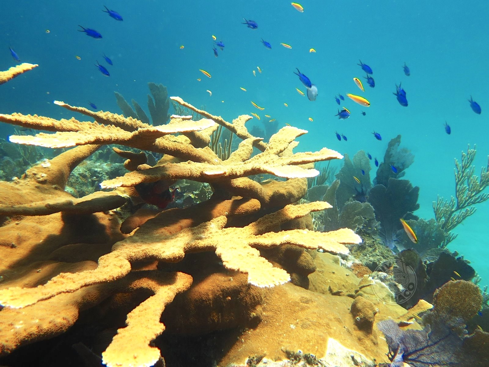
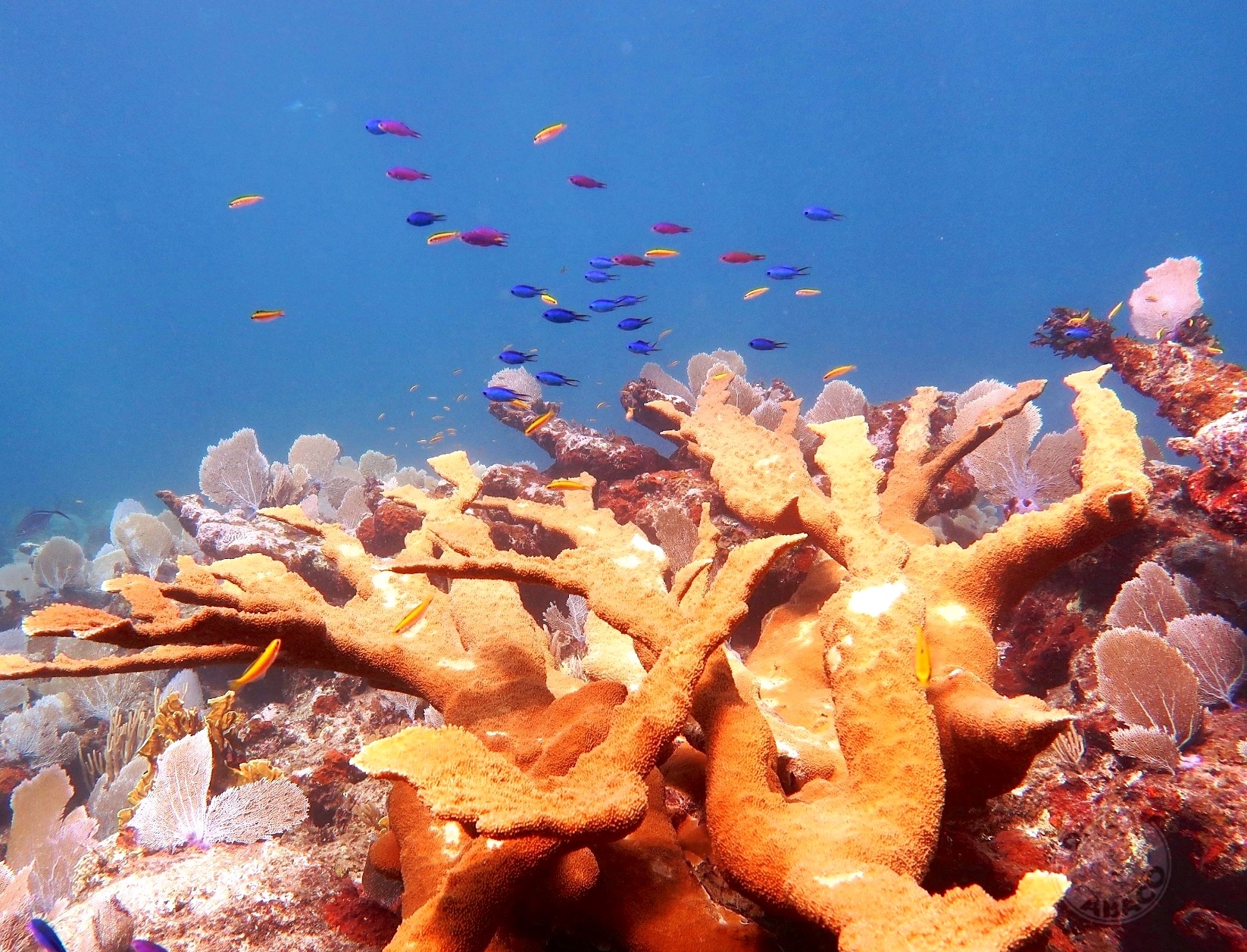
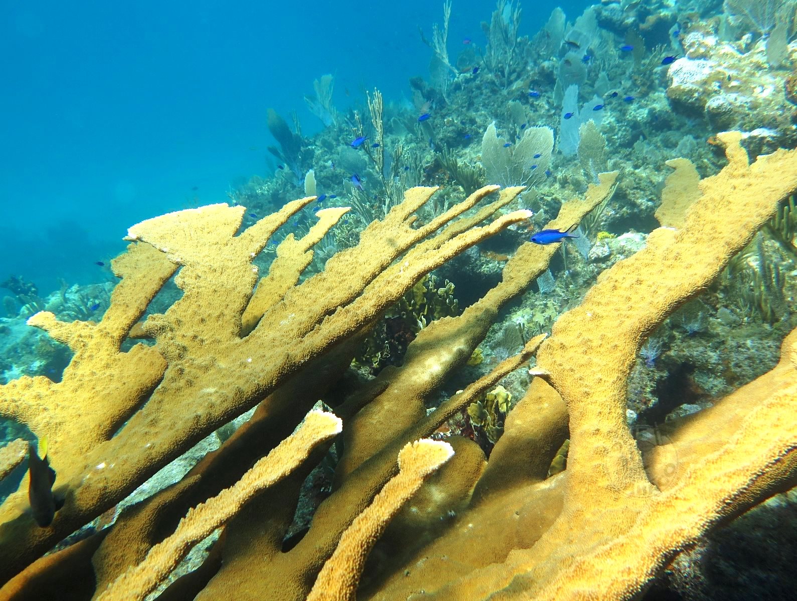
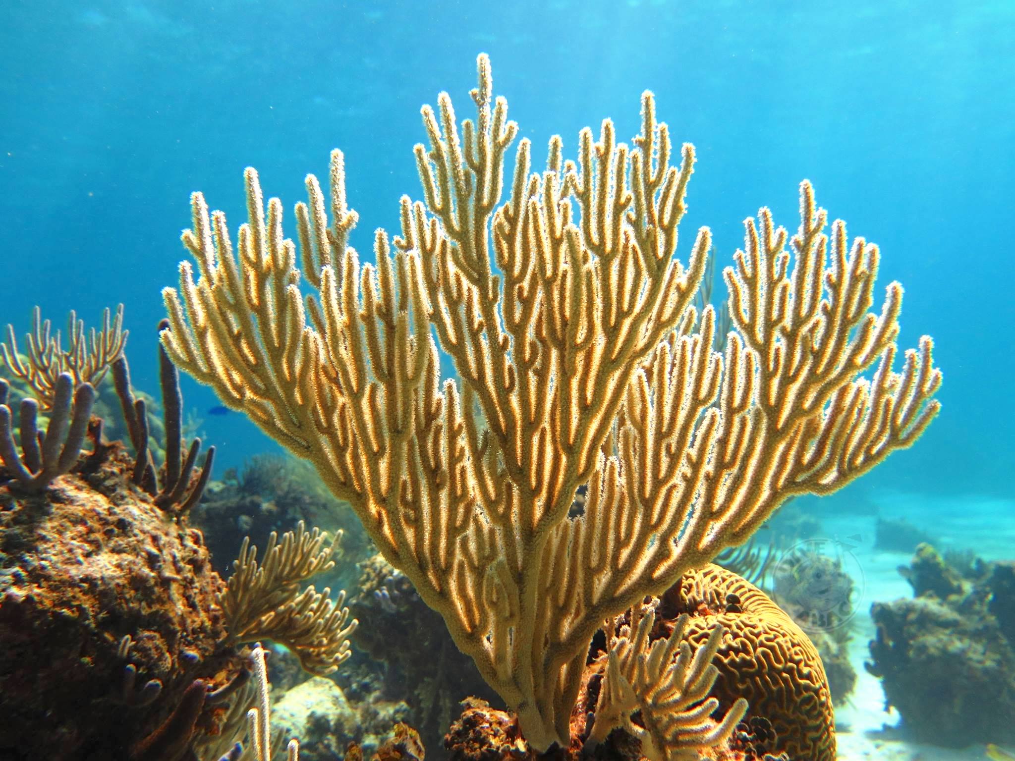
ELKHORN CORAL (Acropora palmata) is a widespread reef coral, an unmistakeable species with large branches that resemble elk antlers. The dense growths create an ideal shady habitat for many reef creatures. These include reef fishes of all shapes and sizes, lobsters, shrimps and many more besides. Elkhorn and similar larger corals are essential for the wellbeing both of the reef itself and also its denizens. These creatures in turn benefit the corals and help keep them in a healthy state.
Examples of fish species vital for healthy corals include several types of PARROTFISH, the colourful and voracious herbivores that spend much of their time eating algae off the coral reefs using their beak-like teeth. This algal diet is digested, and the remains excreted as sand. Tread with care on your favourite beach; in part at least, it will consist of parrotfish poop.
Other vital reef species living in the shelter of elkhorn and other corals are the CLEANERS, little fish and shrimps that cater for the wellbeing and grooming of large and even predatory fishes. Gobies, wrasse, Pedersen shrimps and many others pick dead skin and parasites from the ‘client’ fish including their gills, and even from between the teeth of predators. This service is an excellent example of MUTUALISM, a symbiotic relationship in which both parties benefit: close grooming in return for rich pickings of food.
VULNERABILITY TOCLIMATE CRISIS
Formally abundant, over the course of just a couple of decades elkhorn coral (along with all reef life) has been massively affected by climate change. We can all pinpoint the species responsible for much of the habitat decline and destruction, and the primary factors involved. In addition, global changes in weather patterns result in major storms that are rapidly increasing in both frequency and intensity worldwide.
Physical damage to corals may seriously impact on reproductive success: elkhorn coral is no exception. The effects of a reduction of reef fertility are compounded by the fact that natural recovery is in any case inevitably a slow process. The worse the problem gets, the harder it becomes even to survive, let alone recover, let alone increase.
HOW DOES ELKHORN CORAL REPRODUCE?
There are two types of reproduction, which one might call asexual and sexual:
Elkhorn coral reproduction occurs when a branch breaks off and attaches to the substrate, forming a the start of a new colony. This process is known as Fragmentation and accounts for roughly half of coral spread. Considerable success is being achieved now with many coral species by in effect farming fragments and cloning colonies (see Reef Rescue Network’s coral nurseries)
Sexual reproduction occurs once a year in August or September, when coral colonies release millions of gametes by Broadcast Spawning
All brilliant photos: Melinda Rogers, with thanks as ever for use permission
ELKHORN CORAL (Acropora palmata) is a widespread reef coral, an unmistakeable species with large branches that resemble elk antlers. The dense growths create an ideal shady habitat for many reef creatures. These include reef fishes of all shapes and sizes, lobsters, shrimps and many more besides. Elkhorn and similar larger corals are essential for the wellbeing both of the reef itself and also its denizens. These creatures in turn benefit the corals and help keep them in a healthy state.
Examples of fish species vital for healthy corals include several types of PARROTFISH, the colourful and voracious herbivores that spend much of their time eating algae off the coral reefs using their beak-like teeth. This algal diet is digested, and the remains excreted as sand. Tread with care on your favourite beach; in part at least, it will consist of parrotfish poop.
Other vital reef species living in the shelter of elkhorn and other corals are the CLEANERS, little fish and shrimps that cater for the wellbeing and grooming of large and even predatory fishes. Gobies, wrasse, Pedersen shrimps and many others pick dead skin and parasites from the ‘client’ fish including their gills, and even from between the teeth of predators. This service is an excellent example of MUTUALISM, a symbiotic relationship in which both parties benefit: close grooming in return for rich pickings of food.
VULNERABILITY TOCLIMATE CRISIS
Formally abundant, over the course of just a couple of decades elkhorn coral (along with all reef life) has been massively affected by climate change. We can all pinpoint the species responsible for much of the habitat decline and destruction, and the primary factors involved. In addition, global changes in weather patterns result in major storms that are rapidly increasing in both frequency and intensity worldwide.
Physical damage to corals may seriously impact on reproductive success: elkhorn coral is no exception. The effects of a reduction of reef fertility are compounded by the fact that natural recovery is in any case inevitably a slow process. The worse the problem gets, the harder it becomes even to survive, let alone recover, let alone increase.
HOW DOES ELKHORN CORAL REPRODUCE?
There are two types of reproduction, which one might call asexual and sexual:
Elkhorn coral reproduction occurs when a branch breaks off and attaches to the substrate, forming a the start of a new colony. This process is known as Fragmentation and accounts for roughly half of coral spread. Considerable success is being achieved now with many coral species by in effect farming fragments and cloning colonies (see Reef Rescue Network’s coral nurseries)
Sexual reproduction occurs once a year in August or September, when coral colonies release millions of gametes by Broadcast Spawning
All photos: Melinda Rogers, with thanks as ever for use permission
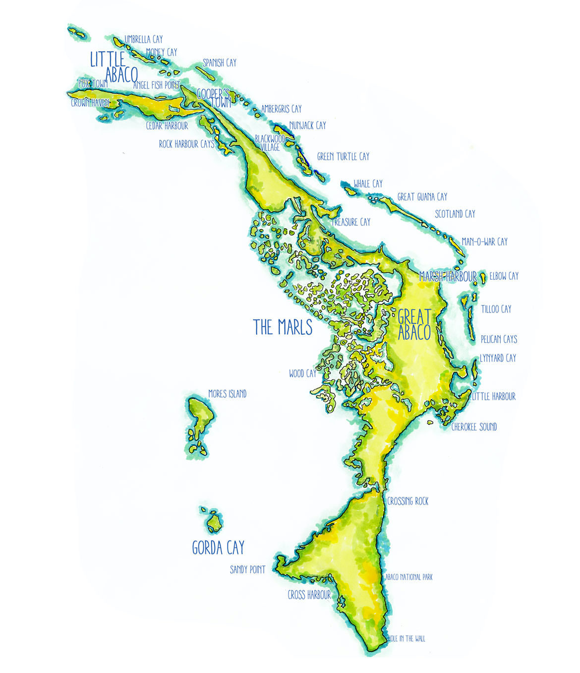
The spectacular coral reef chains of the Bahamas include the 3rd largest barrier reef in the world. Abaco’s reef system stretches from Little Harbour to beyond the northern end of the mainland, as Sandy Estabrook’s map shows. Inside the reef: the Sea of Abaco. Beyond the reef and the next landfall east: Western Sahara, south of the Canary Islands.
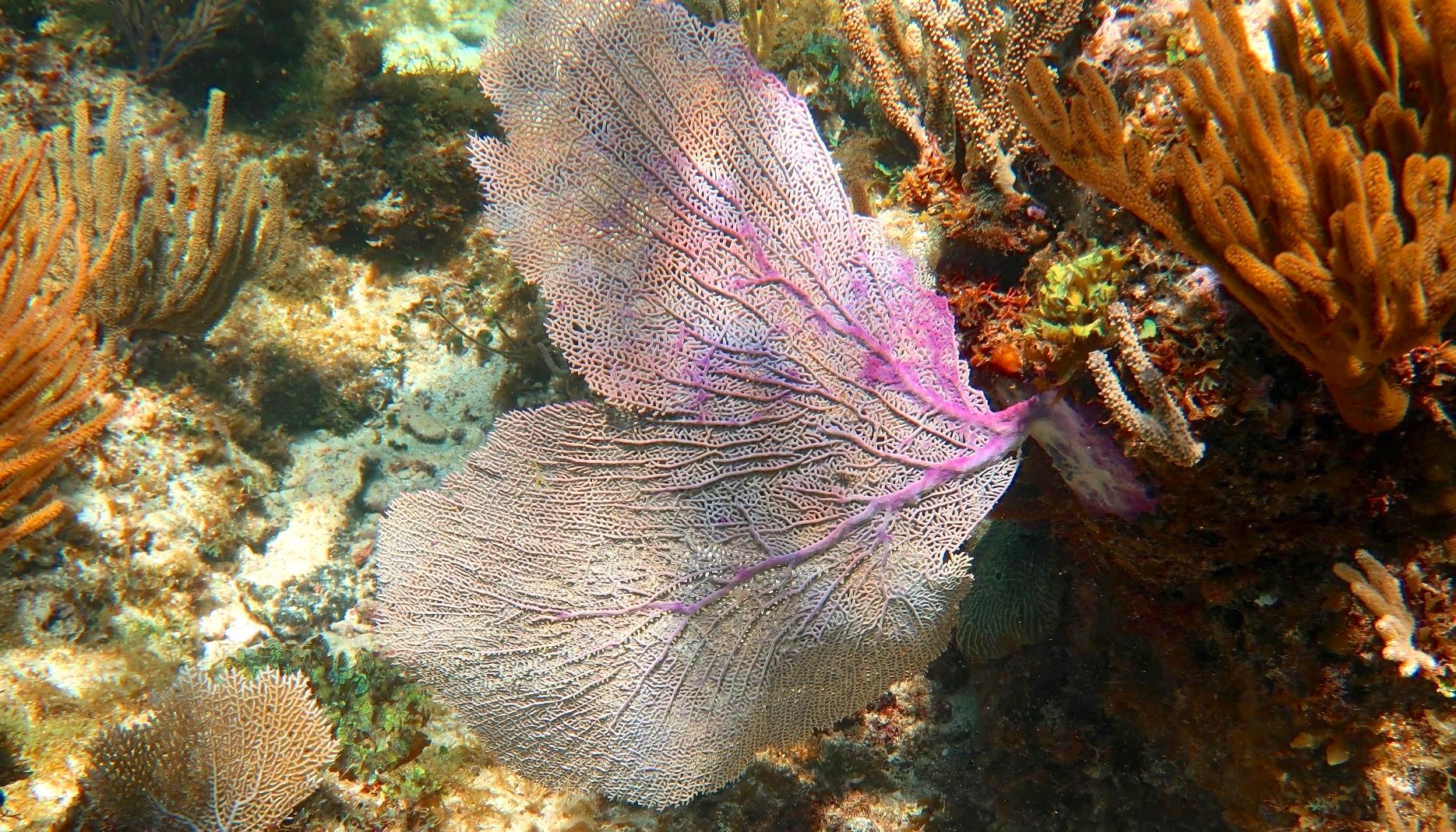
A rainbow effect of filtered sunlight on sea fans
Since the devastation of Abaco by Hurricane Dorian last September, a number of surveys have been carried out. Some of these relate to the impact of the storm on the natural world – the damaged forest and coppice, the bird-life including the Abaco specialities, and the marine life including marine mammals, fish, and reef structures and environments.
A recent assessment by the Perry Institute for Marine Sciences (PIMS) in Abaco and Grand Bahama waters has been carried out on the coral reefs to determine the extent to which the vulnerable structure, ecology and environment has been damaged. Some details have just been published in the Nassau Guardian in an article by Paige McCartney. The LINK is below.
DAMAGE FINDINGS IN BRIEF
25 – 30% of the 29 reef sites surveyed are devastated
factors include damage from debris, silt burial, and bleaching
uprooted casuarina trees were caught in the storm surge, causing damage
in particular, corals have been smashed and reef structure destroyed
there is biomass loss – basically reduced populations of fish & other organisms
RAYS OF LIGHT
Although the reef systems of both islands have been significantly damaged, in other areas little damage was found. Moreover, in some areas the storm had washed away some types of seaweed that are harmful to the reefs. The hope is that restoration of the damaged areas can be achieved with careful management.
WHAT CAN BE DONE NOW?
Action towards restoration and future protection includes:
removal of debris and other deleterious matter (eg silt)
cutting back the non-native, invasive casuarinas from the shoreline
restoration programs (recent successes with ‘coral farming’ could be vital)
extending marine protected areas
developing a rapid response protocol to meet extreme situations
The reports ends with some welcome news: Government departments have recently proposed putting $5 million towards a coral restoration project on Abaco, including the establishment of a and-based aquaculture facility to support coral growth in nurseries. Let’s hope that becomes a reality.
Spot the trumpetfish…
The publication of the PIMS report and its findings gives some hope of recovery for the fragile reef environment of the northern Bahamas. Other factors may reverse the optimism of course, not least the accelerating warming of the seas and the exponentially expanding pollution problem such as this, recently reported
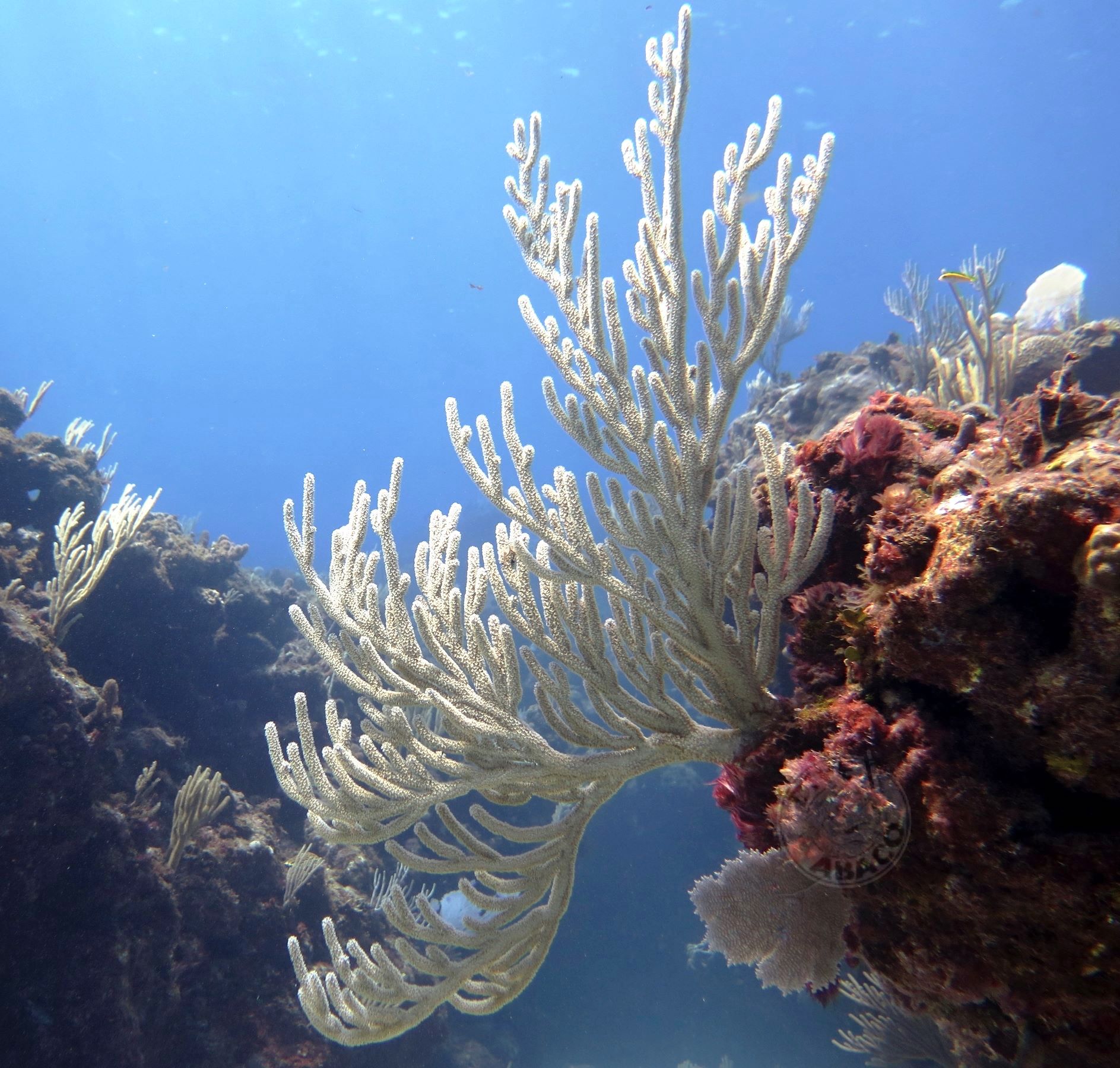
This has been an opportunity to revisit the clear waters around Abaco where Melinda Rogers of Dive Abaco took these astonishing photos of coral on the local reefs. If the coral is destroyed or dies, this is what our children and their children will be be missing.
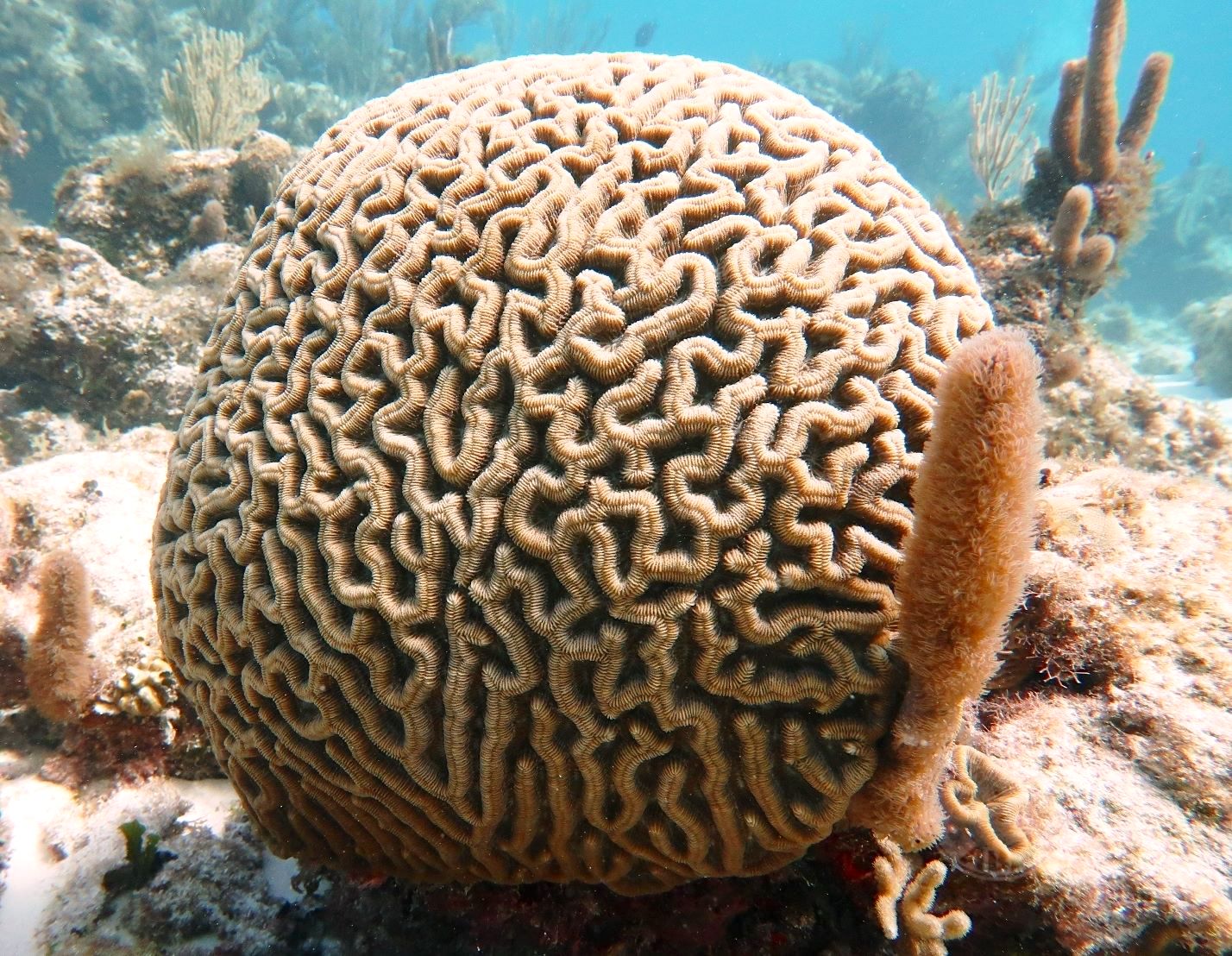
Click the brain coral to link to the Nassau Guardian Article
All photos, Melinda Rogers / Dive Abaco; Map, Sandy Estabrook; Nassau Guardian / Paige McCartney; Perry Institute for Marine Sciences (PIMS)
Elkhorn coral (Acropora palmata) is a widespread reef coral, an unmistakeable species with large branches that resemble elk antlers. The dense growths create an ideal shady habitat for many reef creatures. These include reef fishes of all shapes and sizes, lobsters, shrimps and many more besides. Some of these are essential for the wellbeing of the reef and also its denizens.
GOOD POST-DORIAN NEWS ABOUT ABACORAL
A recent report from FRIENDS OF THE ENVIRONMENT brings encouraging news about the reefs of Abaco post-hurricane, and an indication of the resilience of the coral to extreme conditions (with one exception for a reef too close to the shore to avoid damage from debris).
Shortly before Dorian hit, The Perry Institute for Marine Science and its partners surveyed reefs across Grand Bahama and Abaco to assess their health. Following Dorian, they were able to reassess these areas and the impact of the hurricane. Over the 370 miles that the surveys covered, minimal damage was found on the majority of reefs. Unfortunately Mermaid Reef, where FRIENDS does most of our educational field trips, sustained extensive damage due to debris from its close proximity to the shoreline. We are looking into how we can help with logistics to get the debris removed, and hopefully the recovery will begin soon.
The scientists were also able to visit four of the Reef Rescue Network’s coral nurseries and assess out-planted corals in national parks in both Grand Bahama and Abaco. The great news is that all of the corals on these nurseries survived the storm and will be used to support reef restoration. Also from the surveys, it appears that our offshore reefs around Abaco sustained minimal damage, including Sandy Cay Reef in Pelican Cays Land and Sea Park (pictured above). This gives us hope for the recovery of our oceans post-Dorian and proves how resilient these amazing ecosystems are.
Examples of species vital for healthy corals include several types of PARROTFISH, the colourful and voracious herbivores that spend most of their time eating algae off the coral reefs using their beak-like teeth. This algal diet is digested, and the remains excreted as sand. Tread with care on your favourite beach; in part at least, it will consist of parrotfish poop.
Other vital reef species living in the shelter of elkhorn and other corals are the CLEANERS, little fish and shrimps that cater for the wellbeing and grooming of large and even predatory fishes. Gobies, wrasse, Pedersen shrimps and many others pick dead skin and parasites from the ‘client’ fish including their gills, and even from between the teeth of predators. This service is an excellent example of MUTUALISM, a symbiotic relationship in which both parties benefit: close grooming in return for rich pickings of food.
Formally abundant, over just a couple of decades elkhorn coral has been massively affected by [climate change, human activity and habitat destruction] inexplicable natural attrition in many areas. One cause of decline that is incontrovertible is damage from storms, which are empirically increasing in both frequency and intensity, though apparently for no known reason.
Physical damage to corals may seriously impact on reproductive success; elkhorn coral is no exception. The effects of a reduction of reef fertility are compounded by the fact that natural recovery is in any case inevitably a slow process. The worse the problem gets, the harder it becomes even to survive let alone recover.
SO HOW DOES ELKHORN CORAL REPRODUCE?
There are two types of reproduction, which one might call asexual and sexual:
Elkhorn coral reproduction occurs when a branch breaks off and attaches to the substrate, forming a the start of a new colony. This process is known as fragmentation and accounts for roughly half of coral spread. Considerable success is being achieved now with many coral species by in effect farming fragments and cloning colonies (see above, Reef Rescue Network’s coral nurseries)
Sexual reproduction occurs once a year in August or September, when coral colonies release millions of gametes by broadcast spawning(there’s much more to be said on this interesting topic, and one day I will)
THE FEATURED PHOTOGRAPHS
You may have wondered in which healthily coral-infested waters these superb elkhorn coral photographs were taken. Did I perhaps source them from a National Geographic coral reef special edition? In fact, every image featured was obtained among the reefs of Abaco.
All except the recent Perry Institute / Friends of the Environment photo were taken by Melinda Rogers of Dive Abaco, Marsh Harbour. The long-established and highly regarded Dive Shop she and her husband Keith run was obliterated (see above) less than 3 months ago by Hurricane Dorian, along with most of the rest of the town. It’s a pleasure to be able to showcase these images taken in sunnier times.
ROCKET MAN: MORE MUSKY GIFTS TO ABACO’S PRISTINE BEACHES
THE STORY SO FAR
In early December a SpaceX (prop. E. Musk) Falcon 9 rocket was launched from Cape Canaveral. As it sped off purposefully into Space, the usual associated bits and pieces were jettisoned to fall with great precision into (a) open ocean and (b) a part where shipping was fortuitously absent. In due course (very quickly in fact), chunks of rocket debris turned up on the peaceful shores of Abaco. This is not unheard of: for example in 2012 we had a 12-foot fairing from the Curiosity Mars launch on the beach at Delphi (HERE); and in 2015 other space debris was found on Elbow Cay:
A CHUNK OF SPACE HISTORY, ELBOW CAY, ABACO, BAHAMAS (2015)
The latest space-debris festival on Abaco’s shorelines in December was first discovered at Bahama Palm Shores. ID was established from the partial red SpaceX / Musk logo visible in the below. The new arrival added to the ongoing excitement there of a huge 50′ and (sadly) dead sperm washing back onto the beach in a state of unattractive and ‘stay-upwind-at-all-costs’ decomposition…
Falcon 9 Rocket Fragment on the beach at Bahama Palm Shores, Abaco (2018)
This was quickly followed by a report from Tahiti Beach, Elbow Cay. You can read the details of these 2 events as follows: BPS HERE and Elbow Cay HERE.
Falcon 9 Rocket Fragment on Tahiti Beach, Elbow Cay Abaco Bahamas
As I mentioned in the Tahiti Beach post, a report from the west side of Abaco had just reached me from Charlotte Dunn, Director of the Bahamas Marine Mammal Research Organisation (BMMRO) at Sandy Point, Abaco. This was a surprising location because – with space-junk washing up on both sides of Abaco – an inference might be that the ‘drop’ area for nose-cones, fairings and the like might be somewhat wider than expected. Possibly wide enough to include a direct hit on land? Anyway, as promised, Charlotte has now had time to take some photos of Sandy Point’s involvement in the saga.
The top photo shows a long strip of space rocket, curving at one end. It’s obviously part of a larger part that was ejected after launch. In the Falcon 9 image below (note the logo matching the BPS part), the eye is drawn to the booster rocket fairings. Maybe it’s part of one of those. It’s not my area, so correction is invited, and probably welcomed if polite…
A SpaceX Falcon 9 rocket on the launch pad
WHERE ARE THE LOCATIONS IN RELATION TO EACH OTHER?
WILL THERE BE ANYMORE SPACE TREASURE WASHED UP ON ABACO?
With 3 sites now involved, and on both sides of the island, it seems very likely that more has washed up. However, there is so much unfrequented or inaccessible shoreline on Abaco that there may be no further reports from this launch. High tides will most likely take debris back out to sea and relocate it elsewhere.. We’ll have to see…
CAN I ‘BORROW’ A BIT OF ROCKET TO JOIN MY SEA GLASS COLLECTION?
That’s a very interesting question, thank you for raising it. We are in a grey area here, somewhere between things that (seem to) have been thrown away / discarded / abandoned by their owner (res nullius), which may be fair game; and items where it is safest to assume that – despite the careless and indeed haphazard nature of their ‘loss’ – they might still be of value, use or significance to the owner. Each case has to be looked at on its merits; overall, I suspect Mr Musk would like his parts back; alternatively that he may not want anyone else to take possession of them… He is litigious. Your call! In the UK people are bidden to take lost property to a Police Station. You could try that.
WHAT OTHER SPACE-X FLIGHTS OVER / NEAR ABACO ARE PLANNED?
Thanks to Jack Bowers who sent me the link to the SpaceX schedule. Here are some recent completed missions. Note the top one, a launch on 11th January. Now check your local beach…
DO YOU HAVE ONE OF YOUR MUSICAL DIGRESSIONS?
CREDITS: Jack Bowers & others at BPS; Mary McHenry (Elbow Cay); Sandy Walker (Delphi); SpaceX / Space News + Spaceflight Now (unclassified) online material; random debris from OS material
Mars Curiosity Launch: fairing on Delphi beach, Abaco 2012 (Sandy Walker)
Pliny the Elder (CE 23–79) was one of the earliest naturalists, besides being a philosopher, author and military commander. He wroteNaturalis Historia(Natural History), a wide-ranging work that became a model for later scholarly works, including forms of Encyclopedia. And, as he so nearly wrote, ‘si non amas testudines, vacua anima tua est’ (he that loves not sea turtles, has an empty mind)*.
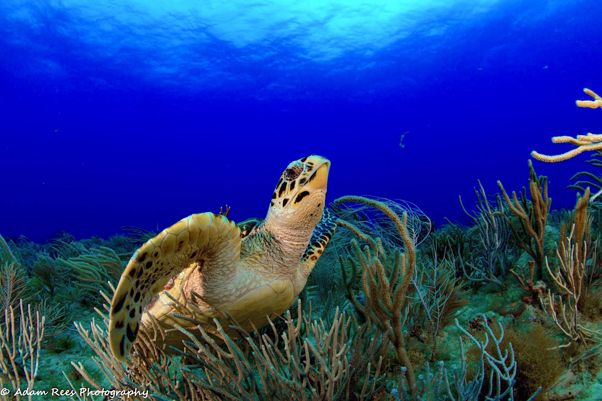
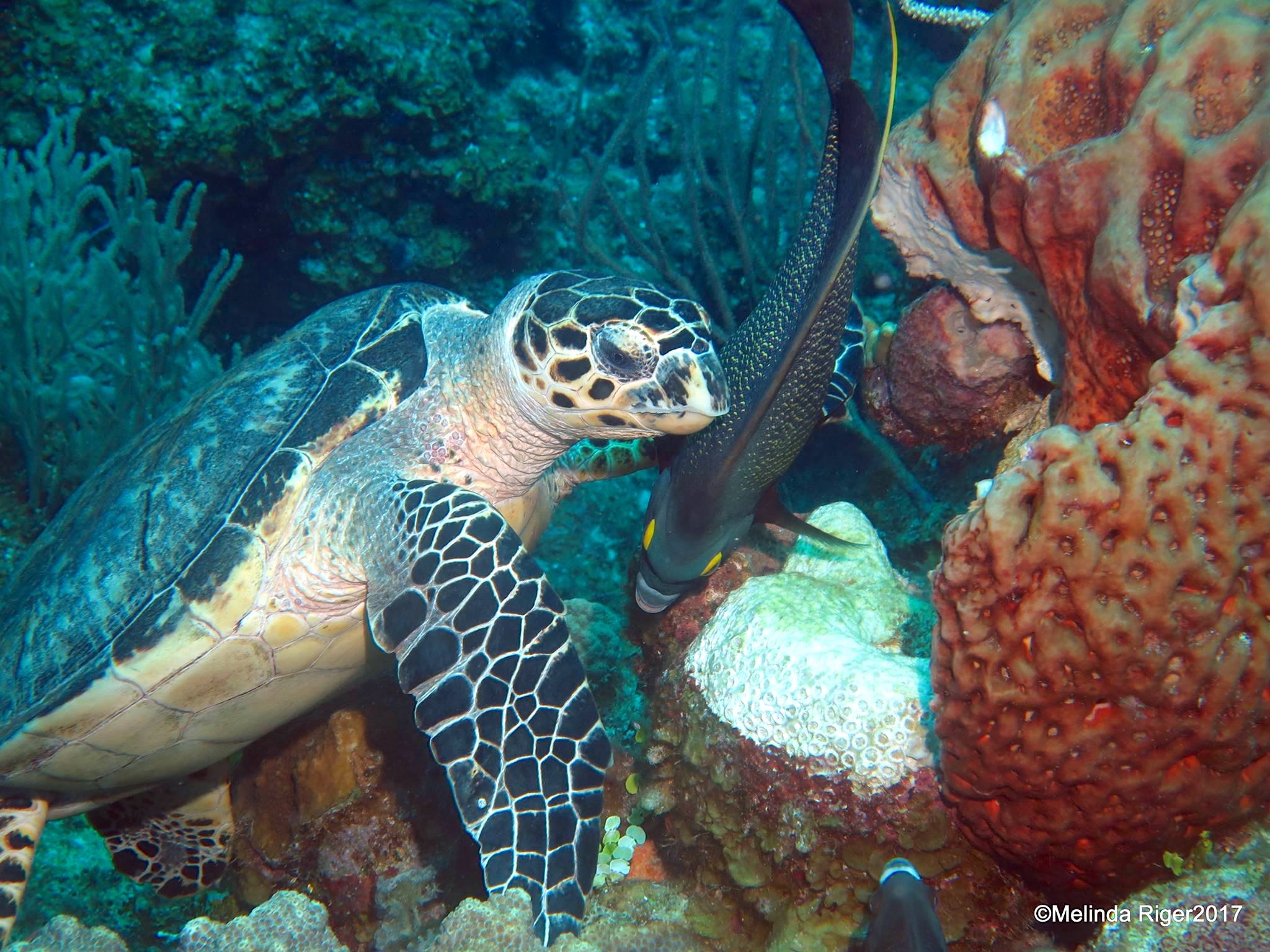
Hawksbill turtle grazing while a French angelfish looks on
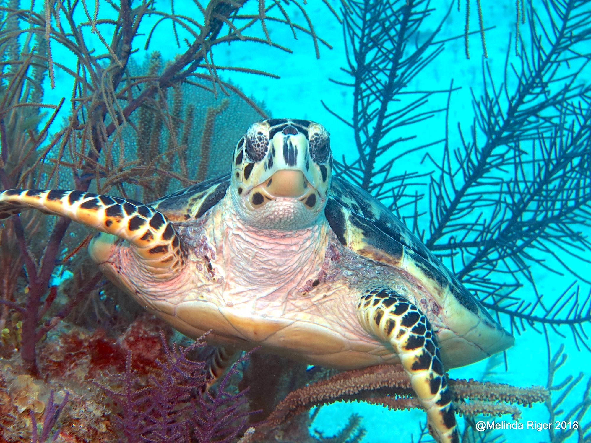
There can be few better ways to start the New Year than with some gorgeous Hawksbill Turtles Eretmochelys imbricata, plus a sprinkling of turtle facts to give 2019 a good push into orbit. Fortunately still available in Bahamas waters, the continued existence of Hawksbills is under serious threat. Make the most of your opportunities.
Guesstimates of the world Hawksbill Turtle population suggest that there are 5 main groups in the oceans, with few enough individuals – especially breeding females – to warrant an IUCN listing of the species as critically endangered
I doubt that many will forget that the next IUCN category is… extinct (≠ ‘fun fact’)
The largest Hawksbill colony in the world nests on an island in Queensland Australia
Turtles leave the sea to lay eggs in a hole dug on the beach, before returning to the sea.
The eggs hatch after c60 days… the turtlings emerge and are then on their own
Hawksbills are omnivorous, mainly eating sponges (& immune from sponge toxins)
They also eat sea anemones, mollusks, and jellyfish
Their grazing lifestyle is an important component of a healthy coral reef ecosystem
Though their shells are hard, Hawksbills are prey for sharks, crocodiles, octopuses and “the biggest predator of all, humans“.
Despite international Hawkbill protection and conservation measures, they continue to be illegally hunted – including, in some places, for food.
Their lovely shells – tortoiseshell – are illegally traded for use for ornaments and jewellery
Japan makes its own rules (as with whales) for traditional & no doubt research purposes
‘Tortoiseshell’ is the illegal item most frequently confiscated by custom officials
Reef and beach degradation, development, light pollution (confuses the baby turtles trying to paddle to the sea), ocean pollution / marine debris, and illegal practices are among the greatest dangers to the survival of the species. All are caused, directly or indirectly, by you and indeed me
Credits: wonderful photos by Melinda Riger / Grand Bahama Scuba (1, 2, 5) & Adam Rees / Scuba Works (3, 4, 6); Widecast; Nature Conservancy; OneKind Planet
*Do not believe this – I invented it. The pretentious quote that props up the other stuff, that is – all the rest is true…
ROCKET SCIENCE ON ABACO (2) / ELON-GATE: MORE SPACE DEBRIS
Having seasonally gifted Bahamas Palm Shores the benefit of the debris from his recent Falcon 9 rocket launch (see last post from BPS HERE) it turns out that Mr EM has spread his munificence rather wider on Abaco. And there may be still more to come.
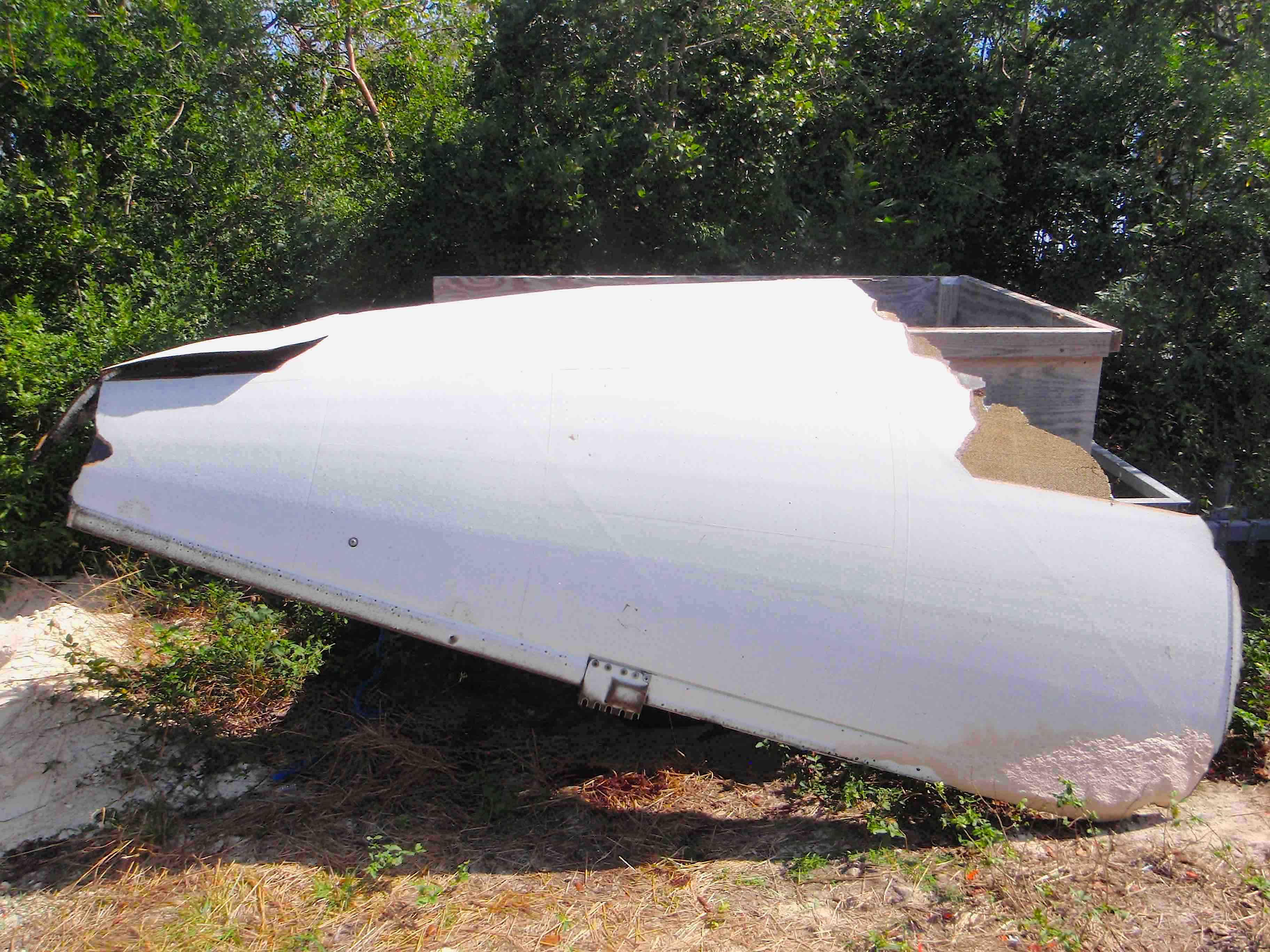
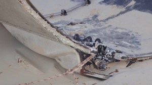
I pressed the ‘publish’ button re BPS a couple of days ago. Within hours, a further report was posted on the resulting FB thread. From Elbow Cay came the news that more space-related debris had washed up on beautiful Tahiti Beach. Mary McHenry posted 2 photos of a strange chunk of junk. I think we can reasonably assume that is from a rocket; and the timing is consistent with it being related to EM and his recent SpaceX program activities.
Mary’s photos show both sides of the gently curved item. I’ve no idea what part this is or what it does, but I hope that we can find out. It looks like a bit of fuselage, and presumably it is one of the parts that detach in the aftermath of a launch and falls back to earth to make an attractive and thought-provoking addition to the ocean and to whichever beach it turns up on.
In this case, it was Tahiti Beach (above), one of the most beautiful locations on Abaco. It is a beach in which I have a particular interest, because each year rare piping plovers hang out there in singles and pairs. It doesn’t seem to be their home, more like a little short-break destination for some quality foraging away from their usual stamping grounds. And to check out any space-based embellishments, of course.
A SpaceX Falcon 9 rocket on the launch pad
ANY MORE ASTONISHING ABACO SPACE HQ REVELATIONS IN THE PIPELINE?
Yes indeed. Within a few more hours I was contacted by Charlotte Dunn, Director of the Bahamas Marine Mammal Research Organisation (BMMRO) at Sandy Point, Abaco. They too had found some space stuff on their beach. This is interesting because, whereas Bahama Palm Shores and Tahiti Beach are on the east side of mainland Abaco, Sandy Point is on the west side. Somehow the debris seems to have spread surprisingly far and wide to both sides of Abaco
I’m waiting for some photos from Charlotte, then I’ll post Part 3 of what may be quite a long sequence. I say that in particular, because yesterday day there was news that another SpaceX Falcon 9 had been launched from Cape Canaveral carrying military hardware into space. I think we can guess where some of the components of this enterprise may wash up – those large pieces that detach over the ocean as the rocket ascends through the earth’s atmosphere into space. Keep your beach-combing shoes** handy… and a camera, maybe.
Tahiti Beach (drone’s-eye view)
CREDITS: Mary McHenry (1, 2); Samantha Regan; Bruce Hallett (bird); SpaceX + Spaceflight Now (unclassified) online material; David Rees (drone view); cartoon, OS; festive Christmas Tree Worms, the wonderful Melinda Riger (without whom… etc etc)
** Mmm. I don’t think these are a ‘thing’ at all; in this context I probably just mean ‘feet’
FINALLY, A VERYHAPPYXMASTO ALLTHOSETHATTOLERATETHISBLOGANDKINDLYCOMEBACK FORMORE
December has seen two remarkable events on Abaco. First, a huge dead sperm whale (estimated 50′ long) washed up at Bahama Palm Shores. Sharks had already had a go at it, and it was beginning to putrefy. An autopsy was unable to determine the cause of death (ship-strike is presumably a contender). It continued to decompose on the shoreline, becoming extremely… well, best kept at a distance. And upwind of it. I’ll post about the sad end of this magnificent creature – the largest marine mammal in the Bahamas – in a couple of weeks, after the festivities at Rolling Harbour Towers have calmed down.
———————————
STOP PRESS 🚀 you haven’t even reached the rocket part of this yet, but just to say that a few hours after posting this article, other reports of bits of Mr Musk’s rocket debris washed up on beaches are coming in – Tahiti Beach EC, and just now from BMMRO at Sandy Point. I’ll update tomorrow. 🚀
————————————
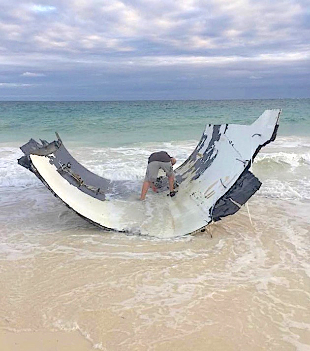
The second big news event for South Abaco was the discovery of a massive piece of (formerly) airborne debris drifting onto the BPS beach. Everyone was hoping the item wasn’t part of a plane fuselage, as it initially appeared to be. From the initial photos it looked to me like something from a rocket launch, maybe part of a booster rocket. It reminded me of the 12 foot part of a booster rocket fairing from the Atlas 5 rocket which launched Curiosity on its Mars mission, that washed up on the Delphi beach in early 2012. The men in black eventually came to reclaim it… More on that HERE
THIS REALLY IS ROCKET SCIENCE THEN?
Quite soon the mystery of the object’s purpose and origin began to get clearer. Luc Lavallee was quick to recognise the red external markings as matching Elon Musk’s logo, as used by his SpaceX venture. Events moved quickly. Contact with Musk’s operation confirmed that this was indeed “one of theirs”, a part from the latest launch a few days before.
AFTER a large chunk of strange space debris of (initially) unknown origin
BEFORE Elon Musk’s complete Falcon 9 Rocket – note the red ident
SO WHAT ON EARTH* WAS THIS CHUNK OF SPACE DEBRIS?
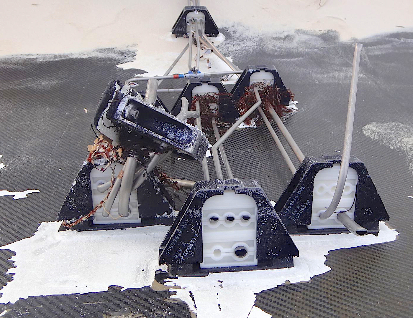
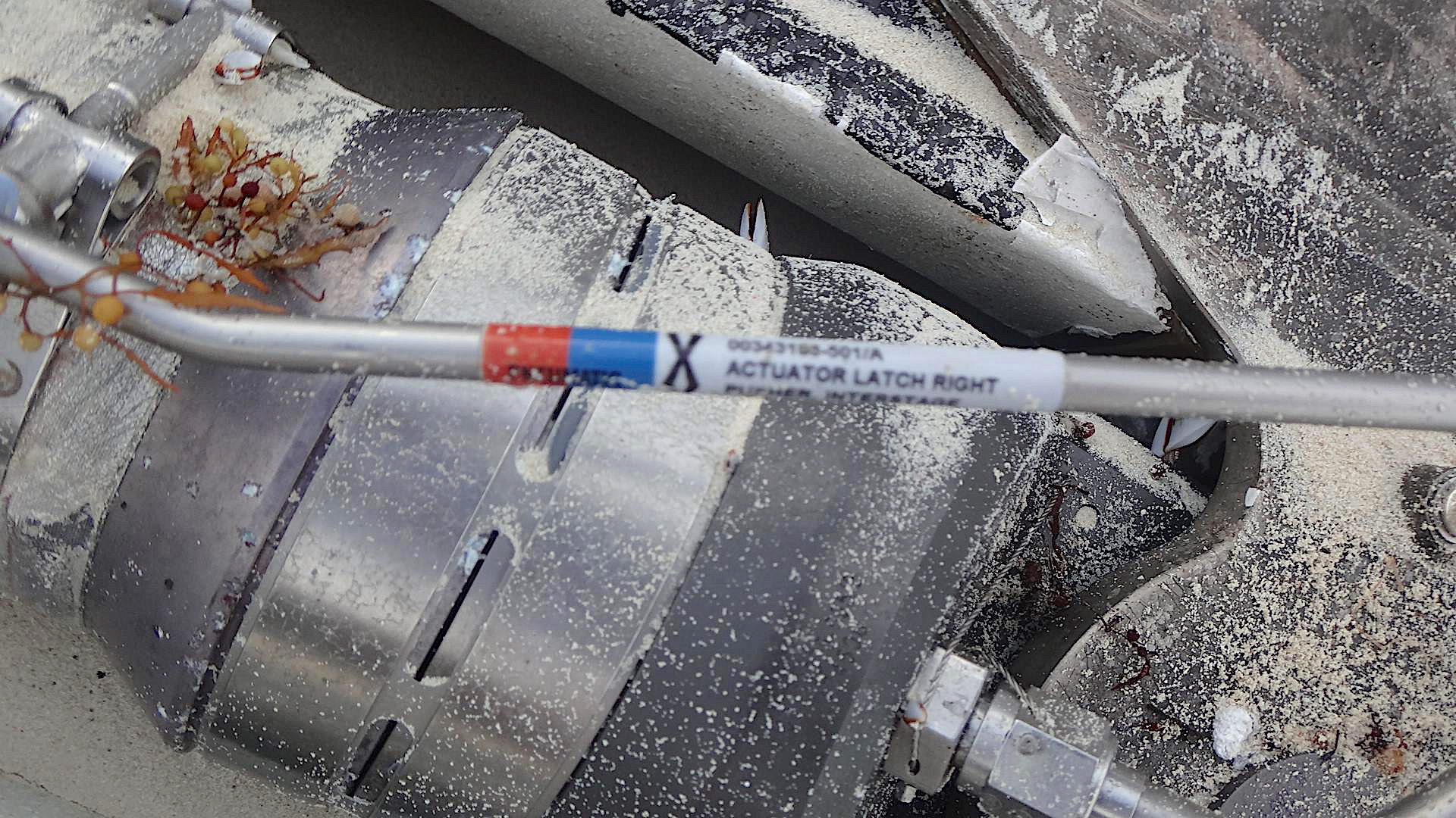
In the end the item was identified as part of the shroud from a Falcon 9 rocket. There was plenty of opportunity to take a good look at some of the workings. There’s potential here for some quality beach-combing (who would not want an ‘Actuator Latch Right’ rod in their living room?). There are interesting legal considerations in this type of situation… [Worried reader: please, no, I beg you]. Moving on, here’s a selection of rocket bits for contemplation.
More info was gathered, including the discovery of an astounding video from a camera fastened to a Falcon 9 rocket’s payload fairing, showing the nose cone spinning through space after its separation on a satellite launch earlier this year.
WHAT DOES A ROCKET SHROUD DO?
The nose shroud shields satellites during final preflight preparations and the early stages of launch. Once the rocket reaches space — an altitude above 100 kms / 62 miles — it jettisons the payload fairing to fall back into the ocean. The Falcon 9’s fairing is released in two halves, like a clamshell.
*This is the sort of occasion when people write ‘no pun intended’, though in fact they generally intend one, just rather a feeble one. Like mine, in fact.
CREDITS: Jack Bowers and others from the BPS community for photos, info and investigative acumen; SpaceX + Spaceflight Now (unclassified) online material + videos generously posted on YT; USA Today
Of all the sea creatures in the limpid waters of the Bahamas, turtles are rightly among the most loved. These days, what with habitat degradation below the waves and the destruction of nesting sites on land, turtles have a hard time simply fighting for survival. And that’s before they have ingested the plastic garbage that mankind pours into their living quarters, by now probably beyond effective remedial action forever. So here are some gorgeous turtles to admire, while stocks last…
Hawksbill Turtles enjoying life around a still-healthy reef
A hawksbill snacking on a sponge
Interaction with other underwater species: gray angelfish and a rock beauty
If you are concerned about the plight of turtles and indeed other denizens of the thickening plastic soup we still call ‘ocean’, you could investigate the work some of the organisations that tackle the problem in the Bahamas and beyond. To name but a few, our own FRIENDS OF THE ENVIRONMENT; the BAHAMAS NATIONAL TRUST; the Bahamas Reef Environmental, Educational Foundation BREEF; the CAPE ELEUTHERA FOUNDATION; and the SEA TURTLE CONSERVANCY.
Photo credits: all great photos by Melinda Riger / Grand Bahama Scuba
THE THREATS ARE REAL AND THESE PHOTOS SHOULD ALARM YOU!
I rarely – in fact almost never – lift an entire article from elsewhere and plant it wholesale here. I make an exception today. Ben’s article is so relevant, so well put together, so compelling and so scary in its implications that it can’t be ignored. No individual is to blame. We all are. Mankind generally – and pretty much all of it in my lifetime. Walk any beach in Abaco, however secluded. There it all is, under your feet. Find a dead seabird? Chances are it will have significant amounts of plastic inside it. Seen those wretched images of turtles with plastic bags hanging out of their mouths? It’s going to get worse…
Now see how things are with our bird partners in New Jersey and their beautiful ospreys.
DOCUMENTING THE PRESENCE OF PLASTICS IN OSPREY NESTS
U.S. Coast Guard assists NJ Fish & Wildlife with recovering an entangled osprey on a channel marker in Cape May Harbor, Summer 2018. photo by Kathy Clark/ENSP
The alarming trend is also becoming more deadly for ospreys, and other marine life who ingest it. While it might not seem like a lot, this year a total of four young ospreys were found dead from being entangled in plastic. In my books, one dead osprey is too many! This is not a natural cause of death! Luckily, there were several other entanglements that were prevented, but this trend is likely to get worse. We hope that these photos will help you to do all that you can to help prevent it from becoming a growing threat to ospreys and other marine wildlife, who might ingest plastics.
Ospreys are an indicator species. We can’t stress that enough. The health of their population can be directly linked to their surrounding environment. When we poisoned the land with persistent pesticides, the ospreys told us. When we overfished menhaden, the primary prey item of ospreys during the nestling period, the ospreys told us. When we use and discard plastics with no care, the ospreys will tell us…
From the land, where they collect nesting material, to the water, where they forage for prey. The growing presence of plastics on land and in water, highlights need to restrict single use plastics, balloon releases, and for any single use plastic fee to directly fund cleanups of plastic waste. It’s no surprise that ospreys use plastic items in their nests. It’s now become a common resource for them which looks similar to natural nesting material and collects in the same areas where they gather nest material. The more plastics in the world means more plastics in osprey nests!
Sadly, this is only the beginning. Plastics don’t biodegrade and this is becoming a chronic issue. Almost all osprey nests in New Jersey contain some type of plastic (next year we are planning to add data fields to our nest survey datasheets to keep better track of how many nests contain plastic). It’s still too early to see the effects of plastics as as they bioaccumulate in the food chain of predatory animals, like the osprey, but we hope that we can prevent this. We can all help by reducing our use of single use plastics. Here are some simple ways that you can help:
Never release balloons! Talk to your friends/family about where balloons actually wind up.
Reduce your dependence/consumption of single use plastics: bring your own reusable bag, water bottle, and coffee cups. Buy beverages in glass or aluminum containers. When eating out or getting take out, ask for no single use plastic items and/or bring your own container for leftovers. Support a Surfrider Foundation Ocean Friendly Restaurant!
CREDIT: Ben Wurst and his team at http://www.conservewildlifenj.org for the article. Photos as credited in the text. We are Bahamas partners of this organisation in Piping Plover research on the shores of Abaco and our annual Abaco Piping Watch
‘WELL SPOTTED’ (2): ATLANTIC SPOTTED DOLPHINS IN ABACO
No sooner have I posted aboutPANTROPICAL SPOTTED DOLPHINS sighted during the current BMMRO whale research program, than the other Bahamas spotted dolphin species shows up as well. These are the more numerous Atlantic Spotteds Stenella frontalis, more confined in range (as the names suggest) than the Pantropicals.
The BMMRO caption reads “Atlantic spotted dolphins today! Small social group playing with sargassum – they swam past what looked like a plastic mattress cover – one dolphin whacked it with its tail as it swam by…”
Just because it can…
RUBBISHING RUBBISH: A RANT
Behold a large plastic bag, made by humans and dumped by humans into a place that is not theirs to use as a trash repository. It will take some 500 years to break down completely. But when people say that they don’t really mean it will have harmlessly disappeared over that period and become salt water. Far rom it. It will just break down into smaller and smaller pieces, to bite-sized bits for turtle, fish and seabirds who will idiotically mistake them for food (duh!), then to micro-plastic that will become part of the evolving plastic soup that will be ingested by tiny sea creatures and coat the reefs in polyethylene gunk. [End of rant. Ed.]
Behold an Atlantic Spotted Dolphin giving the bag a passing whack with its tail. It won’t do anything to help with marine pollution, but is shows a robust disdain for a piece of man-made rubbish that has made it into the creature’s home environment.
Below is a short GoPro shoot of a pair of ASDs, that I took from the BMMRO research boat last year. Marvel at the grace and elegance of these beautiful animals as they swim just below the surface (wonder, too, at the incompetence of the cameraperson who, to be fair, was leaning over the side of the RHIB with the camera on a stick…)
All photos BMMRO; video from the Rolling Harbour achives, intemperate rant all my own
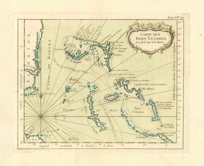
Jacques Nicolas Bellin (1703 – 1772) was a French naval hydrographer & geographer. He was a prolific mapmaker, especially of French territories, and was noted for his meticulous technique and attention to detail. He was elected to the Royal Society; and in due course was appointed Official Hydrographer of the French King.
In 1764, Bellin’s Petit Atlas Maritime was published. I am featuring one sheet from the atlas, the “Carte des Isles Lucayes”. The whole work came as a 5-volume set of map sheets, containing a total of 580 detailed charts. As you will see here, this copperplate engraving can be found in various forms: plain black & white; hand-washed or hand-coloured; or grandly multicoloured. These variations are the consequence of the distinction of Bellin’s work, which led to repeated re-publication in the c18 and beyond. Additionally, his work was admired and copied abroad.
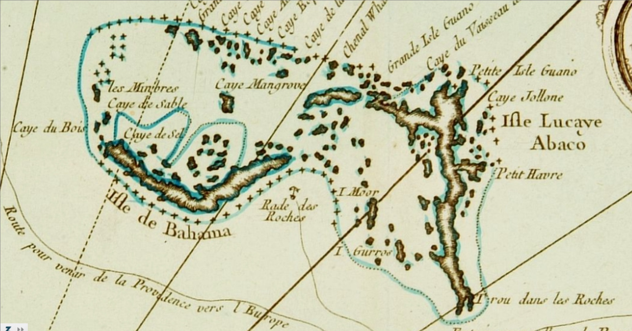
Bellin’s map contains plenty of information – including depth markings and advised shipping routes – though some of the topography might be considered debatable by modern standards. As you look more closely, some of the details are startling. For example, on New Providence (see above) the only place-name is simply designated ‘Ville’, as though the settlement there lacked the significance to merit a name. And look at it now… Andros is completely name-free, with not even a Ville marked – as is Grand Bahama for that matter, though a few Cays are named. Let’s turn to Abaco.
This section of the Bellin map also appears in my Abaco mapping article relating to HOLE-IN-THE-WALL. This geographical feature at the southern extremity of Abaco (now sadly blown apart by HURRICANE SANDY after millennia) was an important navigational landmark for shipping by c17. The name, in French here, underwent a number of changes of the centuries, as you can see using the HITW link above.
Also of note is that at least Abaco was credited with a single named location – Little Harbour, the first settlement to feature on early maps, and the only one for a surprisingly long time. I imagine the position of this inlet and the safe anchorage it could provide for relatively large vessels became well-known. Like Hole-in-the-Wall, it was of seafaring significance.
A c18 mariner, looking at Bellin’s map in contemplation of a trip to the Isles Lucayes, might conclude that the seas around Abaco and Grand Bahama might be treacherous. The profusion of rocky areas and the indication of depth changes around the islands and cays suggest caution would be needed for a voyage. And as we know, throughout history ships have been wrecked in these seas – a situation somewhat improved (but not entirely eliminated) when the threeABACO LIGHTHOUSES were built.
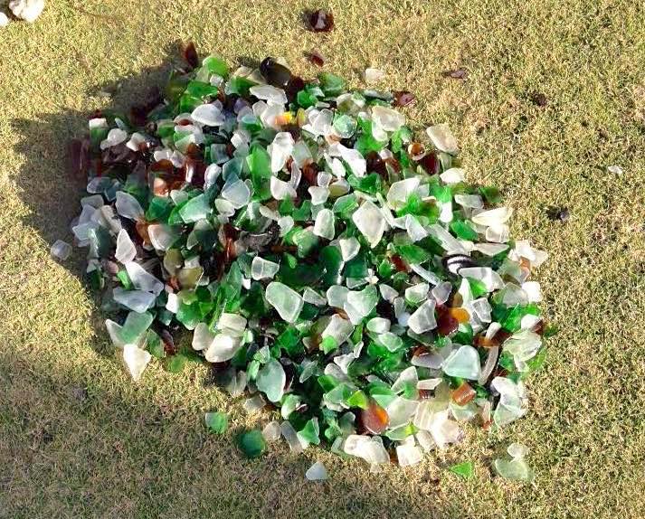
It’s time to shine the Rolling Harbour spotlight on sea glass, a neglected (by me) topic recently . Everyone loves it (don’t they?), and there’s always a bit of excitement in finding a pretty piece of cloudy glass gleaming in the sand on the beach. Just look at that colour. Might it be rare? How old could it be? Should I pick it up or leave it for someone else to enjoy?
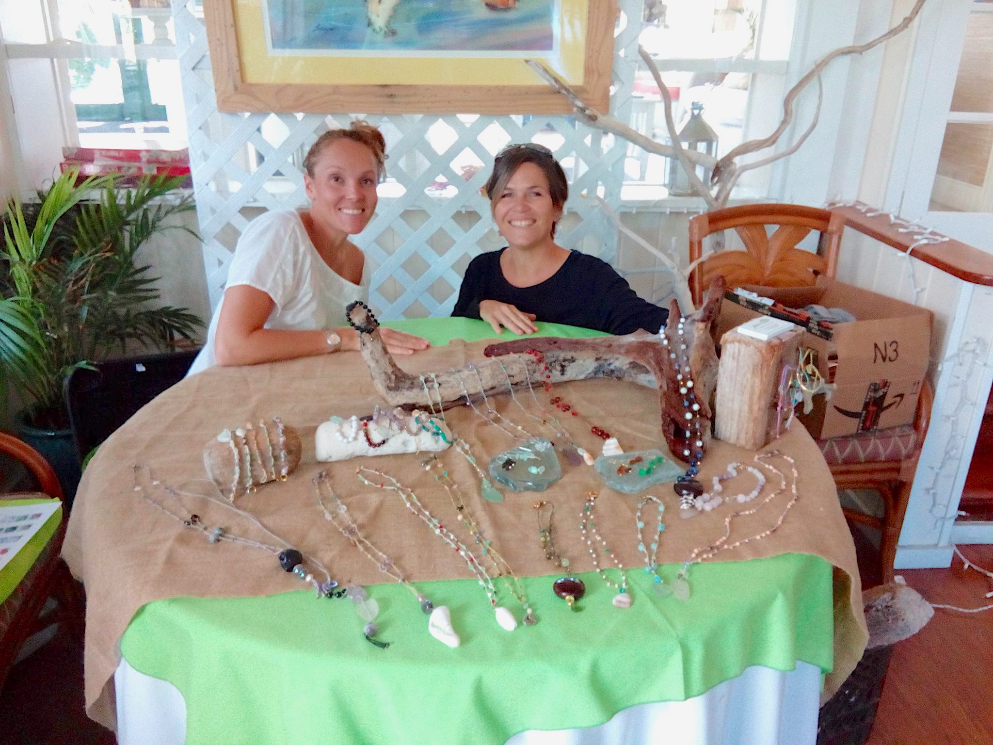
Collecting sea glass is one of the pleasures of a walk on the beach. Or maybe it’s the motivation for the walk. For some, it is an opportunity to turn what the sea throws onto the beach into something decorative. Abaco is home to some excellent jewellery** makers who specialise in using locally found materials to make beautiful things. These sometimes incorporate a mix of sea glass, pebbles, and small shells.
In Hopetown on Elbow Cay, Hilary Thompson and Erika Feszt Russell do just that. Trading under the name ‘Two Island Chicks’, they use sea glass in many of their creations, some examples of which are displayed here. As you’ll see, they also apply their creativity to showing their jewellery attractively.
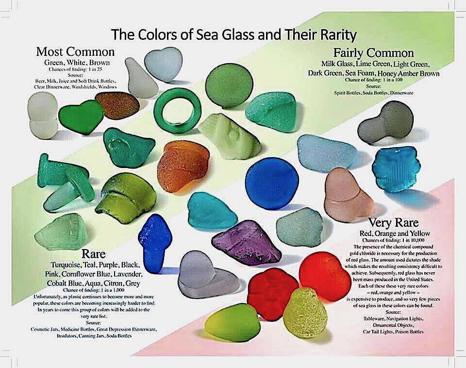
The collected glass has to be sorted into the various colours. Most are quite common (white, green, brown), some are uncommon (eg cobalt blue), and just a few that are very rare – and possibly valuable (red, orange) – see charts below.
The charts below give a general overview of the comparative rarity of various sea glass colours, their sources, and the chances of making a rare find. Of course, these are mainstream colours; there are many other in-between hues and shades.
Can you spot the most unusual piece of sea glass here?
** Yeah yeah, I hear you. Jewellery? How English is that? Please mentally substitute ‘jewelry’ throughout. Maybe the same for colour / color. This is a bi-lingual area.
THE TWO ISLAND CHICKS
Credits: Hilary and Erika for all the photos; as for the sea glass charts (1) West Coast Sea Glass 2006 (as found in a number of online sources); (2) Origin unknown (ditto re online sources)
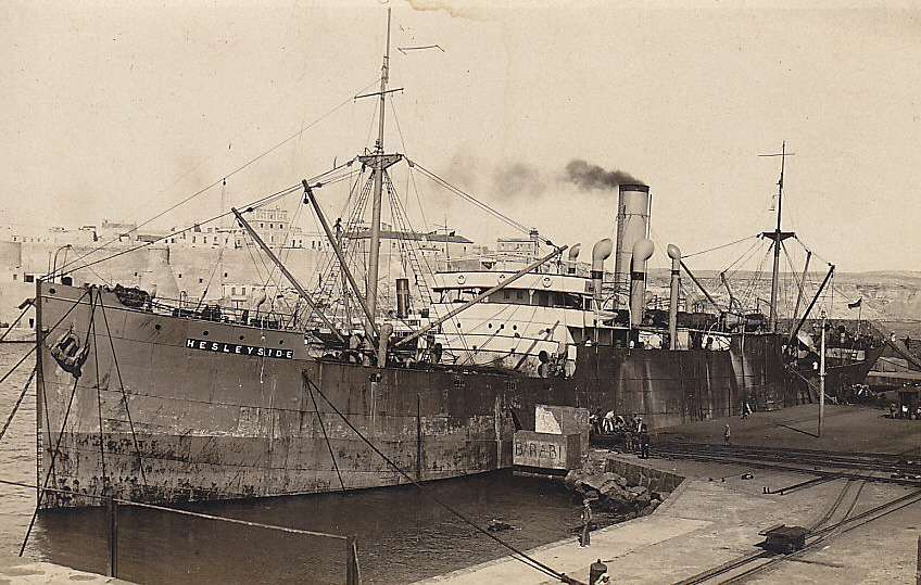
Abaco, like many of the islands of the Bahamas, has its fair share of wrecks around its shores – both ancient and modern. I reference some of these under my RANDOM menu, with some maps, links, and general information. One that I didn’t include is the SS Hesleyside, a wreck that lies broken and wave-tossed on the rocks at Schooner Bay. To reach it, you will have to arrange at the entrance for a golf-cart to take you down to the shore. The price for your transport may be an invitation to take a tour of the community there, an ambitious enterprise that was started about 10 years ago.
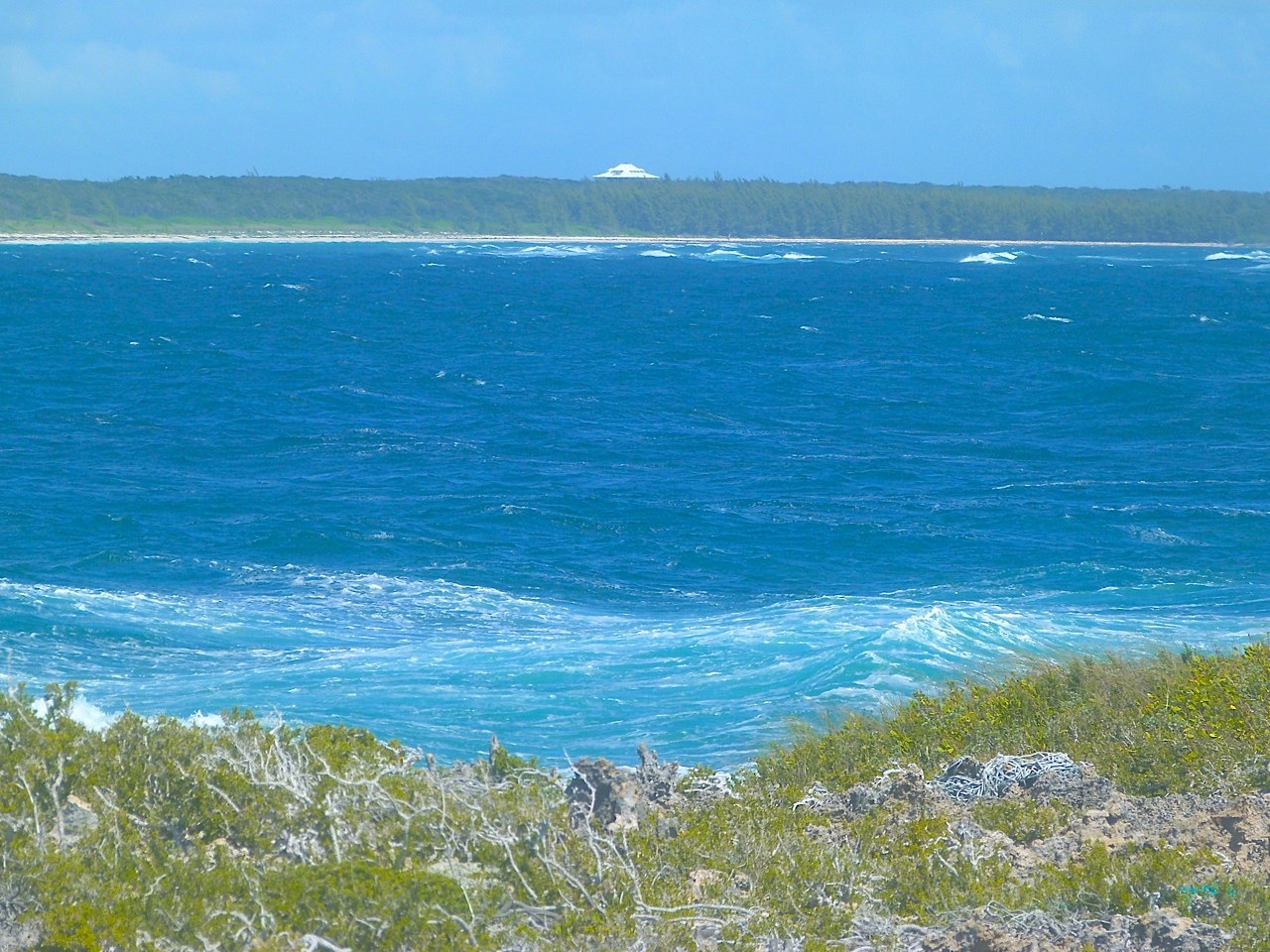
From where the Hesleyside lies, you get a long view across to Delphi, some 3 miles to the north.
For the energetic, you can walk the beach of Guinea Schooner Bay all the way to Delphi. However, the unpopulated strand is covered in seaweed (good for wildlife, though) and horrendous quantities of plastic, from micro off-cuts to macro bollards, oil containers and so forth. Frankly rather off-putting.
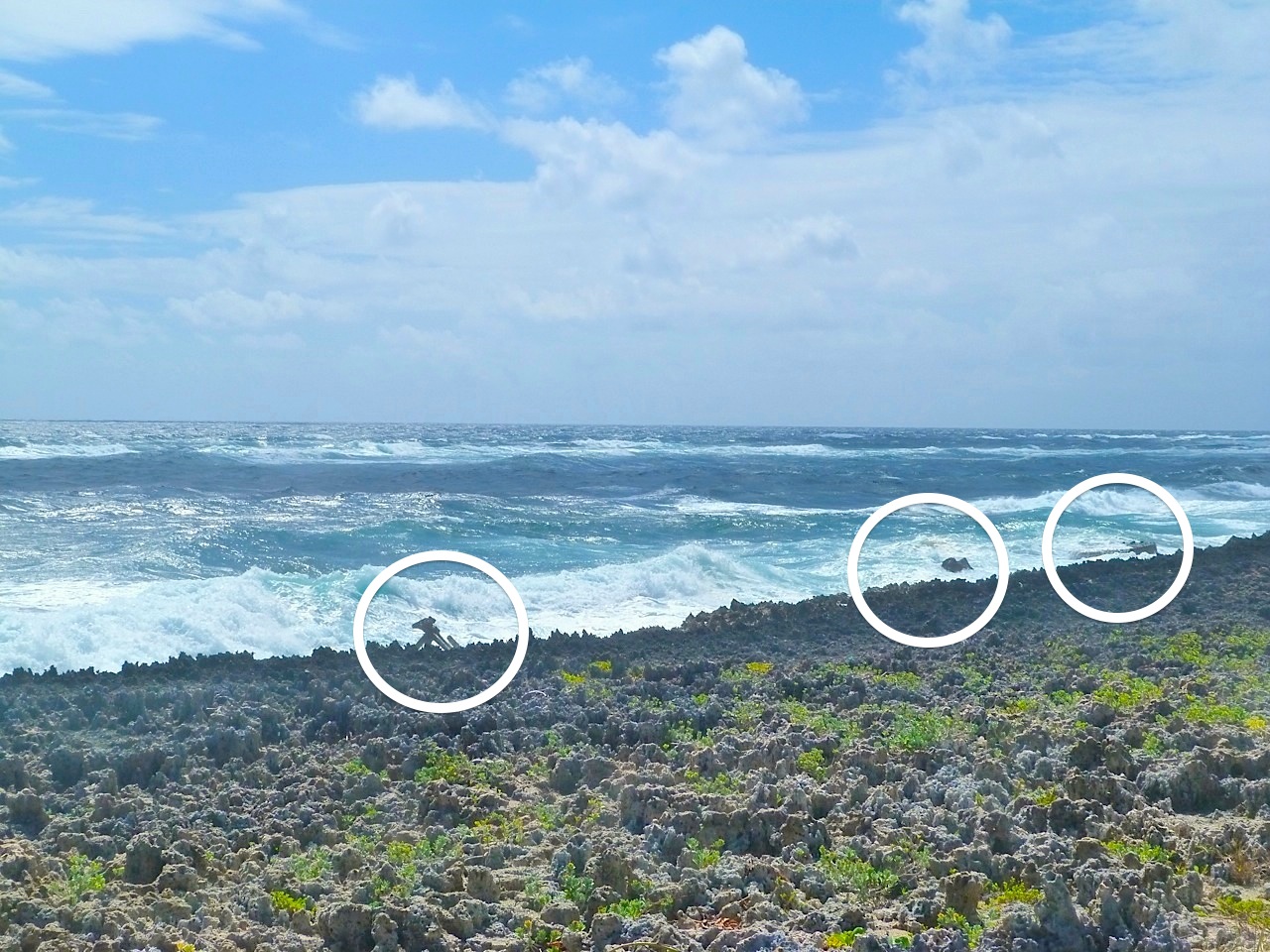
We visited Schooner Bay on a bright day with a strong wind that whipped up the waves all along the shoreline, with clouds of spray rather detracting from the photographic possibilities. The tide was high, and the remains of the wreck were at times barely visible.
The bow, part of the central section towards the stern, and some sort of boiler (?) at the stern
SS Hesleyside was a British cargo ship built in 1900 in Sunderland, England for the Charlton Steamship Co. (Charlton, McAllum). Steam-powered, the 2600 ton vessel was more than 300 foot long. In 1908 she was was sailing from the Azores to Key West when bad weather struck, and on 1st October high winds – described in contemporary reports as a hurricane – drove her aground where her remains now lie, a part of the coastline known as the ‘Iron Shore’. Fortunately the crew were able to escape, and there was no loss of life.
A dramatic account of the shipwreck was published in the New York Times. The hero of the crisis was fireman Jack Thompson, who with notable courage volunteered to swim ashore with a line, by which the rest of the crew were able to make their way to safety.
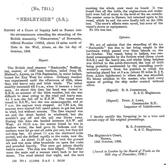
Report from the New York Times
In accordance with standard practice, a Court of Inquiry was held in Nassau two weeks after the event to investigate the circumstances. The Master was exonerated of blame, having “tried every means of getting the ship under control without effect”.
One interesting nautical and topographical note is that the site of the wreck is described as “about 18 miles north of Hole in the Wall”. The navigational importance of HITW as a landmark was known from as early as the c17, and it was the first location to be named in the earliest maps of Abaco. For a detailed history of HITW in maps, click HERE
Nautical Map, 1856, showing the seas around ‘Le Trou dans le Mur’, and the lighthouse SS Hesleyside details (wrecksite.eu / Tony Allen) [the date is wrong]
WHO, WHAT OR WHERE IS HESLEYSIDE?
It’s a place in Northumberland, UK – inland, but not very from where the ship was built. Many of the Charlton ships began with an H and ended in …side. It was – and is – a common practice to have a naming theme for vessels.
THE WRONG SORT OF HESLEYSIDE
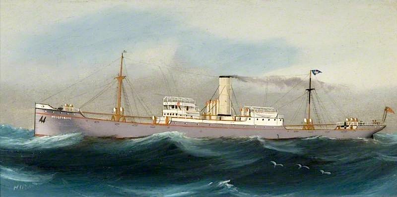
I got quite excited when I thought I had tracked down a painting in the Sunderland Museum of the SS Hesleyside. After all, there could hardly be two steam ships with the same name, could there? Wrong. There were in fact 3 ‘Charlton’ Hesleysides in all. There is some coincidence (but not necessarily ‘irony’, Alanis Morissette) that all 3 were wrecked.
Hesleyside (1)
86089
1882
688
Ex-Turgenief, 1882 purchased from Baxter & Co, Sunderland r/n Hesleyside, 24.7.1893 wrecked at Sosnowetz.
Hesleyside (2)
110353
1900
2631
4.10.1908 wrecked at Abaco, Bahamas.
Hesleyside (3)
133508
1912
3994
1933 sold to P. Hadoulis, Andros, 1935 sold to M. Sitinas, Andros, 24.5.1940 torpedoed and sunk in 48.30N 09.30W by U.37
The rather glamourised painting shown above shows Hesleyside Mark 3 her glory days. She was built in 1912 but was sold in 1933 to a Greek company and renamed SS Kymas. Under that name she was torpedoed by a U-boat in May 1940, and 7 of her crew of 30 were killed. The photo below (which took me a long time to decide was the same Helseyside) shows a much more steamery, freightery looking vessel…
Today the NOAA and other worldwide ocean guardian organisations are celebrating World Oceans Day. Looking at the websites and FB pages, one message is clear: People Are Rubbish. To put it another way, the global pollution of the oceans is caused solely by humans. The pristine seas and beaches of the world were unsullied until, say, the last 200 years. In 4 or 5 generations, all that has changed irreversibly.
My rather (= very) negative intro is counterbalanced by some more positive news: there are plenty of good guys out there working hard to make a difference to the rising tide of filth polluting the oceans. Clearing seas and beaches of plastic and other debris. Collecting tons and tons of abandoned fishing gear. Rescuing creatures trapped, entangled, injured and engulfed by marine debris and pollutants. Educating adults and – far more importantly – children and young people by actively involving them in their campaigns. Conducting research programmes. Lobbying and protesting. And a lot more besides.
A marine garbage patch: the sea creatures’ view (NOAA)
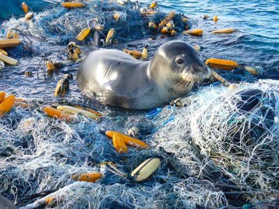
Abandoned fishing gear: a monk seal that was lucky; and a turtle that wasn’t (NOAA)
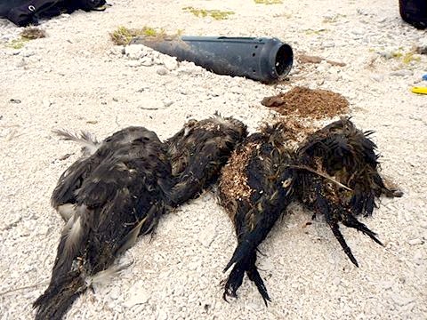
Four shearwaters killed by a cone trap. A fifth was rescued (NOAA)
The NOAA and sister organisations carry out massive programmes of clearance of marine debris, with working parties of volunteers who do what they can to deal with an intractable problem.
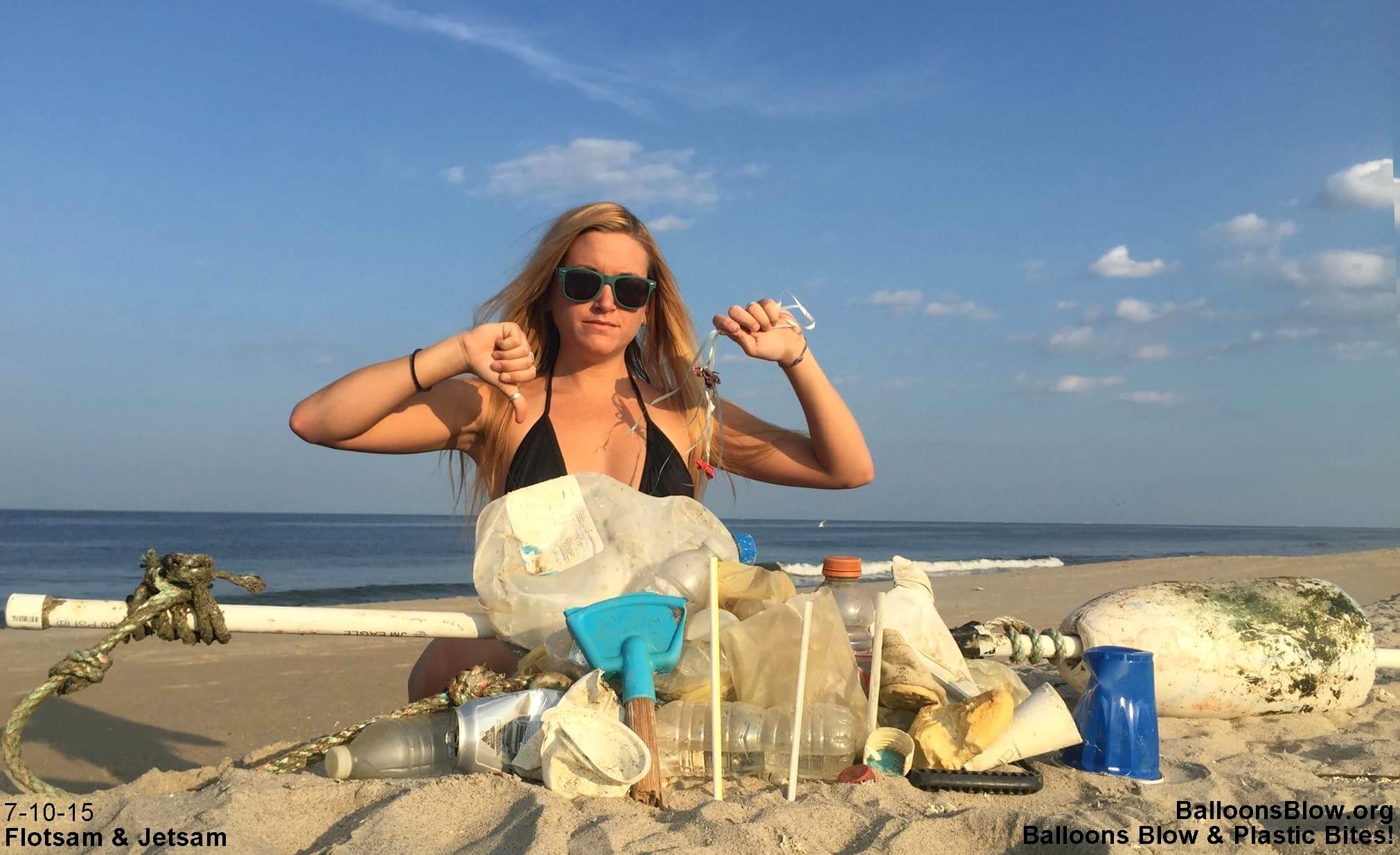
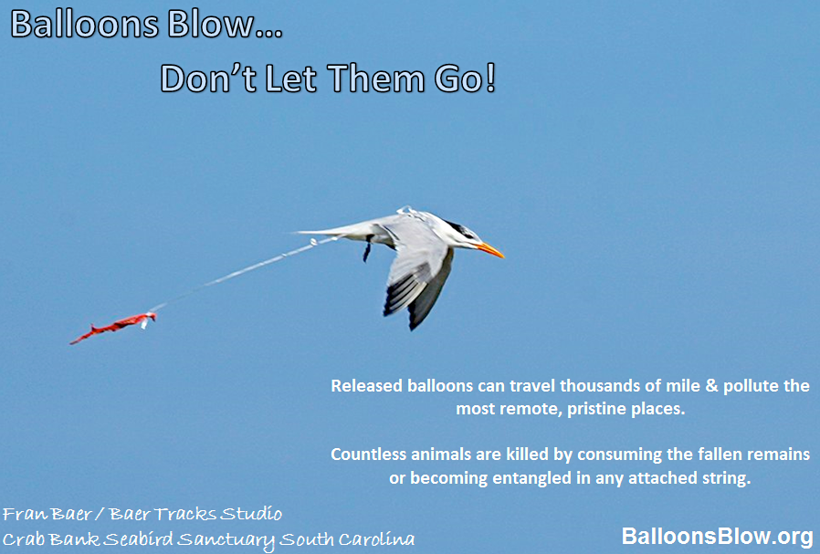
Elsewhere, some tackle the problems caused by particular types of trash, balloons being an excellent example. I have posted before about BALLOONS BLOW, the brainchild of two sisters who learnt of the serious consequences to wildlife caused by mass balloon releases. Their work has been so effective that increasing numbers of mass releases are being cancelled in favour of other forms of celebration. A minus for balloon-makers of course, but a big plus for wildlife. The BB sisters also keep their own beach clear of the junk brought in on every tide.
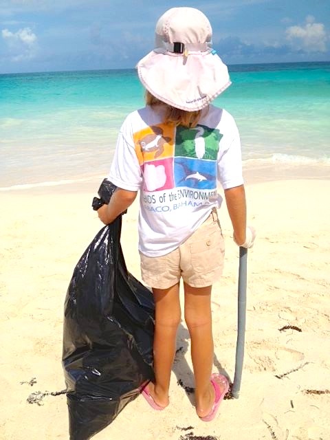
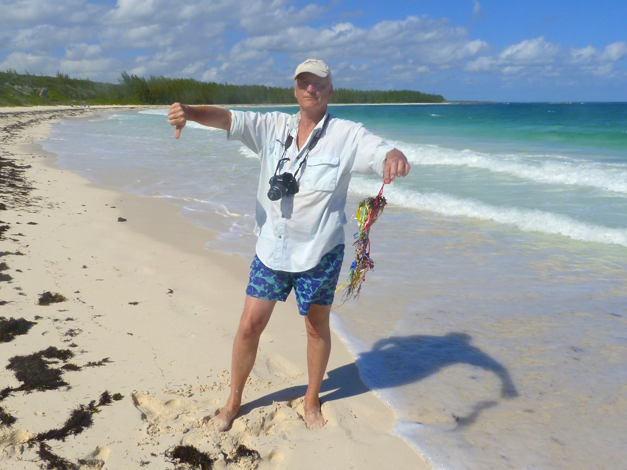
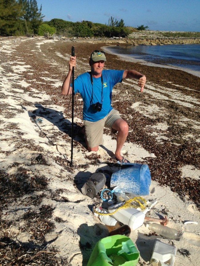
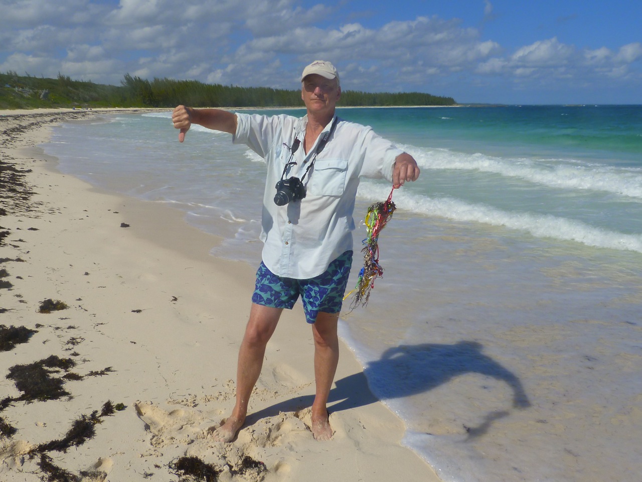
And on an individual basis, any old fool can make a tiny difference to a local beach. Here is one such doing just that…
A tangle of balloon strings on Delphi beach
Guinea Schooner Bay: little visited, rarely cleaned. Plastic crap from a 10 foot radius
MARINE DEBRIS: BALLOONS – WHAT GOES UP MUST COME DOWN…
Two sisters, Chelsea and Danielle, grew up by a Florida beach. With their parents,they learned from an early age to collect rubbish from the beach and to keep it clean. When they were little, the problems weren’t so great. Gradually, the tide changed. Literally. And indeed littorally. As is a common experience with any shoreline these days however remote and unspoilt, all manner of debris washes in on every tide, from plastic straws to SPACE ROCKET FAIRINGS. There has been a massive increase in ‘single-use’ plastic items. Most of it will take years, decades or even centuries to decompose. And there are deflated balloons, with their strings.
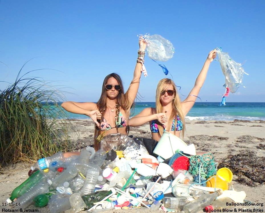
A typical haul of a lot of plastic and several balloons from just one beach collection
As ‘business’ on the Florida beach increased, so it became clear that balloons were becoming a significant problem. The increasing popularity of mass releases of balloons at sports events, civic or institutional occasions, and smaller celebrations means 100s or even 1000s of balloons being released into the sky. In most cases they are filled with helium – a finite resource – which carries them high over the earth. Very festive. Then the problems begin. They get caught in thermals, winds and crosswinds, gales and storms. Whether onto land or water, they all have to come down eventually. The problems caused therefore affect creatures inland, on the shoreline and out to sea.
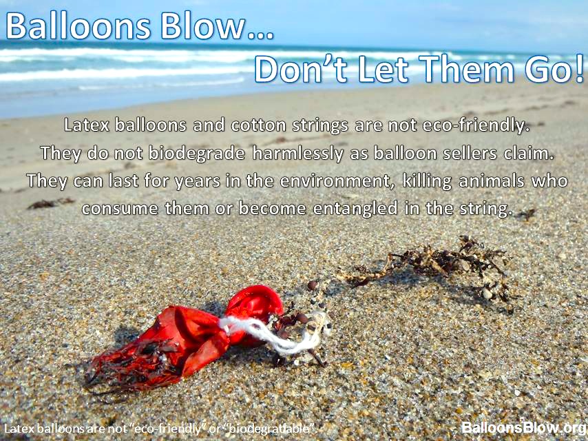
Eventually the sisters decided to take action. They started a website BALLOONSBLOW.ORG, linked to a FB page. They post regularly about their beach clean-ups, now extended to other beaches on the south-west coast of Florida. They also produce balloon-based information sheets and flyers such as these:
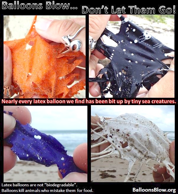
I have a folder in which I keep some horrific images of incapacitated, dying or dead creatures. I use them sparingly because in the main they are upsetting. Almost every one of them involves entanglement in or ingestion of such materials as plastic, mylar, styrofoam, rubber or latex. Here are just 3 examples involving balloon strings – I’ll spare you others I have collected (e.g. a turtle that died trying to excrete the remains of a balloon).
I don’t have a down on ‘fun’ – and nor do Chelsea and Lucy I’m sure. But, now in their 20s, they have had years of direct hands-on experience clearing their beach and one can see why they decided to take wider action. From one area they have accumulated a vast collection of balloons that will take many decades to break down. Even then, the degraded pieces and micro-pieces will be eaten by fish, turtles and birds.
Here’s an illustration of the problem of creatures nibbling away at latex
The Delphi beach is very regularly cleaned up, of course, but there’s nothing that can be done to stem the arrival of debris large and small on every tide. Beautiful and remote though the one-mile curved strand may be, one cannot walk far without seeing plastic of some description. As a matter of interest, I tried a test: walking south on the beach in the tide-line, how long would it take to find balloon evidence? The answer was, less than 10 minutes.
The decomposition rate of various common items
The Balloons Blow website is constructive in offering festive alternatives to mass balloon releases, rather than merely chronicling the downsides. The balloons and other plastic junk mostly arrives from the western fringes of the North Atlantic Gyre, in the Sargasso Sea, where the trash gets caught in the sargassum and is eventually forced onto the shoreline by currents, winds and tides.
North Atlantic Gyre hotspot infographic
This post has concentrated on the dangers to wildlife caused by latex and mylar balloons that are sometimes claimed to be biodegradable but are not. There’s more to be said about plastic marine trash, but I’ll keep that for another day.
MAPPING ABACO: READ A NOVEL, TALK RUBBISH OR DISAPPEAR
I am probably the last person to twig the topological significance of Abaco’s location in the world. An email tipping me off about a TV programme led me to investigate further. There turn out to be 3 ways in which Abaco’s position in the Atlantic Ocean is of special interest. Two are geographic fact; and one is located in the grey area between myth and putative evidence-based supposition (if such a nebulous concept exists…). If everyone knew this already, sorry for being so late into the game. But you get some nice maps to look at, gratis, like the wonderful van Keulen map of 1728 above. About the only marked location on Abaco is ‘Hole Rok’ (now ‘GAP ROK’). For a history of Hole-in-the-Wall in historic maps, click HERE
1. THE DISAPPEARING TRICK?
Until the recent email, I hadn’t taken on board that Abaco is within the Bermuda Triangle. The island and its cays are contained snugly into the 60º tip of the western angle of an equilateral triangle based on Bermuda, Miami and Puerto Rico. The NOAA map below could not be clearer: Abaco is squarely within the triangle, if that is geometrically possible.
I wrestled with whether to write an earnest discourse along the lines “Towards a Greater Understanding of Triangle Phenomenology”. Then I thought, Nah! If it’s a myth, what’s the point in examining its credibility. If it’s all true, I would’t want to worry you more than I already have by mentioning it… So you can do the hard graft if you wish by checking out the links below. Or you can just move on to section 2. Or relax in the sun, go fishing, find some nice birds, or have a Kalik or 3.
THE WIKI ANGLE Excellent potted overview dealing with supposed position, the main ‘unexplained disappearances’, and the possible causes of these – both natural and supernatural. Frankly, this should do it for all but the most persistent, who probably are more widely informed already.
SCIENCE CHANNEL The top ten Bermuda Triangle theories. Note: may not include your own pet theory of aliens from Planet Tharkron with their Pukotic Missile Rays
HISTORY.COMComes complete with spooky-music video presentation. NB blurb nails its colours to the mast by using words like ‘Mythical’ and ‘Fanciful’ so if you are a believer you won’t want to go here, I suspect.
TEN WEIRD FACTSAn informative video for those who want a bit more sensation.
2. WHAT A LOAD OF RUBBISH
Rowing through the Great Atlantic Garbage Patch (sandiego.surfrider)
Abaco also finds itself at the western edge of the Northern Atlantic Gyre. Strictly speaking the Gyre comprises a combination of four main currents: the Gulf Stream in the west, the North Atlantic Current in the north, the Canary Current in the east, and the Atlantic North Equatorial Current in the south. It is not synonymous with the infamous North Atlantic Garbage Patch, which is contained within the geographical boundaries of the Gyre. The top image gives a broad-brush idea of the central area of concentration of the Garbage Patch within the Gyre. Abaco looks to be well clear of trouble. But don’t be too optimistic.
North Atlantic Garbage Patch (12Degreesoffreedom)
Looking at various sources, there is some variation in the precise boundaries of the Gyre, though Abaco is plainly within it. Q: is it safely beyond the edges of the plastic peril? A: as any resident will know, the naturally pristine beaches tell a tale of constant plastic and other debris brought in on the high tide almost daily. The incidence depends to an extent on weather and wind direction, but the overall picture is of a relentless intrusion of rubbish on golden and white sand expanses. There is an extent to which what the tide giveth, the tide taketh away; and of course many beaches are scrupulously kept clean. NB I’m not trying to propagate anti-visitor publicity – many people will have experienced the same situation elsewhere.
North Atlantic Gyre Garbage Patch (wired.com)
The research map above shows that, although the garbage hotspots and warmspots are well away from Abaco, the ever-widening circulating soup of plastic, rubber and metal has reached the island. Abaco is in the pale blue zone. Yellow is not that far off. Imagine what the orange or red areas must be like. This sort of thing:
In some places the junk stacks up to form islands with hills
Texas has become a standard ‘unit’ for large area comparisons. I notice that several sources describe the main area of the NA Garbage Patch in terms of Texas. But how big is that (BIG!)? To get an idea, I created a map overlaying Texas on an area centred on the Bahamas. So, Texas is this big…
I’ve got more about some very specific rubbish to discuss another time, so I’ll leave you with the most interesting piece of marine debris to wash up on the Delphi Beach, a 12 ft ROCKET FAIRING from the Mars ‘Curiosity’ launch! Click link for more details.
3. A NOVEL PLACE TO BE?
The Sargasso Sea is named for theSARGASSUMseaweed found in large concentrations in the area. Columbus was the first person to sail right across the Sea, in 1492 (well, he and the crews of his 3 ships Niña, Pinta, and Santa Maria). He noted the large areas of seaweed that his expedition’s ships had to plough through. Eventually he made landfall on San Salvador, Bahamas.
This fine Krümmel map from 1891 shows the extent of the sea, and you’ll see that its western fringes reach the ocean side of Abaco. Have you seen the seaweed pictured below the map? That’s Sargassum.
Sargasso See Map – Krummel -1891
A close-up of Sargassum – maybe it washes up on a beach near you…
EIGHT FACTS ABOUT THE SARGASSO SEA TO IMPRESS YOUR FRIENDS
Jean Rhys’s famous 1966 novel ‘The Wide Sargasso Sea’ is actually set in Jamaica (nb the Sea is mentioned!)
The Sargasso is the only ‘Sea’ to have no land boundary, being entirely in the Atlantic Ocean
It is vital to mass migrations of eels, where they lay their eggs
Young loggerhead turtles are believed to head for the Sea for seaweed protection while they grow
Much of the debris trapped in the NA Garbage Patch is in the Sargasso, and is non-biodegradable plastic
The Sea is protected by Commission established in 2014 involving at present 5 countries, including (unbelievably) Monaco, the second smallest country in the world at 0.75 sq miles. Green Turtle Cay is about twice the area!
Cultural references include the track “Wide Sargasso Sea” on Stevie Nick’s “In Your Dreams” (2011)
There are loads of other literary & musical references but I lost the will to pursue them when I saw the inclusion of ‘Dungeons & Dragons’
If you want to find out more about Jean Rhys’s novel, read it or clickHERE
MUSICAL DIGRESSION
While writing this post I have had a song thrumming annoyingly inside my head. It’s ‘Bermuda Triangle’, with its coyly rhyming ‘look at it from my angle’. Now it’ll be inside your head too! I couldn’t remember who it sang it. Rupert Holmes? No, that was the egregious “Escape (The Piña Colada Song)” (1979). Ah yes. Barry Manilow. Bazza Mazza. The Bazzman. As you’ve finished with the maps etc, here’s a musical memory with a counterbalance of the Stevie Nicks song mentioned earlier…
Those cover the Triangle and the Sargasso; what of the Garbage? Try some Fresh Garbage from Spirit…
OPTIONAL MUSICAL NOTES Randy California’s fingerpicked intro to ‘TAURUS‘ is remarkably similar to the later, far more famous guitar work of Jimmy Page’s intro to ‘STAIRWAY TO HEAVEN‘. And Spirit happened to tour with the early Led Zep. Legal action was commenced last year for copyright infringement, as yet unresolved… You be the Judge!
Credits: As credited above; open source; NOAA; mail.colonial; telegraph.co.uk; Sandy Walker;Bogdan Giușcă, Youtube self-credited; Wiki; Random Researches and Magpie Map & Fact pickings


You must be logged in to post a comment.