Unknown's avatar

BREADFRUIT: NATURE’S BOUNTY (WITH ADDED MUTINY)


Artocarpus altilis - breadfruit (Hans Hillewaert)

BREADFRUIT: NATURE’S BOUNTY (WITH ADDED MUTINY)

Capt. William Bligh achieved fame for all the wrong reasons. Despite a distinguished and wide-ranging seafaring career he is widely remembered for just two things: (1) The Bounty and (2) Mutiny On. In 1787, he was dispatched to Tahiti to collect specimens of breadfruit (a fruit of the Pacific islands, in particular Polynesia) to help provide food for the British colonies in the West Indies. To be clear, the breadfruit was intended to be a basic and cheap staple food not just for settlers but also for the indigenous population.Breadfruit 2

Capt. Bligh’s Bounty crew unfortunately mutinied – possibly to do with the amount of water the breadfruit required compared to their own meagre rations – and threw overboard the hundreds of breadfruit plants that were in transit. Then they set Bligh with his loyal officers and crew adrift… He was later court-martialled but cleared of culpability for the mutiny. 

Mutiny on the HMS Bounty (Robert Dodd)

This isn’t the place for a disquisition on the Mutiny. You can read all about it HERE. Or better still, watch one of the rollicking all-star-cast films based loosely on the episode for a careful and accurate historical record of the events that will buckle your swash…

Mutiny_on_the_Bounty_Poster (1935)     220px-Poster_for_Mutiny_on_the_Bounty

Following that skirmish, and indeed blemish on his record, in 1793 Capt. Bligh was yet again charged with the task of shipping breadfruit trees from their origin to the Caribbean. His heart must have sunk, yet finally he succeeded, only for those on the eating end to express considerable distaste for such a bland, starchy fruit. It took a long time to catch on, and its culinary versatility was only discovered many decades later. By which time slavery had thankfully been abolished anyway.Breadfruit image (Pacific site)

The most famous breadfruit tree in all Abaco is to be found in Hope Town (Elbow Cay). I can do no better than display the notice that proudly proclaims the historic significance of the tree; and of course the tree itself.

Breadfruit Tree Notice, Hope Town Abaco (Dp PatersonBreadfruit Tree, Hope Town Abaco (Dp Paterson)

Unusually for a fruit plant, a true breadfruit Artocarpus altilis does not produce seeds. It is propagated by removing the suckers that grow at at the base of the tree.

For those unfamiliar with the fruit and its interior, here it is in both slice and cross-sectionBreadfruit sliced (US Pacific Basin Agricultural Research Center)

BREADFRUIT IN ART

Breadfruit has received artistic recognition over the years. Here are some examples – the first, very jolly (and an early representation of the Polydamus Swallowtail butterfly, I think); the second, quite dull; the third, instructional (oddly equating breadfruit with tea, coffee and chocolate); and the fourth, frankly not at all appetising to look at…

Breadfruit with butterflies (Royal Botanic Garden, Kew)Breadfruit (Royal Botanic Gardens, Kew)

                                 Breadfruit (John Frederick Miller)                                  Breadfruit drawing  John Frederick Miller

      Breadfruit & related plants used as food (William Rhind (1841)     Breadfruit etc William Rhind (1841)

Breadfruit - Bahamas Stamp

WORLD DISTRIBUTION OF BREADFRUIT

Breadfruit will flourish only within a certain latitude range where the rainfall and temperature suit it, as this map shows. I include this information in case you ever find yourself in the awkward position of being socially stranded with someone whose conversation has become soporific. Be armed with some useful worldwide breadfruit stats for just such an occasion – you will soon find yourself alone…Breadfruit - the world propagation range

A CULINARY TREAT

Breadfruit is sometimes thought to be a dull and untasty, at least compared with many other fruits. I thought I’d include a recipe or two that rather appealed to me – the second because even I could do that…

Breadfruit Recipe  (myrecipefriends.com)

BAKED BREADFRUIT

Large, ripe breadfruit 1 cup water Butter 1 lime or lemon

Heat oven to 33 degrees F. Put the water in a shallow pan and place the whole breadfruit in the water. Bake in oven for three hours. Remove from oven, allow to cool slightly, peel, removing the large core and stem. Cut the fruit into sections and place in a serving dish. Cover with butter and a squeeze of lime or lemon juice.

A PERFECT HOPE TOWN BREADFRUIT
Breadfruit, Hope Town Abaco (Dp Paterson)

This post was inspired by an article on breadfruit and the Hope Town tree by local historian Deb ‘DP’ Patterson, who will be known to many for her committed involvement with the Wyannie Malone Historical Museum in Hope Town. I’m grateful to her for permission to use her idea and indeed some of her material, in particular her photos of the tree and its notice. If you do visit this delightful little town, the museum is a treasure house of Abaconian history that deserves a visit. You can check out its website HERE and the FB page HERE.

Wyannie Malone Museum Crest, Hope Town, Abaco

Capt. Bligh managed to put his breadfruit adventures and the mutiny behind him, and continued a distinguished naval career with successive command of an impressive number of  ships. He ended up a Vice-Admiral, and (on his death in 1817) in a grave in Lambeth, London.

V-A William Bligh (1814)Grave of William Bligh, Lambeth, London (Geograph, Commons Media

HMS BOUNTY II (Full Sails). A 1960 reconstruction (Dan Kasberger)HMS_BOUNTY_II_Full_Sails 1960 reconsrtuction (Dan Kasberger)

Credits: First and foremost, Deb Patterson; Magpie Pickings including Hans Hillewaert, US Pacific Basin Agricultural Research Center, Royal Botanic Garden Kew, myrecipefriends, M Kwek, whatsonbahamas, Wyannie Malone Historical Museum, ‘Geograph’, Dan Kasberger, and Wiki; and anyone else I have omitted…

Unknown's avatar

ELBOW REEF LIGHTHOUSE, ABACO: THE OLD LADY’S BIG DAY


Hope Town Lighthouse, Elbow Cay, Abaco

ELBOW REEF LIGHTHOUSE, ABACO: THE OLD LADY’S BIG DAY

There are various overwrought ‘describing’ words that have become devalued and tired through overuse. Unique. Unsurpassed. Unparalleled. Iconic. However the famous and much-loved Elbow Cay Lighthouse could plausibly lay claim to any one of those adjectives. Let’s make that ‘all’. Earlier this year, following a meticulous survey, repairs and refurbishments were made to this stately 89 foot high, 101 step light that came into operation in 1863 during the height of the American Civil War. 

You can read more about the lighthouse, its importance and its machinery in various earlier posts (use the search box), and there is other material including details of the recent repair program HERE. This post is simply to advertise the forthcoming 2nd Lighthouse Festival that takes place in Tuesday June 23rd. The flyer below tells you all you need to know about the day.

11165251_902234616503783_3983866159670923203_n

For this event, the students of Hope Town Primary School, in conjunction with the invaluable ELBOW REEF LIGHTHOUSE SOCIETY , have produced a wonderful book celebrating the lighthouse, with proceeds of sale benefitting the school’s volunteer programs and the Society’s ongoing projects. I am sure will be a best seller – make it happen!

10986656_10153399883840815_3126863414253161396_n11140378_10153399883870815_873890178916274603_n

As last year, the events will include an auction. Among the wide variety of items to be auctioned will be a 15″ x 15″ print on canvas of my photo of a Western Spindalis, taken on the drive of the Delphi Club and included in “THE BIRDS OF ABACO” (a copy of which was auctioned last year). 

Western Spindalis, Abaco (Keith Salvesen)

Maybe a few more pics of such an interesting building are called for…. And a reminder of some key words to scatter liberally into your conversation at the event. Or anywhere, really: “Fresnel Lenses”, “Mercury Bed”, “Clockwork Mechanism”, “Trinity House, London”.Hope Town Lighthouse, Elbow Cay Abaco

Hope Town Lighthouse, Elbow Cay, Abaco (Lamp, Fresnel Lens) hoplit22 Hope Town Lighthouse, Elbow Cay, Abaco hoplit20 Hope Town Lighthouse, Elbow Cay, Abaco hoplit19 Hope Town Lighthouse, Elbow Cay, Abaco hoplit18 Hope Town Lighthouse, Elbow Cay, Abaco hoplit17 Hope Town Lighthouse, Elbow Cay, Abaco (Fresnel Lens) hoplit6 Hope Town Lighthouse, Elbow Cay, Abaco hoplit4 Hope Town Lighthouse, Elbow Cay, Abaco hoplit2 Hope Town Lighthouse, Elbow Cay, Abaco hoplit3

And finally a wonderful photo of Hope Town centred on the Lighthouse complex. Enjoy June 23rd.Elbow Reef Lighthouse Society

Logo of the World Lighthouse Society

Logo of the World Lighthouse Society

Credits: Lighthouse exteriors and Spindalis RH; all interiors Mrs RH; props to Elbow Reef Lighthouse Society (and ?David Rees for the aerial view…); Annie Potts for her inspiring book “Last Lights” about the intriguing lighthouses of the Bahamas

Unknown's avatar

HOLE-IN-THE-WALL, ABACO: A UNIQUE PERSPECTIVE (2) PRESENT & FUTURE


Winslow Homer G W Original Brooklyn

HOLE-IN-THE-WALL, ABACO: A UNIQUE PERSPECTIVE (2) PRESENT & FUTURE

Following on from my post last month HOLE-IN-THE WALL: THE PAST, it’s time to take a closer look at the ‘Gap-in-the-Wall’ as it is today, viewed from the sea. I’ve called this a ‘unique perspective’, but I’m sure many people have taken photos of HITW from the sea. It just that apart from a few kayaking ones from before the collapse of the arch, I haven’t found them. So I took some, thanks to the BMMRO and their research RHIB. 

Hole-in-the-Wall Abaco (2015-2) 01 Location photo map

The view above is taken from some way to the west of HITW, and I have marked the main features that will be shown in this post. As one approaches the promontory, the lighthouse and its outbuildings are the only sign of human intervention to be seen in the landscape. Historically there were small settlements in this remote place, and some traces of these remain.

Hole-in-the-Wall Lighthouse Abaco (sea view)

Closing in on the former ‘Hole’, fresh damage from Hurricane Sandy’s destruction of the arch is still visible. It is more conspicuous on the other side.Hole-in-the-Wall Abaco (2015-2) 03 Collapsed arch (Hurricane Sandy)

In this photo, you can follow the features from the lighthouse to the foreshortened promontory, the new gap, the small islet that now exists, and finally a small eroded outcrop of rock – the remains of an extension of the mainland, and probably evidencing the southern tip of another arch that collapsed centuries ago.Hole-in-the-Wall Abaco (2015-2) 04 Light, hole and outcrop

Passing the outcrop and round to the east side of the promontory, further evidence of fresh damage can be seen, with the main shear being on the north side of the arch.Hole-in-the-Wall Abaco (2015-2) 05 Hole-in-the-Wall Abaco (2015-2) 09Hole-in-the-Wall Abaco (2015-2) 07Hole-in-the-Wall Abaco (2015-2) 10

There’s a fine view of the lighthouse from the east Hole-in-the-Wall Abaco (2015-2) 11

As we started the return journey to Sandy Point via groups of whales and dolphins, we went close to the outcrop, land’s end (next stop, Nassau). Even on a calm day, it is still thrashed by waves, as the second photo shows: no wonder it has eroded so quickly…  See how it looked in the 1803 aquatint below, from which one can see how there must have once been an even larger ‘hole in the wall’ way back in history and long since collapsed even by then. Hole-in-the-Wall Abaco (2015-2) 12 Hole-in-the-Wall Abaco (2015-2) 13Hole in the Wall Print 1803

Then it was time to move on, having been fortunate enough to see the location from an entirely new angleHole-in-the-Wall Abaco (2015-2) 14Hole-in-the-Wall Abaco (2015-2) 15

THE FUTURE

The geological future of the Hole-in the-Wall landscape is presumably that erosion and rising sea levels will sink the outcrop below the waves; the islet left after the collapse of the arch will similarly erode over the centuries, as in time will the whole promontory. Maybe as it gets thinner, another hole will be worn through by the waves. The restoration of the lighthouse, long promised, may perhaps take place. The nautical importance of the area suggests that the historic need for a light as both landmark and warning will continue. And who knows: even now, plans for wholesale redevelopment of the area could be on a drawing board somewhere…

Hole-in-the-Wall Lighthouse Abaco (Notice) hitw9

WINSLOW HOMER

The header image is the well-known watercolour by Winslow Homer (1836 – 1910), the original of which is in the Brooklyn Museum. It was painted in 1885 and is entitled ‘Glass Windows’. This is commonly claimed to be the famous ‘Glass Window’ feature on Eleuthera. However my own theory is that it in fact depicts Hole-in-the-Wall, Abaco. There are a number of good reasons for this, but the most immediately striking is the title Homer himself gave to an engraving of the identical view, published in The Century magazine (Feb 1887). This engraving pre-dates, and was clearly the template for, the watercolour. The rock structure and even the cloud formations are identical. And the title “On Abaco Island” seems conclusive of the location.

Hole-in-the-Wall Picture

Credits: All photos, RH; Winslow Homer painting, Brooklyn Museum online archive

Unknown's avatar

‘RALPH’S OLD BAT’: ABACO’S ASTOUNDING UNDERGROUND CAVES (5)


Ralph's Cave, Abaco (Brian Kakuk) 15.5 : 4

‘RALPH’S OLD BAT’: ABACO’S ASTOUNDING UNDERGROUND CAVES (5)

It’s time to revisit the wonderful caves that lie below the landmass of Abaco. Unknown to many, there are parts of the island where below your feet are huge networks of caves and tunnels packed with beautiful crystal and mystery. I lack any of the necessary qualifications to explore these for myself (some serious equipment including camera, ability to swim properly, and courage) but thanks to diving exert Brian Kakuk, my own deficiencies are irrelevant…

Ralph's Cave, Abaco (Brian Kakuk) 15.5 : 3

Two caves in particular, Ralph’s and Dan’s, are rich in exotic crystals, stalactites and stalagmites. They can be found close to each other on South Abaco, deep in the pine forest. All images here are from Ralph’s cave, one of several cave / blue hole complexes that are soon to form part of the South Abaco Blue Holes Conservation Area (boundaries shown in fig. 1). Rolling Harbour (where the Delphi Club is situated) is the curved bay to the bottom right corner, under the acronym GEBCO

Abaco caves map jpg Abaco Caves Ralph & Dan jpg

Apart from the amazing sight of the cave chambers themselves, the details of the crystal formations – often geometric -are remarkable close-to. Here are 3 examples that demonstrate how they range from strong-looking structures formed over millennia to the most delicate forms such as in the third image that appear to be made from fine fabric.

Ralph's Cave, Abaco (Brian Kakuk) 15.5 : 1 Ralph's Cave, Abaco (Brian Kakuk) 15.5 : 2 Ralph's Cave, Abaco (Brian Kakuk) 15.5 : 5

And if you wondering about the title of this post, this is the reason: Brian discovered a bat, believed to be at least 13,000 years old, entombed in crystal – not so much a fossilised bat as a crystallised bat… In other caves (at the Sawmill Sink blue hole for example), fossilised bones have been found, including of a prehistoric species of crocodile that must have lived on the island many thousands of years ago. This is the first crystallised creature I have ever seen… I am checking with Brian whether he has seen anything else quite like it during his explorations.

Ralph's Cave, Abaco (Brian Kakuk) 15.5 : 6 Ralph's Cave, Abaco (Brian Kakuk) 15.5 : 7

Credits: all images by Brian Kakuk, with thanks as ever for use permission; all crystal by magic; preserved bat by gradual accretion

Unknown's avatar

HOLE-IN-THE-WALL, ABACO: A UNIQUE PERSPECTIVE (1) THE PAST


Map of Abaco (part) - van Keulen 1728

HOLE-IN-THE-WALL, ABACO: A UNIQUE PERSPECTIVE (1) THE PAST

I’ve posted several times about the desolate, unpopulated area on the southern tip of Abaco known as Hole-in-the-Wall. It’s a place of history and mystery – indeed arguably the most historically, geographically and nautically important location on the entire island. The material in this post has to an extent been combined from earlier posts a couple of years back, since when a great many more people have been showing an interest in the wildlife and history of Abaco (thanks!) and may be new to the history and significance of HITW…

Although Abaco is identifiably – though not geographically reliably – mapped from as early as 1550 (only 58 years post-Columbus), the earliest map of Abaco showing any actual named place is the van Keulen map of 1728 in the header picture. The importance of HITW (‘Hole Rok’ marked on the east side) is clear. Indeed it is the only settlement shown. Thereafter, the place is mapped variously as Hole-in-the-Rock, Trou dans la Roche and Hole-in-the-Wall, before finally settling on the last name. HITW was clearly a significant nautical landmark from at least the c16. You can read more on this topic at HITW – A SHORT HISTORY IN MAPS

Incidentally, note the early spellings including of the word ‘Cay’ as ‘Kee’ in the bottom right corner – doubtless an explanation for the pronunciation today, when one might otherwise rhyme the word with ‘Bay’.

hole-in-the-wall-print-1803

The print above, dated 1803, is the earliest depiction of HITW that I have traced. For now, note the familiar ‘Hole’ between the two ships; and the outcrop to the right showing that another, larger ‘Hole’ had, by the early c19, collapsed. Remains of the outcrop, now badly eroded, can still be seen. Read more about pictures of HITW in SHIPS, MAPS & HITW , or in HOLE TO GAP, including a more recent print by Winslow Homer (below) which I contend is the proof that his famous painting ‘Glass Window’ in the Brooklyn Museum is of Abaco and not (as claimed elsewhere) the famous Glass Window on Eleuthera. Of which more another time…

Hole-in-the-Wall Picture

The sad fact is that although the name lives on and probably always will, in October 2012 Hurricane Sandy smashed the Hole in the Wall to smithereens, leaving what one can best describe as GAP IN THE WALL.

Here is the position of the Hole, shown before Sandy struck. Note the outcrop at the tip (bottom right corner), as seen in the old print above hole-in-the-wall-rock-abaco-location

One of very few photos taken from the sea that I have come across. There’ll be more, and much closer, in the next post Hole-in-the-Wall distance shot

The view from the lighthouse down to the ‘Land’s End’ promontory (RH)Hole-in-the-Wall Lighthouse Abaco (Keith Salvesen)

An aerial view of ‘Land’s End’ (with thanks to marinas.com for free use permission)Hole-in-the-Wall Lighthouse, Abaco annotated

The Hole, very shortly before Hurricane Sandy blasted away the bridge – the perfect place for a picnic…Hole-in-the-Wall Abaco ©Jessica Arrington

Or, as the storm approaches, maybe not…. Jack Bowers took this wonderful (and dangerous to acquire) sea-level shot – possibly the last photo ever of the intact arch427937_4820129308023_1041770732_n

Photos of the ‘Ex-Hole Now Gap’ taken within a very few days of the storm. Note the pale fresh stone HOLE-IN-THE-WALL ABACO post Sandy 1 Luc LavalleeHOLE-IN-THE-WALL ABACO post Sandy 2 Luc LavalleeHOLE-IN-THE-WALL ABACO post Sandy 3 Tara Lavallee

This post covers the history of Hole-in-the-Wall over the last 400 years or so, with links to earlier posts from a couple of years back. Then there’s a bit of a gap, I’m afraid, back to the LATE PLEISTOCENE EPOCH roughly 125,000 years ago when the landmass was formed… 

PART 2 will show how the ‘Hole’, the promontory and the lighthouse now look in 2015 from the ocean. During a recent highly successful whale-watching expedition with Charlotte & Diane from the BMMRO, we took the RHIB close to the point and took a seaward look at it from both sides, the first time I had done so. A few days before we’d been to Hole-in-the-Wall for birdwatching purposes by conventional means – the thirty mile round trip by truck along the track from the ‘Y’ of the Highway (NB no hire cars allowed). You can read an early post about this perilous adventure in TO THE LIGHTHOUSE…

HOLE-IN-THE-WALL LIGHTHOUSE: THE LANTERN ROOMHole-in-the-Wall, Abaco - Lantern Room (Keith Salvesen)

Credits: S. Wright, RH, marinas.com, Jessica Arrington, Jack Bowers, Luc Lavallee, Tara Lavallee, open source images

Unknown's avatar

ABACO’S FORGOTTEN LIGHTHOUSE: THE “OLD LIGHTHOUSE”, LITTLE HARBOUR


ABACO’S FORGOTTEN LIGHTHOUSE: THE “OLD LIGHTHOUSE”, LITTLE HARBOUR

Little Harbour Abaco, Aerial View -Simon Rodehn annotated

Little Harbour Abaco, Aerial View (Simon Rodehn)

There’s relatively little that a casual investigator can discover about the ruined lighthouse at Little Harbour, Abaco. This hurricane-damaged wreck is Abaco’s third and largely unknown light, after the icon on ELBOW REEF and the desolate but romantic HOLE-IN-THE-WALL that stands on the southern tip of Abaco, down 15 miles of dodgy track through the National Park. Two specific sources of information begin our tour of the “Old Lighthouse at Little Harbour.

Extract from ROWLETT LIGHTHOUSES OF THE BAHAMAS

“LITTLE HARBOUR Date unknown (station established 1889). Inactive. Ruins of a 1-story concrete keeper’s quarters, known locally as the “old lighthouse.” A modern steel framework tower carried an active light until it was blown over by Hurricane Sandy in October 2012; Trabas has Darlene Chisholm’s photo of the toppled light. A photo and a very distant view are available, and Bing has a satellite view. In an aerial view of the harbor, the light is on the peninsula at upper right. Located at the entrance to Little Harbour, about 25 km (15 mi) south of Marsh Harbour, Great Abaco Island. Accessible by a short walk to the end of the peninsula sheltering the harbor. Site open, tower closed. Site manager: unknown. ARLHS BAH-021; Admiralty J4576; NGA 11808.”

The “Old Lighthouse” – Little Harbour, Abaco

Abaco Escape  – Sandy Estabrook’s essential GUIDE TO THE ABACOS

Often overlooked is (or should we say was) the “Old Lighthouse” as it is called. It was established in 1889 at the entrance to of Little Harbour channel, the southern entrance to Abaco Sound. Once it was a manned light, with the lighthouse keeper and his wife being the only inhabitants of Little Harbour. Of course the keepers are long gone and so is most of the house. The light tower was converted to solar in modern times but was dealt a devastating blow by Hurricane Floyd in 1999. Access is via a path which starts from the shoreline and winds up the hill through seagrapes and bush. Few people venture up here these days. If there is a big ocean swell running, walk down to the cliff top in front of the lighthouse, where you’ll find a blowhole known as the Dragon. Depending on swell height, it could be roaring, snorting and shooting out clouds of spray. Sandy Estabrook

Photos referenced by Rowlett  – see extract above

Note the steel frame tower on the right, a structure replacing the old light destroyed by Hurricane Floyd in 1999; and itself toppled by Hurricane Sandy in 2012

A GALLERY OF RECENT IMAGES

Lighthouse ruins, Little Harbour Abaco, Patrick Shyu

Lighthouse ruins, Little Harbour Abaco, Patrick Shyu. The only interior shot I could find. Note the fallen steel tower (2012) (and seen from the outside below)

Lighthouse ruins, Little Harbour Abaco - Patrick Shyu

Lighthouse ruins, Little Harbour Abaco – Patrick Shyu

Little Harbour lighthouse Abaco - Darlene Chisholm

Little Harbour lighthouse Abaco, post Hurricane Sandy – Darlene Chisholm

Little Harbour Lighthouse Ruins, Abacos - MV Shingebiss

The Old Lighthouse ruins, taken during a cruise (MV Shingebiss)

LOCATION

In the header image, the location of the Light, looking very roughly north, is shown as a grey pimple on the eastern peninsula that forms the Little Harbour bay. There is no other building in this area. Below are some additional aerial maps showing the path to the Light and its relative remoteness. It is not covered in the wonderful book on Bahamas lighthouses by Annie Potts entitled “Last Lights” (2011, Fish House Press). I surmise that this small Light was more of a beacon to pinpoint the location of the entrance to Little Harbour, and perhaps to enable triangulation with the large lights at ELBOW REEF and HOLE-IN-THE-WALL.

Little Harbour Lighthouse 1 jpg copy

Little Harbour Lighthouse 2 jpg

An unusual aerial view of Little Harbour Lighthouse from the north, showing the path to it. You can see the ‘modern steel framework tower’ referred to in the ROWLETT entry above, replacing the original lighthouse tower destroyed by Hurricane Floyd and later toppled by Hurricane Sandy.

Little Harbour Lighthouse Marinas.com

Little Harbour lighthouse Marinas.com

Credits:  Simon Rodehn (LH aerial view – thanks again!), Rowlett’s Lighthouses, Sandy Estabrook / Abaco Escape, Wiki Map, Patrick Shyu, Darlene Chisholm, MV Shingbiss, marinas.com

Unknown's avatar

ELBOW REEF LIGHTHOUSE, HOPE TOWN, ABACO: 150 YEARS OLD TODAY!


HT Lighthouse 1

HOPE TOWN LIGHTHOUSE ABACO: THE WORKS

ELBOW REEF LIGHTHOUSE, as it is properly called, is 150 years old. It is the stripy icon of Abaco – and quite flashy as well. One of the last remaining kerosene-lit lighthouses in the world, it retains its mechanisms and fresnel lenses in remarkable condition, a tribute to the conservation lovingly devoted to the building. Below is a re-post of an article I wrote some time ago, with photos of some of the internal works and some facts and figures thrown in, There’s a big event in the lighthouse’s honour today – here’s the flyer for it. We’ve donated a signed copy of “The Birds of Abaco” for auction, and I hope it makes a few $$$$ for the cause.

photo copy

Bahamas Lighthouse Pres Soc Logo     Bahamas Lighthouse Pres Soc Logo    Bahamas Lighthouse Pres Soc Logo    Bahamas Lighthouse Pres Soc Logo    Bahamas Lighthouse Pres Soc Logo

Hope Town Lighthouse, Abaco

Our visit to Elbow Cay was one part of our day’s Island Hopping / Reef Snorkelling expedition with Kay Politano. In Hope Town, while most of the party wandered round the streets (and shops…) Mrs RH took the boat across the harbour to the Hope Town Lighthouse. This must be the best known landmark of Abaco – ‘iconic’, perhaps, in the modern sense of the word. The weather on the day was pretty poor, with thick cloud and intermittent rain and drizzle. Which is a pity, because the photos would have looked even better with sunshine and blue sky… 

                                          All photos: Mrs Rolling Harbour


HOPE TOWN LIGHTHOUSE FACTS

(CLICK  on Coordinates below for position and Hope Town info)

Location: Elbow Cay, port of Hope Town
Coordinates 26.539421°N 76.958840°W
Year first constructed: 1862
Year first lit: 1864
Construction: Masonry
Tower shape: Conical
Markings/Pattern: Red and white bands
Focal Height: 37 m (121 ft)
Original lens: First order Fresnel
Range: 23 nmi
Characteristic: Fl(5) 15s
Admiralty number: J4572
NGA number: 11800
ARLHS number: BAH-010

THE HOPE TOWN LIGHTHOUSE is one of only three Manual Lighthouses left in the World. It has a spring mechanism that has to be hand cranked every few hours to maintain the sequence of five white flashes every 15 seconds. The lamp burns kerosene with a wick and mantle. The light is then focused as it passes through the optics of a first order (largest size) Fresnel lens which floats on a bed of mercury.

A FRESNEL LENS (pron. ‘Fray-nel’) is a type of lens originally developed by a French physicist Augustin-Jean Fresnel specifically for lighthouses.Compared to conventional bulky lenses, the Fresnel lens is much thinner, larger, and flatter, and captures more oblique light from a light source, thus allowing lighthouses to be visible over much greater distances. Fresnel’s lighthouse lenses ordinarily fell into six orders based on their focal length, first order being the largest (wiki-assist)

For some more images of this iconic – or do I mean symbolic (discuss) – building CLICK===>>> ILOVEHOPETOWN You’ll find that around half the images are of the lighthouse, internal and external. Then look at the colourful remainder. Then it’s a short step to the Facebook page and more info about this charming Cay

Logo of the World Lighthouse Society

Unknown's avatar

MARSH HARBOUR ONLINE MUSEUM: A NEW RESOURCE FOR OLD ABACO


Marsh Harbour, Abaco - Old Photo

MARSH HARBOUR ONLINE MUSEUM: A NEW RESOURCE FOR OLD ABACO

There’s a new arrival on Facebook, and the word is already out. Within 12 hours the page has gained 119 followers*. Already there are some wonderful old photos of family groups and MH residents. Some are named; some may be waiting for someone to recognise them. The header image (thanks for use permission, MHOM) is both instantly recognisable yet puzzling. Is that Snappas over there… no, look, there…? To get straight to the page, click HERE. I guess they’ll want to hear from anyone who has old photos or postcards of MH; or who can help with ID of people and places.

cropped-option-7-copy

There is a similar resource for GREEN TURTLE CAY, where Amanda has a great blog LITTLE HOUSE BY THE FERRY. In part it records the restoration of her family home. However, it is also packed with old photos (with people invited to name the unknowns) and details of a fascinating genealogy project through DNA samples. MAN-O-WAR CAY has a Facebook Group called Man-o-War Cay and Abaco Family History with similar aims. HOPE TOWN has a very active Facebook page fronted by the iconic LIGHTHOUSE. And so on. Not forgetting the museums such as the WYANNIE MALONE MUSEUM, Hope Town and the MAN-O-WAR CAY HERITAGE MUSEUM.

‘Elbow Reef’ – antique engraving Hope Town Abaco - historic print

I am neither Abaconian nor even a second-homer, so I tread lightly in these matters for obvious reasons. However, I have posted a few items about Abaco’s history from time to time so I’ll add a few links below in case anyone is tempted to investigate further. Meanwhile, I notice that in the time I have put this post together, the followers for MHOM have risen to 139…

ABACO HISTORY: SHIPS, MAPS & HOLE-IN-THE-WALL

CHARLES CORY’S C19 BIRDING EXPEDITIONS TO ABACO

“GLIMPSES OF LIFE ALONG A CORAL REEF” A c19 NATURALIST VISITS ABACO

MAN-O-WAR CAY, ABACO: THE HIDDEN BOAT-BUILDING VILLAGE

HOPE TOWN LIGHTHOUSE, ELBOW CAY, ABACO – A BEACON ICON

I’ll end with what I believe to be the oldest known depiction of Hole-in-the-Wall in all its glory, before Hurricane Sandy did for it. It’s an aquatint published in the Naval Review in 1803. If you want to know what the ships are, you’ll have to click the top link. This will also offer you a number of other posts about Hole-in-the-Wall and Abaco more generally, traced through historic maps. Or just open a Kalik, why not. hole-in-the-wall-print-1803

*In the same time, poor Miley Cyrus has lost 2314. Wrecking Ball indeed. Whoops! There go another 249…

Unknown's avatar

MAN-O-WAR CAY, ABACO: THE HIDDEN BOAT-BUILDING VILLAGE


hole-in-the-wall-print-1803

MAN-O-WAR CAY, ABACO: THE HIDDEN BOAT-BUILDING VILLAGE 

I am very pleased to be able to feature a Guest Contributor Fabian Fernander, managing editor and owner of SANDY SLIPPER TRAVEL and online magazine. The boat-building history of the Bahamas, of Abaco, and in particular of Man-o-War Cay, is a fascinating one. It is not a subject in my own repertoire, so I welcome the chance to showcase Fabian’s article and the wonderful historic photos courtesy of the MAN-O-WAR HERITAGE MUSEUM.

maurice-albury-building-dinghy-mow-19xx

Maurice Albury building dinghy on MOW cay 19xx

“Who would ever think nestled in the heart of the Bahamas. Hidden away from view. Inaccessible by large planes and removed from the hum of technology; would be a boat building village in the Bahamas.

Man of war cay (named after the bird) is a small yet well knitted community of bustling boat builders, that have been graced with their skill from generation to generation.

Residents here have always depended on shipbuilding for its livelihood and some boats are still handmade-without-plans in a tradition that has been passed down for centuries.”

boat-under-construction-wa-albury-yard-19602

Boat under construction W.H. Albury yard 1960

“The town has remained untransformed over time and resembles a New England sea-side village; and rightly so.

As its original inhabitants were both religious and political escapees; loyalist to be exact.

It is through resilience that these men and women who fled from their homes, picked up and honed the trait of boat building.

In the early days of boat building the residents began by using Abaco Pine to craft their world renowned fishing and sailing vessels.”

basil-sands-working-on-a-boatwh-albury-yard-1960

Basil Sands working on a boat, at the W.H. Albury yard 1960

“Boats were originally built by crafting a skeleton or rib of the boat from pine that grew locally in the Abaco forests. These skeletons were then hand carved and shaved to conform perfectly to the palms-up-spread template of the hull.

After the ribs were coupled, pine wood planks were then affixed to form the hull of the boat.

During the 1960′s when Abaco pine became a quintessential element in building structures and homes in all of the islands, the procurement of pine for boat building became harder and harder.

It is during that period that innovation reared its head once again and fiberglass became the material of choice to continue the successful process of building renown fishing and sailing vessels.

Using fiberglass as molds was a very expensive process, but in modernization a necessary tool that reduced the amount of manual labor required.

The frame of the wooden boat was coated with the fiberglass material and from this a permanent mold was created, which was then used to make the outer shell of numerous boats.

This style of boat is called the Outboard Runabout (or the Outboard Fishing Boat).

Many other types of boats are also made including model boats, 14 ‘ wooden Man O’War sailing dinghies and 21′ Man O’War speed boats.

The boats have become collectors items and much requested custom designed artifacts.”

william-h-albury-schooner1

The William H Albury Schooner

“Man o’ War Village: another one of the hidden secrets of the Bahama Islands”

“About the author: Fabian Christopher is the Managing editor and owner of Sandy Slipper Travel and online magazine. An avid enthusiast of the Bahamas, he is always ready and available to make your vacation dreams in the islands a memorable experience.”

Sandy Slipper Logo

MoW Museum Logo

Photo credits  MAN-O-WAR HERITAGE MUSEUM 

(except for historic 1803 aquatint header of the ‘late’ Hole-in-the Wall)

[RH note: If you have enjoyed this article, I recommend a visit both to Fabian’s website (link in the first para), and to the Museum’s website, also linked above, where you will find a wealth of historical Abaco material]

Unknown's avatar

ABACO HISTORY: SHIPS, MAPS & HOLE-IN-THE-WALL


Schooner (Wiki)

I have posted several times about Hole-in-the-Wall, the geological feature and historic nautical landmark at the southern tip of Abaco. I’ve covered the frankly concerning 15-mile trip to reach it and the eponymous lighthouse;  its history in both maps and pictures; and its destruction by Hurricane Sandy last October. A full index of the related Hole-in-the Wall posts can be found at the foot of this page (most recent first). I am returning to one specific early picture of HitW because of interesting information supplied by Capt Rick Guest.

THE PICTURE The lovely aquatint below is by J. Wells, based on a sketch by a naval officer (“Half-Pay”), published in the 1803 NAVAL CHRONICLE by founder J.Gold of Shoe Lane, London. It’s quite small picture, measuring 5½” x 9″. As I said in the original post, “you may be looking at a screen clip of a scan of the book plate of the earliest surviving depiction of Hole-in-the Wall. If anyone knows of an older one, please get in touch. And can anyone identify what kind of sailing vessels these are (I wouldn’t know a brigantine from a clipper…)?”.

THE SHIPS I am now better informed about historic ships (though no wiser). I am very grateful to Rick Guest for his various contributions, including his ID of the ships in the aquatint: “The vessel on the left (west) is a Topsail (‘tops’l’) SCHOONER. Because of the angle on the other vessel, my guess is it’s a BRIG. Brigs have 2 masts, usually with a large ‘Spanker’ (aft sail).” The schooner is flying the Union Jack. The two rowing boats setting off from the ships seem from the detail to be heading towards land – perhaps to find fruit or other provisions.

hole-in-the-wall-print-1803

THE GEOLOGY Besides showing Hole-in-the-Wall between the 2 ships (as it was until Hurricane Sandy struck in October 2012), there is an additional feature that I did not originally remark on. To the right of the aquatint is a single rocky islet. Its left side and the corresponding end of the mainland clearly evidence the previous existence of another longer-arched hole, its roof presumably long gone by 1803. Earlier maps make no reference to a second Hole, though it’s possible the oldest refer to the larger, more significant hole until it collapsed and left the smaller hole to bear the name. At all events, the islet to the right in the aquatint is now largely submerged, though it can be seen from an aerial view. If anyone has a photo of it taken from the sea, with the promontory and lighthouse behind, please get in touch.

Hole-in-the-Wall aerial view

MAPS

I have found some more images of historic maps of Abaco to add to the earlier collection.

1. Johannes van Keulen 1728  c17/ early c18 Dutch cartographer. The top image of two is from a less well-reproduced edition, possibly an early one. The HitW area is uncompromisingly called ‘Hole Rok’. This is a rare instance of another ‘Hole Rok’ being marked of the south-west tip of Abaco. The main island itself is often described at this time as I. Lucaj(y)onesque, or similar derivative from the word ‘LUCAYA’ (Lucyan people being the early inhabitants of the Bahamas region). Notable here is the use of the word ‘I. Abbaco’ for a cay on the east side rather than the whole island.

van Keulen mod

This second much clearer (and later?) print of the same van Keulen map demonstrates why Hole-in-the-Wall is of such historic importance to the Abacos. It clearly marks the only settlement of any significance known to seafarers and cartographers of the time. Other contemporary maps are the same. It is the only named place on Abaco. Buildings are even shown here, though nowhere else on the island. It may well be fair to conclude that until at least 1800, HitW was the ‘capital’ of Abaco. Nowadays it is simply a functioning lighthouse in urgent need of attention and repair, with the abandoned buildings of the lighthouse station clustered round it (the light was automated in 1995). There is no settlement and there are no dwellings, not even visible ruins.van Keulen 1728

2. Thomas Kitchin 1782 Kitchin was a well-known English c18 cartographer who famously mapped the counties of Britain. He also worked in the Caribbean for a time. The clip below is taken from his map “West Indies according to Best Authorities“. The image doesn’t do the map justice. I own it (thanks, Mrs RH) and had just framed it when someone asked for a quick photo, so it is taken through glass (too lazy to remove it – will try to improve the image later). Great Abaco is now specifically named in its own right as an island, though the Abacos group as a whole retains its historic Lucayan name. Again, ‘The Hole in the Rock’ is the only place-name included. As a side-note, Grand Bahama has progressed from ‘Bahama Eyland’ to ‘Great Bahama’Abaco map

3. B.T.Welch, published F.Lucas Jr 1823 The top map shows the entire West Indies. I have located a clearer version of it and added the clip below it showing the detail of the top left corner Northern Bahamas corner

Abaco Map B.T.Welch published F.Lucas Jr 1823One hundred years on from the van Keulen map, and a few familiar names are starting to appear, especially with the ‘Kays’. ‘Hole of the Rock’, as it was now called, is still almost the only named place on the main island. I can’t make out what the bearing and date under the name means – any suggestions welcome. In passing, I note that ‘Gordo K(ay)’ is named, the earliest mention I have found. It is now of course ‘Disney Island’, and good luck to it… ‘Great Bahama’ has now become. finally, Grand Bahama.Abaco B.T.Welch published F.Lucas Jr 1823

4. George Cram 1898 This map demonstrates how, even in relatively modern times, mapmakers can take their eye off the globe, as it were, and go wrong. True, ‘Hole in the Rock’ is named and its lighthouse (completed 1836) is marked. However, some of the attributed place-names seem surprising – for example, Moore’s Island has strangely been called Moose Isl. And for a map not much more than 100 years old, in the ‘Superior Atlas of the World‘, the general topography of Abaco is way off the mark. Either that or the Crossing Rocks area in the lower quarter of the island below “Cheering Sound” – a slim land-narrow just few metres wide from east to west coast – has been on a crash diet in the intervening century… It’s basically the width of the road with a beach on either side.

Abaco 1898 George Cram

LIST OF PREVIOUS HitW POSTS

HOLE-IN-THE-WALL, ABACO: THE ‘HOLE’ THAT’S NO LONGER A WHOLE December 9, 2012

HOLE-IN-THE WALL ABACO: “MIND THE GAP” – A NEW ISLET IS BORN November 8, 2012

ABACO’S ‘HOLE-IN-THE-WALL’ BEFORE SANDY DEMOLITION: FIRST & LAST EVER IMAGES November 5, 2012

HOLE-IN-THE-WALL TO GAP-IN-THE-WALL: HURRICANE SANDY SMASHES ABACO LANDMARK November 3, 2012

 HOLE-IN-THE-WALL ABACO: HISTORIC 1803 DESCRIPTION & AQUATINT May 23, 2012

 ABACO & HOLE-IN-THE-WALL, BAHAMAS: A SHORT HISTORY IN MAPS April 8, 2012

 “TO THE LIGHTHOUSE…” A TRIP TO HOLE-IN-THE-WALL, ABACO May 25, 2011


Unknown's avatar

ABACO’S ‘HOLE-IN-THE-WALL’ BEFORE SANDY DEMOLITION: FIRST & LAST EVER IMAGES


ABACO’S HOLE-IN-THE-WALL BEFORE HURRICANE SANDY DESTRUCTION

THE FIRST & LAST EVER IMAGES OF A GEOGRAPHICAL LANDMARK

This post follows on directly from my PREVIOUS POST about Hurricane Sandy’s destruction of Abaco’s Hole-in-the -Wall rock ‘bridge’. Thanks to Abaco resident Jack Bowers, his camera and his kind permission, I am able to show what are almost certainly the very first and the very last pictures of Abaco’s Hole in the Wall aka ‘Hole in the Rock’, the landmark rock formation at the southeastern tip of the island.

THE EARLIEST KNOWN PICTURE OF HOLE-IN-THE-WALL

The earliest picture that I have been able to trace is a fine nautical aquatint dated 1803 by J.Wells based on a shipman’s sketch. There’s more detail about it in the previous post, but for the full details of this picture, its origin, and a very early description of  one of Abaco’s best-known features CLICK HOLE-IN-THE-WALL AQUATINT 

THE LAST PICTURES EVER TAKEN OF THE HOLE IN THE WALL, ABACO

Jack Bowers and some friends visited Hole-in-the-Wall a week before Hurricane Sandy swept in from the south. He writes “I hiked all around (and foolishly IN) the Hole on 10/17/12, a week before its demise. I may have the last photos taken of various aspects of it, if needed. I noticed some serious cracks (mostly on the proximal side of the arch) and placed my feet carefully away from them, but the collapse did not seem this imminent. I also shot some nice shots of the lighthouse from the distal point of the rocks (a shot not easily obtainable now). Trying to find a positive, the new “Window” should provide some spectacular new splashes that the arch used to largely contain”. Please note that the very fine photos below are all ©Jack Bowers

The ‘Land’s End’ promontory of Abaco, taken from the lighthouse station. The Hole is (was) near the tip.

Looking back to the lighthouse on the hike south

Rough seas ahead…  foreshadowing the later rock destruction                

A last view of ‘Hole in the Wall’ as it used to look….     

The dramatic view from below the arch – it will never be seen like this again…

ABACO’S CHANGED GEOGRAPHY AS FROM 10.24.12 FOR ALL ETERNITY

HOLE-IN-THE-WALL: LATE PLEISTOCENE EPOCH to LATE OCTOBER 2012

Very soon after these photos were taken, the history of the Hole and the geography of Abaco abruptly changed. The weather worsened, Tropical Storm Sandy gathered strength north of Cuba to reach hurricane force, and a week later the rock arch had been simply smashed into the boiling sea by the combined power of wind and the water. It seems unlikely that in the intervening week, with a major storm approaching, anyone else will have made the long rough drive 15 miles along the track to the lighthouse, traversed the difficult terrain of the promontory, risked the increasing winds and swelling seas, and calmly toted a camera at the underside of the arch. So unless and until I hear otherwise, I shall consider Jack’s pictures to be the final record of an Abaco landmark known to sailors for many centuries, mapped by name since 1738 (or earlier), first depicted in 1803 and probably in existence since the last ice-age. R.I.P. (Rest in Pieces)

AFTERWORD: DOES THIS SORT OF THING HAPPEN OFTEN ON ABACO?

Yes. As elsewhere in the Bahamas or indeed any hurricane zone. Here’s an example from last year demonstrating the power of Hurricane Irene, which also scored a direct hit on Abaco. The top photo is a shot of the Delphi Club beach at Rolling Harbour looking south, taken by me in early 2011. I have cropped it to enlarge the view of the large rock in the sea beyond the small bay on the middle left. It’s a substantial, solid, slab visible at all tides.

Hurricane Irene passed directly overhead on August 26 / 27 2011. Here’s my photo taken this year, showing the rock with the centre blasted out during the storm. Impressive damage! (That little piece of foreshore needs a clean-up… most of that stuff looks like plastic junk / nylon rope etc, the sort of detritus that takes a mere century or three to degrade…)

Unknown's avatar

HOLE-IN-THE-WALL TO GAP-IN-THE-WALL: HURRICANE SANDY SMASHES ABACO LANDMARK


HOLE-IN-THE-WALL TO GAP-IN-THE-WALL

HURRICANE SANDY SMASHES ABACO LANDMARK

A ‘heads-up’ from the excellent ABACO SCIENTIST shows the devastating power of a hurricane-force wind, even at Cat 1 level. After centuries, the eponymous Hole-in-the-Wall has been blasted by Sandy into a Gap-in-the-Wall. Abaco has acquired a new islet, as yet to be named (I propose ‘Sandy Isle’… Or maybe ‘Storm Rock’). The photo below is by Justin Sands, and shows the new view of the southeastern extremity of Abaco. There was until recent times a very similar rock formation on Eleuthera, the Glass Window. It, too, was smashed by a storm and a new road bridge had to be built to link the separated parts (see end of post for image).

This is what the same view looked like until last week, with the ‘bridge’ still standing

Here is a very good close shot by well-known and all-knowing Abaco nature guide Ricky Johnson. There won’t be any more photos like this now… You can see what a large amount of combined wind and wave force it must have taken to blow the bridge apart.

The landmark lighthouse and defunct outbuildings at Hole-in-the-Wall sit just north of a promontory, a sort of Land’s End jutting into the ocean between Abaco and New Providence. The road to it is 15 miles of deteriorating surface through the pine forest of the National Park, and is not for the faint-hearted… see TO THE LIGHTHOUSE

A while ago I traced the history of Abaco, and in particular Hole-in-the-Wall, in maps. I got back as far as 1584 for Abaco itself, a map by Ortelius where Abaco appears as ‘Haraco’ and the geographical relationships are… vague. See A HISTORY OF ABACO IN MAPS

The first mention of Hole-in-the-Wall that I managed to trace was on a map by Couvens in 1737. The name is shown as ‘Hole in the Rock’, and that name alternated with the present one in both English and French, with variations, until settling on ‘Hole-in-the-Wall’ in the c20.

To see the full cartographical post see HISTORY OF ABACO / HOLE IN THE WALL IN MAPS

I also researched the pictorial history of Hole-in-the-Wall. Eventually I came across what may be the first pictorial representation of the Hole in the Wall. It is a fascinating aquatint from 1803 by J. Wells, published in The Naval Review and based on a sketch by a ship’s officer that accompanied a description of the southern end of Abaco for the Review. To put the picture’s age into perspective, it was completed 2 years before Nelson’s decisive victory against the combined French and Spanish navies at Trafalgar.

If you are still awake & would like to see the full post, click HOLE IN THE WALL: 1803 DESCRIPTION & AQUATINT

AN ARTISTIC PUZZLE OF LOCATION ATTRIBUTION – A WORK IN PROGRESS

The other notable depiction of Abaco is a print made by (or in conjunction with) the famous artist Winslow Homer, at the time that he was commissioned to produce work in the Bahamas in the 1880s. This print is the subject of ongoing research by myself and others. It is called ‘On Abaco Island’ and clearly shows the Hole in the Wall as we knew it until last week.

Winslow Homer also produced a well-known painting, the original of which is in the Brooklyn Museum, entitled ‘Glass Windows’. It doesn’t take a great leap of imagination to conclude that the painting is based almost exactly on the view in the print. Even if one ignores the geological evidence (eg the structural detail of the rock at the apex of the arch), note the cloud formations that match perfectly. The print predates and was the template for the painting. If the print was the result of Homer’s time in the Bahamas and an undocumented (?) visit ‘On Abaco Island’, so must the painting be…

However, the Homer / Brooklyn painting ‘Glass Windows’ is generally identified with the similar ‘rock hole’ formation on Eleuthera that is actually known as the Glass Window. As I mentioned earlier, the Eleuthera formation suffered the same fate in a storm, and a new road bridge now connects the two sides.Picture credit http://www.eleuthera-map.com (see also http://www.abacomapbahamas.com)

It isn’t easy to tell whether there is any geological similarity between rock structure in the painting and the Glass Window on Eleuthera. However the contention (mine, anyway) is that the Winslow Homer painting ‘Glass Windows’ is of the Hole in the Wall, Abaco and should be recognised as such. The poignancy of last week’s events at HitW – the loss of a well-loved island feature that can never be replaced – arguably makes the thesis more significant.

One further nugget in support of the case is that I have very recently discovered contemporary written evidence that in the second half of the c19, around the time that Homer was working in the Bahamas, the Hole in the Wall, Abaco was known locally as the ‘glass window’. That would explain Homer’s naming of the painting based on the Abaco print, and strengthens (concludes?) the argument that it is, indeed, of Abaco and not Eleuthera. QED. Repatriate Winslow!

RELATED LATER POSTS

“MIND THE GAP”: A NEW ISLET IS BORN

HITW: A UNIQUE PERSPECTIVE – PAST (close-up look from the sea)

HITW: A UNIQUE PERSPECTIVE – PRESENT & FUTURE (close-up look from the sea)

HOLE-IN-THE-WALL ABACO post Sandy 1

Unknown's avatar

“GLIMPSES OF LIFE ALONG A CORAL REEF” A c19 NATURALIST VISITS ABACO


GLIMPSES OF LIFE ALONG A CORAL REEF by F. H. HERRICK

This post is aimed at those with a particular interest in the flora and fauna – especially avifauna – of Abaco and its Cays. It is a naturalist’s account from 1886 of an expedition to Abaco, interspersed with a few line drawings. It’s an easy read if you are interested in Abaco, its history, and the state of natural life on the islands 125 years ago. Those who have come to this site for the photos and / or even the occasional jest are warned to expect neither. However, to tempt waverers I’ll highlight below (by way of a quiz) some intriguing aspects of the 9-page article. I have had to edit it to correct the many ‘literals’ in the open-source material; however the c19 spellings are retained. I’ve also added coloured subject-matter codes as follows: PLACE NAMES; BIRDS; PLANTS; FISH; CREATURES

In 1886, Herrick visited Abaco with a party of naturalists. This trip predated by 3 years the publication of Charles Cory’s groundbreaking ‘Birds of the West Indies‘. There would have been scant readily-available published material about the natural history of the Bahamas, let alone of Abaco itself. Herrick and a friend left the main party and went on their own wider explorations of Abaco with two local guides. Herrick recorded their findings, which were subsequently published in ‘Popular Science Monthly‘ in 1888. In Herrick’s wide-ranging account of the adventure you will find the answers to the following 15 questions. If any one of them whets your appetite to read this historic account, press the link below the quiz!

  • What fruit might you have found growing in fields on Abaco in 1886?
  • What was the local name for the perforated rock at Hole-in-the-Wall?
  • What is an “egg-bird”?
  • What was causing “the gradual extermination” of flamingos?
  • What were “shanks” and “strikers”?
  • To what human use were Wilson’s Terns put?
  • How many eggs does a tropic-bird lay?
  • What law prevented the shooting of tropic-birds, and indeed any other bird, by naturalists?
  • What sort of creature is a “sennet”?
  • Which was rated the better for eating – grouper or ‘barracouta’ (sic)?
  • Who or what is or are “grains”?
  • What common creature had a burning touch like a sharp needle?
  • What bird was reckoned to have the call ‘loarhle-ee’ ?
  • What – or indeed who – was described as a “pilepedick”?
  • What creature laid 139 eggs?

ABACO NATURAL HISTORY Popular Science Monthly Volume 32 January 1888

Unknown's avatar

HOLE-IN-THE-WALL ABACO: HISTORIC 1803 DESCRIPTION & AQUATINT


HOLE-IN-THE-WALL, ABACO: A HISTORIC DESCRIPTION & AQUATINT FROM 1803

I recently traced the history of Hole-in-the-Wall, Abaco through maps from the 16th century onwards – its significance, the name changes, and so on. To see that post CLICK HERE . I have just come across some historical material about HITW that is so fascinating that I have awarded the accolade of a separate post, rather than lumping it in with the earlier one. The extract below is from THE NAVAL CHRONICLE (Vol 9) * for January – July 1803. It gives a short but detailed description of the Hole in the Wall in the context of a remarkable sketch (reproduced as a Plate in the book) submitted by the contributor, who signed himself  ‘Half-Pay’. That was the name traditionally used in both Navy and Army to refer to the pay or allowance an officer received when in retirement or not in actual service – or, metonomously, to the officer receiving the reduced pay. I greatly like the charming deference with which the contribution is offered.

The whole book is well worth examining for the light it sheds on Naval matters at the very start of the c19. The comprehensive personnel and other lists hold plenty of interest. This was an era of almost continuous major military and naval campaigns on both sides of the Atlantic. The Battle of Trafalgar was still 2 years away when this book was published. If you want to see the downloadable online version CLICK HERE  [I had to zoom the page and clip it in two to make it easily readable  – hence the gap. And apologies for the purple highlight – it was my place-mark…]


Here is the amazing aquatint  by J. Wells of Half-Pay’s sketch, published in the 1803 Naval Chronicle by founder J.Gold of Shoe Lane, London. It’s quite small, measuring 5½” x 9″. You may even be looking at a screen clip of a scan of the book plate of the earliest surviving depiction of Hole-in-the Wall. If anyone knows of an older one, please get in touch. And can anyone identify what kind of sailing vessels these are (I wouldn’t know a brigantine from a clipper…)?

To answer queries arising from my earlier post, I added a map and photos showing exactly where the actual Hole at HITW is, and how to get there (if you are wearing the right shoes). It’s worth revisiting the topic. People are always fascinated by the extremities of land – ‘Land’s End’, ‘Finisterre’, ‘Finistère’ and so on – especially where they are remote and relatively inaccessible. I think HITW qualifies. As far as I am aware, apart from the lighthouse its abandoned outbuildings at the southeast corner of the first map below, there is no other building in the area covered by this map. The nearest road is 15 miles up the inhospitable track to the north of the lighthouse.

Here is the map showing the location of the actual Hole in the Wall, and below that, a distance shot taken at sea

 * According to The Philadelphia Print Shop “Between 1799 and 1818, The Naval Chronicle, was the pre-eminent maritime journal reporting news about the British navy. Issued twice a year, it was published during a period in which the British navy fought the Napoleonic Wars and the War of 1812, and came to “rule the waves.” This wonderful journal included action reports, intelligence on various matters related to the British and other navies, and biographies of naval officers. Many of the reports were accounts by officers directly involved, such as Lord Horatio Nelson. Included with the articles were portraits, images of naval action, and views of the many ports in which the navy called. These are important, first-hand images of this turbulent period”
Unknown's avatar

ABACO & HOLE-IN-THE-WALL, BAHAMAS: A SHORT HISTORY IN MAPS


Bahamas van Keulen Map clip copy 2

ABACO & HOLE-IN-THE-WALL, BAHAMAS: A SHORT HISTORY IN MAPS

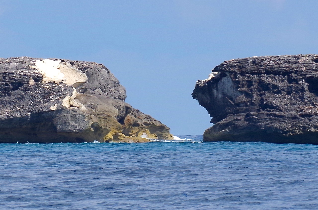
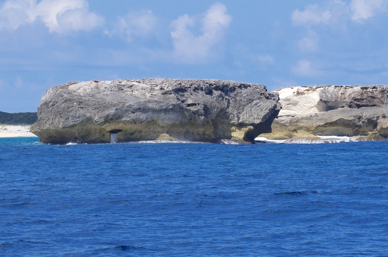
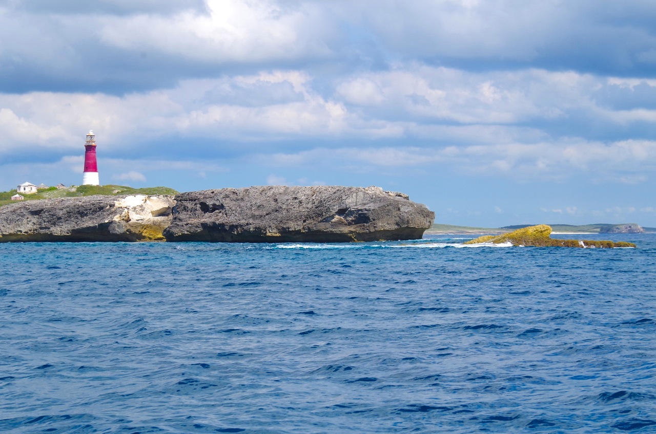
To begin with, here is a fabulous recent photograph of the actual Hole-in-the-Wall taken by well-known Abaco nature tour guide Ricky Johnson. This picture inspired me to delve into the history of Abaco and its the southernmost extremity, to see how far back it can be traced; and how the island’s recorded history has evolved since the Columbian era.

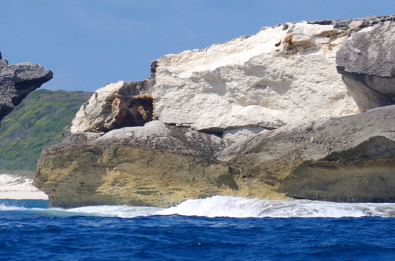
STOP PRESS March 2017  Thanks to the many people currently viewing this post & sharing it around. It was written, of course, before Hurricane Sandy converted the Hole into a Gap. There are links at the bottom of the page to some posts relating to the new ‘Gap-in-the-Wall’. In 2015 I went on the BMMRO research RHIB close to the hole / gap. If you are interested in the story and close- up photos, you’ll find them at HITW UNIQUE PERSPECTIVES ONE (past) and TWO (present & future).

(Photo Credit: Ricky Johnson)

I started by trying to establish the earliest map, and the earliest mention of Hole-in-the-Wall. I don’t have access to written archival material, so I looked instead at historic maps of the Caribbean / Bahamas / Lucayas. The very earliest, from the late c16, simply depict the Bahama Islands / Lucayas as rather random-looking blobs which bear little relation to their actual geographical location or their shape. The islands mostly have quite different names, or variants of familiar spellings. Over the course of 5 centuries, one can trace the progress of place names to those used today – including of Abaco itself. The gradual development of settlements can also been seen – at Little Harbour, Crossing Rocks and ‘Cheeric Sound’, for example, as well as on the ‘Keys’.

The trail starts in the c16. The earliest map I have so far found is the Abraham Ortelius map of 1592, which is a good example of the rather basic map-making of the time. It is quite hard – near impossible – to relate the position of ‘Haraco’ to the other islands depicted.

ADDENDUM I have now uncovered an even earlier and far more ambitious map published in 1550 by the Spanish cartographer Diego Gutiérrez. His incredibly intricate map, for the period, is decorated with volcanos, mermaids, monkeys, and variety of fantastical sea creatures. The first image is a detail of the whole map, showing the Bahamas, a sea monster, and a graphic shipwreck. I have also included an image of the whole map so that the extraordinary range and complexity of this early map can be seen in its entirety.

This colourful and charming 1679 map shows that a very basic style of mapping was still common in the c17

This famous map by A.M.Mallet from 1683, with its enjoyable sea battle vignette, is another good example of the very general nature of the maps, although the design and draftsmanship has advanced considerably

Things become much clearer and more detailed in the c18. The relationship of the islands to each other is shown in geographic reality; and many more details and place names are included. The earliest specific reference to Hole-in-the-Wall (as it now is) that I have so far found is in a 1738 map by Johannes Couvens & Cornelius Mortier. ‘Abaco’ is now spelled as we know it, with ‘Hole in the Rock’ clearly marked. Little Harbour is mentioned, as are 2 ‘Keys’, presumably indicating settlements. 

A 1750 map by Robert of Paris shows the southern tip of Abaco as ‘Trou dans le Roc’. You’ll have to trust me on this – the writing is tiny and impossible to enlarge legibly. The French name is not just because the map maker was French, but probably because it was the name given by French settlers who are believed to have lived in that part of Abaco in the c18 (and quite possibly earlier). Many more settlements are shown, especially on the Cays.

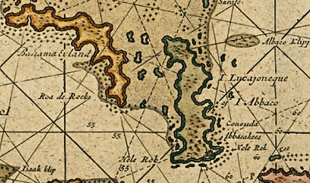
The Cartographer Jacques-Nicolas Bellin, in a 1764 map, also used the french name, though in the plural ‘Trou dans les Roches’, as this much enlarged portion of his ‘Cartes des Isles Lucayes’ shows. Little Harbour – ‘Petit Havre’ – is again included as a distinct settlement, and a few Cays are also named.

John Blair’s map of 1779, below, shows clearly ‘the Hole in the Rock’ – indeed, it is the only named place on Great Abaco. The southern end of Florida looks worryingly fragmented…

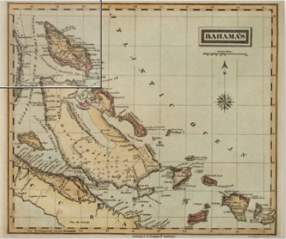
For the new century, a map by George Cook dated 1800 shows the first appearance of Little Abaco as a separate entity. Again, Hole in the Rock is the only place on Great Abaco that is marked. Maybe this evidences a continuing significance as a navigation aid.

The good clear map by Thompson dated 1815 provides plenty of excellent detail hitherto lacking in maps of the northern Bahamas. Another name for Hole-in-the-Wall has crept in, shown as ‘Hole of the Rock’. There are some oddities here. A ‘Rocky Point’, usually associated with the south west coast below Sandy Point, is marked on the east coast. Little Harbour is shortened to L.H., indicating perhaps that it had become a familiar enough settlement to warrant abbreviation – unless it stands for Light House, referring to the long-defunct lighthouse there… The word ‘Kay’ is used, a half-way house between the earlier ‘Key’ and the later ‘Cay’. The positions of the Kays seems (now) amusingly off-cay – indeed the relative scales to the main island are quite strange. Green Turtle Cay is some way nor’-nor’-west of Little Abaco…

Harrison’s much simpler map in 1818 also uses ‘Hole of the Rock’, which is the only place shown.                              

As the  c19 progressed, far more sophisticated and detailed map-making – including nautical charts – was undertaken. This extract from a much larger chart by Edmund Blunt from 1827 is the first mapped reference I can find of the name change from ‘Rock’ to ‘Wall’. It is also the earliest I have found Crossing Rocks mentioned on a map, though apparently as a shipping warning rather than an indication of a viable settlement. Walt Disney has yet to visit ‘Key Gorda’.

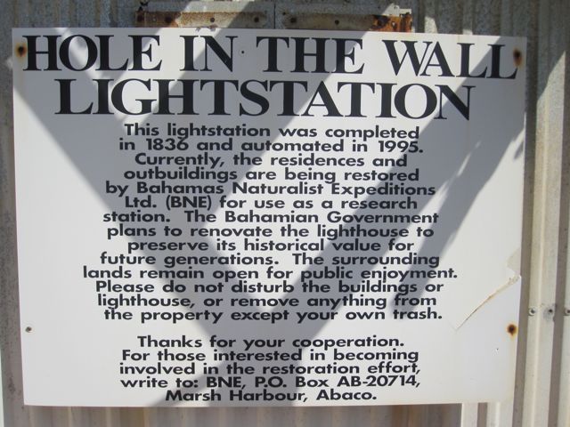
A new name for the southern extremity entered the scene in 1833 on Thomas Starling’s map of the West Indies. The tip is simply called ‘Light Ho. Pt’, with no reference to Holes, Rocks or Walls – an interesting variation (see below). I have found no other instances of this name.

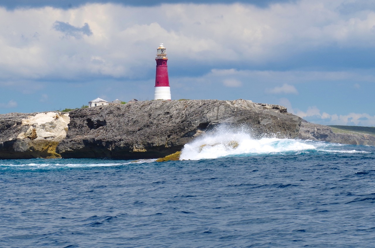
The interest lies in the fact that the evidence suggests that the Lighthouse at Hole-in-the-Wall was not actually completed until 1836, yet Starling was specifically referencing it 3 years earlier. One could deduce that there was already a basic lighthouse of some description there, soon to be superseded; or perhaps that construction of the Lightstation had already commenced in 1833, and Starling was confident of its eventual completion and wanted to be ahead of the competition… On the left is the notice at the lighthouse station today.

——————————————

For a time, maps continued to use ‘Rock’ rather than ‘Wall’ – the 1843 Findlay map has reverted to ‘Hole in the Rock’. Great and Little Abaco are again separately named.

In 1857, a very detailed nautical chart of the area was published. The survey seems to have been carried out by the British Navy for the French, and now detailed depth measurements enter the picture. It seems that new techniques have recently been discovered. I have used only one of the 3 areas mapped, a detail of the southern tip of Abaco. Here, in french, we are back to ‘Wall’ rather than ‘Rock’. For the first time, the lighthouse and associated lightstation buildings have been included, but I haven’t been able to decipher the words in brackets under ‘Phare’.

Mitchell, in a far more basic (pretty border though) 1872 map,reverts to ‘Hole in the Rock’

Two near-identical maps were published in the late c19: the first, by Hardesty, New York, in 1884; the second, by Rand McNally, in 1890. Extracts are shown below, side-by-side. This time, both clearly show ‘Hole in the Wall’. Cay is still spelled ‘Key’. And for the first time I have seen, Cherokee gets a mention as ‘Cheeric’ or ‘Cheerie’ Sound.


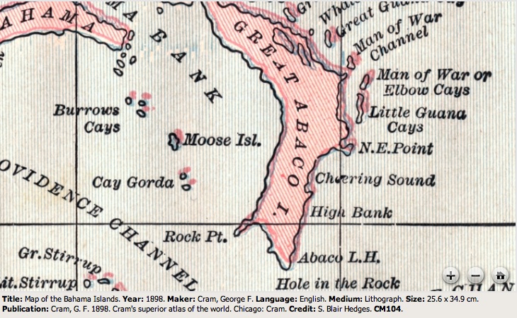
In the final year of the c19, George Cram of Chicago pubished the most ambitious map of the region so far. By 1899 shipping routes were so well-established that they could be added to maps, increasing their usefulness and therefore sales. He’s back to ‘Hole in the Rock’, though. The names of the Cays are more familiar here, and Pelican Harbor is now included. Cherokee is still in its early form.

The c20 saw the use of the name ‘Hole in the Wall’ becoming predominant, as shown on this Waterlow’s map from 1919. The map also uses the modern-day ‘Cherokee Sound’; and surprisingly this is the first map I came across that names Marsh Harbour (and also Wilson City). The map also marks all Bahamas lighthouses (oddly, although ‘Hole in the Wall’ is marked on a similar map from that period by Harrison & Sons, the red dot for the lighthouse is missing there – presumably in error, since the lighthouse was well-established and functioning at that time). I am left wondering when the hyphens became included in ‘Hole-in-the-Wall’. They are not universal, I have noticed, but seem to be the preferred usage nowadays, making the place a lot more niggly to type!

To end with, a photo of the lighthouse (now automatic) and some of the abandoned buildings. For an account of an intrepid trip to this part of South Abaco CLICK ===>>> ‘TO THE LIGHTHOUSE…

  • This post is by no means exhaustive, and any suggestions, additions or corrections are welcome by way of the COMMENT box or by email to rollingharbour.delphi@gmail.com
  • Apologies for the very small writing on many of the maps, but in most cases it was not possible to enlarge the image further without also making the written details illegible. 
  • The photos, apart from Ricky’s, are mine. Acknowledgement is given to the variety of sources used for the map extracts, which come mainly from catalogues / sales advertising or open online archives. Any problems? Let me know!

POST SCRIPT: I am very grateful to Marinas.com for permission to download this wonderful aerial image of Hole-in-the-Wall lighthouse and its outbuildings, looking towards the southern tip of Abaco. They have generously enabled a completely cost and watermark-free download. I have added the © detail. Thanks, guys. 

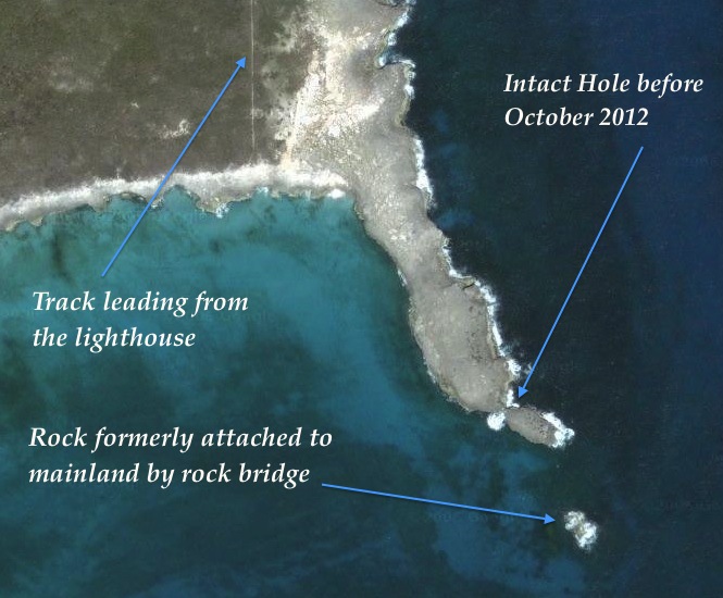
AFTERTHOUGHT I have received a query as to exactly where the eponymous Hole in the Wall, or Rock, can be found in relation to the lighthouse. At the foot of the page is an annotated map which I should no doubt have provided in the first place. The consensus of those who have walked to it (I haven’t yet) is that you’d be well advised to wear walking shoes / boots. Mary Wallace Chamie in a recent POST (check out the link for her VG photos, of which I have included 2 small tasters) says this:

“At first the hike was easy as we followed a cement path through a maze of sea grapes and then hiked further down until we reached the beach.  We took a left at the beach and started hiking across limestone that was full of potholes and sharp edges.  We walked carefully through the maze until we reached a point where we could finally see the Hole in the Wall.


We then headed back across the limestone craters and up the hill to the lighthouse.  One suggestion I have to any beach comber who takes this hike.  Wear your walking shoes! ” 

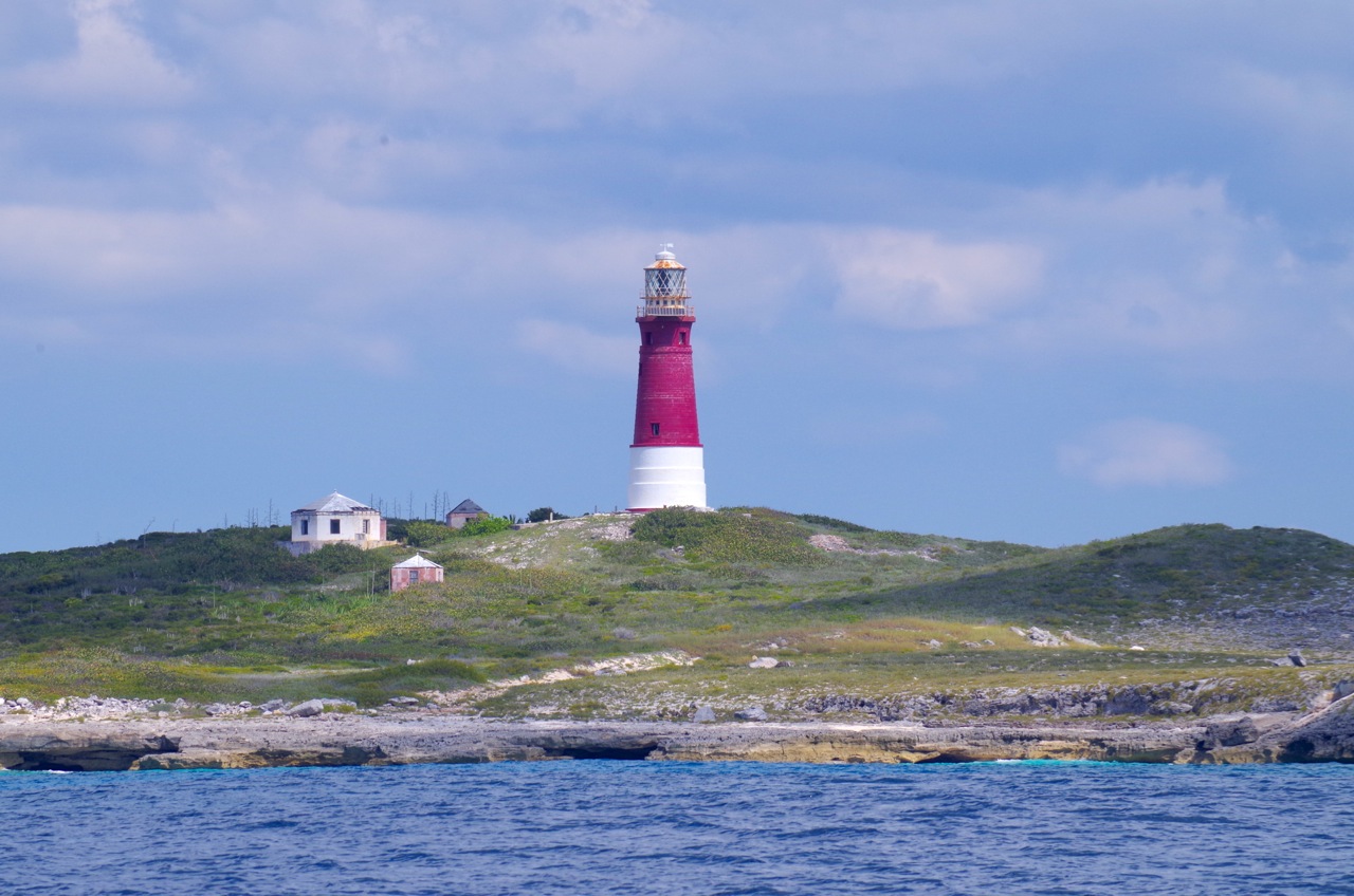
To which I can now add this ‘distance shot’ from the sea, which makes it all completely clear. I have contacted the photographer via Panoramia but had no reply. Credit as annotated. If you are the photographer, Hi!. And if you object to its inclusion, please let me know and I’ll remove it…

LINKS TO OTHER HOLE-IN-THE-WALL POSTS

ABACO HISTORY: SHIPS, MAPS & HOLE-IN-THE-WALL

HOLE-IN-THE-WALL ABACO: HISTORIC 1803 DESCRIPTION & AQUATINT

HOLE-IN-THE-WALL TO GAP-IN-THE-WALL: HURRICANE SANDY SMASHES ABACO LANDMARK 

HOLE-IN-THE-WALL BEFORE SANDY DEMOLITION: FIRST & LAST EVER IMAGES

HOLE-IN-THE-WALL, ABACO: THE ‘HOLE’ THAT’S NO LONGER A WHOLE

HOLE-IN-THE WALL ABACO: “MIND THE GAP” – A NEW ISLET IS BORN

Unknown's avatar

BOOK REVIEW – ABACO: HISTORY OF AN OUT ISLAND & ITS CAYS


STEVE DODGE, illus. Laurie Jones – White Sound Press

• Original Edition 1983 (170pp), reprinted                     rollingharbour rating ****     • Revised and expanded edition 2005 (270pp)                    [I don’t have it!]

These are the 2 covers, to help distinguish them if you search online. Beware, the covers are often used interchangeably… so check the edition date


The cover image, colourfully made over for the new century, shows the Albertine ‘Adoue’ – the last Abaconian sailing mailboat (giving way to diesel power in 1923)

1st EDITION REVIEW: The first 5 chapters cover the more distant history of the Bahamas in general & Abaco in particular. Starting promisingly “Two hundred million year ago…”, the early chapters briefly cover the formation & geology of the islands and the demographic & social history, with plenty to interest and not too much detail – very informative for a non-Abaconian like me. I personally am uninterested in the boatbuilding chapter (I like the illustrations) but it will surely appeal to people who feel comfortable out of their depth. The history of gradual expansion, increased trading importance, & the less attractive sides – e.g. wrecking – are well-covered. 

The final 3 chapters form the second half of the book – the 20th Century when Abaco moved from relative isolation to greater significance. Here the detail becomes denser as Abaco rapidly develops. There are parts that I skimmed, but there’s much of interest and many factual nuggets about the political developments in the later 20th century. Overall the book is an excellent primer for an Abaco novice for an overview up to the 1980s. I guess residents will also get plenty from it as well.

I haven’t seen the new edition, but I am sure it is the one to get. The Am*z*n blurb for it, which I recklessly copy, says “This expanded and updated second edition has completely new sections on Lucayan Indians, Wilson City, and contemporary Abaco, and many revisions. This is the only general, comprehensive history of Abaco, Bahamas available; it covers from the geologic formation of the Bahama Banks to the middle 1990s. Cover painting by Phil Capen,; illustrations by Laurie Jones. 112 illustrations, photographs, and maps. Appendix on boat building in Abaco”  There are plainly many more illustrations and photos than in my copy; and I notice boatbuilding has been moved to an Appendix…

CURRENT COST: Unlike most of the books I have reviewed, this book is not cheap at the moment. The new edition can be bought for $25 on Amazon.com /  £33 on Amazon.co.uk – none on Abe. The original edition is a mere $4 on Amazon.com, unfeasibly expensive on Amazon.co.uk, but reasonable on Abe